

Daryabar Fossa
Encyclopedia
Trough (geology)
In geology, a trough generally refers to a linear structural depression that extends laterally over a distance, while being less steep than a trench.A trough can be a narrow basin or a geologic rift....
on Saturn
Saturn
Saturn is the sixth planet from the Sun and the second largest planet in the Solar System, after Jupiter. Saturn is named after the Roman god Saturn, equated to the Greek Cronus , the Babylonian Ninurta and the Hindu Shani. Saturn's astronomical symbol represents the Roman god's sickle.Saturn,...
's moon Enceladus
Enceladus (moon)
Enceladus is the sixth-largest of the moons of Saturn. It was discovered in 1789 by William Herschel. Until the two Voyager spacecraft passed near it in the early 1980s very little was known about this small moon besides the identification of water ice on its surface...
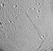
. Daryabar Fossa was first seen in Voyager 2
Voyager 2
The Voyager 2 spacecraft is a 722-kilogram space probe launched by NASA on August 20, 1977 to study the outer Solar System and eventually interstellar space...
images, though a small section was see at much higher resolution by Cassini. It is centered at 9.7° North Latitude
Latitude
In geography, the latitude of a location on the Earth is the angular distance of that location south or north of the Equator. The latitude is an angle, and is usually measured in degrees . The equator has a latitude of 0°, the North pole has a latitude of 90° north , and the South pole has a...
, 359.1° West Longitude
Longitude
Longitude is a geographic coordinate that specifies the east-west position of a point on the Earth's surface. It is an angular measurement, usually expressed in degrees, minutes and seconds, and denoted by the Greek letter lambda ....
and is approximately 201 kilometers long. Based on limb profiles of Voyager 2 images, Daryabar Fossa was determined to be a 400-meter deep and 4 kilometers wide (Kargel and Pozio 1996). Daryabar Fossa runs perpendicular to the scarp Isbanir Fossa
Isbanir Fossa
Isbanir Fossa is a north-south trending scarp on Saturn's moon Enceladus. Isbanir Fossa was first seen in Voyager 2 images, though a small section was see at much higher resolution by Cassini. It is centred at 12.6° North Latitude, 354.0° West Longitude and is approximately 132 kilometres long...
and is right-laterally offset 15–20 km by the scarp, suggesting Isbanir
Isbanir
Isbanir is a city referred to in the 1001 Nights as the home of Fakir Taj. It is believed to be based on the real-life Persian city of Asbanbar , which was one of the seven cities that entailed the Persian capital Ctesiphon. Isbanir is a corruption of the name Asbanbar or Aspanbar....
is a strike-slip or transform fault
Transform fault
A transform fault or transform boundary, also known as conservative plate boundary since these faults neither create nor destroy lithosphere, is a type of fault whose relative motion is predominantly horizontal in either sinistral or dextral direction. Furthermore, transform faults end abruptly...
(Rothery 1999).
Daryabar Fossa is named for the land from which Princess Daryabar came in One Thousand and One Nights. The word Daryabar is Persian
Persian language
Persian is an Iranian language within the Indo-Iranian branch of the Indo-European languages. It is primarily spoken in Iran, Afghanistan, Tajikistan and countries which historically came under Persian influence...
دریابار and means "Seaside".