
Dang Deokhuri District
Encyclopedia
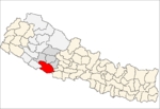
Dang-Deukhuri, District
is an Inner Terai
district some 280 km west of Kathmandu in Rapti
Zone
of Nepal
's Mid-Western
Region
. Dang-Deukhuri covers an area of 2,955 km² with population (2001) of 462,380. Tribhuwannagar (usually called Ghorahi) is the district's administrative center.
valleys, Dang and Deukhuri, plus enclosing ranges of hills and mountains. Downsteam, both valleys cross into Banke District
, Bheri Zone
.
To the south, the district borders Uttar Pradesh
, India
-- specifically Balarampur and Shravasti district
s of Awadh
. Because the international border follows the southern edge of the outermost Siwalik foothills called the Dudhwa Range, there is no Nepalese Outer Terai extending onto the main Ganges Plain in this district. The permeable geology of the Siwaliks does not support moisture retention or soil development so they are covered with unproductive scrub forest.
The Dudhwas rise steeply to a crest at about 700 meters then slope down gradually into Deukhuri Valley, to 250 meters at the Rapti River
. The Dudhwas extend more than 100 km, causing the Rapti to detour west around them before turning SE down the overall trend of the plains into India. Deukhuri's climate is nearly tropical and it is well watered by the river as well as abundant groundwater.
North of Deukhuri Valley the Dang Range rises to peaks as high as 1,000 meters with passes at about 700 meters. Dang Valley lies north of these hills, at elevations from 600 meters along the Babai River with alluvial slopes gradually rising northward to 700 meters along the base of the Mahabharat Range. Then the district extends upslope to the crest of the Mahabharats at 1,500 to 1,700 meters elevation. Bordering districts to the north are Pyuthan
, Rolpa
and Salyan
.
-- the main east-west highway across Nepal -- follows Deukhuri Valley, passing Bhalubang bazar at the upper end and Lamahi downstream. From Bhalubang, branch roads lead up the Rapti River into Pyuthan
and Rolpa District
s. From Lahami there are roads north across the Dang Range to Tulsipur
and Tribuvannagar, and south over the Dudhwas to Koilabas
bazaar on the international border where goods enter Rapti Zone from India. At Tulsipur, all-weather [TARIGAUN AIRPORT ABOT 1.5 KM FAR FROM TULSIPUR] has scheduled connections to other cities in Nepal and a motorable road goes north into Salyan District
.
charm with its lazy river, thick jungle alternating with rice paddies, surrounding hills in the middle distance, and unique peoples.
Dang Valley is higher, less tropical, drier and less malarial than Deukhuri. Despite poorer soil and more seasonal streamflow, its healthier climate made it more attractive to settlers from outside even before the introduction of DDT.
Since the early 1990s activist groups have been attempting to eradicate the practice of child indentured servitude among the Tharu, many of whom sold young daughters to wealthy families in urban areas.
The steep, virtually uninhabited southern slopes of the Mahabharat Range are another cultural buffer zone between traditional Tharu lands and the culturally distinct Middle Hills where Nepali
is the dominant language, the homeland of Nepal's politically dominant Bahun
s and Chhetris.
Districts of Nepal
Nepal's 14 administrative zones are subdivided into 75 districts . These districts are listed below, by zone...
is an Inner Terai
Inner Terai Valleys of Nepal
The Inner Terai Valleys or Bhitri tarai are various elongated valleys in Nepal situated between the Himalayan foothills, the 600–900 m high Siwalik or Churia Range and the 2,000-3,000 m high Mahabharat Range further north. Major examples are the Chitwan Valley southwest of Kathmandu and the...
district some 280 km west of Kathmandu in Rapti
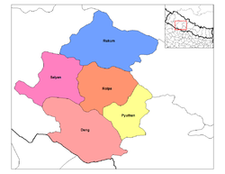
Rapti Zone
Rapti Anchal in the Mid-Western Development Region of Nepal. It is named after the West Rapti River which drains Rolpa, Pyuthan and part of Dang district. The remainder of Dang and part of Salyan are drained by the Babai. The remainder of Salyan and all of Rukum are drained by the Bheri.The...
Zone
Zones of Nepal
Nepal is divided into 14 administrative zones , and 75 districts . The 14 administrative zones are grouped into five development regions...
of Nepal
Nepal
Nepal , officially the Federal Democratic Republic of Nepal, is a landlocked sovereign state located in South Asia. It is located in the Himalayas and bordered to the north by the People's Republic of China, and to the south, east, and west by the Republic of India...
's Mid-Western
Mid-Western Region, Nepal
Mid-Western Region is one of Nepal's five development regions. Westward from the Central region surrounding Kathmandu are the Western, Mid-Western and finally Far-Western regions. Counter-intuitively, Mid-Western lies west of Western....
Region
Regions of Nepal
Nepal is divided into 14 administrative zones , which are divided into 75 districts . The 14 administrative zones are grouped into five development regions...
. Dang-Deukhuri covers an area of 2,955 km² with population (2001) of 462,380. Tribhuwannagar (usually called Ghorahi) is the district's administrative center.
Geography
This district consists of the larger easterly and upstream portions of parallel Inner TeraiInner Terai Valleys of Nepal
The Inner Terai Valleys or Bhitri tarai are various elongated valleys in Nepal situated between the Himalayan foothills, the 600–900 m high Siwalik or Churia Range and the 2,000-3,000 m high Mahabharat Range further north. Major examples are the Chitwan Valley southwest of Kathmandu and the...
valleys, Dang and Deukhuri, plus enclosing ranges of hills and mountains. Downsteam, both valleys cross into Banke District
Banke District
-Geography:Banke is bordered on the west by Bardiya district. Rapti zone's Salyan and Dang Deukhuri Districts border to the north and east. To the south lies Uttar Pradesh, India; specifically Shravasti and Bahraich districts of Awadh. East of Nepalganj the international border follows the...
, Bheri Zone
Bheri Zone
Bheri Anchal in the Mid-Western Development Region of Nepal. Nepalgunj is the administrative headquarters.Cities and towns are Narayan, Jajarkot and Chhinchu in the "hills"; Nepalgunj, Gularia and Kohalpur in Terai; Birendranagar in Surkhet Valley in the Inner Terai.Bheri Zone is divided into five...
.
To the south, the district borders Uttar Pradesh
Uttar Pradesh
Uttar Pradesh abbreviation U.P. , is a state located in the northern part of India. With a population of over 200 million people, it is India's most populous state, as well as the world's most populous sub-national entity...
, India
India
India , officially the Republic of India , is a country in South Asia. It is the seventh-largest country by geographical area, the second-most populous country with over 1.2 billion people, and the most populous democracy in the world...
-- specifically Balarampur and Shravasti district
Shravasti District
Shravasti District is one of the districts of the Uttar Pradesh state of India and Bhinga town is district headquarter. Shravasti district is a part of Devipatan Division...
s of Awadh
Awadh
Awadh , also known in various British historical texts as Oudh or Oude derived from Ayodhya, is a region in the centre of the modern Indian state of Uttar Pradesh, which was before independence known as the United Provinces of Agra and Oudh...
. Because the international border follows the southern edge of the outermost Siwalik foothills called the Dudhwa Range, there is no Nepalese Outer Terai extending onto the main Ganges Plain in this district. The permeable geology of the Siwaliks does not support moisture retention or soil development so they are covered with unproductive scrub forest.
The Dudhwas rise steeply to a crest at about 700 meters then slope down gradually into Deukhuri Valley, to 250 meters at the Rapti River
West Rapti River
Not to be confused with the East Rapti in Chitwan Valley some to the east, this Rapti drains Rapti Zone in Mid-Western Region, Nepal, then Awadh and Purvanchal regions of Uttar Pradesh state, India before joining the Ghaghara a major left bank tributary of the Ganges.The West Rapti is notable for...
. The Dudhwas extend more than 100 km, causing the Rapti to detour west around them before turning SE down the overall trend of the plains into India. Deukhuri's climate is nearly tropical and it is well watered by the river as well as abundant groundwater.
North of Deukhuri Valley the Dang Range rises to peaks as high as 1,000 meters with passes at about 700 meters. Dang Valley lies north of these hills, at elevations from 600 meters along the Babai River with alluvial slopes gradually rising northward to 700 meters along the base of the Mahabharat Range. Then the district extends upslope to the crest of the Mahabharats at 1,500 to 1,700 meters elevation. Bordering districts to the north are Pyuthan
Pyuthan District
Pyuthan District of 212,484. Pyuthan Khalanga is the district's administrative center.-Geography:Pyuthan borders Dang Deukhuri District to the southwest along the crest of the Mahabharat Range and extends about 50 km northeast through the Middle Hills to a 3,000+ meter ridge that is both...
, Rolpa
Rolpa District
Rolpa of 210,004. Livang is the district's administrative center.By Nepalese standards, Rolpa is an underdeveloped area plagued by low life expectancy and poverty . It was a major flashpoint in the 1996-2006 Civil War.Adjoining districts are Dang to the south, Pyuthan to the east, Salyan to the...
and Salyan
Salyan District
Salyan District of 213,500. The district's administrative center is named Salyan or Salyan Khalanga.The district is known for its Hindu temples including Shiva temples in Chhayachhetra and Laxmipur, and the Devi temple at Khairabang in Hiwalcha VDC, one of nine in Nepal...
.
Transportation
Mahendra HighwayMahendra Highway
Mahendra Highway also called East West Highway runs across the Terai region of Nepal, from Kankarbhitta in the east to Mahendranagar in the west, cutting across the entire width of the country. It is the longest highway in Nepal.-Overview:...
-- the main east-west highway across Nepal -- follows Deukhuri Valley, passing Bhalubang bazar at the upper end and Lamahi downstream. From Bhalubang, branch roads lead up the Rapti River into Pyuthan
Pyuthan District
Pyuthan District of 212,484. Pyuthan Khalanga is the district's administrative center.-Geography:Pyuthan borders Dang Deukhuri District to the southwest along the crest of the Mahabharat Range and extends about 50 km northeast through the Middle Hills to a 3,000+ meter ridge that is both...
and Rolpa District
Rolpa District
Rolpa of 210,004. Livang is the district's administrative center.By Nepalese standards, Rolpa is an underdeveloped area plagued by low life expectancy and poverty . It was a major flashpoint in the 1996-2006 Civil War.Adjoining districts are Dang to the south, Pyuthan to the east, Salyan to the...
s. From Lahami there are roads north across the Dang Range to Tulsipur
Tulsipur, Rapti
Tulsipur is a town and V.D.C. in Dang Deokhuri District in the Rapti Zone of south-western Nepal. It is also the district's main bazaar. The 1991 Nepal census counted 13,815 persons in 2,540 households. Dang Airport is about two km south of the town center...
and Tribuvannagar, and south over the Dudhwas to Koilabas
Koilabas
Koilabas is a bazaar town and Village Development Committee in Dang Deokhuri District in Rapti Zone of south-western Nepal. The town is situated on the southern edge of the Dudhwa Range of the Siwaliks, at Nepal's border with Uttar Pradesh...
bazaar on the international border where goods enter Rapti Zone from India. At Tulsipur, all-weather [TARIGAUN AIRPORT ABOT 1.5 KM FAR FROM TULSIPUR] has scheduled connections to other cities in Nepal and a motorable road goes north into Salyan District
Salyan District
Salyan District of 213,500. The district's administrative center is named Salyan or Salyan Khalanga.The district is known for its Hindu temples including Shiva temples in Chhayachhetra and Laxmipur, and the Devi temple at Khairabang in Hiwalcha VDC, one of nine in Nepal...
.
Demography
The droughty and agriculturally unproductive Dudhwa range creates a buffer zone between the divergent cultures of the plains of Uttar Pradesh and the Inner Terai. Deukhuri was severely malarial before the late 1950s when DDT came into use to suppress mosquitos so that Tharu people who had evolved resistance managed to live in isolation from more developed and avaricious cultures of the plains to the south and the hills to the north. Although road development further reduced Deukhuri's isolation by the 1980s, the valley retains some of its Garden of EdenGarden of Eden
The Garden of Eden is in the Bible's Book of Genesis as being the place where the first man, Adam, and his wife, Eve, lived after they were created by God. Literally, the Bible speaks about a garden in Eden...
charm with its lazy river, thick jungle alternating with rice paddies, surrounding hills in the middle distance, and unique peoples.
Dang Valley is higher, less tropical, drier and less malarial than Deukhuri. Despite poorer soil and more seasonal streamflow, its healthier climate made it more attractive to settlers from outside even before the introduction of DDT.
Since the early 1990s activist groups have been attempting to eradicate the practice of child indentured servitude among the Tharu, many of whom sold young daughters to wealthy families in urban areas.
The steep, virtually uninhabited southern slopes of the Mahabharat Range are another cultural buffer zone between traditional Tharu lands and the culturally distinct Middle Hills where Nepali
Nepali language
Nepali or Nepalese is a language in the Indo-Aryan branch of the Indo-European language family.It is the official language and de facto lingua franca of Nepal and is also spoken in Bhutan, parts of India and parts of Myanmar...
is the dominant language, the homeland of Nepal's politically dominant Bahun
Bahun
Bahun is a colloquial Nepali term for a member of the Pahari or "hill" Brahmin caste, who are traditionally educators, scholars and priests of Hinduism. They are also known as Barmu in Newari. By tradition—and by civil law until 1962—they represented the highest of the four Hindu...
s and Chhetris.
Towns and villages
- AmritpurAmritpur, NepalAmritpur is a town and Village Development Committee in Dang Deokhuri District in the Rapti Zone of south-western Nepal. At the time of the 1991 Nepal census it had a population of 9,680 persons living in 1725 individual households.-External links:*...
- BaghmareBaghmareBaghmare is a town and Village Development Committee in Dang Deokhuri District in the Rapti Zone of south-western Nepal. At the time of the 1991 Nepal census it had a population of 5,965 persons living in 1075 individual households.-External links:*...
, BelaBela, NepalBela is a Village Development Committee in Dang Deokhuri District in the Rapti Zone of south-western Nepal.The village borders Balrampur district of India in the south. At the time of the 1991 Nepal census it had a population of 7,131 persons living in 1106 individual households.The main residents...
, BijauriBijauriBijauri is a town and Village Development Committee in Dang Deokhuri District in the Rapti Zone of south-western Nepal. At the time of the 1991 Nepal census it had a population of 9,729 persons living in 1599 individual households.-External links:*... - Chailahi, Lamahi
- DhanauriDhanauriDhanauri is a town and Village Development Committee in Dang Deokhuri District in the Rapti Zone of south-western Nepal. At the time of the 1991 Nepal census it had a population of 12,403 persons living in 1905 individual households.-External links:*...
, DharnaDharna, NepalDharna is a town and Village Development Committee in Dang Deokhuri District in the Rapti Zone of south-western Nepal. At the time of the 1991 Nepal census it had a population of 5,527 persons living in 961 individual households.-External links:*...
, DhikpurDhikpurDhikpur is a town and Village Development Committee in Dang Deokhuri District in the Rapti Zone of south-western Nepal. At the time of the 1991 Nepal census it had a population of 8,085 persons living in 1112 individual households.-External links:*...
, Duruwa - GadhawaGadhawaGadhawa is a town and Village Development Committeenow known as Typical Village Development Committee in Dang Deokhuri District in the Rapti Zone of south-western Nepal. At the time of the 1991 Nepal census it had a population of 7,877 persons living in 1188 individual households...
, Gangaparaspur, Goltakuri, GobardiyaGobardiyaGobardiya is a town and Village Development Committee in Dang Deokhuri District in the Rapti Zone of south-western Nepal. At the time of the 1991 Nepal census it had a population of 10,755 persons living in 1524 individual households.-External links:*... - HalwarHalwarHalwar is a town and Village Development Committee in Dang Deokhuri District in the Rapti Zone of south-western Nepal. At the time of the 1991 Nepal census it had a population of 8,182 persons living in 1339 individual households.-External links:*...
, HansipurHansipurHansipur is a town and Village Development Committee in Dang Deokhuri District in the Rapti Zone of south-western Nepal. At the time of the 1991 Nepal census it had a population of 5,891 persons living in 987 individual households.-External links:*...
, HapurHapur, NepalHapur is a town and Village Development Committee in Dang Deokhuri District in the Rapti Zone of south-western Nepal. At the time of the 1991 Nepal census it had a population of 10,424 persons living in 1788 individual households.-External links:*...
, HekuliHekuliHekuli is a town and Village Development Committee in Dang Deokhuri District in the Rapti Zone of south-western Nepal. At the time of the 1991 Nepal census it had a population of 8,512 persons living in 1139 individual households.-External links:*...
, - KabhreKabhre, RaptiKabhre is a town and Village Development Committee in Dang Deokhuri District in the Rapti Zone of south-western Nepal. At the time of the 1991 Nepal census it had a population of 6,033 persons residing in 1142 individual households.-External links:*...
, KoilabasKoilabasKoilabas is a bazaar town and Village Development Committee in Dang Deokhuri District in Rapti Zone of south-western Nepal. The town is situated on the southern edge of the Dudhwa Range of the Siwaliks, at Nepal's border with Uttar Pradesh... - Lalmatiya, LaxmipurLaxmipur, Dang DeokhuriLaxmipur is a town and Village Development Committee in Dang Deokhuri District in the Rapti Zone of south-western Nepal. At the time of the 1991 Nepal census it had a population of 9,075 persons residing in 1493 individual households.-External links:*...
, LoharpaniLoharpaniLoharpani is a town and Village Development Committee in Dang Deokhuri District in the Rapti Zone of south-western Nepal. At the time of the 1991 Nepal census it had a population of 4,789 persons living in 811 individual households.-External links:*... - ManpurManpur, RaptiManpur is a town and Village Development Committee in Dang Deokhuri District in the Rapti Zone of south-western Nepal. At the time of the 1991 Nepal census it had a population of 9,962 persons residing in 1449 individual households.-External links:*...
- NarayanpurNarayanpur, RaptiNarayanpur is a town and Village Development Committee in Dang Deokhuri District in the Rapti Zone of south-western Nepal. At the time of the 1991 Nepal census it had a population of 8,646 persons living in 1143 individual households.-External links:*...
- PanchakulePanchakulePanchakule is a town and Village Development Committee in Dang Deokhuri District in the Rapti Zone of south-western Nepal. At the time of the 1991 Nepal census it had a population of 6,270 persons living in 1019 individual households.-External links:*...
, Pawan NagarPawan NagarPawan Nagar is a town and Village Development Committee in Dang Deokhuri District in the Rapti Zone of south-western Nepal. At the time of the 1991 Nepal census it had a population of 11,428 persons living in 1961 individual households.-External links:*...
, PhulbariPhulbari, RaptiPhulbari is a town and Village Development Committee in Dang Deokhuri District in the Rapti Zone of south-western Nepal. At the time of the 1991 Nepal census it had a population of 4,462 persons residing in 745 individual households.-External links:*...
, PurandharaPurandharaPurandhara is a town and Village Development Committee in Dang Deokhuri District in the Rapti Zone of south-western Nepal. At the time of the 1991 Nepal census it had a population of 11,981 persons living in 2033 individual households.-External links:*...
, - RajpurRajpur, RaptiRajpur is a town and Village Development Committee in Dang Deokhuri District in the Rapti Zone of south-western Nepal. At the time of the 1991 Nepal census it had a population of 8,811 persons residing in 1454 individual households.-External links:*...
, RampurRampur, Dang DeokhuriRampur is a town and Village Development Committee in Dang Deokhuri District in the Rapti Zone of south-western Nepal. At the time of the 1991 Nepal census it had a population of 9,422 persons living in 1576 individual households.-External links:*...
, - Saigha, SatbariyaSatbariyaSatbariya is a town and Village Development Committee in Dang Deokhuri District in the Rapti Zone of south-western Nepal. At the time of the 1991 Nepal census it had a population of 8,829 persons living in 1258 individual households.-External links:*...
, SaudiyarSaudiyarSaudiyar is a town and Village Development Committee in Dang Deokhuri District in the Rapti Zone of south-western Nepal. At the time of the 1991 Nepal census it had a population of 8,052 persons living in 1067 individual households.-External links:*...
, ShantinagarShantinagar, RaptiShantinagar is a town and Village Development Committee in Dang Deokhuri District in the Rapti Zone of south-western Nepal. At the time of the 1991 Nepal census it had a population of 8,854.-External links:*...
, ShreegaunShreegaunShreegaun is a town and Village Development Committee in Dang Deokhuri District in the Rapti Zone of south-western Nepal. At the time of the 1991 Nepal census it had a population of 6,602.-External links:*...
, SisahaniyaSisahaniya, RaptiSisahaniya is a town and Village Development Committee in Dang Deokhuri District in the Rapti Zone of south-western Nepal. At the time of the 1991 Nepal census it had a population of 11,972 persons living in 1530 individual households.-External links:*...
, SonpurSonpur, NepalSonpur is a town and Village Development Committee in Dang Deokhuri District in the Rapti Zone of south-western Nepal. At the time of the 1991 Nepal census it had a population of 8,650 persons living in 1129 individual households.-External links:*...
, SyujaSyujaSyuja is a town and Village Development Committee in Dang Deokhuri District in the Rapti Zone of south-western Nepal. At the time of the 1991 Nepal census it had a population of 4,137 persons living in 781 individual households.-External links:*... - TarigaunTarigaunTarigaun is a town and Village Development Committee in Dang Deokhuri District in the Rapti Zone of south-western Nepal. At the time of the 1991 Nepal census it had a population of 7,685 persons living in 1087 individual households.-External links:*...
, Tribhuwan NagarTribhuvannagarTribhuvan Nagar, renamed as Ghorahi is a municipality of Dang Valley, Dang Deokhuri District of Rapti Zone, southwest Nepal.Tribhuvannagar can be reached by the road that goes 23 kilometers North from Lamahi, a small town on the Mahendra highway....
, TulsipurTulsipur, RaptiTulsipur is a town and V.D.C. in Dang Deokhuri District in the Rapti Zone of south-western Nepal. It is also the district's main bazaar. The 1991 Nepal census counted 13,815 persons in 2,540 households. Dang Airport is about two km south of the town center... - UrahariUrahariUrahari is a town and Village Development Committee in Dang Deokhuri District in the Rapti Zone of south-western Nepal. At the time of the 1991 Nepal census it had a population of 8,764 persons living in 1288 individual households.-External links:*...
- Bhalubang: This town is on the eastern side of the Deukhuri valley. It lies on the side of Rapti river.
- Maurighat, Sisahaniya
Historic, cultural and archeological sites
- Amarai Temple, Ambikswari Temple
- Barakune Daha
- Chhilli kot, Chhilli Kot Gupha
- Dharapani
- Hanuman Temple
- Kalimai Temple
- Mulkot Cave
- Ram Janaki Temple, Ratnanath
- Sirasthan, Srigaun Temple, Sukaura Mound
- Taptakunda Shivalaya
- Shiva Mandir, Dhankhola,
- Shiva Cave, Dhankhola,
- Mata Malmala Devi
- Jakhera Tal Temple (Narayan puri)
- House of TulsipurHouse of TulsipurThe Royal House of Tulsipur or Tulsipur-Dang was one of 22 principalities in the Baise Rajya confederation of the western Rapti region before the unification of Nepal, c. 1760. The Rajas of Tulsipur-Dang belonged to the Chauhan clan...
- Formerly Tulsipur-Dang, one of 22 Principalities in Nepal and later on known as One of Taluqs of Oudh in India