
Dandenong Ranges
Encyclopedia
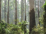
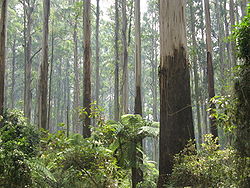
The Dandenong Ranges are a set of low mountain ranges, rising to 633 metres at Mount Dandenong, approximately 35 km east of Melbourne
, Victoria
, Australia
. The ranges consists mostly of rolling hills, steeply weathered valleys and gullies covered in thick temperate rainforest, predominantly consisting of tall Mountain Ash
trees and dense ferny undergrowth.
After European settlement in the region, the range was used as a main source of timber for Melbourne. The ranges were popular with day-tripper
s from the 1870s onwards. Much of the Dandenongs were protected by parklands as early as 1882 and by 1987 these parklands were amalgamated to form the Dandenong Ranges National Park
, which was added to again in 1997. The range experiences light to moderate snow
falls a few times most years, frequently between late winter and late spring.
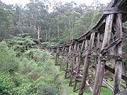
Today, the Dandenongs are home to over 100,000 residents and the area is popular amongst visitors, many of which stay for the weekend at the various Bed & Breakfasts through the region. The popular Puffing Billy Railway
, a heritage steam railway, runs through the southern parts of the Dandenongs.
language of the Wurundjeri
people.
It is suspected that the name Dandenong was applied to the ranges because Dandenong Creek
originates there, however, the original name for Dandenong Creek was Narra Narrawong. It is not known where the name Dandenong came from nor what it means, or even its correct spelling, other variations include; Tanjenong, Tangynon and Bangeong. In any case, both names relate at least to watercourses in general, and not to mountains or ranges, as indicated by the ong ending.
So as the name Dandenong may not actually apply to anything in the immediate area, the relevance of the name Corhanwarrabul becomes apparent. Carhanwarrabul was the original name for one of the two main summits, perhaps both or perhaps the entire range. The name applied to the main summits and was in continued use up until around 1900, when the name Dandenong appeared. At any rate, Corhanwarrabul remains the most relevant name for the ranges to date.
 Consisting predominantly of Devonian dacite
and rhyodacite, the topography consists of a series of ridges dissected by deeply-cut streams. Sheltered gullies in the south of the range are home to temperate rain forest, fern gullies and Mountain Ash forest Eucalyptus regnans
, whereas the drier ridges and exposed northern slopes are covered by dry sclerophyll
forest of stringybark
s and box. The entire range is highly prone to bushfires, the most recent of which have been the 1983 Ash Wednesday
bushfires, the 1997 Dandenong Ranges bushfires
and small fires during the Black Saturday bushfires in 2009.
A number of watercourses originate in the Dandenongs, these include:
Some settlements located on and around the plateau to the east of the ranges are sometimes included (14,200~):
Settlements in the western foothills are also sometimes included (34,500~):
 The ranges are located near the boundary between the Wurundjeri
and Bunurong
nations territories. The two nations were part of the Kulin
alliance and were most often on friendly terms. The mountain range however was not often frequented by either nations people as mountainous areas were often considered one of many resting places for various spirits.
In 1938, the aircraft Kyeema
crashed on the western face of Mount Corhanwarrabul due to heavy fog and poor navigation, 18 people died.
Melbourne
Melbourne is the capital and most populous city in the state of Victoria, and the second most populous city in Australia. The Melbourne City Centre is the hub of the greater metropolitan area and the Census statistical division—of which "Melbourne" is the common name. As of June 2009, the greater...
, Victoria
Victoria (Australia)
Victoria is the second most populous state in Australia. Geographically the smallest mainland state, Victoria is bordered by New South Wales, South Australia, and Tasmania on Boundary Islet to the north, west and south respectively....
, Australia
Australia
Australia , officially the Commonwealth of Australia, is a country in the Southern Hemisphere comprising the mainland of the Australian continent, the island of Tasmania, and numerous smaller islands in the Indian and Pacific Oceans. It is the world's sixth-largest country by total area...
. The ranges consists mostly of rolling hills, steeply weathered valleys and gullies covered in thick temperate rainforest, predominantly consisting of tall Mountain Ash
Eucalyptus regnans
Eucalyptus regnans, known variously by the common names Mountain Ash, Victorian Ash, Swamp Gum, Tasmanian Oak or Stringy Gum, is a species of Eucalyptus native to southeastern Australia, in Tasmania and Victoria...
trees and dense ferny undergrowth.
After European settlement in the region, the range was used as a main source of timber for Melbourne. The ranges were popular with day-tripper
Day-tripper
A day-tripper is a person who visits a tourist destination or visitor attraction from his/her home and returns home on the same day.- Definition :In other words, this excursion does not involve a night away from home such as experienced on a holiday...
s from the 1870s onwards. Much of the Dandenongs were protected by parklands as early as 1882 and by 1987 these parklands were amalgamated to form the Dandenong Ranges National Park
Dandenong Ranges National Park
Dandenong Ranges National Park is in Victoria, Australia, 38 km east of Melbourne.Because the park is located in an urban area, the park has a long history of major problems with feral and roaming animals...
, which was added to again in 1997. The range experiences light to moderate snow
Snow
Snow is a form of precipitation within the Earth's atmosphere in the form of crystalline water ice, consisting of a multitude of snowflakes that fall from clouds. Since snow is composed of small ice particles, it is a granular material. It has an open and therefore soft structure, unless packed by...
falls a few times most years, frequently between late winter and late spring.
Today, the Dandenongs are home to over 100,000 residents and the area is popular amongst visitors, many of which stay for the weekend at the various Bed & Breakfasts through the region. The popular Puffing Billy Railway
Puffing Billy Railway, Melbourne
The Puffing Billy Railway is a narrow gauge gauge heritage railway in the Dandenong Ranges near Melbourne, Australia. The primary starting point, operations and administration centre, main refreshment room and ticket purchasing are located at Belgrave station...
, a heritage steam railway, runs through the southern parts of the Dandenongs.
Etymology
The etymology of the Dandenongs is a complicated one. Two names have been used to refer to the ranges; Corhanwarrabul and Dandenong, both derived from the WoiwurrungWoiwurrung
Woiwurrung is an Indigenous Australian language spoken by some of the Kulin Nation clans, the Wurundjeri people, of Central Victoria, from Mount Baw Baw in the east to Mount Macedon, Sunbury and Gisborne in the west.The Woiwurrung clans inhabited the Yarra River, called Birrarung in Woiwurrung,...
language of the Wurundjeri
Wurundjeri
The Wurundjeri are a people of the Indigenous Australian nation of the Woiwurrung language group, in the Kulin alliance, who occupy the Birrarung Valley, its tributaries and the present location of Melbourne, Australia...
people.
It is suspected that the name Dandenong was applied to the ranges because Dandenong Creek
Dandenong Creek
Dandenong Creek, originally known as Narra Narrawong, runs from the Dandenong Ranges in the Dandenong Ranges National Park, in the eastern suburbs of Melbourne, Australia, through the urban areas of Boronia and The Basin, eventually meeting Mordialloc Creek and the manmade Patterson River...
originates there, however, the original name for Dandenong Creek was Narra Narrawong. It is not known where the name Dandenong came from nor what it means, or even its correct spelling, other variations include; Tanjenong, Tangynon and Bangeong. In any case, both names relate at least to watercourses in general, and not to mountains or ranges, as indicated by the ong ending.
So as the name Dandenong may not actually apply to anything in the immediate area, the relevance of the name Corhanwarrabul becomes apparent. Carhanwarrabul was the original name for one of the two main summits, perhaps both or perhaps the entire range. The name applied to the main summits and was in continued use up until around 1900, when the name Dandenong appeared. At any rate, Corhanwarrabul remains the most relevant name for the ranges to date.
Geography
Dacite
Dacite is an igneous, volcanic rock. It has an aphanitic to porphyritic texture and is intermediate in composition between andesite and rhyolite. The relative proportions of feldspars and quartz in dacite, and in many other volcanic rocks, are illustrated in the QAPF diagram...
and rhyodacite, the topography consists of a series of ridges dissected by deeply-cut streams. Sheltered gullies in the south of the range are home to temperate rain forest, fern gullies and Mountain Ash forest Eucalyptus regnans
Eucalyptus regnans
Eucalyptus regnans, known variously by the common names Mountain Ash, Victorian Ash, Swamp Gum, Tasmanian Oak or Stringy Gum, is a species of Eucalyptus native to southeastern Australia, in Tasmania and Victoria...
, whereas the drier ridges and exposed northern slopes are covered by dry sclerophyll
Sclerophyll
Sclerophyll is the term for a type of vegetation that has hard leaves and short internodes . The word comes from the Greek sclero and phyllon ....
forest of stringybark
Stringybark
A stringybark can be any of the many Eucalyptus species which have thick, fibrous bark. Like all eucalypts, stringybarks belong to the Myrtaceae family. In exceptionally fertile locations some stringybark species A stringybark can be any of the many Eucalyptus species which have thick, fibrous...
s and box. The entire range is highly prone to bushfires, the most recent of which have been the 1983 Ash Wednesday
Ash Wednesday fires
The Ash Wednesday bushfires, known in South Australia as Ash Wednesday II, were a series of bushfires that occurred in south-eastern Australia on 16 February 1983. Within twelve hours, more than 180 fires fanned by winds of up to 110 km per hour caused widespread destruction across the states...
bushfires, the 1997 Dandenong Ranges bushfires
1996-97 Australian bushfire season
The 1996–97 Australian bushfire season was the season for bushfires in Australia over the summer of 1996-1997. The most prominent fires during the season were in the Dandenong Ranges and the Mornington Peninsula in the state of Victoria.-October 1996:...
and small fires during the Black Saturday bushfires in 2009.
A number of watercourses originate in the Dandenongs, these include:
- Cardinia CreekCardinia CreekCardinia Creek is a fresh water creek which flows from Cardinia Reservoir into Western Port Bay south east of Melbourne.It forms the boundary between the City of Casey and the Shire of Cardinia. It runs through the town of Beaconsfield, Victoria and is home to much native flora and fauna.-...
- Clematis Creek
- Dandenong CreekDandenong CreekDandenong Creek, originally known as Narra Narrawong, runs from the Dandenong Ranges in the Dandenong Ranges National Park, in the eastern suburbs of Melbourne, Australia, through the urban areas of Boronia and The Basin, eventually meeting Mordialloc Creek and the manmade Patterson River...
- Emerald Creek
- Ferny Creek
- Menzies Creek
- Monbulk Creek
- Muddy Creek
- Olinda Creek
- Sassafras Creek
- Sherbrooke Creek
- Stringy Bark Creek
- Wandin Yallock Creek
- Woori Yallock CreekWoori Yallock CreekWoori Yallock Creek is a tributary of the Yarra River. It rises on the eastern slopes of the Dandenong Ranges, then flows north to join the Yarra River near Woori Yallock....
Summits
- Mount Dandenong—633m
- Mount Corhanwarrabul—628m (location of transmission towers)
- Ferny Creek Summit—561m
- Spur—Tremont Hill—396m
- One Tree Hill—502m
- Spur—Chandlers Hill
- Sassafras Summit—488m
- Sherbrooke Summit—488m
- Black Hill
- Johns Hill
- Nobelius Hill
- Lewis Hill
Settlements in the Dandenong Ranges
Around 120,000 people live in and around the Dandenong Ranges, depending on the definition. The following settlements are located in the Dandenongs themselves (72,500~):- BelgraveBelgrave, VictoriaBelgrave is a suburb in Melbourne, Victoria, Australia, 35 km east from Melbourne's central business district. Its Local Government Area is the Shire of Yarra Ranges. At the 2006 Census, Belgrave had a population of 4094...
—8,000 - Belgrave HeightsBelgrave Heights, VictoriaBelgrave Heights is a suburb in Melbourne, Victoria, Australia, 38 km south-east from Melbourne's central business district. Its Local Government Area is the Shire of Yarra Ranges...
—1,500 - Belgrave SouthBelgrave South, VictoriaBelgrave South is a locality within, and a suburb of, Greater Melbourne mainly beyond the Melbourne metropolitan area Urban Growth Boundary, 39 km south-east from Melbourne's central business district. Its Local Government Area is the Shire of Yarra Ranges. At the 2006 Census, Belgrave South...
—1,500 - ClematisClematis, VictoriaClematis is a suburb in Melbourne, Victoria, Australia, 42 km south-east from Melbourne's central business district. Its Local Government Area is the Shire of Cardinia.The town consists of a fire station, a pub, a railway station, a small hall and two shops....
—3,800 - EmeraldEmerald, VictoriaEmerald is a town and semi-rural locality in the Greater Melbourne area, Victoria, Australia, 44 km south-east from Melbourne's central business district, outside the urban area. Its Local Government Area are the Shires of Cardinia and Yarra Ranges...
—6,000 - Ferntree GullyFerntree Gully, VictoriaFerntree Gully is a suburb in Melbourne, Victoria, Australia, in the Dandenong Ranges, 29 km east from Melbourne's central business district. It is in the Local Government Area's of the Shire of Yarra Ranges and the City of Knox...
—9,000 - Ferny CreekFerny Creek, VictoriaFerny Creek is a suburb in Melbourne, Victoria, Australia, 33 km south-east of Melbourne's central business district. Its Local Government Area is the Shire of Yarra Ranges. At the 2006 Census, Ferny Creek had a population of 1536....
—1,500 - KallistaKallista, VictoriaKallista is a locality within Greater Melbourne beyond the Melbourne metropolitan area Urban Growth Boundary, 36 km south-east from Melbourne's central business district. Its Local Government Area is the Shire of Yarra Ranges...
—1,000 - KaloramaKalorama, VictoriaKalorama is a suburb in Melbourne, Victoria, Australia, 35 km east from Melbourne's central business district. Its Local Government Area is the Shire of Yarra Ranges. At the 2006 Census, Kalorama had a population of 1,157....
—1,100 - KilsythKilsyth, VictoriaKilsyth is a suburb in Melbourne, Victoria, Australia, 31 km east from Melbourne's central business district. Its Local Government Area is the Shire of Yarra Ranges. At the 2006 Census, Kilsyth had a population of 10,022.-History:...
—10,000 - Menzies CreekMenzies Creek, VictoriaMenzies Creek is a suburb in Melbourne, Victoria, Australia, 42 km south-east from Melbourne's central business district. Its Local Government Area is the Shire of Yarra Ranges...
—1,300 - MonbulkMonbulk, VictoriaMonbulk is a satellite town & suburb of Melbourne located 42 km east from Melbourne's central business district. Its Local Government Area is the Shire of Yarra Ranges. At the 2006 Census, Monbulk had a population of 2715.-History:...
—2,700 - MontroseMontrose, VictoriaMontrose is a suburb in Melbourne, Victoria, Australia, 33 km east from Melbourne's central business district. Its Local Government Area is the Shire of Yarra Ranges. At the 2006 Census, Montrose had a population of 6464....
—6, 500 - Mount DandenongMount Dandenong, VictoriaMount Dandenong is both a mountain and small township/suburb of Greater Melbourne, Victoria, Australia, 35 km east from Melbourne's central business district. Its Local Government Area is the Shire of Yarra Ranges...
—1,300 - OlindaOlinda, VictoriaOlinda is a suburb in Melbourne, Victoria, Australia, 36 km east from Melbourne's central business district. Its Local Government Area is the Shire of Yarra Ranges. At the 2006 Census, Olinda had a population of 1568.-History:...
—1,500 - SassafrasSassafras, VictoriaSassafras is a locality and township within Greater Melbourne beyond the Melbourne metropolitan area Urban Growth Boundary, 43 km east from Melbourne's central business district. Its Local Government Area is the Shire of Yarra Ranges. At the 2006 Census, Sassafras had a population of 968...
—1,000 - SelbySelby, VictoriaSelby is a suburb in Melbourne, Victoria, Australia, 37 km south-east from Melbourne's central business district. Its Local Government Area is the Shire of Yarra Ranges...
—1,400 - TecomaTecoma, VictoriaTecoma is a suburb in Melbourne, Victoria, Australia, 34 km east from Melbourne's central business district. Its Local Government Area is the Shire of Yarra Ranges...
—2,200 - The PatchThe Patch, VictoriaThe Patch is a suburb in Melbourne, Victoria, Australia, 39 km east from Melbourne's central business district. Its Local Government Area is the Shire of Yarra Ranges. At the 2006 Census, The Patch had a population of 793.-History:...
—800 - Upper Ferntree GullyUpper Ferntree Gully, VictoriaUpper Ferntree Gully is a suburb in Melbourne, Victoria, Australia, 32 km south-east from Melbourne's central business district. Its Local Government Area is the City of Knox and Shire of Yarra Ranges...
—4,000 - UpweyUpwey, VictoriaUpwey is a suburb in Melbourne, Victoria, Australia, east from Melbourne's central business district. Its Local Government Area is the Shire of Yarra Ranges and City of Knox. At the 2006 Census, Upwey had a population of 6,760.-History:...
—6,800
Some settlements located on and around the plateau to the east of the ranges are sometimes included (14,200~):
- CockatooCockatoo, VictoriaCockatoo is a town in Victoria, Australia, 48 km south-east from Melbourne's central business district. Its Local Government Area is the Shire of Cardinia. At the 2006 Census, Cockatoo had a population of 4,560....
—4,500 - GembrookGembrook, VictoriaGembrook is a town in Victoria, Australia, 54 km south-east from Melbourne's central business district. Its Local Government Area is the Shire of Cardinia...
—1,600 - MacclesfieldMacclesfield, VictoriaMacclesfield is a town in Victoria, Australia, 47 km east from Melbourne's central business district. Its Local Government Area is the Shire of Yarra Ranges. At the 2006 Census, Macclesfield had a population of 1,041....
—1,600 - SevilleSeville, VictoriaSeville is a suburb to the east of Melbourne, the capital city of Victoria, Australia, along Warburton Highway. Its Local Government Area is the Shire of Yarra Ranges and sits within the Yarra Valley wine region. It is serviced by Metlink bus 683 from Chirnside Park to Warburton via Lilydale...
—2,000 - Seville EastSeville East, VictoriaSeville East is a town in Victoria, Australia, 46 km north-east from Melbourne's central business district. Its Local Government Area is the Shire of Yarra Ranges. At the 2006 Census, Seville East had a population of 621....
—600 - SilvanSilvan, VictoriaSilvan is a town in Victoria, Australia, 40 km east from Melbourne's central business district. Its Local Government Area is the Shire of Yarra Ranges...
—1,900 - Wandin EastWandin East, VictoriaWandin East is a town in Victoria, Australia, 45 km east from Melbourne's central business district. Its Local Government Area is the Shire of Yarra Ranges...
—500 - Wandin NorthWandin North, VictoriaWandin North is a suburb in Melbourne, Victoria, Australia, 40 km north-east from Melbourne's central business district. Its Local Government Area is the Shire of Yarra Ranges. At the 2006 Census, Wandin North had a population of 1655.-History:...
—1,600
Settlements in the western foothills are also sometimes included (34,500~):
- The BasinThe Basin, VictoriaThe Basin is a suburb in Melbourne, Victoria, Australia, 31 km east from Melbourne's central business district. Its Local Government Area is the City of Knox...
—4,100 - BoroniaBoronia, VictoriaBoronia is a suburb in Melbourne, Victoria, Australia, 29 km east from Melbourne's central business district. Its Local Government Area is the City of Knox...
—20,500 - Mount EvelynMount Evelyn, VictoriaMount Evelyn is a suburb in Melbourne, Victoria, Australia, 37 km north-east from Melbourne's central business district. Its Local Government Area is the Shire of Yarra Ranges. At the 2006 Census, Mount Evelyn had a population of 9100.-History:...
—9,100
Human History
Wurundjeri
The Wurundjeri are a people of the Indigenous Australian nation of the Woiwurrung language group, in the Kulin alliance, who occupy the Birrarung Valley, its tributaries and the present location of Melbourne, Australia...
and Bunurong
Bunurong
The Bunurong are Indigenous Australians of the Kulin nation, who occupy South-Central Victoria, Australia. Prior to European settlement, they lived as all people of the Kulin nation lived, sustainably on the land, predominantly as hunters and gatherers, for tens of thousands of years...
nations territories. The two nations were part of the Kulin
Kulin
The Kulin nation, was an alliance of five Indigenous Australian nations in Central Victoria, Australia, prior to European settlement. Their collective territory extended to around Port Phillip and Western Port, up into the Great Dividing Range and the Loddon and Goulburn River valleys. To their...
alliance and were most often on friendly terms. The mountain range however was not often frequented by either nations people as mountainous areas were often considered one of many resting places for various spirits.
In 1938, the aircraft Kyeema
1938 Kyeema Crash
The Kyeema airline crash took place on the 25 October 1938 when the Australian National Airways Douglas DC-2 Kyeema, tail number VH-UYC, flying from Adelaide to Melbourne, Australia, commenced final approach to Essendon Airport through heavy fog and crashed into the western slopes of Mount...
crashed on the western face of Mount Corhanwarrabul due to heavy fog and poor navigation, 18 people died.
Transmission towers
There are several large television transmission towers on various summits that were initially constructed to broadcast TV to Central Victoria- Channel 10/Channel 0, 204m high—Mount Corhanwarrabul (628m), (highest frequency)
- Channel 9, 131m high—Mount Corhanwarrabul (628m)
- Channel 7, 131m high—Mount Corhanwarrabul (628m), this tower is from interesting design, as it is a partially guyed towerPartially guyed towerA partially guyed tower is a tower structure which consists of a free-standing basement, in most cases of concrete or of lattice steel with a guyed mast on the top. The anchor basements of the guyed mast can be on the top of the tower or on the ground.-Use:...
, consisting of a free-standing lattice tower as basement and a guyed mast as pinnacle. - Channel 2—Ferny Creek Summit (561m), (lowest frequency)
Tourism and Attractions
- Scenic drives—popular for many years on the abundance of winding roads throughout the ranges
- Picnics—dedicated picnic areas can be found in Fern Tree Gully Picnic Ground or at One Tree Hill or in Sherbrooke ForestSherbrooke ForestSherbrooke Forest lies at an altitude of 300 m within the Dandenong Ranges, 40 km east of Melbourne, in Victoria, Australia, close to the suburb of Belgrave. The vegetation is classified as wet sclerophyll forest with the dominant tree species the Mountain Ash, Eucalyptus regnans, the tallest...
- The various coffee shops and restaurants, bed and breakfasts, craft shops, antique shops and gardens
- Puffing Billy Railway—a narrow-gauge heritage steam railway, from Belgrave to Gembrook
- Lookouts & Views—There are several locations throughout the ranges that offer excellent views on both sides of the range. On a clear day, features as far as Mount MacedonMount Macedon, VictoriaMount Macedon is a small town located northwest of Melbourne in the Australian state of Victoria. It is situated on the side of the mountain of the same name, known as Geboor by the indigenous Wurundjeri people, which rises to above sea level. At the 2006 census, Mount Macedon had a population...
, the You YangsYou YangsThe You Yangs are a series of granite ridges that rise to 364m above the Werribee Plain approximately 55km south west of Melbourne and 22km north east of Geelong, in Victoria, Australia. The main ridge runs roughly N-S for about 9 km, with a lower extension running for about 15 km to the west...
and Port PhillipPort PhillipPort Phillip Port Phillip Port Phillip (also commonly referred to as Port Phillip Bay or (locally) just The Bay, is a large bay in southern Victoria, Australia; it is the location of Melbourne. Geographically, the bay covers and the shore stretches roughly . Although it is extremely shallow for...
can be seen simultaneously. - Walking & Hiking—various tracks and trails are available at a variety of lengths and difficulties
- Cycling—the Dandenong Ranges are one of Melbourne's most popular cycling areas. Popular road cycling climbs include the "1 in 20" on the Mountain HighwayMountain HighwayMountain Highway is a 18 km highway in Eastern Melbourne. Mountain Highway starts from Burwood Highway and runs through The Basin, then uphill to Sassafras. For most of its length it is dual carriageway, with 2 or 3 lanes in each Direction. From Burwood Highway to Forest Road in the suburb of The...
, "The Wall", a steeper route between MonbulkMonbulk, VictoriaMonbulk is a satellite town & suburb of Melbourne located 42 km east from Melbourne's central business district. Its Local Government Area is the Shire of Yarra Ranges. At the 2006 Census, Monbulk had a population of 2715.-History:...
and OlindaOlinda, VictoriaOlinda is a suburb in Melbourne, Victoria, Australia, 36 km east from Melbourne's central business district. Its Local Government Area is the Shire of Yarra Ranges. At the 2006 Census, Olinda had a population of 1568.-History:...
, and the also-steep "Devil's Elbow", heading north from Upper Ferntree Gully along the Mount Dandenong Tourist Road to Ferny Creek.
Regulations
Camping is not permitted within the National Park and fire restrictions may apply during the summer months. There are no rubbish bins in the national parks and visitors must leave with all items that they arrived with.Bushfires
Due to the climate of the region, the type of vegetation and the typography, the Dandenong Ranges periodically experience bushfires. Some of the recent occurrences included:- 1851—Black ThursdayBushfires in VictoriaThe state of Victoria in Australia has had a long history of catastrophic bushfires, the most recent of these, the Black Saturday bushfires claiming 173 lives...
- 1905
- 1926
- 1962
- 1968
- 1983—Ash WednesdayAsh Wednesday firesThe Ash Wednesday bushfires, known in South Australia as Ash Wednesday II, were a series of bushfires that occurred in south-eastern Australia on 16 February 1983. Within twelve hours, more than 180 fires fanned by winds of up to 110 km per hour caused widespread destruction across the states...
, 27 deaths in the Dandenong ranges - 1997—3 deaths in the ranges
- 2009—Black Saturday, no deaths in the ranges