
Damodar River
Encyclopedia
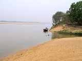
Damodar River originates near Chandwa village, Palamau district, on the Chota Nagpur Plateau
in the Jharkhand
state in eastern India
, and flows eastward for about 592 km through the states of Jharkhand
and West Bengal
to the estaury of the River Hooghly
. It has a number of tributaries and subtributaries, such as Barakar
, Konar
, Bokaro
, Haharo, Jamunia
, Ghari, Guaia, Khadia and Bhera.
In some of the local languages of Jharkhand, Damodar River is called Damuda, damu means sacred and da means water. The Damodar earlier used to flow through Bengal on a direct west to east course and join the River Hughli near Kalna. However, it has changed its course and in its lower reaches most of the water flows into the Mundeswari River
, which combines with other rivers and finally most of the Damodar water flows into the Rupnarayan River
. The remaining mass of water flows through what is known as Damodar into the Hughli south of Kolkata.
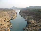
The Barakar is the most important tributary of the Damodar. It originates near Padma in Hazaribagh district and flows through Jharkhand before meeting the Damodar near Dishergarh(Asansol) in West Bengal. The Damodar and the Barakar trifurcates the Chota Nagpur plateau. The rivers pass through hilly areas with great force, sweeping away whatever lies in their path. Two bridges on the Grand Trunk Road
near Barhi in Hazaribagh district were torn down by the Barakar, the great stone bridge in 1913 and the subsequent iron bridge in 1946.
Damodar River was earlier known as the River of Sorrows as it used to flood many areas of Bardhaman
, Hughli
, Howrah and Medinipur districts. Even now the floods sometimes affect the lower Damodar Valley but the havoc it wreaked in earlier years is now a matter of history.
The floods were virtually an annual ritual but in some years the damage was probably more and so many of the great floods of the Damodar are recorded in history – 1770, 1855, 1866, 1873-74, 1875-76, 1884-85, 1891-92, 1897, 1900, 1907, 1913, 1927, 1930, 1935 and 1943. In four of these floods (1770, 1855, 1913 and 1943) most of Bardhaman town was flooded.
In 1789 an agreement was signed between Maharaja Kirti Chand of Burdwan and the East India Company wherein the Maharaja was asked to pay an additional amount of Rs. 1,93,721 for the construction and maintenance of embankment to prevent floods. However, these ran into dispute and in 1866 and 1873, The Bengal Embankment Act was passed, transferring the powers to build and maintain embankment to the government.
 So great was the deavstation every year that the floods passed into folklore, as the following Bhadu
song testifies:
, Koderma
, Giridih
, Dhanbad
, Bokaro
and Chatra
districts in Jharkhand
and Bardhaman
and Hooghly
districts in West Bengal
and partially covers Palamu
, Ranchi
, Lohardaga
and Dumka
districts in Jharkhand and Howrah
, Bankura
and Purulia
districts in West Bengal with a command area of 24,235 km².
The Damodar Valley contains large reserves of coal
and mica
, and the area is a highly developed industrial belt. Many refer to the Damodar Valley as the Ruhr of India because of its similarities with the Ruhr mining-industrial area of Germany. The dams on the Damodar River have several hydroelectric power plants. Of late, the Damodar has become one of the most polluted rivers of India, with chemicals, mine rejects and toxic effluents flowing into the river from mines and industries located in the valley. Efforts are being made to reduce the level of pollution in the river
The Damodar Valley lies in the Chota Nagpur Plateau
of the state of Jharkhand
, India
. It also extends to some parts of the state of West Bengal
. The valley derives its name from the Damodar River, which arises from the plateau of Chota Nagpur. The Damodar Valley is one of the most industrialised parts of India. Three integrated steel plants (Bokaro
, Burnpur
and Durgapur) of Steel Authority of India Limited
(SAIL) and other factories are located in the valley.
Damodar Valley contains a variety of mineral
deposits, including very large deposits of coal
and refractory materials. The largest (almost the only) reserves of coking coal in the country are found in the Jharia coalfields in the valley. The valley also generates 60% of India’s medium grade coal. Coal India Limited
operates in the valley in a big way. Several dam
s have been constructed in the valley
, for the generation of hydroelectric power. The valley is called “the Ruhr
of India”. Damodar Valley Corporation
, popularly known as DVC, came into being on July 7, 1948 by an Act of the Constituent Assembly of India
(Act No. XIV of 1948) as the first multipurpose river valley project of independent India. It is modelled on the Tennessee Valley Authority
of the USA.
The initial focus of the DVC were flood control, irrigation, generation, transmission and distribution of electricity, eco-conservation and afforestation, as well as job creation for the socio-economic well-being of the people residing in and around areas affected by DVC projects. However, over the past few decades, power generation has gained priority. Other objectives of the DVC, however, remain part of its primary responsibility. The dams in the valley have a capacity to moderate peak floods of 650,000 to 250,000 ft3/s. DVC has created irrigation potential of 3640 km2.
The first dam was built across the Barakar River
, a tributary of the Damodar river at Tilaiya
in 1953. The second one was built across the Konar River
, another tributary of the Damodar river at Konar
in 1955. Two dams across the rivers Barakar and Damodar were built at Maithon
in 1957 and Panchet
in 1959. Both the dams are some 8 km upstream of the confluence point of the rivers. These four major dams are controlled by DVC. Durgapur Barrage
was constructed downstream of the four dams in 1955, across the Damodar river at Durgapur in 1955, with head regulators for canals on either side for feeding an extensive system of canals and distributaries. In 1978, the Government of Bihar (that was before the formation of the state of Jharkhand) constructed the Tenughat Dam
across the Damodar river outside the control of DVC. It proposes to construct a dam across the Barakar river at Belpahari in Jharkhand state.
Chota Nagpur Plateau
The Chota Nagpur Plateau is a plateau in eastern India, which covers much of Jharkhand state as well as adjacent parts of Orissa, West Bengal, Bihar and Chhattisgarh. The Indo-Gangetic plain lies to the north and east of the plateau, and the basin of the Mahanadi River lies to the south...
in the Jharkhand
Jharkhand
Jharkhand is a state in eastern India. It was carved out of the southern part of Bihar on 15 November 2000. Jharkhand shares its border with the states of Bihar to the north, Uttar Pradesh and Chhattisgarh to the west, Orissa to the south, and West Bengal to the east...
state in eastern India
India
India , officially the Republic of India , is a country in South Asia. It is the seventh-largest country by geographical area, the second-most populous country with over 1.2 billion people, and the most populous democracy in the world...
, and flows eastward for about 592 km through the states of Jharkhand
Jharkhand
Jharkhand is a state in eastern India. It was carved out of the southern part of Bihar on 15 November 2000. Jharkhand shares its border with the states of Bihar to the north, Uttar Pradesh and Chhattisgarh to the west, Orissa to the south, and West Bengal to the east...
and West Bengal
West Bengal
West Bengal is a state in the eastern region of India and is the nation's fourth-most populous. It is also the seventh-most populous sub-national entity in the world, with over 91 million inhabitants. A major agricultural producer, West Bengal is the sixth-largest contributor to India's GDP...
to the estaury of the River Hooghly
River Hooghly
The Hooghly River or the Bhāgirathi-Hooghly, is an approximately long distributary of the Ganges River in West Bengal, India. It splits from the Ganges as a canal in Murshidabad District at the Farakka Barrage...
. It has a number of tributaries and subtributaries, such as Barakar
Barakar River
The Barakar River is the main tributary of the Damodar River in eastern India. Originating near Padma in Hazaribagh district of Jharkhand it flows for across the northern part of the Chota Nagpur Plateau, mostly in a west to east direction, before joining the Damodar near Dishergarh in Bardhaman...
, Konar
Konar River
The Konar River is a tributary of Damodar River in Hazaribagh and Bokaro districts of the Indian state of Jharkhand.-Course:The Konar originates near Sultana village on the Hazaribagh-Chatra Road.Thereafter, the Konar with its tributary Siwani drains a greater portion of the Hazaribagh plateau,...
, Bokaro
Bokaro River
The Bokaro River flows through the Hazaribagh and Bokaro districts in the Indian state of Jharkhand.-Course:The Bokaro River rises on the Hazaribagh plateau, south of Hazaribagh, but quickly skirts the southern face to pass in a narrow and beautiful valley between Jilinga and Langu Hills.It passes...
, Haharo, Jamunia
Jamunia River
The Jamunia River is a tributary of the Damodar River. It flows through the Hazaribagh, Giridih, Bokaro and Dhanbad districts in the Indian state of Jharkhand.-Course:The Jamunia River rises on the Hazaribagh plateau, near Bishungarh...
, Ghari, Guaia, Khadia and Bhera.
In some of the local languages of Jharkhand, Damodar River is called Damuda, damu means sacred and da means water. The Damodar earlier used to flow through Bengal on a direct west to east course and join the River Hughli near Kalna. However, it has changed its course and in its lower reaches most of the water flows into the Mundeswari River
Mundeswari River
Mundeswari river is a small river in West Bengal which causes floods in Hooghly, Purba Medinipur and Howrah districts during the monsoons. Any discharge above 70,000 ft³/s downstream of Durgapur Barrage may cause flooding depending on the outfall condition of the Mundeswari at Harinkhola...
, which combines with other rivers and finally most of the Damodar water flows into the Rupnarayan River
Rupnarayan River
The Rupnarayan River is a river in India. It begins as the Dhaleswari in the Chhota Nagpur plateau foothills northeast of the town of Purulia. It then follows a tortuous southeasterly course past the town of Bankura, where it is known as the Dwarakeswar river. Near the town of Ghatal it is...
. The remaining mass of water flows through what is known as Damodar into the Hughli south of Kolkata.
The Barakar is the most important tributary of the Damodar. It originates near Padma in Hazaribagh district and flows through Jharkhand before meeting the Damodar near Dishergarh(Asansol) in West Bengal. The Damodar and the Barakar trifurcates the Chota Nagpur plateau. The rivers pass through hilly areas with great force, sweeping away whatever lies in their path. Two bridges on the Grand Trunk Road
Grand Trunk Road
The Grand Trunk Road also formerly known as Uttarapatha, Shah Rah-e-Azam or Sadak-e-Azam or Badshahi Sadak is one of South Asia's oldest and longest major roads...
near Barhi in Hazaribagh district were torn down by the Barakar, the great stone bridge in 1913 and the subsequent iron bridge in 1946.
River of Sorrows
The Chota Nagpur Plateau receives an average annual rainfall of around 1400 mm, almost all of it in the monsoon months between June and August. The huge volume of water that flows down the Damodar and its tributaries during the monsoons used to be a fury in the upper reaches of the valley but in the lower valley it used to overflow its banks and flood large areas.Damodar River was earlier known as the River of Sorrows as it used to flood many areas of Bardhaman
Bardhaman
'Bardhaman or Burdwan , is a city of West Bengal state in eastern India. It is the headquarters of Bardhaman District....
, Hughli
Hooghly District
Hooghly district is one of the districts of the state of West Bengal in India. It can alternatively be spelt Hoogli or Hugli. The district is named after the Hooghly River.The headquarters of the district are at Chinsura...
, Howrah and Medinipur districts. Even now the floods sometimes affect the lower Damodar Valley but the havoc it wreaked in earlier years is now a matter of history.
The floods were virtually an annual ritual but in some years the damage was probably more and so many of the great floods of the Damodar are recorded in history – 1770, 1855, 1866, 1873-74, 1875-76, 1884-85, 1891-92, 1897, 1900, 1907, 1913, 1927, 1930, 1935 and 1943. In four of these floods (1770, 1855, 1913 and 1943) most of Bardhaman town was flooded.
In 1789 an agreement was signed between Maharaja Kirti Chand of Burdwan and the East India Company wherein the Maharaja was asked to pay an additional amount of Rs. 1,93,721 for the construction and maintenance of embankment to prevent floods. However, these ran into dispute and in 1866 and 1873, The Bengal Embankment Act was passed, transferring the powers to build and maintain embankment to the government.
Bhadu (festival)
Bhadu is the social festival of South Bengal. The festival starts from the first day of Bhadro, the fifth month in Bengali Calendar and continues till the end of the month....
song testifies:
- asara maasey chaas koirechhi
- anbo bhadu bhadore.
- damudare baan dekkechhe
- kheya lau nai chole.
- hei damudar pae pori
- tuchka tumi baan kamao.
- bachhor pore bhadu asbek
- lau bukey bhaste dao.
-
- We have sown the crops in Asar
- We will bring Bhadu in Bhadra.
- Floods have swollen the Damodar
- The sailing boats cannot sail.
- O Damodar! We fall at your feet
- Reduce the floods a little.
- Bhadu will come a year later
- Let the boats sail on your surface.
Damodar Valley
The Damodar Valley is spread across HazaribaghHazaribagh District
Hazaribagh district is one of the twenty-four districts of Jharkhand state, India, and Hazaribagh town is the district headquarters. It is currently a part of the Red Corridor.-Etymology:The district is named after its headquarters, the town of Hazaribagh...
, Koderma
Koderma District
Koderma district is one of the twenty-four districts of Jharkhand state, India, and Koderma is the administrative headquarters of this district.Koderma district was created on 10 April 1994, after being carved out of the original Hazaribagh district...
, Giridih
Giridih District
Giridih district is one of the twenty-four districts of Jharkhand state, India, and Giridih is the administrative headquarters of this district. As of 2011 it is the third most populous district of Jharkhand , after Ranchi and Dhanbad.-History:...
, Dhanbad
Dhanbad District
Dhanbad district is one of the twenty-four districts of Jharkhand state, India, and Dhanbad is the administrative headquarters of this district...
, Bokaro
Bokaro District
Bokaro district is one of the twenty-four districts of Jharkhand state, India. It was established in 1991 by carving out one subdivision consisting of two blocks from Dhanbad District and six blocks from Giridih District. Bokaro Steel City is the district headquarters...
and Chatra
Chatra District
Chatra district is one of the twenty-four districts of Jharkhand state, India, and Chatra is the administrative headquarters of this district. The district covers an area of 3706 km². It has a population of 790,680 .-History:...
districts in Jharkhand
Jharkhand
Jharkhand is a state in eastern India. It was carved out of the southern part of Bihar on 15 November 2000. Jharkhand shares its border with the states of Bihar to the north, Uttar Pradesh and Chhattisgarh to the west, Orissa to the south, and West Bengal to the east...
and Bardhaman
Bardhaman District
'Bardhaman district is a district in West Bengal. The headquarter of the district is Bardhaman, though it houses other important industrial towns like Durgapur and Asansol...
and Hooghly
Hooghly District
Hooghly district is one of the districts of the state of West Bengal in India. It can alternatively be spelt Hoogli or Hugli. The district is named after the Hooghly River.The headquarters of the district are at Chinsura...
districts in West Bengal
West Bengal
West Bengal is a state in the eastern region of India and is the nation's fourth-most populous. It is also the seventh-most populous sub-national entity in the world, with over 91 million inhabitants. A major agricultural producer, West Bengal is the sixth-largest contributor to India's GDP...
and partially covers Palamu
Palamu District
Palamau is one of the twenty-four districts of Jharkhand state, India. The district is currently a part of the Red Corridor.-Geography:The district lies between 23°50′ and 24°8′ north latitude and between 83°55′ and 84°30′ east longitude...
, Ranchi
Ranchi District
Ranchi district is one of the twenty-four districts of Jharkhand state in eastern India. Ranchi city, the capital of Jharkhand state is the district headquarters.As of 2011 it is the most populous district of Jharkhand .-Origin of name:...
, Lohardaga
Lohardaga District
Lohardaga district is one of the twenty-four districts of the Indian state of Jharkand. The district is named after the town of Lohardaga, the administrative headquarters of the district. The district was created from a portion of Ranchi district in 1983....
and Dumka
Dumka District
Dumka district is one of the twenty-four districts of Jharkhand state in eastern India, and Dumka is the administrative headquarters of this district. This district covers an area of 3716.02 km². This district has a population of 1,106,521 ....
districts in Jharkhand and Howrah
Howrah District
Howrah district is a district of the West Bengal state in eastern India. It has thousands of years of rich heritage in the form of the great Bengali kingdom of Bhurshut. The district is named after its headquarters, the city of Howrah.-Geography:...
, Bankura
Bankura District
Bankura district is one of the seven districts of Burdwan Division in the Indian state of West Bengal. The district has been described as the “connecting link between the plains of Bengal on the east and Chota Nagpur plateau on the west.” The areas to the east and north-east are low lying alluvial...
and Purulia
Purulia District
Purulia district is one of the nineteen districts of West Bengal state in eastern India. The town of Purulia is the administrative headquarters of the district.-History:...
districts in West Bengal with a command area of 24,235 km².
The Damodar Valley contains large reserves of coal
Coal
Coal is a combustible black or brownish-black sedimentary rock usually occurring in rock strata in layers or veins called coal beds or coal seams. The harder forms, such as anthracite coal, can be regarded as metamorphic rock because of later exposure to elevated temperature and pressure...
and mica
Mica
The mica group of sheet silicate minerals includes several closely related materials having highly perfect basal cleavage. All are monoclinic, with a tendency towards pseudohexagonal crystals, and are similar in chemical composition...
, and the area is a highly developed industrial belt. Many refer to the Damodar Valley as the Ruhr of India because of its similarities with the Ruhr mining-industrial area of Germany. The dams on the Damodar River have several hydroelectric power plants. Of late, the Damodar has become one of the most polluted rivers of India, with chemicals, mine rejects and toxic effluents flowing into the river from mines and industries located in the valley. Efforts are being made to reduce the level of pollution in the river
The Damodar Valley lies in the Chota Nagpur Plateau
Chota Nagpur Plateau
The Chota Nagpur Plateau is a plateau in eastern India, which covers much of Jharkhand state as well as adjacent parts of Orissa, West Bengal, Bihar and Chhattisgarh. The Indo-Gangetic plain lies to the north and east of the plateau, and the basin of the Mahanadi River lies to the south...
of the state of Jharkhand
Jharkhand
Jharkhand is a state in eastern India. It was carved out of the southern part of Bihar on 15 November 2000. Jharkhand shares its border with the states of Bihar to the north, Uttar Pradesh and Chhattisgarh to the west, Orissa to the south, and West Bengal to the east...
, India
India
India , officially the Republic of India , is a country in South Asia. It is the seventh-largest country by geographical area, the second-most populous country with over 1.2 billion people, and the most populous democracy in the world...
. It also extends to some parts of the state of West Bengal
West Bengal
West Bengal is a state in the eastern region of India and is the nation's fourth-most populous. It is also the seventh-most populous sub-national entity in the world, with over 91 million inhabitants. A major agricultural producer, West Bengal is the sixth-largest contributor to India's GDP...
. The valley derives its name from the Damodar River, which arises from the plateau of Chota Nagpur. The Damodar Valley is one of the most industrialised parts of India. Three integrated steel plants (Bokaro
Bokaro Steel City
Bokaro Steel City is one of the largest Industrial city situated in the State of Jharkhand, in India. Bokaro is the 48th cleanest city in India and second in Jharkhand after Jamshedpur and one of the best cities to live in India...
, Burnpur
Burnpur
Burnpur is an important industrial city in Asansol sub-division in the state of West Bengal, India . It is located in Bardhaman District, in the heart of the mining-industrial belt in the western periphery of the state....
and Durgapur) of Steel Authority of India Limited
Steel Authority of India Limited
Steel Authority of India Limited from 116950 The company's current chairman is C.S Verma. With an annual production of 13.5 million metric tons, SAIL is the 14th largest steel producer in the world....
(SAIL) and other factories are located in the valley.
Damodar Valley contains a variety of mineral
Mineral
A mineral is a naturally occurring solid chemical substance formed through biogeochemical processes, having characteristic chemical composition, highly ordered atomic structure, and specific physical properties. By comparison, a rock is an aggregate of minerals and/or mineraloids and does not...
deposits, including very large deposits of coal
Coal
Coal is a combustible black or brownish-black sedimentary rock usually occurring in rock strata in layers or veins called coal beds or coal seams. The harder forms, such as anthracite coal, can be regarded as metamorphic rock because of later exposure to elevated temperature and pressure...
and refractory materials. The largest (almost the only) reserves of coking coal in the country are found in the Jharia coalfields in the valley. The valley also generates 60% of India’s medium grade coal. Coal India Limited
Coal India Limited
Coal India Limited is an Indian state-controlled coal company headquartered in Kolkata, West Bengal, India and the world's largest coal miner with revenue exceeding 60,245 Crore . It was formerly owned entirely by the Union Government of India, under the administrative control of the Ministry of...
operates in the valley in a big way. Several dam
Dam
A dam is a barrier that impounds water or underground streams. Dams generally serve the primary purpose of retaining water, while other structures such as floodgates or levees are used to manage or prevent water flow into specific land regions. Hydropower and pumped-storage hydroelectricity are...
s have been constructed in the valley
Valley
In geology, a valley or dale is a depression with predominant extent in one direction. A very deep river valley may be called a canyon or gorge.The terms U-shaped and V-shaped are descriptive terms of geography to characterize the form of valleys...
, for the generation of hydroelectric power. The valley is called “the Ruhr
Ruhr
The Ruhr is a medium-size river in western Germany , a right tributary of the Rhine.-Description:The source of the Ruhr is near the town of Winterberg in the mountainous Sauerland region, at an elevation of approximately 2,200 feet...
of India”. Damodar Valley Corporation
Damodar Valley Corporation
The Damodar Valley Corporation, popularly known as DVC, is the first multipurpose river valley project of independent India. The corporation came into being on July 7, 1948 by an Act of the Constituent Assembly of India . It is modelled on the Tennessee Valley Authority of the USA. Jawaharlal...
, popularly known as DVC, came into being on July 7, 1948 by an Act of the Constituent Assembly of India
Constituent Assembly of India
The Constituent Assembly of India was elected to write the Constitution of India, and following independence served as the nation's first Parliament.-Nature of the Assembly:...
(Act No. XIV of 1948) as the first multipurpose river valley project of independent India. It is modelled on the Tennessee Valley Authority
Tennessee Valley Authority
The Tennessee Valley Authority is a federally owned corporation in the United States created by congressional charter in May 1933 to provide navigation, flood control, electricity generation, fertilizer manufacturing, and economic development in the Tennessee Valley, a region particularly affected...
of the USA.
The initial focus of the DVC were flood control, irrigation, generation, transmission and distribution of electricity, eco-conservation and afforestation, as well as job creation for the socio-economic well-being of the people residing in and around areas affected by DVC projects. However, over the past few decades, power generation has gained priority. Other objectives of the DVC, however, remain part of its primary responsibility. The dams in the valley have a capacity to moderate peak floods of 650,000 to 250,000 ft3/s. DVC has created irrigation potential of 3640 km2.
The first dam was built across the Barakar River
Barakar River
The Barakar River is the main tributary of the Damodar River in eastern India. Originating near Padma in Hazaribagh district of Jharkhand it flows for across the northern part of the Chota Nagpur Plateau, mostly in a west to east direction, before joining the Damodar near Dishergarh in Bardhaman...
, a tributary of the Damodar river at Tilaiya
Tilaiya
Tilaiya is a town in Koderma district in the Indian state of Jharkhand.-Geography:Tilaiya is located at .-Tilaiya Dam:...
in 1953. The second one was built across the Konar River
Konar River
The Konar River is a tributary of Damodar River in Hazaribagh and Bokaro districts of the Indian state of Jharkhand.-Course:The Konar originates near Sultana village on the Hazaribagh-Chatra Road.Thereafter, the Konar with its tributary Siwani drains a greater portion of the Hazaribagh plateau,...
, another tributary of the Damodar river at Konar
Konar Dam
Konar dam is the second of the four multi-purpose dams included in the first phase of the Damodar Valley Corporation.. It was constructed across the Konar River, a tributary of the Damodar River in Hazaribagh district in the Indian state of Jharkhand and opened in 1955.Konar Dam is long and high...
in 1955. Two dams across the rivers Barakar and Damodar were built at Maithon
Maithon
Maithon is a census town in Dhanbad district in the Indian state of Jharkhand. It is situated on the banks of river Barakar.The name has been derived from Maithan or Mai-Ka-Than or Ma-Er-Than, the "than" being a apa-bhransha or a local pronunciation of Sanskrit/Bangla "Sthan" for "place"...
in 1957 and Panchet
Panchet
Panchet is a census town in Dhanbad district in the Indian state of Jharkhand.-Demographics: India census, Panchet had a population of 8,353. Males constitute 53% of the population and females 47%. Panchet has an average literacy rate of 67%, higher than the national average of 59.5%: male literacy...
in 1959. Both the dams are some 8 km upstream of the confluence point of the rivers. These four major dams are controlled by DVC. Durgapur Barrage
Durgapur Barrage
Durgapur Barrage is across the Damodar River at Durgapur in Bardhaman district in the Indian state of West Bengal.-Overview:The Damodar River Valley Project on the Damodar River and its principal tributary, the...
was constructed downstream of the four dams in 1955, across the Damodar river at Durgapur in 1955, with head regulators for canals on either side for feeding an extensive system of canals and distributaries. In 1978, the Government of Bihar (that was before the formation of the state of Jharkhand) constructed the Tenughat Dam
Tenughat Dam
Tenughat Dam is an earthfill dam with composite masonry cum concrete spillway across the Damodar River at Tenughat in Bokaro district in the Indian state of Jharkhand.-Overview:...
across the Damodar river outside the control of DVC. It proposes to construct a dam across the Barakar river at Belpahari in Jharkhand state.