

DSSAM Model
Encyclopedia
Computer simulation
A computer simulation, a computer model, or a computational model is a computer program, or network of computers, that attempts to simulate an abstract model of a particular system...
developed for the Truckee River
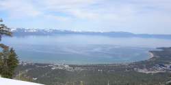
Truckee River
The Truckee River is a stream in the U.S. states of California and Nevada. The river is about long. Its endorheic drainage basin is about , of which about are in Nevada. The Truckee is the sole outlet of Lake Tahoe and drains part of the high Sierra Nevada, emptying into Pyramid Lake in the Great...
to analyze water quality
Water pollution
Water pollution is the contamination of water bodies . Water pollution occurs when pollutants are discharged directly or indirectly into water bodies without adequate treatment to remove harmful compounds....
impacts from land use
Land use
Land use is the human use of land. Land use involves the management and modification of natural environment or wilderness into built environment such as fields, pastures, and settlements. It has also been defined as "the arrangements, activities and inputs people undertake in a certain land cover...
and wastewater
Wastewater
Wastewater is any water that has been adversely affected in quality by anthropogenic influence. It comprises liquid waste discharged by domestic residences, commercial properties, industry, and/or agriculture and can encompass a wide range of potential contaminants and concentrations...
management decisions in the Truckee River Basin. This area includes the cities of Reno
Reno, Nevada
Reno is the county seat of Washoe County, Nevada, United States. The city has a population of about 220,500 and is the most populous Nevada city outside of the Las Vegas metropolitan area...
and Sparks, Nevada
Sparks, Nevada
Sparks is a city in Washoe County, Nevada, United States, located east of Reno, Nevada. The 2010 U.S. Census Bureau population count was 90,264. Sparks is often referred to as half of a twin city .-Geography and Climate:...
as well as the Lake Tahoe
Lake Tahoe
Lake Tahoe is a large freshwater lake in the Sierra Nevada of the United States. At a surface elevation of , it is located along the border between California and Nevada, west of Carson City. Lake Tahoe is the largest alpine lake in North America. Its depth is , making it the USA's second-deepest...
Basin. The model is historically and alternatively called the Earth Metrics Truckee River Model. Since original development in 1984-1986 under contract to the U.S. Environmental Protection Agency
United States Environmental Protection Agency
The U.S. Environmental Protection Agency is an agency of the federal government of the United States charged with protecting human health and the environment, by writing and enforcing regulations based on laws passed by Congress...
(EPA), the model has been refined and successive versions have been dubbed DSSAM II and DSSAM III. This hydrology transport model is based upon a pollutant loading metric called Total maximum daily load
Total Maximum Daily Load
A Total Maximum Daily Load is a regulatory term in the U.S. Clean Water Act, describing a value of the maximum amount of a pollutant that a body of water can receive while still meeting water quality standards...
(TMDL). The success of this flagship model contributed to the Agency’s broadened commitment to the use of the underlying TDML protocol in its national policy for management of most river systems in the United States
United States
The United States of America is a federal constitutional republic comprising fifty states and a federal district...
.
The Truckee River has a length of over 115 miles (185.1 km) and drains an area of approximately 3120 square miles, not counting the extent of its Lake Tahoe
Lake Tahoe
Lake Tahoe is a large freshwater lake in the Sierra Nevada of the United States. At a surface elevation of , it is located along the border between California and Nevada, west of Carson City. Lake Tahoe is the largest alpine lake in North America. Its depth is , making it the USA's second-deepest...
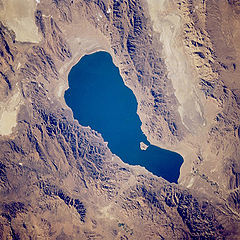
sub-basin. The DSSAM model establishes numerous stations along the entire river extent as well as a considerable number of monitoring points inside the Great Basin
Great Basin
The Great Basin is the largest area of contiguous endorheic watersheds in North America and is noted for its arid conditions and Basin and Range topography that varies from the North American low point at Badwater Basin to the highest point of the contiguous United States, less than away at the...
's Pyramid Lake, the receiving waters of this closed hydrological system. Although the region is sparsely populated, it is important because Lake Tahoe is visited by 20 million persons per annum and Truckee River water quality affects at least two endangered species: the Cui-ui
Cui-ui
The cui-ui, Chasmistes cujus, is a large sucker fish endemic to Pyramid Lake and, prior to its desiccation in the 20th century, Winnemucca Lake in northwestern Nevada. It feeds primarily on zooplankton and possibly on nanoplankton...
sucker fish
Catostomidae
Catostomidae is the sucker family of the order Cypriniformes. There are 80 species in this family of freshwater fishes. Catostomidae are found in North America, east central China, and eastern Siberia...
and the Lahontan cutthroat trout
Lahontan cutthroat trout
Lahontan cutthroat trout is the largest subspecies of cutthroat trout, and the state fish of Nevada.-Natural history:...
.
Development history
Benthic zone
The benthic zone is the ecological region at the lowest level of a body of water such as an ocean or a lake, including the sediment surface and some sub-surface layers. Organisms living in this zone are called benthos. They generally live in close relationship with the substrate bottom; many such...
as well as the topic zone; in the case of Pyramid Lake boats were used to collect grab samples at varying depths and locations. Earth Metrics conducted the software development for the first generation computer model and collected field data on water quality and flow rates in the Truckee River. After model calibration, runs were made to evaluate impacts of alternative land use controls and discharge parameters for treated effluent
Effluent
Effluent is an outflowing of water or gas from a natural body of water, or from a human-made structure.Effluent is defined by the United States Environmental Protection Agency as “wastewater - treated or untreated - that flows out of a treatment plant, sewer, or industrial outfall. Generally refers...
.
The DSSAM Model is constructed to allow dynamic decay of most pollutants; for example, total nitrogen and phosphorus are allowed to be consumed by benthic algae in each time step, and the algal communities are given a separate population dynamic in each river reach (e.g.metabolic rate based upon river temperature). Sources throughout the watershed include non-point agricultural and urban stormwater as well as a multiplicity of point source discharges of treated municipal wastewater effluent.
Subsequent to the first generation of DSSAM model development, calibration and application, later refinements were made. These augmentations to model functionality focussed on increased flexibility in modeling the diel
Diel
People with the surname Diel:* Charles Diel, former head men’s tennis coach at Louisiana State University* Paul Diel , French psychologistDiel may also refer to:* Diel vertical migration, common among deep-sea fish...
cycle and also allowed inclusion of analyzing particulate nitrogen and phosphorus. In developing DSSAM III several changes in the model operation and scope were performed.
Applications
.jpg)
Stormwater
Stormwater is water that originates during precipitation events. It may also be used to apply to water that originates with snowmelt that enters the stormwater system...
runoff, (b) researching agricultural methods for surface runoff
Surface runoff
Surface runoff is the water flow that occurs when soil is infiltrated to full capacity and excess water from rain, meltwater, or other sources flows over the land. This is a major component of the water cycle. Runoff that occurs on surfaces before reaching a channel is also called a nonpoint source...
minimization, (c) innovative solutions for non-point source control and d)engineering aspects of treated wastewater discharge. Regarding stormwater runoff in Washoe County
Washoe County, Nevada
Washoe County is a county located in the U.S. state of Nevada. The population was 421,407 at the 2010 census. Its county seat is Reno. Washoe County includes the Reno-Sparks metropolitan area.-History:...
, the specific elements within a new xeriscape ordinance were analyzed for efficacy using the model. For the varied agricultural uses in the watershed, the model was run to understand the principal sources of adverse impact, and management practices were developed to reduce in river pollution. Use of the model has specifically been conducted to analyze survival of two endangered species
Endangered species
An endangered species is a population of organisms which is at risk of becoming extinct because it is either few in numbers, or threatened by changing environmental or predation parameters...
found in the Truckee River
Truckee River
The Truckee River is a stream in the U.S. states of California and Nevada. The river is about long. Its endorheic drainage basin is about , of which about are in Nevada. The Truckee is the sole outlet of Lake Tahoe and drains part of the high Sierra Nevada, emptying into Pyramid Lake in the Great...
and Pyramid Lake: the Cui-ui
Cui-ui
The cui-ui, Chasmistes cujus, is a large sucker fish endemic to Pyramid Lake and, prior to its desiccation in the 20th century, Winnemucca Lake in northwestern Nevada. It feeds primarily on zooplankton and possibly on nanoplankton...
sucker fish
Catostomidae
Catostomidae is the sucker family of the order Cypriniformes. There are 80 species in this family of freshwater fishes. Catostomidae are found in North America, east central China, and eastern Siberia...
and the Lahontan cutthroat trout
Lahontan cutthroat trout
Lahontan cutthroat trout is the largest subspecies of cutthroat trout, and the state fish of Nevada.-Natural history:...
. When the model is used for surface runoff
Surface runoff
Surface runoff is the water flow that occurs when soil is infiltrated to full capacity and excess water from rain, meltwater, or other sources flows over the land. This is a major component of the water cycle. Runoff that occurs on surfaces before reaching a channel is also called a nonpoint source...
reaching a stream, this pollutant input can be viewed as a line source
Line source
A line source is a source of air, noise, water contamination or electromagnetic radiation that emanates from a linear geometry...
(e.g., a continuous linear source of pollution entering the waterway).