
Cypress Hills Interprovincial Park
Encyclopedia
Cypress Hills Interprovincial Park is an interprovincial park straddling the southern Alberta
-Saskatchewan
border, located southeast of Medicine Hat
. It is Canada
's first and only interprovincial park.
The park consists of two protected areas, the 345 km² (133.2 sq mi) west block, that straddles the Alberta/Saskatchewan border between Alberta Highway 41, the townsite of Elkwater
, Saskatchewan Highway 615
, Saskatchewan Highway 271
and Fort Walsh, and the centre block, an additional area of 58 km² (22.4 sq mi) in Saskatchewan, west of Saskatchewan Highway 21
.
, to a maximum elevation of 1468 metres (4,816 ft), making it Canada's highest point between the Canadian Rockies
and the Labrador peninsula
and also the highest point in Saskatchewan. The "West Block" of the Cypress Hills spans the provincial border. Battle Creek
runs through the central part of the park. Although the hills seem relatively short, in a larger geographic context the plateau does rise gradually from many kilometres away so that the total elevation gain from Medicine Hat is approximately 600 metres.
s.
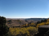
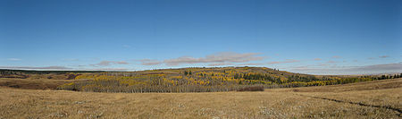
The park protects the majority of the Cypress Hills landscape
, which consists of three separate elevated blocks of lush forest
and fescue grassland
surrounded by dry mixed-grass prairie
. The "west block" and "centre block" are protected as provincial parks, and are managed by Alberta Parks and Protected Areas and Saskatchewan Parks, respectively. The "east block" of the Cypress Hills, situated near Eastend, Saskatchewan, is not part of the park. The Fort Walsh National Historic Site is also located in the park's limits.
species include walleye
, yellow perch
, northern pike
, brook trout
, brown trout
, cutthroat trout
, rainbow trout
, burbot
, common carp
, white sucker
, and shorthead redhorse
.
townsite (a cottage
community sitting at the same elevation as the Banff
townsite), Horseshoe Canyon and Reesor Lake viewpoints (offering 100 km views on a clear day), over 50 km of hiking
and mountain biking
trails, and Hidden Valley Ski Area. Three lakes sit on the Alberta side of the park (Elkwater Lake
, Spruce Coulee Reservoir and Reesor Lake), with another four in Saskatchewan (Harris, Adams, Coulee Lake and Loch Leven).
All year long, park interpreters present education programs to school and youth groups, adult and seniors groups, and a wide range of park visitors.
Alberta
Alberta is a province of Canada. It had an estimated population of 3.7 million in 2010 making it the most populous of Canada's three prairie provinces...
-Saskatchewan
Saskatchewan
Saskatchewan is a prairie province in Canada, which has an area of . Saskatchewan is bordered on the west by Alberta, on the north by the Northwest Territories, on the east by Manitoba, and on the south by the U.S. states of Montana and North Dakota....
border, located southeast of Medicine Hat
Medicine Hat, Alberta
Medicine Hat, known to locals as "The Hat", is a city of 61,097 people located in the southeastern part of the province of Alberta, Canada. It is enclaved within Cypress County along with the nearby Town of Redcliff, although neither is part of the county....
. It is Canada
Canada
Canada is a North American country consisting of ten provinces and three territories. Located in the northern part of the continent, it extends from the Atlantic Ocean in the east to the Pacific Ocean in the west, and northward into the Arctic Ocean...
's first and only interprovincial park.
The park consists of two protected areas, the 345 km² (133.2 sq mi) west block, that straddles the Alberta/Saskatchewan border between Alberta Highway 41, the townsite of Elkwater
Elkwater, Alberta
-External links:*...
, Saskatchewan Highway 615
Saskatchewan Highway 615
Highway 615 is a highway in the Canadian province of Saskatchewan. It runs from Highway 13/Highway 21 near Senate to Highway 271. Highway 615 is about 48 km long....
, Saskatchewan Highway 271
Saskatchewan Highway 271
Highway 271 is a highway in the Canadian province of Saskatchewan. It runs from Highway 21 until Battle Creek Road, Fort Walsh, within the Cypress Hills Interprovincial Park. Highway 271 is about 52 km long....
and Fort Walsh, and the centre block, an additional area of 58 km² (22.4 sq mi) in Saskatchewan, west of Saskatchewan Highway 21
Saskatchewan Highway 21
Highway 21 is a highway in the Canadian province of Saskatchewan. It runs from Montana Secondary Highway 233 at the United States border near Willow Creek to Highway 950/Highway 919 within the Meadow Lake Provincial Park. Highway 21 is about 722 km long.Highway 21 passes through the major...
.
Geography
The Cypress Hills plateau rises up to 200 metres above the surrounding prairiePrairie
Prairies are considered part of the temperate grasslands, savannas, and shrublands biome by ecologists, based on similar temperate climates, moderate rainfall, and grasses, herbs, and shrubs, rather than trees, as the dominant vegetation type...
, to a maximum elevation of 1468 metres (4,816 ft), making it Canada's highest point between the Canadian Rockies
Canadian Rockies
The Canadian Rockies comprise the Canadian segment of the North American Rocky Mountains range. They are the eastern part of the Canadian Cordillera, extending from the Interior Plains of Alberta to the Rocky Mountain Trench of British Columbia. The southern end borders Idaho and Montana of the USA...
and the Labrador peninsula
Labrador Peninsula
The Labrador Peninsula is a large peninsula in eastern Canada. It is bounded by the Hudson Bay to the west, the Hudson Strait to the north, the Labrador Sea to the east, and the Gulf of Saint Lawrence to the south-east...
and also the highest point in Saskatchewan. The "West Block" of the Cypress Hills spans the provincial border. Battle Creek
Battle Creek (Milk River)
Battle Creek is a stream that begins in southeastern Alberta along the border with Saskatchewan, in the Cypress Hills Interprovincial Park.It flows into the Milk River in Blaine County, Montana...
runs through the central part of the park. Although the hills seem relatively short, in a larger geographic context the plateau does rise gradually from many kilometres away so that the total elevation gain from Medicine Hat is approximately 600 metres.
Nature
Approximately 700 species of plants and animals thrive in the park, including 14 species of orchidOrchidaceae
The Orchidaceae, commonly referred to as the orchid family, is a morphologically diverse and widespread family of monocots in the order Asparagales. Along with the Asteraceae, it is one of the two largest families of flowering plants, with between 21,950 and 26,049 currently accepted species,...
s.
The park protects the majority of the Cypress Hills landscape
Landscape
Landscape comprises the visible features of an area of land, including the physical elements of landforms such as mountains, hills, water bodies such as rivers, lakes, ponds and the sea, living elements of land cover including indigenous vegetation, human elements including different forms of...
, which consists of three separate elevated blocks of lush forest
Forest
A forest, also referred to as a wood or the woods, is an area with a high density of trees. As with cities, depending where you are in the world, what is considered a forest may vary significantly in size and have various classification according to how and what of the forest is composed...
and fescue grassland
Grassland
Grasslands are areas where the vegetation is dominated by grasses and other herbaceous plants . However, sedge and rush families can also be found. Grasslands occur naturally on all continents except Antarctica...
surrounded by dry mixed-grass prairie
Prairie
Prairies are considered part of the temperate grasslands, savannas, and shrublands biome by ecologists, based on similar temperate climates, moderate rainfall, and grasses, herbs, and shrubs, rather than trees, as the dominant vegetation type...
. The "west block" and "centre block" are protected as provincial parks, and are managed by Alberta Parks and Protected Areas and Saskatchewan Parks, respectively. The "east block" of the Cypress Hills, situated near Eastend, Saskatchewan, is not part of the park. The Fort Walsh National Historic Site is also located in the park's limits.
Fish species
FishFish
Fish are a paraphyletic group of organisms that consist of all gill-bearing aquatic vertebrate animals that lack limbs with digits. Included in this definition are the living hagfish, lampreys, and cartilaginous and bony fish, as well as various extinct related groups...
species include walleye
Walleye
Walleye is a freshwater perciform fish native to most of Canada and to the northern United States. It is a North American close relative of the European pikeperch...
, yellow perch
Yellow perch
The yellow perch is a species of perch found in the United States and Canada, where it is often referred to by the shortform perch. Yellow perch look similar to the European perch, but are paler and more yellowish, with less red in the fins. They have six to eight dark, vertical bars on their sides...
, northern pike
Northern Pike
The northern pike , is a species of carnivorous fish of the genus Esox...
, brook trout
Brook trout
The brook trout, Salvelinus fontinalis, is a species of fish in the salmon family of order Salmoniformes. In many parts of its range, it is known as the speckled trout or squaretail. A potamodromous population in Lake Superior are known as coaster trout or, simply, as coasters...
, brown trout
Brown trout
The brown trout and the sea trout are fish of the same species....
, cutthroat trout
Cutthroat trout
The cutthroat trout is a species of freshwater fish in the salmon family of order Salmoniformes. It is one of the many fish species colloquially known as trout...
, rainbow trout
Rainbow trout
The rainbow trout is a species of salmonid native to tributaries of the Pacific Ocean in Asia and North America. The steelhead is a sea run rainbow trout usually returning to freshwater to spawn after 2 to 3 years at sea. In other words, rainbow trout and steelhead trout are the same species....
, burbot
Burbot
The burbot is the only gadiform fish inhabiting freshwaters. It is also known as mariah, the lawyer, and eelpout. It is closely related to the marine common ling and the cusk...
, common carp
Common carp
The Common carp is a widespread freshwater fish of eutrophic waters in lakes and large rivers in Europe and Asia. The wild populations are considered vulnerable to extinction, but the species has also been domesticated and introduced into environments worldwide, and is often considered an invasive...
, white sucker
White Sucker
The White Sucker is a bottom-feeding freshwater fish inhabiting North America from Labrador in the north to Georgia and New Mexico in the south. It is a long, round-bodied fish with a dark green, grey, copper, brown, or black back and sides and a light underbelly. When fullgrown, it is between 12...
, and shorthead redhorse
Shorthead redhorse
-Introduction:The Shorthead Redhorse is a wide-ranging species in North America that needs to be monitored throughout its range. The Shorthead Redhorse is native to central and eastern North America. However, its range has expanded to include areas like the Hudson estuary and Grayson County, Texas...
.
Activities
On the Alberta side of the west block, key park features include Head of the Mountain, the ElkwaterElkwater, Alberta
-External links:*...
townsite (a cottage
Cottage
__toc__In modern usage, a cottage is usually a modest, often cozy dwelling, typically in a rural or semi-rural location. However there are cottage-style dwellings in cities, and in places such as Canada the term exists with no connotations of size at all...
community sitting at the same elevation as the Banff
Banff, Alberta
Banff is a town within Banff National Park in Alberta, Canada. It is located in Alberta's Rockies along the Trans-Canada Highway, approximately west of Calgary and east of Lake Louise....
townsite), Horseshoe Canyon and Reesor Lake viewpoints (offering 100 km views on a clear day), over 50 km of hiking
Hiking
Hiking is an outdoor activity which consists of walking in natural environments, often in mountainous or other scenic terrain. People often hike on hiking trails. It is such a popular activity that there are numerous hiking organizations worldwide. The health benefits of different types of hiking...
and mountain biking
Mountain biking
Mountain biking is a sport which consists of riding bicycles off-road, often over rough terrain, using specially adapted mountain bikes. Mountain bikes share similarities with other bikes, but incorporate features designed to enhance durability and performance in rough terrain.Mountain biking can...
trails, and Hidden Valley Ski Area. Three lakes sit on the Alberta side of the park (Elkwater Lake
Elkwater Lake (Alberta)
Elkwater Lake is a small lake in southeastern Alberta, Canada.It is located in the northwest corner of the Cypress Hills Interprovincial Park, along the Buffalo Trail...
, Spruce Coulee Reservoir and Reesor Lake), with another four in Saskatchewan (Harris, Adams, Coulee Lake and Loch Leven).
All year long, park interpreters present education programs to school and youth groups, adult and seniors groups, and a wide range of park visitors.
History
- 1951 - The Cypress Hills Provincial Park was established in Alberta.
- 1989 - On August 25, the governments of Alberta and Saskatchewan signed an agreement committing themselves to cooperation on ecosystemEcosystemAn ecosystem is a biological environment consisting of all the organisms living in a particular area, as well as all the nonliving , physical components of the environment with which the organisms interact, such as air, soil, water and sunlight....
management, education and park promotion. - 2000 - Fort Walsh National Historic Site (located on the Saskatchewan side of the West Block) joined the collective. Together, these three partner agencies make up the park. Both Alberta and Saskatchewan provincial governments signed the Cypress Hills Interprovincial Park agreement, establishing the first interprovincial park in Canada.
- 2004 - On September 28, Saskatchewan Parks, Alberta Community Development and Parks Canada signed an agreement that declared the park a dark-sky preserve.
See also
- List of Alberta provincial parks
- List of Saskatchewan parks
- List of Canadian provincial parks
- List of National Parks of Canada
- List of highest points of Canadian provinces and territories