
Cyclone Mala
Encyclopedia
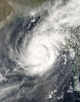
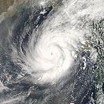
Cyclone Mala, also known as Very Severe Cyclonic Storm Mala, was the strongest tropical cyclone of the 2006 North Indian Ocean cyclone season. The equivalent of a Category 4 hurricane on the Saffir-Simpson Hurricane Scale
, the storm was the strongest named cyclone in the Bay of Bengal at the time, as Cyclone Sidr
was stronger in the 2007 season (though several stronger unnamed storms have existed.) Mala struck the coast of Burma with winds of 115 mph (185 km/h), causing $6.7 million (2006 USD
) in damages and at least 22 deaths. Its minimum central pressure was 954 hPa
(mbar). The next cyclone to hit Burma was Nargis
in 2008, which was slightly weaker, but had a significantly greater impact. The name Mala is Sinhalese as well as Hindi for a garland of flowers.
in mid- to late-April, and organized around a low level circulation on April 23. Under light low-level shear, convection built around the system, and consolidated around the center. The area continued to organize, and was upgraded by RSMC New Delhi to Deep Depression on the 25th. The deep depression moved to the northwest, and intensified into a Cyclonic Storm Mala later that day.
Steering currents were initially weak, and due to moderate southeasterly shear Mala remained a Cyclonic Storm. After drifting to the north, a trough of low pressure caused the storm to accelerate to the northeast. The shear diminished, and continued favorable conditions allowed Mala to intensify into a Severe Cyclonic Storm on April 27. Outflow became better defined as the eyewall contracted, and on the 28th Mala rapidly intensified to a 100-110kt (184–202 km/h) Very Severe Cyclonic Storm with an estimated central pressure of 954hPa according to the IMD; the JTWC estimated a peak of 140 mph, making it the first Category 4 cyclone recorded in this basin in the 21st century. The cyclone weakened shortly after peaking in intensity, and struck Gwa
, a city 190 km (118.1 mi) to the northwest of Yangon
in the Rakhine State
with winds of 115 mph. The storm rapidly weakened over land, and quickly dissipated after landfall.
Bangladesh
issued storm warnings for the southern portion of the country, though an actual landfall was never forecast. 34,000 members of the Bangladesh Red Crescent Society
were put on standby for the possible impact on the country. In addition, hundreds of fisherman returned to land after storm warnings were raised.
Also, Thailand
's Meteorological Department warned citizens for the threat of severe flooding in eight northwestern provinces.
China Meteorological Agency warned that the outer rainbands of Mala might affect Yunnan province as early as April 27. Two days later, forecasters expected rainy weather to spread across the whole province with rainstorm in southern part.
 Prior to making landfall, Mala sent powerful waves up the coastline of Burma. Near the landfall area, 88 houses were completely destroyed, while 1,246 were damaged to some degree. 75% of all of the structures in Gwa Township were damaged. Temporary shelters following the storm included a monastery, two schools, and a meditation center. Throughout the Burma coastline, four people were killed. In addition, the offshore island of Haingyi experienced damage.
Heavy rainfall in the northern Ayeyarwady Division
killed eighteen people, with fourteen missing. The area most affected by Mala was the city of Yangon
. There, the strong winds tore the roofs of several buildings, with over 150 buildings being damaged. The industrial area faced severe damage as well. There, two factories were destroyed, while the powerful winds shattered windows on numerous buildings. The winds also downed numerous power lines, leaving many without electricity. Heavy rainfall in the city clogged storm drains, leaving some downtown areas in 1 metre (3 feet) of water. Throughout Burma, the cyclone killed 22 people and caused damage to over 6,000 houses, of which 351 were completely destroyed.
Saffir-Simpson Hurricane Scale
The Saffir–Simpson Hurricane Scale , or the Saffir–Simpson Hurricane Wind Scale , classifies hurricanes — Western Hemisphere tropical cyclones that exceed the intensities of tropical depressions and tropical storms — into five categories distinguished by the intensities of their sustained winds...
, the storm was the strongest named cyclone in the Bay of Bengal at the time, as Cyclone Sidr
Cyclone Sidr
Cyclone Sidr was the strongest named cyclone in the Bay of Bengal...
was stronger in the 2007 season (though several stronger unnamed storms have existed.) Mala struck the coast of Burma with winds of 115 mph (185 km/h), causing $6.7 million (2006 USD
United States dollar
The United States dollar , also referred to as the American dollar, is the official currency of the United States of America. It is divided into 100 smaller units called cents or pennies....
) in damages and at least 22 deaths. Its minimum central pressure was 954 hPa
HPA
-Organizations:*Halifax Port Authority, a port authority in Canada*Hamburg Port Authority, the port authority for the Port of Hamburg, Germany*Health Protection Agency, a health organization in the United Kingdom...
(mbar). The next cyclone to hit Burma was Nargis
Cyclone Nargis
Cyclone Nargis , was a strong tropical cyclone that caused the worst natural disaster in the recorded history of Burma. The cyclone made landfall in Burma on Friday, May 2, 2008, causing catastrophic destruction and at least 138,000 fatalities...
in 2008, which was slightly weaker, but had a significantly greater impact. The name Mala is Sinhalese as well as Hindi for a garland of flowers.
Meteorological history
An area of convection persisted over the southern Bay of BengalBay of Bengal
The Bay of Bengal , the largest bay in the world, forms the northeastern part of the Indian Ocean. It resembles a triangle in shape, and is bordered mostly by the Eastern Coast of India, southern coast of Bangladesh and Sri Lanka to the west and Burma and the Andaman and Nicobar Islands to the...
in mid- to late-April, and organized around a low level circulation on April 23. Under light low-level shear, convection built around the system, and consolidated around the center. The area continued to organize, and was upgraded by RSMC New Delhi to Deep Depression on the 25th. The deep depression moved to the northwest, and intensified into a Cyclonic Storm Mala later that day.
Steering currents were initially weak, and due to moderate southeasterly shear Mala remained a Cyclonic Storm. After drifting to the north, a trough of low pressure caused the storm to accelerate to the northeast. The shear diminished, and continued favorable conditions allowed Mala to intensify into a Severe Cyclonic Storm on April 27. Outflow became better defined as the eyewall contracted, and on the 28th Mala rapidly intensified to a 100-110kt (184–202 km/h) Very Severe Cyclonic Storm with an estimated central pressure of 954hPa according to the IMD; the JTWC estimated a peak of 140 mph, making it the first Category 4 cyclone recorded in this basin in the 21st century. The cyclone weakened shortly after peaking in intensity, and struck Gwa
GWA
GWA may stand for:* Genome-wide association study* George Walton Academy, a college preparatory school.* Georgia Writers Association* God's Wife of Amun* Google Web Accelerator, a software utility* GWA International Limited, an Australian company...
, a city 190 km (118.1 mi) to the northwest of Yangon
Yangon
Yangon is a former capital of Burma and the capital of Yangon Region . Although the military government has officially relocated the capital to Naypyidaw since March 2006, Yangon, with a population of over four million, continues to be the country's largest city and the most important commercial...
in the Rakhine State
Rakhine State
Rakhine State is a Burmese state. Situated on the western coast, it is bordered by Chin State in the north, Magway Region, Bago Region and Ayeyarwady Region in the east, the Bay of Bengal to the west, and the Chittagong Division of Bangladesh to the northwest. It is located approximately between...
with winds of 115 mph. The storm rapidly weakened over land, and quickly dissipated after landfall.
Preparations
In preparation for the storm, Burma officials evacuated 50,000 people from the coastline. Storm warnings began on Burma's radio system three days prior to landfall.Bangladesh
Bangladesh
Bangladesh , officially the People's Republic of Bangladesh is a sovereign state located in South Asia. It is bordered by India on all sides except for a small border with Burma to the far southeast and by the Bay of Bengal to the south...
issued storm warnings for the southern portion of the country, though an actual landfall was never forecast. 34,000 members of the Bangladesh Red Crescent Society
Bangladesh Red Crescent Society
Bangladesh Red Crescent Society was established in 1973. It has its headquarters in Dhaka.-External links:**...
were put on standby for the possible impact on the country. In addition, hundreds of fisherman returned to land after storm warnings were raised.
Also, Thailand
Thailand
Thailand , officially the Kingdom of Thailand , formerly known as Siam , is a country located at the centre of the Indochina peninsula and Southeast Asia. It is bordered to the north by Burma and Laos, to the east by Laos and Cambodia, to the south by the Gulf of Thailand and Malaysia, and to the...
's Meteorological Department warned citizens for the threat of severe flooding in eight northwestern provinces.
China Meteorological Agency warned that the outer rainbands of Mala might affect Yunnan province as early as April 27. Two days later, forecasters expected rainy weather to spread across the whole province with rainstorm in southern part.
Impact
Heavy rainfall in the northern Ayeyarwady Division
Ayeyarwady Division
Ayeyarwady Region is a region of Myanmar, occupying the delta region of the Ayeyarwady River . It is bordered by Bago Region to the north, Bago Region and Yangon Region to the east, and the Bay of Bengal to the south and west...
killed eighteen people, with fourteen missing. The area most affected by Mala was the city of Yangon
Yangon
Yangon is a former capital of Burma and the capital of Yangon Region . Although the military government has officially relocated the capital to Naypyidaw since March 2006, Yangon, with a population of over four million, continues to be the country's largest city and the most important commercial...
. There, the strong winds tore the roofs of several buildings, with over 150 buildings being damaged. The industrial area faced severe damage as well. There, two factories were destroyed, while the powerful winds shattered windows on numerous buildings. The winds also downed numerous power lines, leaving many without electricity. Heavy rainfall in the city clogged storm drains, leaving some downtown areas in 1 metre (3 feet) of water. Throughout Burma, the cyclone killed 22 people and caused damage to over 6,000 houses, of which 351 were completely destroyed.