
Cyclone Gonu
Encyclopedia
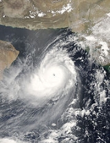
Cyclone Gonu is the strongest tropical cyclone
on record in the Arabian Sea
, and is also the strongest named cyclone in the northern Indian Ocean. The second named tropical cyclone of the 2007 North Indian Ocean cyclone season, Gonu developed from a persistent area of convection
in the eastern Arabian Sea on June 1. With a favorable upper-level environment and warm sea surface temperature
s, it rapidly intensified
to attain peak winds of 240 km/h (150 mph) on June 3, to the India Meteorological Department
. Gonu weakened after encountering dry air and cooler waters, and early on June 6, it made landfall
on the eastern-most tip of Oman
, becoming the strongest tropical cyclone to hit the Arabian Peninsula
. It then turned northward into the Gulf of Oman
, and dissipated on June 7 after making landfall in southern Iran
.
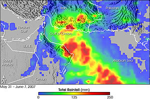
Intense tropical cyclones like Gonu are extremely rare over the Arabian Sea, since most storms in this area tend to be small and dissipate quickly. The cyclone caused 50 deaths and about $4.2 billion in damage (2007 USD) in Oman, where the cyclone was considered the nation's worst natural disaster. Gonu dropped heavy rainfall near the eastern coastline, reaching up to 610 mm (24 inches), which caused flooding and heavy damage. In Iran, the cyclone caused 28 deaths and $ in damage (2007 USD).
spawned a low pressure area
in the eastern Arabian Sea
. By May 31, an organized tropical disturbance was located about 645 km (400 mi) south of Mumbai
, India, with cyclonic convection, or thunderstorm activity, and a well-defined mid-level circulation. The disturbance initially lacked a distinct low-level circulation; instead it consisted of strong divergence along the western end of a surface trough
of low pressure. A favorable upper-level environment allowed convection to improve, and by late on June 1, the system developed to the extent that the India Meteorological Department
(IMD) classified it as a depression. It tracked westward along the southwestern periphery of a mid-level ridge
over southern India. Convection continued to organize, and early on June 2 the Joint Typhoon Warning Center
(JTWC) classified it Tropical Cyclone 02A about 685 km (425 mi) southwest of Mumbai.
Upon first forming, the system contended with the entrainment
of dry air to the northwest of the storm, which was expected to limit intensification. The storm steadily intensified, and early on June 2 the IMD upgraded it to deep depression status. Later in the day the IMD classified the system as Cyclonic Storm Gonu about 760 km (470 mi) southwest of Mumbai, India. As a mid-latitude trough developed over Pakistan, Gonu turned to the north and northeast, though it resumed a westward track after ridging built to the north of the storm. With a solid area of intense convection, it rapidly intensified
to attain severe cyclonic status early on June 3, and with good outflow
the JTWC upgraded it to the equivalent of a minimal hurricane. The dry air ultimately had a smaller impact on the intensification than previously estimated. A well-defined eye
developed in the center of convection
, and after moving over a local increase in ocean heat content, Gonu rapidly deepened.
 Late on June 3, the IMD upgraded the storm to Very Severe Cyclonic Storm Gonu. With low amounts of vertical wind shear
and favorable upper-level outflow, Gonu strengthened further to attain peak 1-min sustained winds of 270 km/h (165 mph) and gusts to 315 km/h (195 mph), about 285 km (175 mi) east-southeast of Masirah Island
on the coast of Oman. The IMD upgraded it to Super Cyclonic Storm Gonu late on June 4, with peak 3-min sustained winds reaching 240 km/h (150 mph) and an estimated pressure
of 920 mbar.
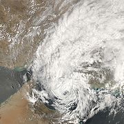
After the storm maintained peak winds for about six hours, the IMD downgraded Gonu to very severe cyclonic storm status late on June 4. Its eye became cloud-filled and ragged, and the cyclone gradually weakened due to cooler water temperatures and drier air as it approached the Arabian Peninsula
. Due to land interaction with Oman, the inner core of deep convection rapidly weakened, and over a period of 24 hours the intensity decreased by 95 km/h (60 mph). According to the IMD, Cyclone Gonu crossed the eastern-most tip of Oman still as a very severe cyclonic storm early on June 6. Although the winds continued to gradually decrease, overall organization increased slightly in the hours prior to landfall; Gonu maintained a well-defined low-level structure with a weak eye.
After emerging into the Gulf of Oman
, the cyclone briefly re-intensified slightly. However, increasing wind shear and entrainment of dry air from the Arabian Peninsula
continued to remove deep convection from its eastern semicircle. On June 6, the cyclone turned to the north-northwest, and later that day the JTWC downgraded Gonu to tropical storm status. The IMD followed suit by downgrading Gonu to severe cyclonic storm status and later to cyclonic storm status early on June 7. Gonu crossed the Makran
coast in Iran six hours later and the IMD stopped issuing advisories on the cyclone.
, remarked the nation had already developed a contingency plan, which included the activation of army and police personnel after the storm's passage. Significant damage was expected, especially in northeastern areas, along with up to 150 mm (6 in) of rainfall and very strong winds. Officials recommended citizens evacuate from potentially affected areas, and about 7,000 people were forced to leave Masirah Island
due to the threat of high surf and strong winds. Overall, more than 20,000 people evacuated to emergency shelters. A state of emergency
was declared for the nation. The Omani national weather service warned that the cyclone was expected to be worse than the destructive cyclone that hit Masirah Island in 1977. The Mina al Fahal
oil terminal closed for over three days due to the threat of the storm. Omani officials closed government offices for two days and declared a five-day long national holiday. Most businesses near the coastline were closed prior to the announcement. Authorities at the Seeb International Airport
delayed all flights after 2000 UTC
on June 5 due to the cyclone.
 In Saudi Arabia and the United Arab Emirates, both members of OPEC
, no official warnings had been issued due to Gonu. The storm was not expected to disrupt oil supplies from these two nations. However, oil prices rose early on June 5 because of concerns of disruptions caused by Gonu, as well as the threat of nationwide strikes in Nigeria
, Africa's biggest oil producer. Crude oil for July delivery rose $1.13, or 1.7 percent, to $66.21 Monday on the New York Mercantile Exchange
, the highest close in 15 days. Futures reached $66.48, the highest intraday price since April 30. The contract was at $65.95 a barrel, down 26 cents, in after-hours electronic trading at Tuesday in Singapore
. Tom Kloza, chief oil analyst at the Oil Price Information Service, said he doubted the increase could be attributed to Gonu. "I don't know if you can really attribute any of the gain to the cyclone," he said. "It's an excuse, as opposed to a reason, for the rise in prices."
In Pakistan, officials recommended fishermen remain within 50 km (30 mi) of the coastline, due to anticipated rough waves in the open ocean. Naval authorities in the United States warned ships to avoid the cyclone in the Arabian Sea.
The Iran Department of Meteorology declared storm warnings for the country's southeastern coastline; the agency anticipated moderate to severe precipitation and gusty winds. Prior to the arrival of the cyclone, about 40,000 people, including around 4,000 students at the International University of Chabahar
, evacuated coastal areas of the country to at least 1 km (0.6 mi) inland. All flights in and out of the Konarak Airport
were canceled during a 48-hour period. Additionally, all hospitals in Sistan and Baluchestan Province were put on red alert. The Iran chapter
of the Red Cross
advanced the delivery of necessary relief supplies.
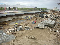 Across its path, Cyclone Gonu caused heavy damage and many fatalities. About seven hours before passing near the northeastern Oman coastline, Cyclone Gonu began affecting the country with rough winds and heavy precipitation; rainfall totals reached near the coast. Gonu produced strong waves along much of the coastline, leaving many coastal roads flooded. There was a 5.1 meter (17 foot) storm surge
and a 200 m (660 ft) incursion of seawater inland at Ras al-Hadd; other areas along the coast had similar levels.
and the village of Ras al Hadd
at the easternmost point of the Omani mainland. In Muscat
, winds reached 100 km/h (62 mph), leaving the capital city without power. Strong waves and heavy rainfall flooded streets and some buildings. Police workers in the city sent text messages to keep people away from flooded streets to prevent electrocutions. Little damage was reported to the oil fields of the nation. The liquefied natural gas
terminal in Sur, which handles 10 million tonnes of gas each year, was badly hit by the storm and could not be operated. Overall, the cyclone killed 50 people in the country; by the fourth day after it struck the country, 27 people had been reported missing. Around 20,000 people were affected, and damage in the country was estimated at around $4.2 billion (2007 USD).
of the United Arab Emirates
, forcing roads to be closed and traffic diverted. Civil defence and police were on duty to manage the road closures, while municipal workers pumped the excess water off the roads. The road connecting Kalba
and Fujairah was closed due to the road being submerged by water. The waves along the coastline were reported to be 10 m (32 ft) high, which destroyed about a dozen fishing boats. About 300 boats were moved from the water or emptied of equipment, and overall damage to the port of Fujairah was reported as severe. A boat sank by the port, leaving its ten passengers missing.
. Winds reached 111 km/h (69 mph), which caused power outages and damaged some homes made of clay; the power outage led to some fires across the city. The rainfall flooded at least 40 houses, and resulted in the temporary closure of several major roads. Cyclone Gonu produced a storm tide
of 2 m (6.5 ft) in some locations, with many homes near the coastline receiving damage. In Bandar-e-gaz
, heavy rainfall overflowed a river, killing three people in a vehicle caught in the water. Flooding from the rainfall also destroyed a dam in Nikshahr County
. Throughout the country, the cyclone caused 28 deaths, including 20 from drowning; damage in Iran was estimated at 2 billion (2007 IRR
, $216 million 2007 USD).
till Gwadar
. Cyclone Gonu passed through the Sur Bandar village in Pakistan
which is located near the sea side of Gwadar
city. The cyclone was reported to have sunk a number of boats off the eastern coast of Gwadar. It was feared that fishing launches that had ventured into the open sea may have been stranded. According to reports, the tropical cyclone also caused damage to dozens of boats anchored at the coast. However, no loss of life had been reported. Gonu caused torrential rain and high winds along Pakistan's Arabian Sea coast. At least three houses and one school were destroyed and 210 anchored fishing boats were badly damaged in the coastal town of Sar Bandar in Baluchistan province
– an oceanographic
phenomenon that involves the replacement of the nutrient
-depleted surface water with deeper nutrient-rich water; the passage caused a significant increase in phytoplankton
. Additionally, the cyclone delayed the arrival of the Indian Ocean south-west monsoon in the Western Ghats
in India.
In Oman, production of desalinated water
was interrupted, as both of Oman's desalination plants failed. The first, Ghubrah, lost supplies of natural gas
, halting production; while the second, Barka, sustained a damaged switchgear due to flooding. These plants provided water to Muscat's 631,000 residents and surrounding areas, triggering severe water shortages across eastern Oman. To rectify the situation, officials used water tanks. The water returned to near normal in five days, as the two plants returned to service. Additionally, electricians worked quickly to repair the power outages across the region. Five days after Gonu hit, utilities were restored to most of Muscat and the coastal provinces. The Omani army assisted residents in returning to their houses. Even though the Omani government did not request any international aid, the United States offered assistance through naval ships
in the area; this was eventually rejected. The country lost an estimated $200 million (2007 USD) in oil exports. In the months after the storm, the government allocated funds for the removal of debris and trees, as well as restoration of roads in tourist areas. Additionally, the National Committee for Civil Defence set up 139 buildings to provide temporary housing for 8,192 people. Services such as water and electricity were gradually restored, and people returned to their homes. By two weeks after the storm's passage, most of those remaining in shelters were from Qurayat
, one of the most severely affected villages.
After the passage of the cyclone, the Iran chapter of the Red Cross and its volunteers worked in conjunction with the military to distribute relief supplies to villages using trucks and helicopters. The branch in Sistan and Baluchestan Province distributed over 10,000 blankets, 1,300 tents, 400 clothing items, 82,000 loaves of bread, and 87,000 bottles of water to affected citizens. In total, 61,558 families received aid from the Red Cross in Iran. The Iranian government provided monetary relief to the affected people. Officials worked to restore roads, bridges, and power systems in the affected areas, although repairs were more difficult in some locations; by a week after the storm, several villages remained surrounded by floodwaters.
Cyclone Gonu set several intensity records. When it became a very severe cyclonic storm on June 3, Gonu became the strongest tropical cyclone on record in the Arabian Sea
. Later, it became the only super cyclonic storm, which is a tropical cyclone with 3-min sustained winds of at least 220 km/h (140 mph), in the region. The JTWC estimated peak winds of 270 km/h (165 mph). Based on their estimate, Gonu was tied with the 1991 Bangladesh Cyclone
for the strongest tropical cyclone in the entire northern Indian Ocean, and had the highest windspeed of any cyclone in this basin. On June 6, Gonu made landfall
in extreme eastern Oman with winds of 150 km/h (90 mph), making it the strongest tropical cyclone on record to strike the Arabian Peninsula. With a damage total of $4.2 billion (2007 USD) and 50 deaths, Gonu became the worst natural disaster on record in Oman. Additionally, the storm was only the second cyclonic storm on record to strike Iran, the other doing so on June 4, 1898.
Tropical cyclone
A tropical cyclone is a storm system characterized by a large low-pressure center and numerous thunderstorms that produce strong winds and heavy rain. Tropical cyclones strengthen when water evaporated from the ocean is released as the saturated air rises, resulting in condensation of water vapor...
on record in the Arabian Sea
Arabian Sea
The Arabian Sea is a region of the Indian Ocean bounded on the east by India, on the north by Pakistan and Iran, on the west by the Arabian Peninsula, on the south, approximately, by a line between Cape Guardafui in northeastern Somalia and Kanyakumari in India...
, and is also the strongest named cyclone in the northern Indian Ocean. The second named tropical cyclone of the 2007 North Indian Ocean cyclone season, Gonu developed from a persistent area of convection
Convection
Convection is the movement of molecules within fluids and rheids. It cannot take place in solids, since neither bulk current flows nor significant diffusion can take place in solids....
in the eastern Arabian Sea on June 1. With a favorable upper-level environment and warm sea surface temperature
Sea surface temperature
Sea surface temperature is the water temperature close to the oceans surface. The exact meaning of surface varies according to the measurement method used, but it is between and below the sea surface. Air masses in the Earth's atmosphere are highly modified by sea surface temperatures within a...
s, it rapidly intensified
Rapid deepening
Rapid deepening, also known as rapid intensification, is a meteorological condition that occurs when the minimum sea-level atmospheric pressure of a tropical cyclone decreases drastically in a short period of time. The National Weather Service describes rapid deepening as a decrease of...
to attain peak winds of 240 km/h (150 mph) on June 3, to the India Meteorological Department
India Meteorological Department
The India Meteorological Department , also referred to as the Met Office, is an agency of the Ministry of Earth Sciences of the Government of India. It is the principal agency responsible for meteorological observations, weather forecasting and seismology...
. Gonu weakened after encountering dry air and cooler waters, and early on June 6, it made landfall
Landfall (meteorology)
Landfall is the event of a tropical cyclone or a waterspout coming onto land after being over water. When a waterspout makes landfall it is reclassified as a tornado, which can then cause damage inland...
on the eastern-most tip of Oman
Oman
Oman , officially called the Sultanate of Oman , is an Arab state in southwest Asia on the southeast coast of the Arabian Peninsula. It is bordered by the United Arab Emirates to the northwest, Saudi Arabia to the west, and Yemen to the southwest. The coast is formed by the Arabian Sea on the...
, becoming the strongest tropical cyclone to hit the Arabian Peninsula
Arabian Peninsula
The Arabian Peninsula is a land mass situated north-east of Africa. Also known as Arabia or the Arabian subcontinent, it is the world's largest peninsula and covers 3,237,500 km2...
. It then turned northward into the Gulf of Oman
Gulf of Oman
The Gulf of Oman or Sea of Oman is a strait that connects the Arabian Sea with the Strait of Hormuz, which then runs to the Persian Gulf. It is generally included as a branch of the Persian Gulf, not as an arm of the Arabian Sea. On the north coast is Pakistan and Iran...
, and dissipated on June 7 after making landfall in southern Iran
Iran
Iran , officially the Islamic Republic of Iran , is a country in Southern and Western Asia. The name "Iran" has been in use natively since the Sassanian era and came into use internationally in 1935, before which the country was known to the Western world as Persia...
.
Intense tropical cyclones like Gonu are extremely rare over the Arabian Sea, since most storms in this area tend to be small and dissipate quickly. The cyclone caused 50 deaths and about $4.2 billion in damage (2007 USD) in Oman, where the cyclone was considered the nation's worst natural disaster. Gonu dropped heavy rainfall near the eastern coastline, reaching up to 610 mm (24 inches), which caused flooding and heavy damage. In Iran, the cyclone caused 28 deaths and $ in damage (2007 USD).
Meteorological history
Toward the end of May 2007, the monsoon troughMonsoon trough
The monsoon trough is that portion of the Intertropical Convergence Zone which extends into or through a monsoon circulation, as depicted by a line on a weather map showing the locations of minimum sea level pressure, and as such, is a convergence zone between the wind patterns of the southern and...
spawned a low pressure area
Low pressure area
A low-pressure area, or "low", is a region where the atmospheric pressure at sea level is below that of surrounding locations. Low-pressure systems form under areas of wind divergence which occur in upper levels of the troposphere. The formation process of a low-pressure area is known as...
in the eastern Arabian Sea
Arabian Sea
The Arabian Sea is a region of the Indian Ocean bounded on the east by India, on the north by Pakistan and Iran, on the west by the Arabian Peninsula, on the south, approximately, by a line between Cape Guardafui in northeastern Somalia and Kanyakumari in India...
. By May 31, an organized tropical disturbance was located about 645 km (400 mi) south of Mumbai
Mumbai
Mumbai , formerly known as Bombay in English, is the capital of the Indian state of Maharashtra. It is the most populous city in India, and the fourth most populous city in the world, with a total metropolitan area population of approximately 20.5 million...
, India, with cyclonic convection, or thunderstorm activity, and a well-defined mid-level circulation. The disturbance initially lacked a distinct low-level circulation; instead it consisted of strong divergence along the western end of a surface trough
Trough (meteorology)
A trough is an elongated region of relatively low atmospheric pressure, often associated with fronts.Unlike fronts, there is not a universal symbol for a trough on a weather chart. The weather charts in some countries or regions mark troughs by a line. In the United States, a trough may be marked...
of low pressure. A favorable upper-level environment allowed convection to improve, and by late on June 1, the system developed to the extent that the India Meteorological Department
India Meteorological Department
The India Meteorological Department , also referred to as the Met Office, is an agency of the Ministry of Earth Sciences of the Government of India. It is the principal agency responsible for meteorological observations, weather forecasting and seismology...
(IMD) classified it as a depression. It tracked westward along the southwestern periphery of a mid-level ridge
Ridge (meteorology)
A ridge is an elongated region of relatively high atmospheric pressure, the opposite of a trough....
over southern India. Convection continued to organize, and early on June 2 the Joint Typhoon Warning Center
Joint Typhoon Warning Center
The Joint Typhoon Warning Center is a joint United States Navy – United States Air Force task force located at the Naval Maritime Forecast Center in Pearl Harbor, Hawaii...
(JTWC) classified it Tropical Cyclone 02A about 685 km (425 mi) southwest of Mumbai.
Upon first forming, the system contended with the entrainment
Entrainment (meteorology)
Entrainment is a phenomenon of the atmosphere which occurs when a turbulent flow captures a non-turbulent flow. It is typically used to refer to the capture of a wind flow of high moisture content, or in the case of tropical cyclones, the capture of drier air....
of dry air to the northwest of the storm, which was expected to limit intensification. The storm steadily intensified, and early on June 2 the IMD upgraded it to deep depression status. Later in the day the IMD classified the system as Cyclonic Storm Gonu about 760 km (470 mi) southwest of Mumbai, India. As a mid-latitude trough developed over Pakistan, Gonu turned to the north and northeast, though it resumed a westward track after ridging built to the north of the storm. With a solid area of intense convection, it rapidly intensified
Rapid deepening
Rapid deepening, also known as rapid intensification, is a meteorological condition that occurs when the minimum sea-level atmospheric pressure of a tropical cyclone decreases drastically in a short period of time. The National Weather Service describes rapid deepening as a decrease of...
to attain severe cyclonic status early on June 3, and with good outflow
Outflow (meteorology)
Outflow, in meteorology, is air that flows outwards from a storm system. It is associated with ridging, or anticyclonic flow. In the low levels of the troposphere, outflow radiates from thunderstorms in the form of a wedge of rain-cooled air, which is visible as a thin rope-like cloud on weather...
the JTWC upgraded it to the equivalent of a minimal hurricane. The dry air ultimately had a smaller impact on the intensification than previously estimated. A well-defined eye
Eye (cyclone)
The eye is a region of mostly calm weather found at the center of strong tropical cyclones. The eye of a storm is a roughly circular area and typically 30–65 km in diameter. It is surrounded by the eyewall, a ring of towering thunderstorms where the second most severe weather of a cyclone...
developed in the center of convection
Convection
Convection is the movement of molecules within fluids and rheids. It cannot take place in solids, since neither bulk current flows nor significant diffusion can take place in solids....
, and after moving over a local increase in ocean heat content, Gonu rapidly deepened.
Wind shear
Wind shear, sometimes referred to as windshear or wind gradient, is a difference in wind speed and direction over a relatively short distance in the atmosphere...
and favorable upper-level outflow, Gonu strengthened further to attain peak 1-min sustained winds of 270 km/h (165 mph) and gusts to 315 km/h (195 mph), about 285 km (175 mi) east-southeast of Masirah Island
Masirah Island
Masirah is an island off the East coast of Oman, 95 km long north-south, between 12 and 14 km wide, with an area of about 649 km², and a population estimated at 12,000 in 12 villages mainly in the north of the island...
on the coast of Oman. The IMD upgraded it to Super Cyclonic Storm Gonu late on June 4, with peak 3-min sustained winds reaching 240 km/h (150 mph) and an estimated pressure
Atmospheric pressure
Atmospheric pressure is the force per unit area exerted into a surface by the weight of air above that surface in the atmosphere of Earth . In most circumstances atmospheric pressure is closely approximated by the hydrostatic pressure caused by the weight of air above the measurement point...
of 920 mbar.
After the storm maintained peak winds for about six hours, the IMD downgraded Gonu to very severe cyclonic storm status late on June 4. Its eye became cloud-filled and ragged, and the cyclone gradually weakened due to cooler water temperatures and drier air as it approached the Arabian Peninsula
Arabian Peninsula
The Arabian Peninsula is a land mass situated north-east of Africa. Also known as Arabia or the Arabian subcontinent, it is the world's largest peninsula and covers 3,237,500 km2...
. Due to land interaction with Oman, the inner core of deep convection rapidly weakened, and over a period of 24 hours the intensity decreased by 95 km/h (60 mph). According to the IMD, Cyclone Gonu crossed the eastern-most tip of Oman still as a very severe cyclonic storm early on June 6. Although the winds continued to gradually decrease, overall organization increased slightly in the hours prior to landfall; Gonu maintained a well-defined low-level structure with a weak eye.
After emerging into the Gulf of Oman
Gulf of Oman
The Gulf of Oman or Sea of Oman is a strait that connects the Arabian Sea with the Strait of Hormuz, which then runs to the Persian Gulf. It is generally included as a branch of the Persian Gulf, not as an arm of the Arabian Sea. On the north coast is Pakistan and Iran...
, the cyclone briefly re-intensified slightly. However, increasing wind shear and entrainment of dry air from the Arabian Peninsula
Arabian Peninsula
The Arabian Peninsula is a land mass situated north-east of Africa. Also known as Arabia or the Arabian subcontinent, it is the world's largest peninsula and covers 3,237,500 km2...
continued to remove deep convection from its eastern semicircle. On June 6, the cyclone turned to the north-northwest, and later that day the JTWC downgraded Gonu to tropical storm status. The IMD followed suit by downgrading Gonu to severe cyclonic storm status and later to cyclonic storm status early on June 7. Gonu crossed the Makran
Makran
The present day Makran is a semi-desert coastal strip in the south of Sindh, Balochistan, in Iran and Pakistan, along the coast of the Arabian Sea and the Gulf of Oman. The present day Makran derived its name from Maka, a satrap of Achaemenid Empire....
coast in Iran six hours later and the IMD stopped issuing advisories on the cyclone.
Preparations
The Oman Chairman of the National Committee for Civil Defence, General Malek Bin Sulaiman Al Ma'amariMalek Bin Sulaiman Al Ma'amari
General Malek Bin Sulaiman Al Ma'amari is an Omani military and political figure. He was the chairman of the National Committee for Civil Defence until he got retired by Sultan Qaboos during 2011 Omani protests....
, remarked the nation had already developed a contingency plan, which included the activation of army and police personnel after the storm's passage. Significant damage was expected, especially in northeastern areas, along with up to 150 mm (6 in) of rainfall and very strong winds. Officials recommended citizens evacuate from potentially affected areas, and about 7,000 people were forced to leave Masirah Island
Masirah Island
Masirah is an island off the East coast of Oman, 95 km long north-south, between 12 and 14 km wide, with an area of about 649 km², and a population estimated at 12,000 in 12 villages mainly in the north of the island...
due to the threat of high surf and strong winds. Overall, more than 20,000 people evacuated to emergency shelters. A state of emergency
State of emergency
A state of emergency is a governmental declaration that may suspend some normal functions of the executive, legislative and judicial powers, alert citizens to change their normal behaviours, or order government agencies to implement emergency preparedness plans. It can also be used as a rationale...
was declared for the nation. The Omani national weather service warned that the cyclone was expected to be worse than the destructive cyclone that hit Masirah Island in 1977. The Mina al Fahal
Mina al Fahal
Mina al Fahal is a coastal area in the northeast of Oman, near to the country's capital, Muscat. It was renamed from Saih al Maleh as the petroleum processing plant was developed. It is a key area for the country's petroleum operations. Petroleum Development Oman is based at Mina al Fahal, and...
oil terminal closed for over three days due to the threat of the storm. Omani officials closed government offices for two days and declared a five-day long national holiday. Most businesses near the coastline were closed prior to the announcement. Authorities at the Seeb International Airport
Seeb International Airport
Muscat International Airport is the main airport in Muscat, Oman. It is the hub for the national carrier Oman Air. The distance from Old Muscat is 30 km and it is 15 km from the main residential localities. At the moment the airport is being expanded and modernized...
delayed all flights after 2000 UTC
Coordinated Universal Time
Coordinated Universal Time is the primary time standard by which the world regulates clocks and time. It is one of several closely related successors to Greenwich Mean Time. Computer servers, online services and other entities that rely on having a universally accepted time use UTC for that purpose...
on June 5 due to the cyclone.
OPEC
OPEC is an intergovernmental organization of twelve developing countries made up of Algeria, Angola, Ecuador, Iran, Iraq, Kuwait, Libya, Nigeria, Qatar, Saudi Arabia, the United Arab Emirates, and Venezuela. OPEC has maintained its headquarters in Vienna since 1965, and hosts regular meetings...
, no official warnings had been issued due to Gonu. The storm was not expected to disrupt oil supplies from these two nations. However, oil prices rose early on June 5 because of concerns of disruptions caused by Gonu, as well as the threat of nationwide strikes in Nigeria
Nigeria
Nigeria , officially the Federal Republic of Nigeria, is a federal constitutional republic comprising 36 states and its Federal Capital Territory, Abuja. The country is located in West Africa and shares land borders with the Republic of Benin in the west, Chad and Cameroon in the east, and Niger in...
, Africa's biggest oil producer. Crude oil for July delivery rose $1.13, or 1.7 percent, to $66.21 Monday on the New York Mercantile Exchange
New York Mercantile Exchange
The New York Mercantile Exchange is the world's largest physical commodity futures exchange. It is located at One North End Avenue in the World Financial Center in the Battery Park City section of Manhattan, New York City...
, the highest close in 15 days. Futures reached $66.48, the highest intraday price since April 30. The contract was at $65.95 a barrel, down 26 cents, in after-hours electronic trading at Tuesday in Singapore
Singapore
Singapore , officially the Republic of Singapore, is a Southeast Asian city-state off the southern tip of the Malay Peninsula, north of the equator. An island country made up of 63 islands, it is separated from Malaysia by the Straits of Johor to its north and from Indonesia's Riau Islands by the...
. Tom Kloza, chief oil analyst at the Oil Price Information Service, said he doubted the increase could be attributed to Gonu. "I don't know if you can really attribute any of the gain to the cyclone," he said. "It's an excuse, as opposed to a reason, for the rise in prices."
In Pakistan, officials recommended fishermen remain within 50 km (30 mi) of the coastline, due to anticipated rough waves in the open ocean. Naval authorities in the United States warned ships to avoid the cyclone in the Arabian Sea.
The Iran Department of Meteorology declared storm warnings for the country's southeastern coastline; the agency anticipated moderate to severe precipitation and gusty winds. Prior to the arrival of the cyclone, about 40,000 people, including around 4,000 students at the International University of Chabahar
International University of Chabahar
International University of Chabahar , is located in the Chabahar Free Trade-Industrial Zone, in the city of Chabahar, part of Sistan and Baluchestan Province in Iran.-Affiliates:...
, evacuated coastal areas of the country to at least 1 km (0.6 mi) inland. All flights in and out of the Konarak Airport
Konarak Airport
Konarak Airport is an airport in Chabahar, Iran .-Airlines and destinations:...
were canceled during a 48-hour period. Additionally, all hospitals in Sistan and Baluchestan Province were put on red alert. The Iran chapter
Red Crescent Society of the Islamic Republic of Iran
Red Crescent Society of the Islamic Republic of Iran was formed in 1923 as the name of Red Lion and Sun Society of Iran. It was changed to the Red Crescent society after the Islamic Revolution and has its headquarters in Tehran.-Wikileaks Report:...
of the Red Cross
International Red Cross and Red Crescent Movement
The International Red Cross and Red Crescent Movement is an international humanitarian movement with approximately 97 million volunteers, members and staff worldwide which was founded to protect human life and health, to ensure respect for all human beings, and to prevent and alleviate human...
advanced the delivery of necessary relief supplies.
Impact
Storm surge
A storm surge is an offshore rise of water associated with a low pressure weather system, typically tropical cyclones and strong extratropical cyclones. Storm surges are caused primarily by high winds pushing on the ocean's surface. The wind causes the water to pile up higher than the ordinary sea...
and a 200 m (660 ft) incursion of seawater inland at Ras al-Hadd; other areas along the coast had similar levels.
Oman
Strong winds knocked out power and telephone lines across the eastern region of the country, leaving thousands isolated until the lines were repaired hours later. The cyclone caused extensive damage along the coastline, including in the city of SurSur, Oman
Sur is a capital city of Ash Sharqiyah Region, northeastern Oman, on the coast of the Gulf of Oman. It is located at around , and is 93 miles southeast of the Omani capital Muscat. Historically the city is known for being an important destination point for sailors...
and the village of Ras al Hadd
Ras al hadd
Ras al Hadd is a village in Ash Sharqiyah district in Oman. It is considered the last point in the East of Oman and is located in the conjunction between Gulf of Oman and Arabian Sea...
at the easternmost point of the Omani mainland. In Muscat
Muscat, Oman
Muscat is the capital of Oman. It is also the seat of government and largest city in the Governorate of Muscat. As of 2008, the population of the Muscat metropolitan area was 1,090,797. The metropolitan area spans approximately and includes six provinces called wilayats...
, winds reached 100 km/h (62 mph), leaving the capital city without power. Strong waves and heavy rainfall flooded streets and some buildings. Police workers in the city sent text messages to keep people away from flooded streets to prevent electrocutions. Little damage was reported to the oil fields of the nation. The liquefied natural gas
Liquefied natural gas
Liquefied natural gas or LNG is natural gas that has been converted temporarily to liquid form for ease of storage or transport....
terminal in Sur, which handles 10 million tonnes of gas each year, was badly hit by the storm and could not be operated. Overall, the cyclone killed 50 people in the country; by the fourth day after it struck the country, 27 people had been reported missing. Around 20,000 people were affected, and damage in the country was estimated at around $4.2 billion (2007 USD).
United Arab Emirates
Fierce waves pushed large amounts of water to coastal areas in FujairahFujairah
Fujairah is one of the seven emirates that make up the United Arab Emirates, and the only one on the Gulf of Oman in the country's east instead of Persian Gulf .-History:...
of the United Arab Emirates
United Arab Emirates
The United Arab Emirates, abbreviated as the UAE, or shortened to "the Emirates", is a state situated in the southeast of the Arabian Peninsula in Western Asia on the Persian Gulf, bordering Oman, and Saudi Arabia, and sharing sea borders with Iraq, Kuwait, Bahrain, Qatar, and Iran.The UAE is a...
, forcing roads to be closed and traffic diverted. Civil defence and police were on duty to manage the road closures, while municipal workers pumped the excess water off the roads. The road connecting Kalba
Kalba
Kalba is a city in the United Arab Emirates. It is an enclave of the emirate of Sharjah, Kalba is north of Oman and south of the emirate of Fujairah. Khor Kalba , a mangrove swamp, is located further south of the town. The town was captured by the Portuguese Empire in the 16th century and was...
and Fujairah was closed due to the road being submerged by water. The waves along the coastline were reported to be 10 m (32 ft) high, which destroyed about a dozen fishing boats. About 300 boats were moved from the water or emptied of equipment, and overall damage to the port of Fujairah was reported as severe. A boat sank by the port, leaving its ten passengers missing.
Iran
Upon striking Iran, Gonu dropped moderate to heavy rainfall, including 74 mm (2.91 in) in the city of ChabaharChabahar
Chah Bahar is a city in and capital of Chah Bahar County, Sistan and Baluchestan Province, Iran. Chah Bahar is a free port on the coast of the Gulf of Oman. At the 2006 census, its population was 71,070, in 13,837 families...
. Winds reached 111 km/h (69 mph), which caused power outages and damaged some homes made of clay; the power outage led to some fires across the city. The rainfall flooded at least 40 houses, and resulted in the temporary closure of several major roads. Cyclone Gonu produced a storm tide
Storm tide
A storm tide is a tide with a high flood period caused by a storm. Storm tides can be a severe danger to the coast and the people living along the coast. The water level can rise to more than 5 meters above the normal tide....
of 2 m (6.5 ft) in some locations, with many homes near the coastline receiving damage. In Bandar-e-gaz
Bandar-e-gaz County
Bandar-e-Gaz County is a county in Golestan Province in Iran. The capital of the county is Bandar Gaz. At the 2006 census, the county's population was 46,179, in 12,059 families. The county has two districts: Now Kandeh District and Central District...
, heavy rainfall overflowed a river, killing three people in a vehicle caught in the water. Flooding from the rainfall also destroyed a dam in Nikshahr County
Nikshahr County
Nikshahr County is a county in Sistan and Baluchestan Province in Iran. The capital of the county is Nik Shahr. At the 2006 census, the county's population was 185,355, in 37,858 families. The county is subdivided into five districts: the Central District, Bent District, Fanuj District, Qasr-e...
. Throughout the country, the cyclone caused 28 deaths, including 20 from drowning; damage in Iran was estimated at 2 billion (2007 IRR
Iranian rial
The rial is the currency of Iran. It is subdivided into 100 dinar but, because of the very low current value of the rial, no fraction of the rial is used in accounting....
, $216 million 2007 USD).
Pakistan
Cyclone Gonu caused strong gusty winds along the Pakistani coast with rainfall reported from KarachiKarachi
Karachi is the largest city, main seaport and the main financial centre of Pakistan, as well as the capital of the province of Sindh. The city has an estimated population of 13 to 15 million, while the total metropolitan area has a population of over 18 million...
till Gwadar
Gwadar
Gwadar also known as Godar is a developing port city on the southwestern Arabian Sea coast of Pakistan. It is the district headquarters of Gwadar District in Balochistan province and has a population of approximately 50,000.Gwadar is strategically located at the apex of the Arabian Sea and at the...
. Cyclone Gonu passed through the Sur Bandar village in Pakistan
Pakistan
Pakistan , officially the Islamic Republic of Pakistan is a sovereign state in South Asia. It has a coastline along the Arabian Sea and the Gulf of Oman in the south and is bordered by Afghanistan and Iran in the west, India in the east and China in the far northeast. In the north, Tajikistan...
which is located near the sea side of Gwadar
Gwadar
Gwadar also known as Godar is a developing port city on the southwestern Arabian Sea coast of Pakistan. It is the district headquarters of Gwadar District in Balochistan province and has a population of approximately 50,000.Gwadar is strategically located at the apex of the Arabian Sea and at the...
city. The cyclone was reported to have sunk a number of boats off the eastern coast of Gwadar. It was feared that fishing launches that had ventured into the open sea may have been stranded. According to reports, the tropical cyclone also caused damage to dozens of boats anchored at the coast. However, no loss of life had been reported. Gonu caused torrential rain and high winds along Pakistan's Arabian Sea coast. At least three houses and one school were destroyed and 210 anchored fishing boats were badly damaged in the coastal town of Sar Bandar in Baluchistan province
Aftermath and records
The Muscat International Airport reopened after three days while Fujairah reopened on June 7 after it was closed the day before. The cyclone caused little impact to oil facilities along its path; after the initial price rises, oil dropped over USD2 per barrel as a result. Across the northern Arabian Sea, the passage of Gonu produced stronger winds and significant upwellingUpwelling
Upwelling is an oceanographic phenomenon that involves wind-driven motion of dense, cooler, and usually nutrient-rich water towards the ocean surface, replacing the warmer, usually nutrient-depleted surface water. The increased availability in upwelling regions results in high levels of primary...
– an oceanographic
Physical oceanography
Physical oceanography is the study of physical conditions and physical processes within the ocean, especially the motions and physical properties of ocean waters.Physical oceanography is one of several sub-domains into which oceanography is divided...
phenomenon that involves the replacement of the nutrient
Nutrient
A nutrient is a chemical that an organism needs to live and grow or a substance used in an organism's metabolism which must be taken in from its environment. They are used to build and repair tissues, regulate body processes and are converted to and used as energy...
-depleted surface water with deeper nutrient-rich water; the passage caused a significant increase in phytoplankton
Phytoplankton
Phytoplankton are the autotrophic component of the plankton community. The name comes from the Greek words φυτόν , meaning "plant", and πλαγκτός , meaning "wanderer" or "drifter". Most phytoplankton are too small to be individually seen with the unaided eye...
. Additionally, the cyclone delayed the arrival of the Indian Ocean south-west monsoon in the Western Ghats
Western Ghats
The Western Ghats, Western Ghauts or the Sahyādri is a mountain range along the western side of India. It runs north to south along the western edge of the Deccan Plateau, and separates the plateau from a narrow coastal plain along the Arabian Sea. The Western Ghats block rainfall to the Deccan...
in India.
In Oman, production of desalinated water
Desalination
Desalination, desalinization, or desalinisation refers to any of several processes that remove some amount of salt and other minerals from saline water...
was interrupted, as both of Oman's desalination plants failed. The first, Ghubrah, lost supplies of natural gas
Natural gas
Natural gas is a naturally occurring gas mixture consisting primarily of methane, typically with 0–20% higher hydrocarbons . It is found associated with other hydrocarbon fuel, in coal beds, as methane clathrates, and is an important fuel source and a major feedstock for fertilizers.Most natural...
, halting production; while the second, Barka, sustained a damaged switchgear due to flooding. These plants provided water to Muscat's 631,000 residents and surrounding areas, triggering severe water shortages across eastern Oman. To rectify the situation, officials used water tanks. The water returned to near normal in five days, as the two plants returned to service. Additionally, electricians worked quickly to repair the power outages across the region. Five days after Gonu hit, utilities were restored to most of Muscat and the coastal provinces. The Omani army assisted residents in returning to their houses. Even though the Omani government did not request any international aid, the United States offered assistance through naval ships
United States Navy
The United States Navy is the naval warfare service branch of the United States Armed Forces and one of the seven uniformed services of the United States. The U.S. Navy is the largest in the world; its battle fleet tonnage is greater than that of the next 13 largest navies combined. The U.S...
in the area; this was eventually rejected. The country lost an estimated $200 million (2007 USD) in oil exports. In the months after the storm, the government allocated funds for the removal of debris and trees, as well as restoration of roads in tourist areas. Additionally, the National Committee for Civil Defence set up 139 buildings to provide temporary housing for 8,192 people. Services such as water and electricity were gradually restored, and people returned to their homes. By two weeks after the storm's passage, most of those remaining in shelters were from Qurayat
Qurayyat, Oman
Qurayyat is a small fishing village near Muscat, Oman. A popular stopping point on the way to Sur, Qurayyat is in itself also a very popular destination for Muscat.-External links:*...
, one of the most severely affected villages.
After the passage of the cyclone, the Iran chapter of the Red Cross and its volunteers worked in conjunction with the military to distribute relief supplies to villages using trucks and helicopters. The branch in Sistan and Baluchestan Province distributed over 10,000 blankets, 1,300 tents, 400 clothing items, 82,000 loaves of bread, and 87,000 bottles of water to affected citizens. In total, 61,558 families received aid from the Red Cross in Iran. The Iranian government provided monetary relief to the affected people. Officials worked to restore roads, bridges, and power systems in the affected areas, although repairs were more difficult in some locations; by a week after the storm, several villages remained surrounded by floodwaters.
Cyclone Gonu set several intensity records. When it became a very severe cyclonic storm on June 3, Gonu became the strongest tropical cyclone on record in the Arabian Sea
Arabian Sea
The Arabian Sea is a region of the Indian Ocean bounded on the east by India, on the north by Pakistan and Iran, on the west by the Arabian Peninsula, on the south, approximately, by a line between Cape Guardafui in northeastern Somalia and Kanyakumari in India...
. Later, it became the only super cyclonic storm, which is a tropical cyclone with 3-min sustained winds of at least 220 km/h (140 mph), in the region. The JTWC estimated peak winds of 270 km/h (165 mph). Based on their estimate, Gonu was tied with the 1991 Bangladesh Cyclone
1991 Bangladesh cyclone
-External links:** from NIRAPAD disaster response organisation.**...
for the strongest tropical cyclone in the entire northern Indian Ocean, and had the highest windspeed of any cyclone in this basin. On June 6, Gonu made landfall
Landfall (meteorology)
Landfall is the event of a tropical cyclone or a waterspout coming onto land after being over water. When a waterspout makes landfall it is reclassified as a tornado, which can then cause damage inland...
in extreme eastern Oman with winds of 150 km/h (90 mph), making it the strongest tropical cyclone on record to strike the Arabian Peninsula. With a damage total of $4.2 billion (2007 USD) and 50 deaths, Gonu became the worst natural disaster on record in Oman. Additionally, the storm was only the second cyclonic storm on record to strike Iran, the other doing so on June 4, 1898.
See also
- List of most intense tropical cyclones
- Timeline of the 2007 North Indian Ocean cyclone seasonTimeline of the 2007 North Indian Ocean cyclone seasonBelow is a timeline of the 2007 North Indian Ocean cyclone season, documenting major events with regards to tropical cyclone formation, strengthening, weakening, landfall, extratropical transition, as well as dissipation...
- Geography of OmanGeography of OmanOman is a country situated in Southwest Asia, bordering the Arabian Sea, Gulf of Oman, and Persian Gulf, between Yemen and United Arab Emirates .-Location:...
- Cyclone PhetCyclone PhetCyclone Phet was the third named cyclone of the 2010 North Indian Ocean cyclone season. Phet developed from a low pressure area in the Arabian Sea that organized into a tropical cyclone on May 31...
External links
- India Meteorological Department
- Pakistan Meteorological Department
- Joint Typhoon Warning Center
- History of past cyclones in the Arabian Sea (IMD)
- CIMSS Satellite Blog
- Anomalies in Meterological
[sic Fields over Northern Asia and it's[sic] Impact on Hurricane Gonu]