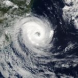
All Topics  
Cyclone Catarina

 
Cyclone Catarina

   Email Print
   Bookmark   Link


Cyclone Catarina


Cyclone Catarina is one of several informal names for a South Atlantic tropical cyclone
South Atlantic tropical cyclone

A South Atlantic tropical cyclone is an unusual weather event. Strong wind shear and a lack of weather disturbances favorable for tropical cyclone development make any hurricane-strength cyclones extremely rare....
 that hit southeastern Brazil
Brazil

Brazil , officially the Federative Republic of Brazil , is a country in South America. It is the List of countries and outlying territories by total area country by geographical area, occupying nearly half of South America, the List of countries by population country, and the fourth most populous democracy in the world....
 in late March 2004. The storm developed out of a stationary cold-core
Surface weather analysis

Surface weather analysis is a special type of weather map that provides a view of weather elements over a geographical area at a specified time based on information from ground-based weather stations....
 upper-level trough
Trough (meteorology)

A trough is an elongated region of relatively low atmospheric pressure, often associated with weather fronts.Unlike fronts, there is not a universal symbol for a trough on a weather chart....
 on March 12. Almost a week later, on March 19, a disturbance developed along the trough and traveled towards the east-southeast until March 22 when a ridge
Ridge (meteorology)

A ridge is an elongated region of relatively high atmospheric pressure, the opposite of a Trough .See also* Geopotential height* Block ...
 caused the forward motion of the disturbance to cease.


Discussion
Ask a question about 'Cyclone Catarina'
Start a new discussion about 'Cyclone Catarina'
Answer questions from other users
Full Discussion Forum


Encyclopedia


Cyclone Catarina is one of several informal names for a South Atlantic tropical cyclone
South Atlantic tropical cyclone

A South Atlantic tropical cyclone is an unusual weather event. Strong wind shear and a lack of weather disturbances favorable for tropical cyclone development make any hurricane-strength cyclones extremely rare....
 that hit southeastern Brazil
Brazil

Brazil , officially the Federative Republic of Brazil , is a country in South America. It is the List of countries and outlying territories by total area country by geographical area, occupying nearly half of South America, the List of countries by population country, and the fourth most populous democracy in the world....
 in late March 2004. The storm developed out of a stationary cold-core
Surface weather analysis

Surface weather analysis is a special type of weather map that provides a view of weather elements over a geographical area at a specified time based on information from ground-based weather stations....
 upper-level trough
Trough (meteorology)

A trough is an elongated region of relatively low atmospheric pressure, often associated with weather fronts.Unlike fronts, there is not a universal symbol for a trough on a weather chart....
 on March 12. Almost a week later, on March 19, a disturbance developed along the trough and traveled towards the east-southeast until March 22 when a ridge
Ridge (meteorology)

A ridge is an elongated region of relatively high atmospheric pressure, the opposite of a Trough .See also* Geopotential height* Block ...
 caused the forward motion of the disturbance to cease. The disturbance was in an unusually favorable environment with below average wind shear
Wind shear

Wind shear, sometimes referred to as windshear or wind gradient, is a difference in wind wind speed and wind direction over a relatively short distance in the Earth's atmosphere....
 and above average sea surface temperatures. The combination of the two led to a slow transition from an Extratropical cyclone
Extratropical cyclone

Extratropical cyclones, sometimes called mid-latitude cyclones or wave cyclones, are a group of cyclones defined as Synoptic scale meteorology Low pressure area weather systems that occur in the middle latitudes of the Earth having neither tropical cyclone nor polar cyclone characteristics, and are connected with Surface weath...
 to a Subtropical cyclone
Subtropical cyclone

A subtropical cyclone is a weather system that has some characteristics of a tropical cyclone and some characteristics of an extratropical cyclone....
 by March 24. The storm continued to obtain tropical characteristics
Tropical cyclogenesis

Tropical cyclogenesis is the technical term describing the development and strengthening of a tropical cyclone in the atmosphere. The mechanisms through which tropical cyclogenesis occurs are distinctly different from those through which mid-latitude cyclogenesis occurs....
 and became a tropical storm
Tropical cyclone

A tropical cyclone is a storm characterized by a large low pressure system center and numerous thunderstorms that produce strong winds and flooding rain....
 the next day while the winds steadily increased. The storm reached winds of 75 mph (120 km/h)—equivalent to a low-end category one hurricane on the Saffir-Simpson Hurricane Scale
Saffir-Simpson Hurricane Scale

The Saffir-Simpson Hurricane Scale is a classification used for most Western Hemisphere tropical cyclones that exceed the intensities of tropical depressions and tropical storms, and thereby become hurricanes....
—on March 26. At this time it was unofficially named Catarina and was also the first hurricane-intensity tropical cyclone ever recorded in the Southern Atlantic Ocean. Unusually favorable conditions persisted and Catarina continued to intensify and was estimated to have peaked with winds of 100 mph (155 km/h) on March 28. The storm made landfall later during the day at that intensity near the town of Torres. Catarina rapidly weakened upon landfall and dissipated the next day.

Since Catarina formed in an area which has never, according to reliable records, experienced a tropical cyclone before, the damage was quite severe. Despite being an unprecedented event, Brazilian officials took the appropriate actions and warned the public about the approaching storm. Residents heeded the warnings and prepared for the storm by either evacuating or by riding it out in their homes. Catarina ended up destroying 1,500 homes and damaging around 40,000 others. Severe damage was also dealt to the agricultural products, as 85% of the banana crops and 40% of the rice crops were lost in the storm. Despite the lack of adequate warning for the storm, only three people were confirmed to have perished in the storms and 75 others were injured. Damages from the storm amounted to $350 million (2004 USD $399 million 2008 USD).

Meteorological history

On March 12, a cold-core
Surface weather analysis

Surface weather analysis is a special type of weather map that provides a view of weather elements over a geographical area at a specified time based on information from ground-based weather stations....
 stationary upper-level Trough
Trough (meteorology)

A trough is an elongated region of relatively low atmospheric pressure, often associated with weather fronts.Unlike fronts, there is not a universal symbol for a trough on a weather chart....
 became established offshore southern Brazil. A disturbance formed along it on the 19th, and moved east-southeastward until the 22nd, when a ridge
Ridge (meteorology)

A ridge is an elongated region of relatively high atmospheric pressure, the opposite of a Trough .See also* Geopotential height* Block ...
 to its southeast kept it stationary. With exceptionally unusual favorable upper level winds and above average, if marginally warm, water temperatures from 24 to 26 °C (75 to 79 °F), it gradually developed, resembling a subtropical storm by the 24th. Located 630 statute miles (1010 km) east-southeast of Florianópolis
Florianópolis

Florian?polis is the capital city of Santa Catarina in southern Brazil. It is composed of one main island, the Santa Catarina , a continental part and the surrounding small islands....
, it headed slowly westward, and appeared to become a tropical storm on March 25.

A compact storm, it continued westward while steadily intensifying. The structure of the storm continued to improve and due to a definite eye
Eye (cyclone)

The eye is a region of mostly calm weather found at the center of strong tropical cyclones. The eye of a storm is a roughly circular area and typically 30?65 km in diameter....
 feature showing on satellites, the storm was determined to have become a hurricane-equivalent cyclone on March 26. A Brazilian newspaper indicated a "Furacão (hurricane) threatening Santa Catarina (the Brazilian state)." Partly because of this headline, the storm was unofficially named Catarina. It continued to encounter favorable conditions and reached a peak of 100 mph (160 km/h) estimated sustained winds on the 28th, which made the storm a Category 2 hurricane on the Saffir-Simpson hurricane scale
Saffir-Simpson Hurricane Scale

The Saffir-Simpson Hurricane Scale is a classification used for most Western Hemisphere tropical cyclones that exceed the intensities of tropical depressions and tropical storms, and thereby become hurricanes....
. Gusts peaked at around 110 mph (180 km/h). The cyclone made landfall at that intensity, hitting just north of the town of Torres (in the northeast of the extreme southern Brazil
Brazil

Brazil , officially the Federative Republic of Brazil , is a country in South America. It is the List of countries and outlying territories by total area country by geographical area, occupying nearly half of South America, the List of countries by population country, and the fourth most populous democracy in the world....
ian state of Rio Grande do Sul
Rio Grande do Sul

is the southernmost States of Brazil of Brazil, and the State with the fourth highest Human Development Index . In Rio Grande do Sul is the most southern city of the country, Chu?, on Uruguayan border....
). Catarina rapidly dissipated over land in the normal manner of a tropical cyclone.

Naming

Cyclone Catarina From the Iss On March 26 2004
Brazilian meteorologists named the storm Catarina for its proximity to (and eventual landfall
Landfall

Landfall can refer to:* Landfall, an arrival at land on a sea or air journey* Landfall , the time at which a storm passes over shore* Landfall, Minnesota...
 near) the state of Santa Catarina
Santa Catarina (state)

is a States of Brazil in southern Brazil with one of the highest standards of living in the country. Its capital is Florian?polis, which mostly lies on the Santa Catarina Island....
, although government forecasters initially denied that the storm, which clearly had an open eye and various other tropical morphologies, was a hurricane at all. More than a year after the storm made landfall, Brazilian meteorologists finally classified the storm as a tropical cyclone
Tropical cyclone

A tropical cyclone is a storm characterized by a large low pressure system center and numerous thunderstorms that produce strong winds and flooding rain....
.

North American forecasters, however, surprised as they were, considered this a hurricane immediately upon the satellite-derived evidence. Since it had clear eyewall structure bounded by deep convective central dense overcast, well-defined spiral outer bands and outflow structure, warm water temperatures of 79°F (26°C), little shear, a warm core low, and overall tropical characteristics, it was considered a hurricane by the National Hurricane Center
National Hurricane Center

The National Hurricane Center , located at Florida International University in Miami, Florida, is the division of National Weather Service's Tropical Prediction Center responsible for tracking and predicting the likely behavior of tropical depressions, tropical storms and tropical cyclone....
 in the United States
United States

The United States of America is a Federal government constitutional republic comprising U.S. state and a federal district. The country is situated mostly in central North America, where its Contiguous United States and Washington, D.C., the Capital districts and territories, lie between the Pacific Ocean and Atlantic Oceans, Borders of the U...
.

Though it is most commonly known as Catarina, all names for this storm are "unofficial," in that no World Meteorological Organization
World Meteorological Organization

The World Meteorological Organization is an intergovernmental organization with a membership of 188 Member States and Territories. It originated from the International Meteorological Organization , which was founded in 1873....
-affiliated meteorological agency that monitors hurricanes named it. (Tropical cyclone names are predetermined by an international committee of the World Meteorological Organization
World Meteorological Organization

The World Meteorological Organization is an intergovernmental organization with a membership of 188 Member States and Territories. It originated from the International Meteorological Organization , which was founded in 1873....
.) It has also been unofficially called "Aldonça", and the advisory names for it were "01T-ALPHA" from the United Kingdom
United Kingdom

The United Kingdom of Great Britain and Northern Ireland, commonly known as the United Kingdom , the UK or Britain,is a sovereign state located off the northwestern coast of continental Europe....
's Met Office
Met Office

The Met Office , is the United Kingdom's national weather service, and a subsidiary of the Ministry of Defence . Part of the Met Office headquarters at Exeter in Devon is the Met Office College, which handles the training for internal personnel and many forecasters from around the world....
, and "50L-NONAME" from the United States
United States

The United States of America is a Federal government constitutional republic comprising U.S. state and a federal district. The country is situated mostly in central North America, where its Contiguous United States and Washington, D.C., the Capital districts and territories, lie between the Pacific Ocean and Atlantic Oceans, Borders of the U...
' National Hurricane Center
National Hurricane Center

The National Hurricane Center , located at Florida International University in Miami, Florida, is the division of National Weather Service's Tropical Prediction Center responsible for tracking and predicting the likely behavior of tropical depressions, tropical storms and tropical cyclone....
, which keeps it well outside normal designation, which start at 1L for named storms and use 90L to 99L for possible storms.

There is also no official naming convention for the meteorological term of tropical cyclones with winds of at least 74 mph (119 km/h) (i.e., hurricane, typhoon, cyclone) in the South Atlantic basin; however, because it was in the Southern Hemisphere
Southern Hemisphere

The Southern Hemisphere is the half of a planet that is south of the equator?the word sphere literally means 'half ball'. It is also that half of the celestial sphere south of the celestial equator....
, it is typically considered Cyclone Catarina, the predominant term for Southern Hemisphere tropical cyclones.

Rare formation

Typically, tropical cyclones do not form in the South Atlantic Ocean
Atlantic Ocean

The Atlantic Ocean is the second-largest of the world's oceanic divisions; with a total area of about 106.4 million square kilometres . It covers approximately one-fifth of the Earth's surface....
, due to strong upper level shear, cool water temperatures, and the lack of a convergence zone of convection. Occasionally though, as seen in 1991
South Atlantic tropical cyclone

A South Atlantic tropical cyclone is an unusual weather event. Strong wind shear and a lack of weather disturbances favorable for tropical cyclone development make any hurricane-strength cyclones extremely rare....
 and early 2004, conditions can become slightly more favorable. For Catarina, it was a combination of climatic and atmospheric anomalies. Water temperatures on Catarina's path ranged from 24 to 25 °C, slightly less than the 26.5 °C temperature of a normal tropical cyclone, but sufficient for a storm of baroclinic origin.

Up to that point, no tropical cyclone had been observed to reach hurricane strength
Saffir-Simpson Hurricane Scale

The Saffir-Simpson Hurricane Scale is a classification used for most Western Hemisphere tropical cyclones that exceed the intensities of tropical depressions and tropical storms, and thereby become hurricanes....
 in the South Atlantic Ocean
Atlantic Ocean

The Atlantic Ocean is the second-largest of the world's oceanic divisions; with a total area of about 106.4 million square kilometres . It covers approximately one-fifth of the Earth's surface....
 via satellite imagery
Satellite imagery

Satellite imagery consists of photographs of Earth or other planets made by means of artificial satellites....
, which dates back to the mid-1970s. While Catarina formed in an unusual area, its relation to global warming
Global warming

Global warming is the increase in the Instrumental temperature record of the Earth's near-surface air and the oceans since the mid-twentieth century and its projected continuation....
 or any other type of global climatic change is still up for debate. The Brazilian Society of Meteorology attributed it to "climatic changes and atmospheric anomalies," while other researchers have indicated that it could be the result of the Southern Annular Mode or other seasonal variations in weather within the Southern Hemisphere
Southern Hemisphere

The Southern Hemisphere is the half of a planet that is south of the equator?the word sphere literally means 'half ball'. It is also that half of the celestial sphere south of the celestial equator....
, again linked to global changes in climate. However, more research in the area is still needed to make a conclusion.

Impact

Like normal tropical cyclones, Catarina brought heavy flooding with it. Despite the uncertainty in the future of the storm, Brazilian officials took the appropriate actions to ensure the safety of the residents who lived along the coastline. A successful evacuation was executed for numerous residents along the coast, though some people decided to ride out the storm in their own homes. The storm damaged around 40,000 homes and destroyed 1500; 85% of the banana crop and 40% of the rice crop were also lost. Total damages were estimated at $350 million (2004 USD, $399 million 2008 USD). It also killed at least three and injured at least 75. At least 2,000 people were left homeless following the storm.

At Passo de Torres, many shipyards were destroyed, as they were not designed to withstand the pressure
Atmospheric pressure

Atmospheric pressure is sometimes defined as the force per unit area exerted against a surface by the weight of air above that surface at any given point in the Earth's atmosphere....
 differentials caused by Catarina's winds; widespread roof damage was reported at this municipality as well. Near the Mampituba River, a house was blown about 50 meters (165 ft) upstream, literally landing in another state: it originally was built in the Torres municipality of Rio Grande do Sul
Rio Grande do Sul

is the southernmost States of Brazil of Brazil, and the State with the fourth highest Human Development Index . In Rio Grande do Sul is the most southern city of the country, Chu?, on Uruguayan border....
, yet it ended up in Passo de Torres, within Santa Catarina. In rural areas, the corn
Corn

Corn may refer to:...
, banana
Banana

File:Banana and cross section.jpgBanana is the common name for a fruit and also the herbaceous plants of the genus Musa which produce this commonly eaten fruit....
, and rice
Rice

Rice is a staple food for a large part of the world's human population, especially in tropical Latin America, and East Asia, South Asia and Southeast Asia, making it the second-most consumed cereal grain, after maize....
 fields received the most damage, although rice farmers were able to partially recoup their losses, as they had harvested before Catarina made landfall.

Overall, almost 36,000 residences were damaged as a result of Catarina's onslaught; of those, 993 collapsed completely. The commercial sector fared slightly better, as only 2,274 buildings were damaged and 472 collapsed. Finally, 397 public buildings were damaged and three were destroyed. These account for 26% of the total buildings in the region, and property damage of $25.6 million (2004 USD $29 million 2008 USD). Four-fifths of the damaged houses had some sort of roof failure or collapse. Most of the damage was blamed on the low quality of the construction; brick residences typically lacked plaster
Plaster

The term plaster can refer to plaster of Paris, lime plaster, or cement plaster. This article deals mainly with plaster of Paris.Plaster of Paris is a type of building material based on calcium sulfate Hydrate, nominally CaSO4?0.5H2O....
, beam
Beam (structure)

A beam is a List of structural elements that is capable of withstanding Structural load primarily by resisting bending. The bending force induced into the material of the beam as a result of the external loads, own weight and external reactions to these loads is called a bending moment....
s, or column
Column

File:National Capitol Columns - Washington, D.C..jpgA column in structural engineering is a vertical structural element that transmits, through physical compression, the weight of the structure above to other structural elements below....
s, for example. The areas affected the most were those inhabited by low-income families, usually with annual family salaries of less than $400 USD.

See also

  • List of tropical cyclones


External links

Informal studies and summary pages
  • [https://courseware.e-education.psu.edu/public/meteo/upperlevel_lows.html Penn State writeup]
  • (Brazilian Society of Meteorology)
  • (Cooperative Institute for Meteorological Satellite Studies)
  • (NASA
    NASA

    The National Aeronautics and Space Administration is an agency of the Federal government of the United States, responsible for the nation's public list of space agencies....
    )


Media
  • "" (USA Today
    USA Today

    'USA TODAY' is a national United States daily newspaper published by the Gannett Company. It was founded by Allen Neuharth. The paper has the widest newspaper circulation of any newspaper in the United States , and among English-language broadsheets, it comes second worldwide, behind only the 2.6 million daily paid copies of The Times of...
    )


Further reading