

Cuando River
Encyclopedia
Africa
Africa is the world's second largest and second most populous continent, after Asia. At about 30.2 million km² including adjacent islands, it covers 6% of the Earth's total surface area and 20.4% of the total land area...
flowing through Angola
Angola
Angola, officially the Republic of Angola , is a country in south-central Africa bordered by Namibia on the south, the Democratic Republic of the Congo on the north, and Zambia on the east; its west coast is on the Atlantic Ocean with Luanda as its capital city...
and Namibia's Caprivi Strip
Caprivi Strip
Caprivi, sometimes called the Caprivi Strip , Caprivi Panhandle or the Okavango Strip and formally known as Itenge, is a narrow protrusion of Namibia eastwards about , between Botswana to the south, Angola and Zambia to the north, and Okavango Region to the west. Caprivi is bordered by the...
, into the Linyanti Swamp on the northern border of Botswana
Botswana
Botswana, officially the Republic of Botswana , is a landlocked country located in Southern Africa. The citizens are referred to as "Batswana" . Formerly the British protectorate of Bechuanaland, Botswana adopted its new name after becoming independent within the Commonwealth on 30 September 1966...
. Below the swamp the river is called the Linyanti River, and further east the Chobe River, before it flows into the Zambezi River.
Course of the river
The Cuando rises in the central plateauPlateau
In geology and earth science, a plateau , also called a high plain or tableland, is an area of highland, usually consisting of relatively flat terrain. A highly eroded plateau is called a dissected plateau...
of Angola
Angola
Angola, officially the Republic of Angola , is a country in south-central Africa bordered by Namibia on the south, the Democratic Republic of the Congo on the north, and Zambia on the east; its west coast is on the Atlantic Ocean with Luanda as its capital city...
on the slopes of Mount Tembo, thence flowing southeast along the Zambia
Zambia
Zambia , officially the Republic of Zambia, is a landlocked country in Southern Africa. The neighbouring countries are the Democratic Republic of the Congo to the north, Tanzania to the north-east, Malawi to the east, Mozambique, Zimbabwe, Botswana and Namibia to the south, and Angola to the west....
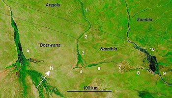
n border. Along this reach it flows in a maze of channels in a swampy corridor 5–10 km wide (map 1: the border with Zambia is the eastern bank of this floodplain, not the river channel). As with all rivers in south-central Africa its flow varies enormously between the rainy season when it floods and may be several kilometres wide, and the dry season when it may disappear into marshes.
The Cuando continues in its marshy channel across the neck of the Caprivi Strip
Caprivi Strip
Caprivi, sometimes called the Caprivi Strip , Caprivi Panhandle or the Okavango Strip and formally known as Itenge, is a narrow protrusion of Namibia eastwards about , between Botswana to the south, Angola and Zambia to the north, and Okavango Region to the west. Caprivi is bordered by the...
of Namibia
Namibia
Namibia, officially the Republic of Namibia , is a country in southern Africa whose western border is the Atlantic Ocean. It shares land borders with Angola and Zambia to the north, Botswana to the east and South Africa to the south and east. It gained independence from South Africa on 21 March...
(map, 2) and then forms the border between Namibia and Botswana as it continues southeast. Some 10,000 years ago, the Cuando merged with the Okavango River
Okavango River
The Okavango River is a river in southwest Africa. It is the fourth-longest river system in southern Africa, running southeastward for . It begins in Angola, where it is known as the Cubango River...
and they flowed south to Lake Makgadikgadi
Lake Makgadikgadi
Lake Makgadikgadi is an ancient lake that existed in what is now the Kalahari Desert in Botswana. It may have once covered as much as 80,000 km² and was 30 m deep...
(which is a seasonal wetland
Wetland
A wetland is an area of land whose soil is saturated with water either permanently or seasonally. Wetlands are categorised by their characteristic vegetation, which is adapted to these unique soil conditions....
in current times), but the land in that area was uplifted
Tectonic uplift
Tectonic uplift is a geological process most often caused by plate tectonics which increases elevation. The opposite of uplift is subsidence, which results in a decrease in elevation. Uplift may be orogenic or isostatic.-Orogenic uplift:...
. As a consequence the Cuando now meets slightly higher ground (map, 4) and breaks up into many channels and swamps (called the Linyanti Swamp) dotted with alluvial islands, nearly disappearing into the Kalahari sands like the Okavango (map, 5). But instead it has diverted east and has been captured
River capture
Stream capture, river capture, or stream piracy is a geomorphological phenomenon occurring when a stream or river drainage system or watershed is diverted from its own bed, and flows instead down the bed of a neighbouring stream...
by the Zambezi. The flow turns sharply east, still forming the border with Botswana
Botswana
Botswana, officially the Republic of Botswana , is a landlocked country located in Southern Africa. The citizens are referred to as "Batswana" . Formerly the British protectorate of Bechuanaland, Botswana adopted its new name after becoming independent within the Commonwealth on 30 September 1966...
. In the dry season there are few open channels through the swamps and marshes. Beginning at this point it is known as the Linyanti (map, 6), and after it flows through a seasonal lake, Lake Liambesi (map, 7), it is called the Chobe (map, 8). The river then flows into the Zambezi
Zambezi
The Zambezi is the fourth-longest river in Africa, and the largest flowing into the Indian Ocean from Africa. The area of its basin is , slightly less than half that of the Nile...
just above the Kazungula Ferry
Kazungula Ferry
The Kazungula Ferry is a pontoon ferry across the 400-metre-wide Zambezi River between Botswana and Zambia. It is one of the largest ferries in south-central Africa, having a capacity of 70 tonnes...
(map, 9).
In years when the Okavango experiences a good flood some of the water escapes east along the normally dry channel of the Magwekwana River into the Linyanti Swamp, thus entering the Zambezi basin. Otherwise the Okavango basin has no outlet.
On the north side of the Chobe River are the Caprivi Swamps, on the edge of which is the ruined capital of the Kololo people who conquered Barotseland
Barotseland
Barotseland is a region in the western part of Zambia, and is the homeland of the Lozi people or Barotse who were previously known as Luyi or Aluyi. Its heartland is the Barotse Floodplain on the upper Zambezi River, also known as Bulozi or Lyondo, but it includes the surrounding higher ground of...
in the 19th Century.
So much of the water of the Cuando, Linyanti and Chobe is lost to evaporation in the various swamps that its contribution to the flow of the Zambezi is very small except in occasional years when it floods excessively.
Wildlife
The Cuando system is noted for its wildlife and for most of its length the land either side is protected as game reserves or wildlife management areas. Some of these suffered poaching during wars and conflict in Namibia and Angola, but with peace restored in those countries they have the chance of returning to their former state.The national parks through which it passes or on which it borders are:
- Coutada Publica do Luiana (Angola)
- Sioma Ngwezi National ParkSioma Ngwezi National ParkSioma Ngwezi National Park is a 5000-square-kilometre park in the very south west corner of Zambia. It is undeveloped and rarely visited, lacking roads and being off the usual tourist tracks, but this may change in the future....
(Zambia) - West Caprivi Game Park (Namibia)
- Mudumu National ParkMudumu National ParkThe Mudumu National Park is a park in Namibia, created in 1990 out of 1009.59 square kilometers of savannah, mopane woodlands, and marsh on the eastern shore of the Cuando River. Many animals can be found in the park including sitatunga, red lechwe, as well as elephants, buffalo, kudu, impala,...
(Namibia) - Mamili National ParkMamili National ParkMamili National Park is a national park in Namibia.Mamili is centered on the Nkasa and Lupala islands on the Kwando and Linyanti rivers in the south-western corner of East Caprivi...
(Namibia) - Chobe National ParkChobe National ParkChobe National Park, in northwest Botswana, has one of the largest concentrations of game in Africa. By size, it is the third largest park of the country, after the Central Kalahari Game Reserve and the Gemsbok National Park, and is the most diverse...
(Botswana)