

Croydon Vision 2020
Encyclopedia
Croydon Vision 2020 is a regeneration programme by the London Borough of Croydon
for the centre of Croydon
in South London
. The original study was carried out in 1999 by EDAW and is being taken forward through the Local Development Framework process. The programme seeks to affect the urban planning
of Croydon extensively and promote Croydon as hub of living, retailing, culture and business in South London and South East England. It was also highlighted by architect Will Alsop's 'Third City' work. Private developers have responded to this initiative and currently £3.5 billion has been committed to consented and proposed development projects with more in the pipeline. The Council is now working with the Mayor of London on the Croydon Opportunity Area. An Opportunity Area Planning Framework (OAPF) has been proposed for the town centre to coordinate this investment. Work is underway on six masterplans underpinning the preparation of this framework. These are: East Croydon, West Croydon
, Mid Croydon, College Green
, Wellesley Road, and Old Town. More information can be found at the Council's 'Third City' website http://www.croydonthirdcity.co.uk. The website also includes information on the regeneration of Wandle Park
(one of central Croydon's three key greenspaces).
The East Croydon Masterplan planning permission is due on 21 July 2011.
 A 12.36 acres (50,019.2 m²) site adjacent to East Croydon railway station, the Stanhope Schroders Ruskin Square development is based around a park, new Warehouse Theatre
, together with homes and offices. The scheme has been designed by Foster and Partners
. Croydon Council previously supported proposals prepared by its development partner, Arrowcroft, to develop a mixed use scheme anchored by a 12,500 seat arena. However these proposals were rejected by the Secretary of State Hazel Blears in July 2008. Arrowcroft's proposals for the Croydon Gateway site also included:
The full decision rejecting the Planning Application and the Compulsory Purchase Order was issued on 31 July 2008 and 6 August 2008. The full documentation can be found at the public inquiry website
Following the withdrawal of Menta's original planning application, a new proposal was submitted to Croydon Council in March 2011. The main features of the new application are two residential buildings, including a 53-storey tower, providing a total of 499 homes including a proportion of low-cost housing, a 4-star ‘boutique’ hotel with 22 luxury serviced apartments, 71000 sq ft (6,596.1 m²) Grade A start-up office space, a new entry from Cherry Orchard Road into East Croydon train station via grand stairs and an open public space with restaurants and shops adjoining. The tall residential tower has caused controversy amongst the local residents in the neighbouring area with some objecting to the height which would make it the tallest building in the borough and one of the tallest residential buildings in the UK. A decision by Croydon Council on the planning permission is expected on 21 July 2011. Some of the buildings occupying the site including Amy Johnson House have already been completely demolished in 2011.
Architect - Atkins, Walters & Webster ( AWW )
 The proposed one million square foot redevelopment of Park Place was to create over 130 shops, cafès and restaurants, anchored by a new department store. Queen's Gardens
was to be completely remodelled, and a new bus interchange and tram stop was to be built. The improvements included other environmental, economic and social projects. The plan was intended to minimise the impact of the development activity in the town, and its aim was to address areas such as carbon emissions, recycling of waste material and the selection of building materials. This scheme collapsed in 2008. A new planning application for a development of shops and homes was expected to come to Croydon Council in early 2009.
concert and theatre venue, to create an arts and cultural quarter. A low-level piazza
will link the theatre with the nearby Queen's Gardens
. A remodelled open space will provide a new pedestrian boulevard to connect Queen's Gardens, Croydon College
and East Croydon Station
. Apartments will front the new boulevard and also enjoy views south across private gardens. The scheme will retain parking for both public and private use at lower levels. There will be a range of retail restaurants, cafès etc. around the piazza, linking with a new entrance and foyer to the Fairfield Halls. The current programme anticipates a planning application towards the end of 2006 and a start on site in 2007.
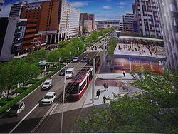 Wellesley Road is an urban dual carriageway dominated by the 1960s underpass and subways; cutting the heart of the town in two with a north-south physical barrier that is difficult to negotiate. The scale of the archiecture is dramatic, but pedestrians and public transport are pushed to the edges. The splitting of the town centre causes difficulties in the way central Croydon functions, with a lack of connections between major rail and bus stations, retail areas, office and cultural facilities and poor public access.
Croydon Council are examining the options for improving Croydon's environment, image and functioning including improvements for pedestrians and better access to public transport. Street-level crossings, trees, seating, lighting and kiosks, and a central pedestrian walkway are being considered. In the proposals it is likely that Wellesley Road will remain a main route for trams, buses and cars, possibly incorporating extensions to the Tramlink
network. The difference will be that these modes of transport will no longer dominate the space to the detriment of the pedestrian experience and the image of Croydon. There is also an opportunity to simplify and improve the movement of these vehicles. Opportunities exist for improving the ground floors and frontages of the buildings along Wellesley Road, connecting more effectively with their immediate surroundings creating more activity, such as shops and cafés with spill-out spaces. The Masterplanning team of Okra Landscape Architects with Peter Brett Associates, Soundings and Urhahn Urban Design was selected by the Council following an international design competition. http://www.croydonthirdcity.co.uk.
The masterplan also includes surrounding development sites:
This development has planning permission. Construction is due to start in 2008 with a completion date of 2012.
Plans to develop and expand the centre are currently being formalised and a planning application submitted. Construction of the extension is due to start in 2009 and be finished in 2014, as promised by Geddes Architects who are building the centre for Howard Holdings plc. Following Howard Holdings going into administration http://www.irishtimes.com/newspaper/finance/2009/1114/1224258815520.html the timescales for redevelopment are now being reconsidered.
The project is located on an island site at a main entrance to Croydon town centre that is seen by the Borough Council as a vital part of Croydon's housing regeneration. The scheme will include a central public garden. Every apartment will have access to a recessed balcony.
Rain water will be collected off the buildings and used to provide irrigation for the garden. Renewable sources of energy will be included, and there will be recycling facilities next to the lay-by. Over half of the site will be landscaped. The architect is Darling Associates who were hired by Phoenix Logistics and E3 Property as well as the engineers Walsh Group and Scott Wilson
. Construction started in 2007 with a completion predicted in summer 2012.
 In May 2010 the East London Line
extension to West Croydon was opened. This project connects Croydon to the new London Overground
rail system and improves Croydon's public transport connections to central and inner east London. It also provides the main impetus for building a modern public transport interchange at West Croydon station linking tram
, bus
and rail
. The East London Line extension will be a major contribution to London's transport infrastructure in time for the Olympic and Paralympic Games
to be held in the capital in 2012.
, TFL
and three train operators between 2003 and 2006 to encourage more passengers to travel by train. In partnership with the South London Boroughs
, including Croydon, SWELTRAC, SELTRANS and the transport users group, the scheme promoted the advantages of off-peak travel following improvements to safety, travel connections and upgrading of station facilities.
, now carries around 22 million passengers a year. An extension to Crystal Palace
is currently being developed by Transport for London
with the support of the council and South London Partnership. This would improve public transport access to Upper Norwood
and Crystal Palace Park and help to stimulate regeneration across the wider area. The extension could be in service by 2013. Other possible extensions include Reigate
, Redhill
, Gatwick Airport, Sutton
, M25 motorway
Park and Ride, Coulsdon
, Purley
, Kingston upon Thames
, Tolworth
, Tooting
, Brixton
(interchange with proposed Cross River Tram
), Bromley
and Lewisham
(interchange with Docklands Light Railway
).
as a whole, including leisure, offices, shopping, transport and homes. It also included a town centre model which can still be seen in Croydon Central Library
in the Croydon Clocktower
building.
London Borough of Croydon
The London Borough of Croydon is a London borough in South London, England and is part of Outer London. It covers an area of and is the largest London borough by population. It is the southernmost borough of London. At its centre is the historic town of Croydon from which the borough takes its name...
for the centre of Croydon
Croydon
Croydon is a town in South London, England, located within the London Borough of Croydon to which it gives its name. It is situated south of Charing Cross...
in South London
South London
South London is the southern part of London, England, United Kingdom.According to the 2011 official Boundary Commission for England definition, South London includes the London boroughs of Bexley, Bromley, Croydon, Greenwich, Kingston, Lambeth, Lewisham, Merton, Southwark, Sutton and...
. The original study was carried out in 1999 by EDAW and is being taken forward through the Local Development Framework process. The programme seeks to affect the urban planning
Urban planning
Urban planning incorporates areas such as economics, design, ecology, sociology, geography, law, political science, and statistics to guide and ensure the orderly development of settlements and communities....
of Croydon extensively and promote Croydon as hub of living, retailing, culture and business in South London and South East England. It was also highlighted by architect Will Alsop's 'Third City' work. Private developers have responded to this initiative and currently £3.5 billion has been committed to consented and proposed development projects with more in the pipeline. The Council is now working with the Mayor of London on the Croydon Opportunity Area. An Opportunity Area Planning Framework (OAPF) has been proposed for the town centre to coordinate this investment. Work is underway on six masterplans underpinning the preparation of this framework. These are: East Croydon, West Croydon
West Croydon
West Croydon may refer to:*West Croydon, South Australia*West Croydon railway station, Adelaide*West Croydon station, Croydon, England...
, Mid Croydon, College Green
College Green
College Green is a three-sided "square" in the centre of Dublin. On its northern side is a building known today as the Bank of Ireland which until 1800 was Ireland's Parliament House. To its east stands Trinity College Dublin, the only constituent college of the University of Dublin. To its south...
, Wellesley Road, and Old Town. More information can be found at the Council's 'Third City' website http://www.croydonthirdcity.co.uk. The website also includes information on the regeneration of Wandle Park
Wandle Park
Wandle Park is the name of two separate parks in London, on the course of the River Wandle.The Wandle Trail passes through both parks.-Wandle Park, Croydon:...
(one of central Croydon's three key greenspaces).
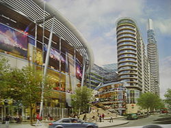
East Croydon Masterplan
- Ruskin Square - formerly the Croydon Gateway site. The site is in the ownership of Stanhope who are developing their scheme due to open in 2010. The Council together with its development partner Arrowcroft had previously proposed an arena-based scheme. The site, alongside East Croydon stationEast Croydon stationEast Croydon station is a railway station and tram stop in Croydon, 10.35 miles south of London Bridge in Travelcard Zone 5. It is the largest and busiest station in Croydon and the busiest in London outside Travelcard Zone 1 in terms of the number of passengers entering and exiting...
, would have included a 12,500 maximum capacity arena, offices, apartments, supermarket, health club, bars and restaurants. For this to occur the Council and Arrowcroft required planning consent together with a Compulsory Purchase Order to be granted. - Cherry Orchard Road - Developer Menta and architect Ken Shuttleworth's Make Practice are proposing a 93,000 m² mixed-use project designed as a series of crystalline towers. The development could also improve access to East Croydon station. Planning has been secured for this site to resident's and councillor's delight. The development requires office and residential values to increase substantially and this has been occurring due to what economist's call the "multiplier effect"; land has been assembled and the developer is going ahead with enabling developments for the Royal Mail and the meat packing company
- East Croydon StationEast Croydon stationEast Croydon station is a railway station and tram stop in Croydon, 10.35 miles south of London Bridge in Travelcard Zone 5. It is the largest and busiest station in Croydon and the busiest in London outside Travelcard Zone 1 in terms of the number of passengers entering and exiting...
- Central One
The East Croydon Masterplan planning permission is due on 21 July 2011.
Ruskin Square
Warehouse Theatre
The Warehouse Theatre is a professional producing theatre with one hundred seats in the centre of the London Borough of Croydon, south London, England based in an oak-beamed former cement Victorian warehouse...
, together with homes and offices. The scheme has been designed by Foster and Partners
Foster and Partners
Foster + Partners is an architectural firm based in London. The practice is led by its founder and Chairman, Norman Foster, and has constructed many high-profile glass-and-steel buildings....
. Croydon Council previously supported proposals prepared by its development partner, Arrowcroft, to develop a mixed use scheme anchored by a 12,500 seat arena. However these proposals were rejected by the Secretary of State Hazel Blears in July 2008. Arrowcroft's proposals for the Croydon Gateway site also included:
- Retail elements including a mix of shops, restaurants, cafés and bars including a new foodstore of 7,650 m²
- Over 500000 sq ft (46,451.5 m²) of 'Grade A' offices to bring new businesses to Croydon and meet the expansion needs of companies already based in the area
- Over 800 new homes - for both affordable rent and private sale - including a 35-storey residential tower
- A health and fitness centre and community health centre
- A pedestrian plaza
The full decision rejecting the Planning Application and the Compulsory Purchase Order was issued on 31 July 2008 and 6 August 2008. The full documentation can be found at the public inquiry website
Cherry Orchard Road
Menta's Second ProposalFollowing the withdrawal of Menta's original planning application, a new proposal was submitted to Croydon Council in March 2011. The main features of the new application are two residential buildings, including a 53-storey tower, providing a total of 499 homes including a proportion of low-cost housing, a 4-star ‘boutique’ hotel with 22 luxury serviced apartments, 71000 sq ft (6,596.1 m²) Grade A start-up office space, a new entry from Cherry Orchard Road into East Croydon train station via grand stairs and an open public space with restaurants and shops adjoining. The tall residential tower has caused controversy amongst the local residents in the neighbouring area with some objecting to the height which would make it the tallest building in the borough and one of the tallest residential buildings in the UK. A decision by Croydon Council on the planning permission is expected on 21 July 2011. Some of the buildings occupying the site including Amy Johnson House have already been completely demolished in 2011.
| Menta's Original Rejected Application (2009) |
|---|
| Menta, the private development company, together with Make Architects and planning adviser GL Hearn, is working up major regeneration proposals for Cherry Orchard Road in Croydon, which could also incorporate improvement and extension of East Croydon station. The planning application was withdrawn shortly before the Planning Committee meeting of 16 July 2009, where it was due to be considered. The Planning Officers recommended that the Councillors reject Menta's application. The mixed-use scheme was to total approximately 93,000 sq m (1 million sq ft) of new accommodation. Of the total area, some 70% will be residential accommodation, with the remaining 30% being of mixed commercial use, including offices and retail. Critical to all proposals around East Croydon Station are improvements to the transport interchange. No project has yet to deliver the necessary funds for significant enhancements. A number of glass-clad towers in a crescent shape were to adjoin other existing buildings in the area including the NLA Tower and the Addiscombe Addiscombe Addiscombe is a district of south London, England, located in the London Borough of Croydon. It is situated south of Charing Cross.It is situated just to the northeast of central Croydon, and is home to a high proportion of people who commute to Central London, owing to its proximity to the busy... community to the north east. The proposals included the relocation of the Royal Mail Royal Mail Royal Mail is the government-owned postal service in the United Kingdom. Royal Mail Holdings plc owns Royal Mail Group Limited, which in turn operates the brands Royal Mail and Parcelforce Worldwide... sorting office Sorting office Sorting office or Processing and Distribution Center is any location where postal operators bring mail after collection for sorting into batches for delivery to the addressee, which may be a direct delivery or sent onwards to another regional or local sorting office, or to another postal... to new premises on a nearby site on Cherry Orchard Road, maintaining the mixture of commercial and residential property that typifies the surrounding area. Originally to be finished by 2018, a series of complications pointed out by Menta, the client, about the architecture of the buildings designed by Make and engineered by Knight Frank and GL Hearn have led to it being postponed until 2019 with construction ending in 2023. |
Central One
Central One will be a new high-rise business park. Office floor spaces of approximately 25000 sq ft (2,322.6 m²), totalling 500000 sq ft (46,451.5 m²), will be provided over 40 storeys. The building will have internal atria every 6th floor and extensive public areas, with amenities such as cafès, restaurants, shops, and a fitness centre.Old Town Masterplan
- The Exchange and Bridge House - Howard Holdings a former Croydon-based international developer had three residential developments compromising of 36,896 m² providing 337 apartments in the town centre. These projects are: The Exchange, Bridge House and Altitude 25Altitude 25Altitude 25 is Croydon's tallest skyscraper on Fairfield Road in the London Borough of Croydon, London. The development was intended to regenerate a brownfield site just three minutes' walk from East Croydon station...
, the three developments include car parking, shopping and leisure facilities. Howard Holdings also had a development agreement Whitgift CentreWhitgift CentreThe Whitgift Centre is a large shopping centre and office development in the centre of Croydon, London, opened in stages between 1968 and 1970. The centre currently comprises of retail space and was the largest covered shopping development in Greater London until the opening of Westfield London at...
, which was due to be redeveloped. Clowater, a new business led by former Howard managing director Jason Clerkin and development director Paul Hannon http://www.irishtimes.com/newspaper/finance/2009/1114/1224258815520.html, are completing Bridge House and Exchange Square. - Surrey Street
- The Pumping Station
Projects
Architect - Atkins, Walters & Webster ( AWW )
Mid Croydon Masterplan
- Park Place - Minerva and Lend LeaseLend Lease CorporationLend Lease Group is a global property and infrastructure company headquartered in Sydney, Australia...
's proposed scheme covering more than 1000000 sq ft (92,903 m²) includes a shopping mall, bus station and office development with a new public square, similar in size to Covent Garden's piazza, in the centre of Croydon. It has full planning permission and has completed a CPO process to assemble the land. The development start date is unknown as no anchor department store has been confirmed. - Civic Complex
Park Place
Queen's Gardens (Croydon)
The Queen's Gardens are a small area of urban gardens in the centre of Croydon, South London. It is part of the Croydon Vision 2020 re-generation plan with Park Place. They are bordered by Croydon Town Hall, Taberner house, Park Lane and Katharine Street....
was to be completely remodelled, and a new bus interchange and tram stop was to be built. The improvements included other environmental, economic and social projects. The plan was intended to minimise the impact of the development activity in the town, and its aim was to address areas such as carbon emissions, recycling of waste material and the selection of building materials. This scheme collapsed in 2008. A new planning application for a development of shops and homes was expected to come to Croydon Council in early 2009.
College Green Masterplan
- 100 George Street - A new 25,824 m² office and retail development directly opposite East Croydon station.
- Fairfield Hall
- Croydon College
- College Green
- Altitude 25
Fairfield Hall
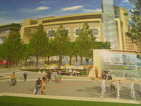
The scheme is centred upon the refurbishment and part redevelopment of the Fairfield HallsFairfield Halls
Fairfield Hall is an arts centre in Croydon, London, England and opened in 1962. It contains a concert hall, the Ashcroft Theatre , the Arnhem Gallery civic hall and an art gallery....
concert and theatre venue, to create an arts and cultural quarter. A low-level piazza
Piazza
A piazza is a city square in Italy, Malta, along the Dalmatian coast and in surrounding regions. The term is roughly equivalent to the Spanish plaza...
will link the theatre with the nearby Queen's Gardens
Queen's Gardens (Croydon)
The Queen's Gardens are a small area of urban gardens in the centre of Croydon, South London. It is part of the Croydon Vision 2020 re-generation plan with Park Place. They are bordered by Croydon Town Hall, Taberner house, Park Lane and Katharine Street....
. A remodelled open space will provide a new pedestrian boulevard to connect Queen's Gardens, Croydon College
Croydon College
Croydon College, established in 1895, is a Further Education and Higher Education institution in the London Borough of Croydon.Located in East Croydon, it is made up of a Further Education College and a Higher Education College.- Further Education :...
and East Croydon Station
East Croydon station
East Croydon station is a railway station and tram stop in Croydon, 10.35 miles south of London Bridge in Travelcard Zone 5. It is the largest and busiest station in Croydon and the busiest in London outside Travelcard Zone 1 in terms of the number of passengers entering and exiting...
. Apartments will front the new boulevard and also enjoy views south across private gardens. The scheme will retain parking for both public and private use at lower levels. There will be a range of retail restaurants, cafès etc. around the piazza, linking with a new entrance and foyer to the Fairfield Halls. The current programme anticipates a planning application towards the end of 2006 and a start on site in 2007.
Wellesley Road Masterplan
Croydon Council are examining the options for improving Croydon's environment, image and functioning including improvements for pedestrians and better access to public transport. Street-level crossings, trees, seating, lighting and kiosks, and a central pedestrian walkway are being considered. In the proposals it is likely that Wellesley Road will remain a main route for trams, buses and cars, possibly incorporating extensions to the Tramlink
Tramlink
Tramlink is a tramway system in south London in the United Kingdom which began operation in May 2000...
network. The difference will be that these modes of transport will no longer dominate the space to the detriment of the pedestrian experience and the image of Croydon. There is also an opportunity to simplify and improve the movement of these vehicles. Opportunities exist for improving the ground floors and frontages of the buildings along Wellesley Road, connecting more effectively with their immediate surroundings creating more activity, such as shops and cafés with spill-out spaces. The Masterplanning team of Okra Landscape Architects with Peter Brett Associates, Soundings and Urhahn Urban Design was selected by the Council following an international design competition. http://www.croydonthirdcity.co.uk.
The masterplan also includes surrounding development sites:
- Saffron Square (formerly known as Wellesley Square) - Berkeley Homes proposes a mixed-use development consisting of a 45 storey tower, 800 new homes, 3000 m² of retail and public realm including a new town square. Planning permission was given in 2008 for the tower, although construction has yet to commence in 2010.
- IYLO - Joint developers Phoenix Logistics and E3 Property's new residential 20 storey tower with ancillary public gardens is planned to become a focal point at the city's northern gateway. This development has full planning. Site clearance has been undertaken.
- Whitgift CentreWhitgift CentreThe Whitgift Centre is a large shopping centre and office development in the centre of Croydon, London, opened in stages between 1968 and 1970. The centre currently comprises of retail space and was the largest covered shopping development in Greater London until the opening of Westfield London at...
Saffron Square
This strategic site on Wellesley Road has lain fallow for over 10 years and Berkeley Homes plans to use it to deliver a mixed-use development. Proposals for this northern gateway site include:- A new public town square
- A prominent 44-storey tower
- 3,000 m² of retail floorspace including shops, restaurants and cafés surrounding the public square
- 739 new homes, 10% of which will be for shared ownership housing
- Ideas to minimise the scheme's impact on the environment. A significant proportion of the site's energy requirements will be met by on-site renewable energy sources.
- Creation of improved permeabilityPermeability (spatial and transport planning)Permeability or connectivity describes the extent to which urban forms permit movement of people or vehicles in different directions. The terms are often used interchangeably, although differentiated definitions also exist...
and safeguarding of future pedestrian links between East and West Croydon stationWest Croydon stationWest Croydon station is a transport interchange for National Rail and Tramlink services, as well as London Buses. It is in the London Borough of Croydon and Travelcard Zone 5...
s.
This development has planning permission. Construction is due to start in 2008 with a completion date of 2012.
Whitgift Centre
Howard Holdings had a development agreement with the Whitgift Centre in the middle of town for £221m. The 93,000 m² shopping and office centre currently draws in 24.2 million shoppers annually. It is rated as the UK's 9th busiest shopping centre and is one of the biggest shopping centres in Europe.Plans to develop and expand the centre are currently being formalised and a planning application submitted. Construction of the extension is due to start in 2009 and be finished in 2014, as promised by Geddes Architects who are building the centre for Howard Holdings plc. Following Howard Holdings going into administration http://www.irishtimes.com/newspaper/finance/2009/1114/1224258815520.html the timescales for redevelopment are now being reconsidered.
IYLO
IYLO's architects, Darling Associates, propose a glass-clad elliptical tower of two equal halves that appear to be sliding past each other. The 20-storey building will provide 183 private apartments.The project is located on an island site at a main entrance to Croydon town centre that is seen by the Borough Council as a vital part of Croydon's housing regeneration. The scheme will include a central public garden. Every apartment will have access to a recessed balcony.
Rain water will be collected off the buildings and used to provide irrigation for the garden. Renewable sources of energy will be included, and there will be recycling facilities next to the lay-by. Over half of the site will be landscaped. The architect is Darling Associates who were hired by Phoenix Logistics and E3 Property as well as the engineers Walsh Group and Scott Wilson
Scott Wilson Group
Scott Wilson Group plc, with over 5,500 members of staff, is a global integrated design and engineering consultancy for the built and natural environments...
. Construction started in 2007 with a completion predicted in summer 2012.
West Croydon Masterplan
The area to be changed adjoins the North End shopping precinct and contains West Croydon train station, West Croydon bus terminal, West Croydon tram stop as well as historic landmarks such as the St Michael and All Angels Church.East London Line Extension
East London Line
The East London Line is a London Overground line which runs north to south through the East End, Docklands and South areas of London.Built in 1869 by the East London Railway Company, which reused the Thames Tunnel, originally intended for horse-drawn carriages, the line became part of the London...
extension to West Croydon was opened. This project connects Croydon to the new London Overground
London Overground
London Overground is a suburban rail network in London and Hertfordshire. It has been operated by London Overground Rail Operations since 2007 as part of the National Rail network, under the franchise control and branding of Transport for London...
rail system and improves Croydon's public transport connections to central and inner east London. It also provides the main impetus for building a modern public transport interchange at West Croydon station linking tram
Tram
A tram is a passenger rail vehicle which runs on tracks along public urban streets and also sometimes on separate rights of way. It may also run between cities and/or towns , and/or partially grade separated even in the cities...
, bus
Bus
A bus is a road vehicle designed to carry passengers. Buses can have a capacity as high as 300 passengers. The most common type of bus is the single-decker bus, with larger loads carried by double-decker buses and articulated buses, and smaller loads carried by midibuses and minibuses; coaches are...
and rail
Rail transport
Rail transport is a means of conveyance of passengers and goods by way of wheeled vehicles running on rail tracks. In contrast to road transport, where vehicles merely run on a prepared surface, rail vehicles are also directionally guided by the tracks they run on...
. The East London Line extension will be a major contribution to London's transport infrastructure in time for the Olympic and Paralympic Games
2012 Summer Olympics
The 2012 Summer Olympic Games, officially known as the "London 2012 Olympic Games", are scheduled to take place in London, England, United Kingdom from 27 July to 12 August 2012...
to be held in the capital in 2012.
Improved Overground Network (ON)
This was a pilot scheme run by the SRAStrategic Rail Authority
In existence from 2001 to 2006, the Strategic Rail Authority was a non-departmental public body in the United Kingdom set up under the Transport Act 2000 to provide strategic direction for the railway industry....
, TFL
Transport for London
Transport for London is the local government body responsible for most aspects of the transport system in Greater London in England. Its role is to implement the transport strategy and to manage transport services across London...
and three train operators between 2003 and 2006 to encourage more passengers to travel by train. In partnership with the South London Boroughs
South London
South London is the southern part of London, England, United Kingdom.According to the 2011 official Boundary Commission for England definition, South London includes the London boroughs of Bexley, Bromley, Croydon, Greenwich, Kingston, Lambeth, Lewisham, Merton, Southwark, Sutton and...
, including Croydon, SWELTRAC, SELTRANS and the transport users group, the scheme promoted the advantages of off-peak travel following improvements to safety, travel connections and upgrading of station facilities.
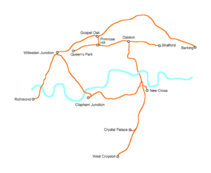
Tramlink Extension
Croydon's light rail system, TramlinkTramlink
Tramlink is a tramway system in south London in the United Kingdom which began operation in May 2000...
, now carries around 22 million passengers a year. An extension to Crystal Palace
Crystal Palace, London
Crystal Palace is a residential area in south London, England named from the former local landmark, The Crystal Palace, which occupied the area from 1854 to 1936. The area is located approximately 8 miles south east of Charing Cross, and offers impressive views over the capital...
is currently being developed by Transport for London
Transport for London
Transport for London is the local government body responsible for most aspects of the transport system in Greater London in England. Its role is to implement the transport strategy and to manage transport services across London...
with the support of the council and South London Partnership. This would improve public transport access to Upper Norwood
Upper Norwood
Upper Norwood is an elevated area in south London, England within the postcode SE19. It is a residential district largely in the London Borough of Croydon although some parts extend into the London Borough of Lambeth, London Borough of Southwark and the London Borough of Bromley. Upper Norwood...
and Crystal Palace Park and help to stimulate regeneration across the wider area. The extension could be in service by 2013. Other possible extensions include Reigate
Reigate
Reigate is a historic market town in Surrey, England, at the foot of the North Downs, and in the London commuter belt. It is one of the main constituents of the Borough of Reigate and Banstead...
, Redhill
Redhill railway station
Redhill railway station serves the town of Redhill, Surrey, England. The station is a major interchange point on the Brighton Main Line 21 miles south of London Victoria...
, Gatwick Airport, Sutton
Sutton, London
Sutton is a large suburban town in southwest London, England, and the administrative headquarters of the London Borough of Sutton. It is located south-southwest of Charing Cross and is one of the major metropolitan centres identified in the London Plan. The town was connected to central London by...
, M25 motorway
M25 motorway
The M25 motorway, or London Orbital, is a orbital motorway that almost encircles Greater London, England, in the United Kingdom. The motorway was first mooted early in the 20th century. A few sections, based on the now abandoned London Ringways plan, were constructed in the early 1970s and it ...
Park and Ride, Coulsdon
Coulsdon
Coulsdon is a town on the southernmost boundary of the London Borough of Croydon. It is surrounded by the Metropolitan Green Belt of the Farthing Down, Coulsdon Common and Kenley Common...
, Purley
Purley, London
Purley is a place in the London Borough of Croydon, England. It is a suburban development situated 11.7 miles south of Charing Cross.The name derives from "pirlea", which means 'Peartree lea'. Purley has a population of about 72,000....
, Kingston upon Thames
Kingston upon Thames
Kingston upon Thames is the principal settlement of the Royal Borough of Kingston upon Thames in southwest London. It was the ancient market town where Saxon kings were crowned and is now a suburb situated south west of Charing Cross. It is one of the major metropolitan centres identified in the...
, Tolworth
Tolworth
Tolworth is a mostly residential area of outer South London in the Royal Borough of Kingston upon Thames, located south west of Charing Cross. Neighbouring places include: New Malden, Kingston, Surbiton, Berrylands, Chessington, Ewell and Worcester Park....
, Tooting
Tooting
Tooting is a district in south London, England, located in the London Borough of Wandsworth. It is situated south south-west of Charing Cross. The area is identified in the London Plan as one of 35 major centres in Greater London.-History:...
, Brixton
Brixton
Brixton is a district in the London Borough of Lambeth in south London, England. It is south south-east of Charing Cross. The area is identified in the London Plan as one of 35 major centres in Greater London....
(interchange with proposed Cross River Tram
Cross River Tram
Cross River Tram was a Transport for London proposal for a tram system in London, England, UK. It was planned to run on a north-south route from Camden Town in the north, through and , to Peckham and Brixton in the south....
), Bromley
Bromley
Bromley is a large suburban town in south east London, England and the administrative headquarters of the London Borough of Bromley. It was historically a market town, and prior to 1963 was in the county of Kent and formed the administrative centre of the Municipal Borough of Bromley...
and Lewisham
Lewisham
Lewisham is a district in South London, England, located in the London Borough of Lewisham. It is situated south-east of Charing Cross. The area is identified in the London Plan as one of 35 major centres in Greater London.-History:...
(interchange with Docklands Light Railway
Docklands Light Railway
The Docklands Light Railway is an automated light metro or light rail system opened on 31 August 1987 to serve the redeveloped Docklands area of London...
).
Croydon Expo
The Croydon Exp07 was a series of exhibitions highlighting the re-development of the London Borough of CroydonLondon Borough of Croydon
The London Borough of Croydon is a London borough in South London, England and is part of Outer London. It covers an area of and is the largest London borough by population. It is the southernmost borough of London. At its centre is the historic town of Croydon from which the borough takes its name...
as a whole, including leisure, offices, shopping, transport and homes. It also included a town centre model which can still be seen in Croydon Central Library
Croydon Central Library
Croydon Central Library is Croydon's main public library located inside the Croydon Clocktower in Croydon, south London. It is owned by the London Borough of Croydon on behalf of Croydon Council. The library is located on four floors inside the Clocktower...
in the Croydon Clocktower
Croydon Clocktower
Croydon Clocktower on Katharine Street in Croydon is an arts centre in London, England. It contains the Museum of Croydon, the Riesco Gallery with a collection of Chinese pottery and ceramics, the David Lean Cinema, the Braithwaite Hall used for concerts and conferences, and a café and bar...
building.