
Crow Wing County, Minnesota
Encyclopedia
Crow Wing County is a county located in the U.S. state
of Minnesota
. As of 2010, the population was 62,500. Its county seat
is Brainerd
.
which gets its name from an island in the river that is shaped like the wing of a crow.
Twenty years or more before the county was outlined and named, a trading post was established on the east side of the Mississippi River
opposite the mouth of the Crow Wing River. In 1837 there was again a station of the fur traders facing the northern mouth of the Crow Wing River. A few years later it became the center of Indian trading and had the general supply store for the area. By 1866 the village contained about 600 whites and Chippewas.
The part of Crow Wing County west of the Mississippi was annexed from Cass County by an act of the Legislature on February 18, 1887, doubling its former area.
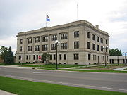
Brainerd
township was founded in 1870 when the Northern Pacific survey determined that the crossing of the Mississippi should be there. It became a city on November 19, 1881. The name was chosen in honor of the wife of J. Gregory Smith
, the first president of the Northern Pacific Railroad Company. Mrs. Brainerd Smith was the author of novels, books of travel and other works.
The Northern Pacific Railroad ran its first train to Brainerd, a special train, on march 11, 1871 and its regular passenger service began the next September. The first passenger train from the Twin Cities
, by way of Sauk Rapids, came November 1, 1877. Crow Wing, the former trading post, was soon superseded by Brainerd.
s, the Crow Wing State Forest
and the Emily State Forest
. It also has the Cuyuna Lakes State Trail which lies in the Upper Mississippi River
Basin. The topography of the region is gently rolling to flat, with waters and wetlands generously interspersed with the woodlands that cover the landscape. It is home to an abundance of wildlife
. Visitors may have the opportunity to see white-tailed deer
, cottontail rabbit
, snowshoe hare
, raccoon
, red fox
, gray fox
, coyote
, mink
, muskrat
, squirrel
s, and beaver
. Occasionally, American Black Bear
s may be observed. Bald Eagle
s and Osprey
frequent the area, and many species of waterfowl
also take advantage of the abundant aquatic habitat found in the marshes and lakes of the county.
There are many lakes and rivers in Crow Wing County. The main river is the Crow Wing River
although there are more smaller streams in the county too. It has about 417 recognized lakes. The top ten ranked according to size are:
1.Gull Lake – 9419 acres (38.1 km²)
2.Pelican Lake
– 8254 acres (33.4 km²)
3. Upper and Lower White Fish Lake – 7372 acres (29.8 km²)
4.North Long Lake
– 5997 acres (24.3 km²)
5.Bay Lake
– 2393 acres (9.7 km²)
6.Edward Lake – 2033 acres (8.2 km²)
7.Cross Lake
– 1752 acres (7.1 km²)
8.Round Lake
– 1645 acres (6.7 km²)
9.Big Trout Lake – 1343 acres (5.4 km²)
10.Lower South Long Lake – 1312 acres (5.3 km²)
of 2000, there were 55,099 people, 22,250 households, and 15,174 families residing in the county. The population density
was 55 people per square mile (21/km²). There were 33,483 housing units at an average density of 34 per square mile (13/km²). The racial makeup of the county was 97.64% White
, 0.31% Black
or African American
, 0.78% Native American
, 0.28% Asian
, 0.01% Pacific Islander
, 0.20% from other races
, and 0.78% from two or more races. 0.69% of the population were Hispanic
or Latino
of any race. 32.5% were of German, 16.4% Norwegian, 9.4% Swedish, 6.2% Irish
and 5.2% American
ancestry according to Census 2000.
There were 22,250 households out of which 30.20% had children under the age of 18 living with them, 56.70% were married couples
living together, 8.00% had a female householder with no husband present, and 31.80% were non-families. 26.40% of all households were made up of individuals and 11.70% had someone living alone who was 65 years of age or older. The average household size was 2.43 and the average family size was 2.93.
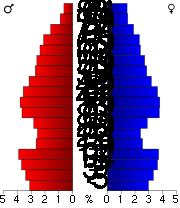 In the county the population was spread out with 24.80% under the age of 18, 8.10% from 18 to 24, 25.60% from 25 to 44, 24.40% from 45 to 64, and 17.10% who were 65 years of age or older. The median age was 39 years. For every 100 females there were 96.80 males. For every 100 females age 18 and over, there were 94.50 males.
The median income for a household in the county was $37,589, and the median income for a family was $44,847. Males had a median income of $33,838 versus $22,896 for females. The per capita income
for the county was $19,174. About 6.50% of families and 9.80% of the population were below the poverty line, including 11.40% of those under age 18 and 9.90% of those age 65 or over.
U.S. state
A U.S. state is any one of the 50 federated states of the United States of America that share sovereignty with the federal government. Because of this shared sovereignty, an American is a citizen both of the federal entity and of his or her state of domicile. Four states use the official title of...
of Minnesota
Minnesota
Minnesota is a U.S. state located in the Midwestern United States. The twelfth largest state of the U.S., it is the twenty-first most populous, with 5.3 million residents. Minnesota was carved out of the eastern half of the Minnesota Territory and admitted to the Union as the thirty-second state...
. As of 2010, the population was 62,500. Its county seat
County seat
A county seat is an administrative center, or seat of government, for a county or civil parish. The term is primarily used in the United States....
is Brainerd
Brainerd, Minnesota
Brainerd is a city in Crow Wing County, Minnesota, United States. The population was 13,590 at the 2010 census. It is the county seat of Crow Wing County and one of the largest cities in Central Minnesota...
.
Geography
According to the 2000 census, the county has a total area of 1156.56 square miles (2,995.5 km²), of which 996.57 square miles (2,581.1 km²) (or 86.17%) is land and 160 square miles (414.4 km²) (or 13.83%) is water.History
Crow Wing county was established on May 23, 1857 and organized March 3, 1879. It is named for the Crow Wing RiverCrow Wing River
The Crow Wing River is a tributary of the Mississippi River approximately in length. The river arises in a chain of 11 lakes in southern Hubbard County, Minnesota and flows generally southeast, entering the Mississippi at Crow Wing State Park, northwest of Little Falls, Minnesota. Its name is a...
which gets its name from an island in the river that is shaped like the wing of a crow.
Twenty years or more before the county was outlined and named, a trading post was established on the east side of the Mississippi River
Mississippi River
The Mississippi River is the largest river system in North America. Flowing entirely in the United States, this river rises in western Minnesota and meanders slowly southwards for to the Mississippi River Delta at the Gulf of Mexico. With its many tributaries, the Mississippi's watershed drains...
opposite the mouth of the Crow Wing River. In 1837 there was again a station of the fur traders facing the northern mouth of the Crow Wing River. A few years later it became the center of Indian trading and had the general supply store for the area. By 1866 the village contained about 600 whites and Chippewas.
The part of Crow Wing County west of the Mississippi was annexed from Cass County by an act of the Legislature on February 18, 1887, doubling its former area.
Brainerd
Brainerd, Minnesota
Brainerd is a city in Crow Wing County, Minnesota, United States. The population was 13,590 at the 2010 census. It is the county seat of Crow Wing County and one of the largest cities in Central Minnesota...
township was founded in 1870 when the Northern Pacific survey determined that the crossing of the Mississippi should be there. It became a city on November 19, 1881. The name was chosen in honor of the wife of J. Gregory Smith
J. Gregory Smith
John Gregory Smith , railroad tycoon, politician, war-time governor of VermontSmith was born in St. Albans, Vermont, son of John and Maria Smith. The elder Smith was a pioneer railroad builder in Vermont, and a leading lawyer and public man of his generation...
, the first president of the Northern Pacific Railroad Company. Mrs. Brainerd Smith was the author of novels, books of travel and other works.
The Northern Pacific Railroad ran its first train to Brainerd, a special train, on march 11, 1871 and its regular passenger service began the next September. The first passenger train from the Twin Cities
Twin cities
Twin cities are a special case of two cities or urban centres which are founded in close geographic proximity and then grow into each other over time...
, by way of Sauk Rapids, came November 1, 1877. Crow Wing, the former trading post, was soon superseded by Brainerd.
| Year | Democrat Democratic Party (United States) The Democratic Party is one of two major contemporary political parties in the United States, along with the Republican Party. The party's socially liberal and progressive platform is largely considered center-left in the U.S. political spectrum. The party has the lengthiest record of continuous... |
Republican Republican Party (United States) The Republican Party is one of the two major contemporary political parties in the United States, along with the Democratic Party. Founded by anti-slavery expansion activists in 1854, it is often called the GOP . The party's platform generally reflects American conservatism in the U.S... |
|---|---|---|
| 2008 | 45.10% 15,859 | 52.80% 18,567 |
| 2004 | 41.75% 14,005 | 56.96% 19,106 |
| 2000 | 40.01% 11,255 | 53.45% 15,035 |
Topography
Crow Wing County has two state forestState forest
A state forest is a forest that is administered or protected by some agency of a sovereign state.The precise application of the term varies by jurisdiction...
s, the Crow Wing State Forest
Crow Wing State Forest
The Crow Wing State Forest is a state forest located near Fairfield Township in Crow Wing County, Minnesota. It is about northeast of the tourism-based town of Brainerd. Approximately of the forest of is actively managed...
and the Emily State Forest
Emily State Forest
The Emily State Forest is a state forest located near the town of Emily in the Crow Wing County, Minnesota. With an area of , it is the smallest state forest in Minnesota. In addition to hiking and hunting, backcountry camping is allowed within the forest, defined campsites are located at the...
. It also has the Cuyuna Lakes State Trail which lies in the Upper Mississippi River
Upper Mississippi River
The Upper Mississippi River is the portion of the Mississippi River upstream of Cairo, Illinois, United States. From the headwaters at Lake Itasca, Minnesota, the river flows approximately 2000 kilometers to Cairo, where it is joined by the Ohio River to form the Lower Mississippi...
Basin. The topography of the region is gently rolling to flat, with waters and wetlands generously interspersed with the woodlands that cover the landscape. It is home to an abundance of wildlife
Wildlife
Wildlife includes all non-domesticated plants, animals and other organisms. Domesticating wild plant and animal species for human benefit has occurred many times all over the planet, and has a major impact on the environment, both positive and negative....
. Visitors may have the opportunity to see white-tailed deer
White-tailed Deer
The white-tailed deer , also known as the Virginia deer or simply as the whitetail, is a medium-sized deer native to the United States , Canada, Mexico, Central America, and South America as far south as Peru...
, cottontail rabbit
Cottontail rabbit
The cottontail rabbits are among the 16 lagomorph species in the genus Sylvilagus, found in the Americas.In appearance, most cottontail rabbits closely resemble the wild European Rabbit...
, snowshoe hare
Snowshoe Hare
The Snowshoe Hare , also called the Varying Hare, or Snowshoe Rabbit, is a species of hare found in North America. It has the name "snowshoe" because of the large size of its hind feet and the marks its tail leaves. The animal's feet prevent it from sinking into the snow when it hops and walks...
, raccoon
Raccoon
Procyon is a genus of nocturnal mammals, comprising three species commonly known as raccoons, in the family Procyonidae. The most familiar species, the common raccoon , is often known simply as "the" raccoon, as the two other raccoon species in the genus are native only to the tropics and are...
, red fox
Red Fox
The red fox is the largest of the true foxes, as well as being the most geographically spread member of the Carnivora, being distributed across the entire northern hemisphere from the Arctic Circle to North Africa, Central America, and the steppes of Asia...
, gray fox
Gray Fox
The gray fox is a mammal of the order Carnivora ranging throughout most of the southern half of North America from southern Canada to the northern part of South America...
, coyote
Coyote
The coyote , also known as the American jackal or the prairie wolf, is a species of canine found throughout North and Central America, ranging from Panama in the south, north through Mexico, the United States and Canada...
, mink
Mink
There are two living species referred to as "mink": the European Mink and the American Mink. The extinct Sea Mink is related to the American Mink, but was much larger. All three species are dark-colored, semi-aquatic, carnivorous mammals of the family Mustelidae, which also includes the weasels and...
, muskrat
Muskrat
The muskrat , the only species in genus Ondatra, is a medium-sized semi-aquatic rodent native to North America, and introduced in parts of Europe, Asia, and South America. The muskrat is found in wetlands and is a very successful animal over a wide range of climates and habitats...
, squirrel
Squirrel
Squirrels belong to a large family of small or medium-sized rodents called the Sciuridae. The family includes tree squirrels, ground squirrels, chipmunks, marmots , flying squirrels, and prairie dogs. Squirrels are indigenous to the Americas, Eurasia, and Africa and have been introduced to Australia...
s, and beaver
Beaver
The beaver is a primarily nocturnal, large, semi-aquatic rodent. Castor includes two extant species, North American Beaver and Eurasian Beaver . Beavers are known for building dams, canals, and lodges . They are the second-largest rodent in the world...
. Occasionally, American Black Bear
American black bear
The American black bear is a medium-sized bear native to North America. It is the continent's smallest and most common bear species. Black bears are omnivores, with their diets varying greatly depending on season and location. They typically live in largely forested areas, but do leave forests in...
s may be observed. Bald Eagle
Bald Eagle
The Bald Eagle is a bird of prey found in North America. It is the national bird and symbol of the United States of America. This sea eagle has two known sub-species and forms a species pair with the White-tailed Eagle...
s and Osprey
Osprey
The Osprey , sometimes known as the sea hawk or fish eagle, is a diurnal, fish-eating bird of prey. It is a large raptor, reaching more than in length and across the wings...
frequent the area, and many species of waterfowl
Waterfowl
Waterfowl are certain wildfowl of the order Anseriformes, especially members of the family Anatidae, which includes ducks, geese, and swans....
also take advantage of the abundant aquatic habitat found in the marshes and lakes of the county.
There are many lakes and rivers in Crow Wing County. The main river is the Crow Wing River
Crow Wing River
The Crow Wing River is a tributary of the Mississippi River approximately in length. The river arises in a chain of 11 lakes in southern Hubbard County, Minnesota and flows generally southeast, entering the Mississippi at Crow Wing State Park, northwest of Little Falls, Minnesota. Its name is a...
although there are more smaller streams in the county too. It has about 417 recognized lakes. The top ten ranked according to size are:
1.Gull Lake – 9419 acres (38.1 km²)
2.Pelican Lake
Pelican Lake (Minnesota)
Pelican Lake is a lake located about seven miles north of Pelican Rapids, in Otter Tail County, Minnesota, United States. Pelican Lake is now a highly developed lake with its major uses being predominantly recreation, but its fishing is also excellent...
– 8254 acres (33.4 km²)
3. Upper and Lower White Fish Lake – 7372 acres (29.8 km²)
4.North Long Lake
North Long Lake
At 6,000 acres , North Long Lake is one of the larger lakes in the Brainerd Lakes Area of the U.S. state of Minnesota.-External links:**...
– 5997 acres (24.3 km²)
5.Bay Lake
Bay Lake (Minnesota)
Bay Lake is a body of water located in the Brainerd Lakes region of Minnesota. The lake has a surface area of and approximately of shoreline. The maximum depth of the lake is with a water clarity of...
– 2393 acres (9.7 km²)
6.Edward Lake – 2033 acres (8.2 km²)
7.Cross Lake
Cross Lake
Cross Lake lies on the border of Cayuga and Onondaga Counties in New York. Cross Lake lies within the boundaries of the traditional Onondaga Indian Nation. The lake is reputed in local tradition to be the boyhood home of Hiawatha, the great peace maker...
– 1752 acres (7.1 km²)
8.Round Lake
Round Lake
-Communities:United States* Round Lake, Illinois, a village* Round Lake, Minnesota, a city* Round Lake, New York, a village* Round Lake, Wisconsin, a town-Lakes:Canada* Round Lake , near Pembroke* Round Lake United States...
– 1645 acres (6.7 km²)
9.Big Trout Lake – 1343 acres (5.4 km²)
10.Lower South Long Lake – 1312 acres (5.3 km²)
Major highways
|


 Minnesota State Highway 309
Adjacent counties
- Aitkin CountyAitkin County, MinnesotaAitkin County is a county located in the U.S. state of Minnesota. As of 2010, the population is 16,202. Its county seat is Aitkin. A portion of the Mille Lacs Indian Reservation is in the county.-History:...
(northeast) - Mille Lacs CountyMille Lacs County, MinnesotaAs of the census of 2000, there were 22,330 people, 8,638 households, and 6,003 families residing in the county. The population density was 39 people per square mile . There were 10,467 housing units at an average density of 18 per square mile...
(southeast) - Morrison CountyMorrison County, Minnesota-Demographics:As of the census of 2000, there were 31,712 people, 11,816 households, and 8,460 families residing in the county. The population density was 28 people per square mile . There were 13,870 housing units at an average density of 12 per square mile...
(southwest) - Cass CountyCass County, MinnesotaCass County is a county located in the U.S. state of Minnesota. As of 2010, the population was 28,567. Its county seat is Walker. A portion of the Leech Lake Indian Reservation is in the county.-Geography:...
(northwest, north)
Demographics
As of the censusCensus
A census is the procedure of systematically acquiring and recording information about the members of a given population. It is a regularly occurring and official count of a particular population. The term is used mostly in connection with national population and housing censuses; other common...
of 2000, there were 55,099 people, 22,250 households, and 15,174 families residing in the county. The population density
Population density
Population density is a measurement of population per unit area or unit volume. It is frequently applied to living organisms, and particularly to humans...
was 55 people per square mile (21/km²). There were 33,483 housing units at an average density of 34 per square mile (13/km²). The racial makeup of the county was 97.64% White
Race (United States Census)
Race and ethnicity in the United States Census, as defined by the Federal Office of Management and Budget and the United States Census Bureau, are self-identification data items in which residents choose the race or races with which they most closely identify, and indicate whether or not they are...
, 0.31% Black
Race (United States Census)
Race and ethnicity in the United States Census, as defined by the Federal Office of Management and Budget and the United States Census Bureau, are self-identification data items in which residents choose the race or races with which they most closely identify, and indicate whether or not they are...
or African American
Race (United States Census)
Race and ethnicity in the United States Census, as defined by the Federal Office of Management and Budget and the United States Census Bureau, are self-identification data items in which residents choose the race or races with which they most closely identify, and indicate whether or not they are...
, 0.78% Native American
Race (United States Census)
Race and ethnicity in the United States Census, as defined by the Federal Office of Management and Budget and the United States Census Bureau, are self-identification data items in which residents choose the race or races with which they most closely identify, and indicate whether or not they are...
, 0.28% Asian
Race (United States Census)
Race and ethnicity in the United States Census, as defined by the Federal Office of Management and Budget and the United States Census Bureau, are self-identification data items in which residents choose the race or races with which they most closely identify, and indicate whether or not they are...
, 0.01% Pacific Islander
Race (United States Census)
Race and ethnicity in the United States Census, as defined by the Federal Office of Management and Budget and the United States Census Bureau, are self-identification data items in which residents choose the race or races with which they most closely identify, and indicate whether or not they are...
, 0.20% from other races
Race (United States Census)
Race and ethnicity in the United States Census, as defined by the Federal Office of Management and Budget and the United States Census Bureau, are self-identification data items in which residents choose the race or races with which they most closely identify, and indicate whether or not they are...
, and 0.78% from two or more races. 0.69% of the population were Hispanic
Race (United States Census)
Race and ethnicity in the United States Census, as defined by the Federal Office of Management and Budget and the United States Census Bureau, are self-identification data items in which residents choose the race or races with which they most closely identify, and indicate whether or not they are...
or Latino
Race (United States Census)
Race and ethnicity in the United States Census, as defined by the Federal Office of Management and Budget and the United States Census Bureau, are self-identification data items in which residents choose the race or races with which they most closely identify, and indicate whether or not they are...
of any race. 32.5% were of German, 16.4% Norwegian, 9.4% Swedish, 6.2% Irish
Irish people
The Irish people are an ethnic group who originate in Ireland, an island in northwestern Europe. Ireland has been populated for around 9,000 years , with the Irish people's earliest ancestors recorded having legends of being descended from groups such as the Nemedians, Fomorians, Fir Bolg, Tuatha...
and 5.2% American
United States
The United States of America is a federal constitutional republic comprising fifty states and a federal district...
ancestry according to Census 2000.
There were 22,250 households out of which 30.20% had children under the age of 18 living with them, 56.70% were married couples
Marriage
Marriage is a social union or legal contract between people that creates kinship. It is an institution in which interpersonal relationships, usually intimate and sexual, are acknowledged in a variety of ways, depending on the culture or subculture in which it is found...
living together, 8.00% had a female householder with no husband present, and 31.80% were non-families. 26.40% of all households were made up of individuals and 11.70% had someone living alone who was 65 years of age or older. The average household size was 2.43 and the average family size was 2.93.
The median income for a household in the county was $37,589, and the median income for a family was $44,847. Males had a median income of $33,838 versus $22,896 for females. The per capita income
Per capita income
Per capita income or income per person is a measure of mean income within an economic aggregate, such as a country or city. It is calculated by taking a measure of all sources of income in the aggregate and dividing it by the total population...
for the county was $19,174. About 6.50% of families and 9.80% of the population were below the poverty line, including 11.40% of those under age 18 and 9.90% of those age 65 or over.
Cities and towns
| Cities | Townships | Unorganized | Ghost town | |
|---|---|---|---|---|
|
Deerwood Township, Crow Wing County, Minnesota Deerwood Township is a township in Crow Wing County, Minnesota, in the United States. The population was 1,244 at the 2000 census.-Geography:... Fairfield Township, Crow Wing County, Minnesota Fairfield Township is a township in Crow Wing County, Minnesota, United States. The population was 275 at the 2000 census.-Geography:According to the United States Census Bureau, the township has a total area of , of which, of it is land and of it is water.-Demographics:As of the census of 2000,... Long Lake Township, Crow Wing County, Minnesota Long Lake Township is a township in Crow Wing County, Minnesota, United States. The population was 1,025 at the 2000 census.-Geography:According to the United States Census Bureau, the township has a total area of 36.4 square miles , of which, 34.2 square miles of it is land and... |
Maple Grove Township, Crow Wing County, Minnesota Maple Grove Township is a township in Crow Wing County, Minnesota, United States, not to be confused with the city of Maple Grove, Minnesota, a suburb of Minneapolis... Pelican Township, Crow Wing County, Minnesota Pelican Township is a township in Crow Wing County, Minnesota, United States. The population was 400 at the 2000 census.-Geography:According to the United States Census Bureau, the township has a total area of 19.4 square miles , of which, 8.0 square miles of it is land and... Roosevelt Township, Crow Wing County, Minnesota Roosevelt Township is a township in Crow Wing County, Minnesota, United States. The population was 534 at the 2000 census.-Geography:According to the United States Census Bureau, the township has a total area of 36.4 square miles , of which, 31.1 square miles of it is land and... Sibley Township, Crow Wing County, Minnesota Sibley Township is a township in Crow Wing County, Minnesota, United States. The population was 855 at the 2000 census.-Geography:According to the United States Census Bureau, the township has a total area of 16.5 square miles , of which, 14.9 square miles of it is land and... |
Dean Lake, Minnesota Dean Lake is an unorganized territory in Crow Wing County, Minnesota, United States. The population was 89 at the 2000 census. It is part of the Brainerd Micropolitan Statistical Area.-Geography:... West Crow Wing, Minnesota West Crow Wing is an unorganized territory in Crow Wing County, Minnesota, United States. The population was 5,144 at the 2000 census. It is part of the Brainerd Micropolitan Statistical Area.-Geography:... |
Old Crow Wing, Minnesota Old Crow Wing is a ghost town in Fort Ripley Township, Crow Wing County, Minnesota, United States, at the confluence of the Mississippi and Crow Wing rivers. For over a century, it was the northernmost European-American settlement on the Mississippi. In the 1850s and 1860s, it was the county seat... |