

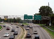
Cross Island Parkway
Encyclopedia

Parkway
The term parkway has several distinct principal meanings and numerous synonyms around the world, for either a type of landscaped area or a type of road.Type of landscaped area:...
within New York State. The parkway is a part of the Belt Parkway
Belt Parkway
The Belt System is a series of connected limited-access highways that form a belt-like circle around the New York City boroughs of Brooklyn and Queens. The system comprises four officially separate parkways; however, three of the four are signed as the Belt Parkway...
system that runs along the perimeter of the borough
Borough (New York City)
New York City, one of the largest cities in the world, is composed of five boroughs. Each borough now has the same boundaries as the county it is in. County governments were dissolved when the city consolidated in 1898, along with all city, town, and village governments within each county...
of Queens
Queens
Queens is the easternmost of the five boroughs of New York City. The largest borough in area and the second-largest in population, it is coextensive with Queens County, an administrative division of New York state, in the United States....
in New York City
New York City
New York is the most populous city in the United States and the center of the New York Metropolitan Area, one of the most populous metropolitan areas in the world. New York exerts a significant impact upon global commerce, finance, media, art, fashion, research, technology, education, and...
. The Cross Island Parkway runs 10.6 miles (17.1 km) from the Whitestone Expressway (Interstate 678) in Whitestone
Whitestone, Queens
Whitestone is a residential neighborhood in the northernmost part of the City of New York borough of Queens. Located between the East River to the north and 25th Avenue to the south. Whitestone is surrounded by College Point, Flushing, Bayside, Auburndale, Linden Hill, and Murray Hill...
past the Throgs Neck Bridge
Throgs Neck Bridge
The Throgs Neck Bridge is a suspension bridge opened on January 11, 1961, which carries Interstate 295 over the East River where it meets the Long Island Sound. The bridge connects the Throggs Neck section of the Bronx with the Bay Terrace section of Queens...
, along and across the border of Queens and Nassau County
Nassau County, New York
Nassau County is a suburban county on Long Island, east of New York City in the U.S. state of New York, within the New York Metropolitan Area. As of the 2010 census, the population was 1,339,532...
to meet up with the Southern State Parkway
Southern State Parkway
The Southern State Parkway is a long limited-access highway on Long Island, in the U.S. state of New York...
. The road is designated as New York State Route 907A, an unsigned reference route.
The Cross Island Parkway is the main route to Belmont Park
Belmont Park
Belmont Park is a major thoroughbred horse-racing facility located in Elmont in the Town of Hempstead in Nassau County, New York, on Long Island adjoining New York City. It first opened on May 4, 1905...
in Elmont
Elmont, New York
Elmont is an unincorporated census-designated place located in the northwest corner of the Town of Hempstead in Nassau County, New York, along its border with the borough of Queens in New York City...
.
Being a part of the "Belt System", its exit numbering is a continuation of the Belt Parkway
Belt Parkway
The Belt System is a series of connected limited-access highways that form a belt-like circle around the New York City boroughs of Brooklyn and Queens. The system comprises four officially separate parkways; however, three of the four are signed as the Belt Parkway...
, with exit numbers increasing north. At exit 25A (Southern State Parkway
Southern State Parkway
The Southern State Parkway is a long limited-access highway on Long Island, in the U.S. state of New York...
), the Cross Island Parkway becomes the Belt Parkway
Belt Parkway
The Belt System is a series of connected limited-access highways that form a belt-like circle around the New York City boroughs of Brooklyn and Queens. The system comprises four officially separate parkways; however, three of the four are signed as the Belt Parkway...
(more specifically, the section once known as the Laurelton Parkway). Before its exits were renumbered to align with the Belt Parkway
Belt Parkway
The Belt System is a series of connected limited-access highways that form a belt-like circle around the New York City boroughs of Brooklyn and Queens. The system comprises four officially separate parkways; however, three of the four are signed as the Belt Parkway...
, they were numbered to co-align with the Southern State Parkway
Southern State Parkway
The Southern State Parkway is a long limited-access highway on Long Island, in the U.S. state of New York...
, which is why that parkway begins with exit 13 (the Cross Island Parkway was once exits 1 to 12).
Route description
The Cross Island Parkway begins at an interchange with the Southern State ParkwaySouthern State Parkway
The Southern State Parkway is a long limited-access highway on Long Island, in the U.S. state of New York...
and the Laurelton Parkway. Exit 26A is for Belmont Park
Belmont Park
Belmont Park is a major thoroughbred horse-racing facility located in Elmont in the Town of Hempstead in Nassau County, New York, on Long Island adjoining New York City. It first opened on May 4, 1905...
in Elmont, NY, however, the exit is only northbound. Exits 26B and 26C are for the Hempstead Turnpike, also known as State Route 24
New York State Route 24
New York State Route 24 is an east–west state highway on Long Island in New York in the United States. The route is split into two segments, with the longest and westernmost of the two extending from Interstate 295 and NY 25 in the Queens Village section of the New York City...
. Exit 26D is for the northern end of Belmont Park
Belmont Park
Belmont Park is a major thoroughbred horse-racing facility located in Elmont in the Town of Hempstead in Nassau County, New York, on Long Island adjoining New York City. It first opened on May 4, 1905...
. Exit 27 is split into E and W southbound and is for State Route 25 and Jamaica Avenue. In Bellerose
Bellerose
Bellerose, may refer to:*Bellerose, New York, a village in Nassau County**Bellerose **Bellerose Village Municipal Complex*Bellerose, Queens, in New York City*Bellerose Composite High School, St. Albert, Canada...
, the Cross Island leaves Nassau County for Queens again and interchanges with Route 25B and Union Turnpike at exits 28A and B.
The speed limit throughout the entire parkway is 50 mi/h. Police services are primarily provided by the New York City Police Department Highway Patrol
New York City Police Department Highway Patrol
The New York City Police Department Highway Patrol, also known as the NYPD Highway Patrol or by the shorthand NYPD HWY, is a specialized unit under the auspices of the NYPD's Transportation Bureau primarily responsible for patrolling and maintaining traffic safety on limited-access highways within...
District 3, and, when the Highway Patrol is unavailable, the 105, 109 and 111 Precincts.
Exit list
|-|rowspan=5|Queens
|rowspan=3|Cambria Heights
Cambria Heights, Queens
Cambria Heights is a middle-class neighborhood in the southeastern portion of the New York City borough of Queens. It is bounded by Springfield Boulevard and Francis Lewis Boulevard to the west, the Elmont, Nassau County border on the east, Queens Village to the north, St. Albans to the west, and...
|0.00
|
|
|Southbound exit and northbound entrance
|-
|0.00
|25A
|
|Southbound exit and northbound entrance
|-
|
|25B
|Elmont Road, Linden Boulevard
Linden Boulevard
Linden Boulevard is a boulevard in New York City. It starts off at Flatbush Avenue in Brooklyn and stretches through both Brooklyn and Queens. This boulevard, especially the area of Cambria Heights between Springfield Boulevard and the Nassau County line represents a smaller version of shopping...
|
|-
|rowspan=2|Queens Village
Queens Village, Queens
Queens Village is mostly a residential neighborhood in the eastern part of the New York City borough of Queens.The Queens Village Post Office serves the ZIP codes of 11427 , 11428 , and 11429...
|
|26A
|Belmont Racetrack
|No southbound exit
|-
|1.56
|26B
|
|Signed as exits 26B (east) and 26C (west) southbound
|-
|rowspan=2|Nassau
|rowspan=2|Floral Park
Floral Park, New York
Floral Park is an incorporated village in Nassau County, New York, United States, on Long Island. The population as of the US Census of 2010 is 15,863. The village is at the western border of Nassau County, and is located in both the Town of Hempstead and the Town of North Hempstead...
|1.93
|26D
|Belmont Racetrack
|
|-
|2.52
|27
|
|Signed as exits 27E (east) and 27W (west) southbound
|-
|rowspan=11|Queens
|Bellerose
Bellerose, Queens
Bellerose, also called Bellerose Manor, is a neighborhood on the eastern edge of the New York City borough of Queens, near the border with Nassau County. It is sometimes referred to as Bellerose Manor, to distinguish it from the adjacent Bellerose Village and Bellerose Terrace in Nassau County,...
|3.23
|28A
|
|-
|Bellerose, Glen Oaks
Glen Oaks, Queens
Glen Oaks is a neighborhood in the easternmost portion of the New York City Borough of Queens. The neighborhood is part of Queens Community Board 13.-Location:...
|3.76
|28B
|Union Turnpike
Union Turnpike (New York)
Union Turnpike is a thoroughfare stretching across central and eastern Queens in New York City. It runs from Myrtle Avenue in Glendale to Marcus Avenue in North New Hyde Park, about a mile into Nassau County, New York. Initially designed as a toll road, it takes a straight-arrow path from Kew...
|
|-
|Bellerose, Glen Oaks, Oakland Gardens
Oakland Gardens, Queens
Oakland Gardens is a neighborhood in the northern part of the New York City borough of Queens. The neighborhood is bounded to the north by 48th Avenue, to the east by Alley Pond Park, to the south by Union Turnpike, and to the west by Cunningham Park. Bayside is to the north, and Queens Village and...
, Douglaston
Douglaston, Queens
Douglaston, population 14,168 , is a community in the New York City borough of Queens. Douglaston comprises six distinct neighborhoods: Doug Bay, Douglas Manor, and Douglaston Hill, all located north of Northern Boulevard on the peninsula abutting Little Neck Bay; Douglaston Park, located between...
|4.13
|29
|
|Signed as exits 29E (east) and 29W (west)
|-
|rowspan=2|Oakland Gardens, Douglaston
|rowspan=2|5.05
|30E
|
|
|-
|30W
|
|Northbound exit and southbound entrance
|-
|Bayside
Bayside, Queens
Bayside is a suburban neighborhood in the borough of Queens in New York, New York in the United States. Bayside is known as one of the most expensive areas to live in Queens, with well kept homes and landscaping...
, Douglaston
|5.95
|31
|
|Signed as exits 31E (east) and 31W (west)
|-
|rowspan=2|Bayside
|8.33
|32
|
|Signed as exit 33 southbound
|-
|8.83
|33
|
|Northbound exit and southbound entrance
|-
|rowspan=3|Whitestone
Whitestone, Queens
Whitestone is a residential neighborhood in the northernmost part of the City of New York borough of Queens. Located between the East River to the north and 25th Avenue to the south. Whitestone is surrounded by College Point, Flushing, Bayside, Auburndale, Linden Hill, and Murray Hill...
|9.06
|34
|160th Street, Utopia Parkway
|
|-
|
|35
|14th Avenue, Francis Lewis Boulevard
Francis Lewis Boulevard
Francis Lewis Boulevard is a boulevard in the New York City borough of Queens. The roadway is named for Francis Lewis, a Queens resident who was a signer of the United States Declaration of Independence.-Route description:...
|No northbound exit
|-
|10.57
|36
|
|Northbound exit and southbound entrance; signed as exits 36N (north) and 36S (south)