

Crimean Trolleybus
Encyclopedia
Crimean Trolleybus Line in Crimea
Crimea
Crimea , or the Autonomous Republic of Crimea , is a sub-national unit, an autonomous republic, of Ukraine. It is located on the northern coast of the Black Sea, occupying a peninsula of the same name...
, Ukraine
Ukraine
Ukraine is a country in Eastern Europe. It has an area of 603,628 km², making it the second largest contiguous country on the European continent, after Russia...
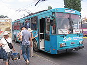
is currently the longest trolleybus
Trolleybus
A trolleybus is an electric bus that draws its electricity from overhead wires using spring-loaded trolley poles. Two wires and poles are required to complete the electrical circuit...
line in the world. It is 86 kilometres (53.4 mi) long, and runs between the autonomous republic
Autonomous republic
An autonomous republic is a type of administrative division similar to a province. A significant number of autonomous republics can be found within the successor states of the Soviet Union, but the majority are located within Russia. Many of these republics were established during the Soviet...
's capital, Simferopol
Simferopol
-Russian Empire and Civil War:The city was renamed Simferopol in 1784 after the annexation of the Crimean Khanate to the Russian Empire by Catherine II of Russia. The name Simferopol is derived from the Greek, Συμφερόπολις , translated as "the city of usefulness." In 1802, Simferopol became the...
, and the coastal city of Yalta
Yalta
Yalta is a city in Crimea, southern Ukraine, on the north coast of the Black Sea.The city is located on the site of an ancient Greek colony, said to have been founded by Greek sailors who were looking for a safe shore on which to land. It is situated on a deep bay facing south towards the Black...
on the Black Sea
Black Sea
The Black Sea is bounded by Europe, Anatolia and the Caucasus and is ultimately connected to the Atlantic Ocean via the Mediterranean and the Aegean seas and various straits. The Bosphorus strait connects it to the Sea of Marmara, and the strait of the Dardanelles connects that sea to the Aegean...
.
The trolleybus line, managed by the public transport company Krymtrolleybus, was built in 1959 in the Ukrainian SSR
Ukrainian SSR
The Ukrainian Soviet Socialist Republic or in short, the Ukrainian SSR was a sovereign Soviet Socialist state and one of the fifteen constituent republics of the Soviet Union lasting from its inception in 1922 to the breakup in 1991...
as an alternative to extending the current railway line in Simferopol over the mountains to the coastal settlements. The line was opened in two parts: the Simferopol–Alushta segment was opened in 1959 and the Alushta–Yalta segment in 1961. The journey to Alushta
Alushta
Alushta is a resort town in Crimea, Ukraine, founded in the 6th century by Emperor Justinian. It is situated on the Black Sea on the road from Gurzuf to Sudak, as well as on the Crimean Trolleybus line....
is about 1½ hours long, and the journey to Yalta is about 2½ hours long, and costs about 8 hryvnia
Ukrainian hryvnia
The hryvnia, sometimes hryvnya or grivna ; sign: ₴, code: , has been the national currency of Ukraine since September 2, 1996. The hryvnia is subdivided into 100 kopiyok. In medieval times, it was a currency of Kievan Rus'....
s.
The trolleybus line's route passes through the Crimean Mountains
Yayla Mountains
The Crimean Mountains is a range of mountains running parallel to the south-east coast of Crimea, Ukraine, between about five and eight miles from the sea...
across the Angarskyi Pass
Angarskyi Pass
The Angarskyi Pass is a mountain pass of the Crimean Mountains on the Crimean peninsula of southern Ukraine. The pass is the highest point on the Simferopol–Alushta roadway, at above sea level. It takes its name from the Angara River, a tributary of the Salhir.During the Middle Ages, only a small...
, reaching 752 metres (2,467.2 ft) at the road's highest point, then descends down to the resort town of Alushta on the coast. The remaining distance to Yalta is 41 kilometres (25.5 mi) and winds around the mountains above the sea.
The Škoda 9Tr
Škoda Works
Škoda Works was the largest industrial enterprise in Austro-Hungary and later in Czechoslovakia, one of its successor states. It was also one of the largest industrial conglomerates in Europe in the 20th century...
and Škoda 14Tr
Škoda Works
Škoda Works was the largest industrial enterprise in Austro-Hungary and later in Czechoslovakia, one of its successor states. It was also one of the largest industrial conglomerates in Europe in the 20th century...
vehicles are used on the route, although starting from 2010 newer Bogdan T601-11
Bogdan (bus)
Bohdan is the brand of the Ukrainian buses and trolleybuses made by Bogdan Corporation. The original two front-engine/rear-wheel drive models are powered by Isuzu and marketed outside Ukraine under Isuzu brand. Large city buses, such as the rear-engined Bohdan A145 and Bohdan A1445, are also...
trolleybuses started to replace the aged Škoda vehicles.
External links
- Krym State Production Enterprise "Krymtrolleybus" - official website