

Cow Creek (Montana)
Encyclopedia
Cow Creek is a tributary
of the Missouri River
, approximately 35 miles (56.3 km) long, in north central Montana
in the United States. Cow Creek rises in the southern foothills of the Bear Paw Mountains
in western Blaine County
and flows east and then south, joining the Missouri approximately 25 miles (40.2 km) air miles northeast of Winifred, Montana
-- or 22 miles (35.4 km) miles upstream from the Fred Robinson Bridge. Cow Creek flows down to the Missouri in a canyon that passes through the Missouri Breaks, which are severely eroded badlands that extend out on either side from the Missouri River. The floor of Cow Creek canyon provided a pathway of travel from the Montana plains north of the river, down to the Missouri – at the mouth of Cow Creek, Cow Island made fording the Missouri easier – a steep but short trail on the south bank of the Missouri opposite Cow Creek completed this route which led from the northern Montana plains to the central and southern Montana plains. This pathway was used by migrating buffalo/bison and nomadic American Natives for centuries. During the steamboat era on the Missouri River, when low water prevented riverboats getting up to Fort Benton, the mouth of Cow Creek became a river landing and freighting depot, and it was the start of the Cow Island Trail by which freight was moved on to Fort Benton by going north up Cow Creek and then west. In 1877 the Nez Perce Indian Tribe, fleeing to Canada, had several skirmishes along Cow Creek including the "Battle of Cow Island", and several days later at a camp on Cow Creek the Nez Perce, thinking themselves now beyond the reach of the U.S. Army, made the fateful decision to slow down, rather than push on for the Canadian border. Today, modern highways have by passed Cow Creek, and the buffalo and the nomadic Indian are gone. Cow Creek is dormant, in one of the most remote spots of the isolated regions of the vast area known as the Montana Missouri Breaks.
of the Bear Paw Mountains
to the Missouri
through a unique and remote area known as the Missouri Breaks. The breaks are extensive and steeply eroded badlands
. They are so rough that they are a barrier
to travel by animals or man. They extend along the Missouri River
for over 200 miles (321.9 km). In this long stretch of river the Missouri Breaks extend back from the river on either side, for many miles. As the Missouri flows through this 200 mile stretch, the breaks limit access to the river from the wide undulating grasslands north and south of the river.
Cow Creek provides one of the few access routes down to the Missouri River
through the Missouri Breaks. As Cow Creek flows through the breaks it passes between high canyon
like walls, but the stream meanders back and forth over a canyon floor that is relatively level and from 100 to 600 yd (91.4 to 548.6 ) in width.
The canyon bottom along Cow Creek creates a corridor of travel from the northern Montana plains down to the river through the breaks. Sediments seasonally washed out from the mouth of Cow Creek into the Missouri River formed Cow Island, just downriver from the creek mouth. Cow Island divides the Missouri into two channels, which makes crossing the broad Missouri easier at this point. On the south side of the river opposite the Cow Island, a steep but relatively short 4 mile climb out of the breaks gains the wide plains of Central Montana south of the river.
This combination of geographic features made Cow Creek and the ford at Cow Island an ancient highway of travel. For thousands of years, Cow Creek and the Cow Island ford was used by migrating buffalo herds and other migrating animals, and by nomadic Native Americans bent on going between the plains north of the Missouri River Breaks and the plains lying south of the Missouri Breaks.
The final 1300 miles (2,092.1 km) of the river was called the "upper Missouri" – this stretch traversed remote unsettled plains, and the last few hundred miles to Ft. Benton passed through the Missouri Breaks. In May and June the Missouri River has "high water" from mountain snow melt, and steamboats who caught this flood could travel all the way through the breaks to reach the upriver terminus at Ft. Benton. Later, in the summer and fall the water levels dropped, and there was "low water" on the upper Missouri. When "low water" came, deeper draft steamboats often could not reach Ft. Benton, and they had to drop their cargos downstream in the Missouri Breaks.
Each year during the steam boat era, in the late summer and fall Cow Island and the mouth of Cow Creek became a river port, known as Cow Island landing. The mouth of Cow Cree is 126 river miles below Ft. Benton. Some 24 miles above Cow Island was Dauphine Rapids, which was difficult to run even in high water, but was a deadly barrier to riverboats in low water. In the stretch of river below Dauphine Rapids, Cow Island landing was the only place from which freight could be offloaded and then transported overland to Ft. Benton, via the Cow Island Trail.
To offload cargo at Cow island, the steamboats used a landing point several hundred yards above Cow Creek, in front of the now abandoned buildings of the Kipp homestead (see photo), or down river, several hundreds of yards below Cow Creek. The steamboats used landing sites where the water of the Missouri was deep up against the north bank, so the river boats could pull in close to the bank to discharge cargo.
From year to year, and month to month the volume of freight on the Cow Island Trail fluctuated depending on whether the riverboats had high water so they could get up river to Fort Benton, or whether low water over the Dauphine and other rapids caused riverboats to offload at Cow Island Landing. Starting in 1863 the Cow Island Trail had high volumes of freight traffic. 1863 was a low water year, and word was spreading that there were rich strikes in Montana Territory gold fields. In 1866 there was good water till July, so freight volume declined. 1868 was a different story. By year end, 2,500 men, 3,000 teams and 20,000 oxen ere involved in freighting on the Cow Island Trail to Ft. Benton.
No permanent storehouses were erected at Cow Island. Once freight was offloaded at Cow Island, it was tarped and remained only briefly before being moved to Ft. Benton. The high profits on freight could only be realized once the goods had gotten to Ft. Benton. A common outfit on the trail was 2 wagons, each pulled by six to eight oxen, with two bullwhackers. Oxen were preferred over horses and mules because they required less food and water, did not wander during storms, and "Indians didn't steal them because they couldn't ride them and they were to tough to eat".
The Cow Creek Trail was far from ideal, and carrying freight to Fr. Benton was never an easy task. In the confines of Cow Creek's narrow but relatively flat creek bottom, the creek meanders from one steep coulee sidewall to the other. While traveling the 15 miles up Cow Creek the heavy freight wagons had to ford Cow Creek 31 times. The fords would wash out if the area had a heavy rain. In wetter weather heavy wagons could bog down at a creek crossing. After going 15 miles up the creek bottom, the freighters encountered long steep grades. The freighters had to stop, unhitch and "double team" or even "triple team" each of the wagons. In 1864 while ascending a steep grade on the trail, a wagon ran its outside wheels off the trail and went over, dragging the ox team with it. The descent of 300 feet killed the oxen, badly damaged the wagon and scattered its contents.
 Fifty tons of freight, which had been offloaded from steamboats, lay under tarpaulins at the landing awaiting shipment by wagon to Fort Benton or other remote corners of the Montana Territory.
The Nez Perce crossed the Missouri at several places. The group observed by soldiers first sent an advance guard of 20 or so warriors across, who spread out on the north bank. Then the women and children crossed with pack animals and camp equipment, and finally a rear guard of warriors crossed.
Several armed encounters involving the Nez Perce occurred on Cow Creek, but the most important event was the fateful decision made while in camp on Cow Creek on September 25, 1877.
After crossing the river, the main body of the Nez Perce went past the soldiers without incident, and camped about two miles up Cow Creek. A small group of Nez Perce rode to the entrenchment. They indicated friendly intentions and asked for some of the stockpiled food. The army sergeant in charge at first ignored their request which reduced the Nez Perce to begging. Finally the sergeant gave them one bag of hardtack and one side of bacon from the soldier's own stores. At sundown gunfire broke from Indians in the breaks, who had located themselves so they could fire down into the entrenchment. Two civilians were wounded and the soldiers, though able to return fire, were now pinned down. The supplies were far enough from the entrenchment so that, as night fell, the Indians could filter out of the steep eroded breaks and get to the supplies without coming under effective fire. After dark the Indians broke into the supplies, and took what they found desirable in the dark. The supplies were set on fire. A large stockpile of bacon burned brightly for most of the night. The soldiers attributed the illumination from this blaze with preventing a concerted attack, but it is more likely that the Nez Perce only wanted the supplies and not a pitched battle with the soldiers. The Indians and the soldiers exchanged sporadic gunfire through the night until about 10:00 in the morning, after which the Nez Perce moved off up Cow Creek. Two civilians and one Nez Perce warrior were wounded.
On the morning of September 25, a small army relief force under Major Guido Igles approached the rear of the Nez Perce assemblage on Cow Creek. Major Igles had come from Ft. Benton to the aid of the outpost at Cow Island Landing. He was leading a handful of soldiers and civilian volunteers from Ft. Benton. After reaching Cow Island on September 24, he had continued on the trail of the Nez Perce.
When the Nez Perce discovered Major Igles coming up Cow Creek, some warriors went down the canyon to take up positions to meet this threat. Other Nez Perce attacked the wagon train. One teamster was killed and the others fled into willows along the creek or into the breaks. The main body of the Nez Perce helped themselves to some goods in the wagons, set them on fire, and continued on up Cow Creek.
Meanwhile, the Nez Perce warriors forming the rear guard had taken up positions on heights facing Major Igles small force which was down in Cow Creek canyon. Firing broke out. The Nez Perce were in a position to fire into Igles position. One civilian was killed. Another was saved when a bullet was deflected by his belt buckle, bruising his abdomen. After two hours, the Nez Perce broke off the engagement. Fearing an ambush and knowing he was greatly outnumbered, Major Igles began a slow and cautious withdrawal to Cow Island Landing. He reported two Nez Perce wounded in the encounter.
On the night of September 25 the steamer Benton arrived at Cow Island Landing, discharging fifty tons of freight, and the steamer Silver City approached with an additional one hundred tons. Major Igles sent couriers reporting the Nez Perce location to General Miles who was advancing cross country from Ft. Keogh with fresh troops to intercept the Nez Perce.
Just upstream from the mouth of Cow Creek, the Kipp homestead lies in Cow Creek bottom. It is adjacent to the site of the old upper steamboat landing, above the mouth of Cow Creek. One source reports that the Kipp homestead was originally filed by the historic figure James Kipp (1788–1880) and was lived in by his son, Joseph and then his grandson, James Kipp, but that this Kipp homestead and the homestead downriver on Bull Creek became the property of the Jones family, related by marriage to the Kipp family. Another source indicates the homestead was claimed by Jim Kipp in 1913. Jim was the son of Joseph Kipp (1849–1913) who was the son of the historic figure James Kipp (1788–1880) and his wife Earth Woman.
The elder historic James Kipp (1788–1880) helped establish Ft. Union at the mouth of the Yellowstone in 1828 and he also founded Ft. Piegan at the mouth of the Marias River in 1831. The Kipp homestead is abandoned but a few cabins and outbuildings remain standing at the homestead site.
Just downstream from the mouth of Cow Creek is the mouth of Bull Creek. Here on Bull Creek bottom is another abandoned homestead with decaying and collapsing log buildings, and the debris from failed farming efforts. This homestead is attributed to the Jones family, related by marriage to the Kipp family.
Road access to both homesteads was along a primitive road that traveled downstream along the Missouri on the north side of the river to the site of a power plant. This road was still passable from the power plant site to Cow Creek a few years ago. During the homesteading years, one of the few ferries in the Missouri breaks operated at the site of the power plant. From the power plant ferry a road went north to the Zortman area, and another road went south toward Lewistown, Montana.
Cow Creek is now one of the more remote and uninhabited spots in an area – the Missouri Breaks – notorious for its isolation. This condition is recognized by the United States Bureau of Land Management (BLM), which is currently considering the lower portion of Cow Creek for wilderness status.
The abandoned buildings of the Kipp homestead on Cow Creek bottom and the homestead on Bull bottom continue to deteriorate. For many years a snubbing post, used to tie up steamboats, was buried in the river bank between the Kipp homestead and the river. The snubbing post may have since washed into the river. It is reported that the remains of the entrenchments are still visible that used by the soldiers in the 1877 skirmish with the Nez Perce that is now known as the "Battle of Cow Island". For many years the metal wreckage from wagons burned by the Nez Perce on September 25, 1877 could be seen in Cow Creek canyon. An unsupported (and very likely apocryphal) local rumor developed that the wagon train had been carrying gold and it was taken by the Nez Perce and buried in the vicinity.
Lower Cow Creek, where the deserted homesteads are located, is difficult to visit. A mostly dirt surfaced BLM road runs west from Montana Highway 66 for 14 miles (22.5 km), before dropping down into Bull Creek. Bull Creek joins the Missouri very near Cow Island, and from Bull Creek one can get to the adjacent mouth of Cow Creek. In the descent from the high ridges of the breaks into the Missouri bottom at Bull Creek, this road has steep rutted inclines and several switchbacks. The road is often cut into the side of steep cliffs. This stretch is sharply eroded with washouts, and there are precious few places to turn around, if the traveler decides he has had enough.
As for the old freight trail that went upstream from the mouth of Cow Creek, there is no longer any road to speak of in the first 15 miles. The multiple creek crossings of the old Cow Creek trail have been eroded away into cut banks, and the gravel bars where the wagons crossed have been swept down stream. Here and there the remnants of the old Cow Creek Trail can be observed along Cow Creek but it is sketchy. Upper Cow Creek is not so isolated. About 15 miles up from the Missouri, where Davidson Coulee flows into Cow Creek, Blaine County Road 330 (Cow Creek Trail) drops down Davidson ridge to Cow Creek Bottom from the west. One ranch is located near this point. The name "Cow Island Trail" is still applied to the road that goes from the junction of Cow Creek and Davidson Coulee up to the bench and on to the west, and this is probably the same route that the original Cow Island freight trail followed as it went on to Ft. Benton. Above Davidson Coulee Cow Creek is paralleled by Blain County Road 314 (Birdtail Road) for about 6 miles (10 km). In the upper reaches of Cow Creek a County road (Birdtail Road) descends to a second ranch. Blaine County Road 300 crosses Cow Creek at it upper end, near the forks of West and East Cow Creek, just under the southern flank of the Bears Paw Mountains.
Most of the roads in the breaks are simply dirt roads. Only a few are graveled. Dirt roads in the Cow Creek area (as well as most of the Missouri Breaks) can be traversed only with extreme difficulty (if at all) when wet. The breaks are partially eroded from clays of the Cretaceous formations which contain bentonite. When wet the surface of these clays becomes slick and then becomes "gumbo" which clings to and builds up on tires, wheels, feet and hooves. If caught on dirt roads in the breaks by rain the best (and sometimes the only) course is to simply wait till the surface dries out.
Tributary
A tributary or affluent is a stream or river that flows into a main stem river or a lake. A tributary does not flow directly into a sea or ocean...
of the Missouri River
Missouri River
The Missouri River flows through the central United States, and is a tributary of the Mississippi River. It is the longest river in North America and drains the third largest area, though only the thirteenth largest by discharge. The Missouri's watershed encompasses most of the American Great...
, approximately 35 miles (56.3 km) long, in north central Montana
Montana
Montana is a state in the Western United States. The western third of Montana contains numerous mountain ranges. Smaller, "island ranges" are found in the central third of the state, for a total of 77 named ranges of the Rocky Mountains. This geographical fact is reflected in the state's name,...
in the United States. Cow Creek rises in the southern foothills of the Bear Paw Mountains
Bear Paw Mountains
The Bear Paw Mountains are an insular-montane island range in North-Central Montana, USA, located approximately 10 miles south of Havre, Montana...
in western Blaine County
Blaine County, Montana
-National protected areas:* Black Coulee National Wildlife Refuge* Nez Perce National Historical Park * Upper Missouri River Breaks National Monument -Economy:The main industry in Blaine County is Agriculture...
and flows east and then south, joining the Missouri approximately 25 miles (40.2 km) air miles northeast of Winifred, Montana
Winifred, Montana
Winifred is a town in north-central Fergus County, Montana, United States. The population was 156 at the 2000 census. Winifred was founded in 1913 as the terminus of a newly-built branch line of the Chicago, Milwaukee, St. Paul and Pacific Railroad...
-- or 22 miles (35.4 km) miles upstream from the Fred Robinson Bridge. Cow Creek flows down to the Missouri in a canyon that passes through the Missouri Breaks, which are severely eroded badlands that extend out on either side from the Missouri River. The floor of Cow Creek canyon provided a pathway of travel from the Montana plains north of the river, down to the Missouri – at the mouth of Cow Creek, Cow Island made fording the Missouri easier – a steep but short trail on the south bank of the Missouri opposite Cow Creek completed this route which led from the northern Montana plains to the central and southern Montana plains. This pathway was used by migrating buffalo/bison and nomadic American Natives for centuries. During the steamboat era on the Missouri River, when low water prevented riverboats getting up to Fort Benton, the mouth of Cow Creek became a river landing and freighting depot, and it was the start of the Cow Island Trail by which freight was moved on to Fort Benton by going north up Cow Creek and then west. In 1877 the Nez Perce Indian Tribe, fleeing to Canada, had several skirmishes along Cow Creek including the "Battle of Cow Island", and several days later at a camp on Cow Creek the Nez Perce, thinking themselves now beyond the reach of the U.S. Army, made the fateful decision to slow down, rather than push on for the Canadian border. Today, modern highways have by passed Cow Creek, and the buffalo and the nomadic Indian are gone. Cow Creek is dormant, in one of the most remote spots of the isolated regions of the vast area known as the Montana Missouri Breaks.
Cow Creek as an Ancient Corridor of Travel -- Cow Island Ford
Cow Creek flows from the southern foothillsFoothills
Foothills are geographically defined as gradual increases in elevation at the base of a mountain range. They are a transition zone between plains and low relief hills to the adjacent topographically high mountains.-Examples:...
of the Bear Paw Mountains
Bear Paw Mountains
The Bear Paw Mountains are an insular-montane island range in North-Central Montana, USA, located approximately 10 miles south of Havre, Montana...
to the Missouri
Missouri River
The Missouri River flows through the central United States, and is a tributary of the Mississippi River. It is the longest river in North America and drains the third largest area, though only the thirteenth largest by discharge. The Missouri's watershed encompasses most of the American Great...
through a unique and remote area known as the Missouri Breaks. The breaks are extensive and steeply eroded badlands
Badlands
A badlands is a type of dry terrain where softer sedimentary rocks and clay-rich soils have been extensively eroded by wind and water. It can resemble malpaís, a terrain of volcanic rock. Canyons, ravines, gullies, hoodoos and other such geological forms are common in badlands. They are often...
. They are so rough that they are a barrier
Barrier
A barrier or barricade is a physical structure which blocks or impedes something.Barrier may also refer to:-Physical barriers:* Automatic full barriers, which serve to block roads at railway crossings...
to travel by animals or man. They extend along the Missouri River
Missouri River
The Missouri River flows through the central United States, and is a tributary of the Mississippi River. It is the longest river in North America and drains the third largest area, though only the thirteenth largest by discharge. The Missouri's watershed encompasses most of the American Great...
for over 200 miles (321.9 km). In this long stretch of river the Missouri Breaks extend back from the river on either side, for many miles. As the Missouri flows through this 200 mile stretch, the breaks limit access to the river from the wide undulating grasslands north and south of the river.
Cow Creek provides one of the few access routes down to the Missouri River
Missouri River
The Missouri River flows through the central United States, and is a tributary of the Mississippi River. It is the longest river in North America and drains the third largest area, though only the thirteenth largest by discharge. The Missouri's watershed encompasses most of the American Great...
through the Missouri Breaks. As Cow Creek flows through the breaks it passes between high canyon
Canyon
A canyon or gorge is a deep ravine between cliffs often carved from the landscape by a river. Rivers have a natural tendency to reach a baseline elevation, which is the same elevation as the body of water it will eventually drain into. This forms a canyon. Most canyons were formed by a process of...
like walls, but the stream meanders back and forth over a canyon floor that is relatively level and from 100 to 600 yd (91.4 to 548.6 ) in width.
The canyon bottom along Cow Creek creates a corridor of travel from the northern Montana plains down to the river through the breaks. Sediments seasonally washed out from the mouth of Cow Creek into the Missouri River formed Cow Island, just downriver from the creek mouth. Cow Island divides the Missouri into two channels, which makes crossing the broad Missouri easier at this point. On the south side of the river opposite the Cow Island, a steep but relatively short 4 mile climb out of the breaks gains the wide plains of Central Montana south of the river.
This combination of geographic features made Cow Creek and the ford at Cow Island an ancient highway of travel. For thousands of years, Cow Creek and the Cow Island ford was used by migrating buffalo herds and other migrating animals, and by nomadic Native Americans bent on going between the plains north of the Missouri River Breaks and the plains lying south of the Missouri Breaks.
Cow Creek as a River Port – Cow Island Landing
Once gold was discovered in the Montana Territory in 1862, the Missouri River became the most reliable pathway to bring passengers and freight—particularly heavy or bulky freight—to the booming gold fields. In the era from 1860 the mid 1880's steamboats brought supplies and heavy equipment some 2600 miles (4,184.3 km) from ports like St. Louis in "the states" to the upriver terminus port of Ft. Benton in the Montana Territory.The final 1300 miles (2,092.1 km) of the river was called the "upper Missouri" – this stretch traversed remote unsettled plains, and the last few hundred miles to Ft. Benton passed through the Missouri Breaks. In May and June the Missouri River has "high water" from mountain snow melt, and steamboats who caught this flood could travel all the way through the breaks to reach the upriver terminus at Ft. Benton. Later, in the summer and fall the water levels dropped, and there was "low water" on the upper Missouri. When "low water" came, deeper draft steamboats often could not reach Ft. Benton, and they had to drop their cargos downstream in the Missouri Breaks.
Each year during the steam boat era, in the late summer and fall Cow Island and the mouth of Cow Creek became a river port, known as Cow Island landing. The mouth of Cow Cree is 126 river miles below Ft. Benton. Some 24 miles above Cow Island was Dauphine Rapids, which was difficult to run even in high water, but was a deadly barrier to riverboats in low water. In the stretch of river below Dauphine Rapids, Cow Island landing was the only place from which freight could be offloaded and then transported overland to Ft. Benton, via the Cow Island Trail.
To offload cargo at Cow island, the steamboats used a landing point several hundred yards above Cow Creek, in front of the now abandoned buildings of the Kipp homestead (see photo), or down river, several hundreds of yards below Cow Creek. The steamboats used landing sites where the water of the Missouri was deep up against the north bank, so the river boats could pull in close to the bank to discharge cargo.
The Cow Island Trail up Cow Creek, and Freighting to Fort Benton, Montana
The wagon road that started at Cow Island Landing and went up Cow Creek, then out onto broad grassy plains and on to Ft. Benton, was called the Cow Island Trail. This road up Cow Creek traversed the only possible team-and-wagon route in this part of the rough badlands known as the Missouri Breaks. At 35 miles long, Cow Creek is one of the longer Missouri tributaries in the breaks. It extends north to the Bearpaw Mountains where it receives seasonal spring snow melt. Over many millenniums, this greater seasonal discharge eroded and widened the creek bottom so it became flat enough for a team and wagon to traverse. From the steamboat landing on the Missouri, the trail went north up the Cow Creek bottom for 15 miles (24.1 km) miles to Davidson Coulee, at which time the trail turned west and climbed up a long steep grade on Davidson Ridge to reach the plains north of the Missouri River Breaks.From year to year, and month to month the volume of freight on the Cow Island Trail fluctuated depending on whether the riverboats had high water so they could get up river to Fort Benton, or whether low water over the Dauphine and other rapids caused riverboats to offload at Cow Island Landing. Starting in 1863 the Cow Island Trail had high volumes of freight traffic. 1863 was a low water year, and word was spreading that there were rich strikes in Montana Territory gold fields. In 1866 there was good water till July, so freight volume declined. 1868 was a different story. By year end, 2,500 men, 3,000 teams and 20,000 oxen ere involved in freighting on the Cow Island Trail to Ft. Benton.
No permanent storehouses were erected at Cow Island. Once freight was offloaded at Cow Island, it was tarped and remained only briefly before being moved to Ft. Benton. The high profits on freight could only be realized once the goods had gotten to Ft. Benton. A common outfit on the trail was 2 wagons, each pulled by six to eight oxen, with two bullwhackers. Oxen were preferred over horses and mules because they required less food and water, did not wander during storms, and "Indians didn't steal them because they couldn't ride them and they were to tough to eat".
The Cow Creek Trail was far from ideal, and carrying freight to Fr. Benton was never an easy task. In the confines of Cow Creek's narrow but relatively flat creek bottom, the creek meanders from one steep coulee sidewall to the other. While traveling the 15 miles up Cow Creek the heavy freight wagons had to ford Cow Creek 31 times. The fords would wash out if the area had a heavy rain. In wetter weather heavy wagons could bog down at a creek crossing. After going 15 miles up the creek bottom, the freighters encountered long steep grades. The freighters had to stop, unhitch and "double team" or even "triple team" each of the wagons. In 1864 while ascending a steep grade on the trail, a wagon ran its outside wheels off the trail and went over, dragging the ox team with it. The descent of 300 feet killed the oxen, badly damaged the wagon and scattered its contents.
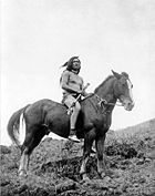
September, 1877 – The Nez Perce and Cow Creek
On September 23, 1877 several hundred Nez Perce crossed the Missouri at Cow Creek in their flight toward Canada. An army garrison of twelve men under Sergeant William Molchert was at Cow Island Landing, along with four civilian clerks who represented freighting interests in the region.The Nez Perce crossed the Missouri at several places. The group observed by soldiers first sent an advance guard of 20 or so warriors across, who spread out on the north bank. Then the women and children crossed with pack animals and camp equipment, and finally a rear guard of warriors crossed.
Several armed encounters involving the Nez Perce occurred on Cow Creek, but the most important event was the fateful decision made while in camp on Cow Creek on September 25, 1877.
The Battle of Cow Island Landing
The squad of soldiers at Cow Island Landing on September 23, 1887 had been sent to guard the stockpiled supplies, which had been offloaded from steamboats. Upon the arrival of the Nez Perce, the soldiers and the clerks retreated into an earthen entrenchment which had been built around their tents to divert rain water. The entrenchment was a few hundred yards from the ford. Significantly the entrenchment was also a few hundred yards from the stacked supplies.After crossing the river, the main body of the Nez Perce went past the soldiers without incident, and camped about two miles up Cow Creek. A small group of Nez Perce rode to the entrenchment. They indicated friendly intentions and asked for some of the stockpiled food. The army sergeant in charge at first ignored their request which reduced the Nez Perce to begging. Finally the sergeant gave them one bag of hardtack and one side of bacon from the soldier's own stores. At sundown gunfire broke from Indians in the breaks, who had located themselves so they could fire down into the entrenchment. Two civilians were wounded and the soldiers, though able to return fire, were now pinned down. The supplies were far enough from the entrenchment so that, as night fell, the Indians could filter out of the steep eroded breaks and get to the supplies without coming under effective fire. After dark the Indians broke into the supplies, and took what they found desirable in the dark. The supplies were set on fire. A large stockpile of bacon burned brightly for most of the night. The soldiers attributed the illumination from this blaze with preventing a concerted attack, but it is more likely that the Nez Perce only wanted the supplies and not a pitched battle with the soldiers. The Indians and the soldiers exchanged sporadic gunfire through the night until about 10:00 in the morning, after which the Nez Perce moved off up Cow Creek. Two civilians and one Nez Perce warrior were wounded.
The Rear Guard Action between Major Igles and Nez Perce, and the Wagon Train Attack by Nez Perce on Cow Creek on September 25, 1877
On September 22, 1877, before the arrival of the Nez Perce, a wagon train had left Cow Island Landing with 35 tons of freight and a herd of cattle, heading up Cow Island Trail for Ft. Benton. On September 24 while still in Cow Island Canyon, the train was overtaken by the Nez Perce who approached them unthreateningly and camped one and one half miles away. That evening some Nez Perce visited the camp of the wagon train and there were civil exchanges between the members of the wagon train and the Nez Perce who wanted to trade for ammunition and other goods.On the morning of September 25, a small army relief force under Major Guido Igles approached the rear of the Nez Perce assemblage on Cow Creek. Major Igles had come from Ft. Benton to the aid of the outpost at Cow Island Landing. He was leading a handful of soldiers and civilian volunteers from Ft. Benton. After reaching Cow Island on September 24, he had continued on the trail of the Nez Perce.
When the Nez Perce discovered Major Igles coming up Cow Creek, some warriors went down the canyon to take up positions to meet this threat. Other Nez Perce attacked the wagon train. One teamster was killed and the others fled into willows along the creek or into the breaks. The main body of the Nez Perce helped themselves to some goods in the wagons, set them on fire, and continued on up Cow Creek.
Meanwhile, the Nez Perce warriors forming the rear guard had taken up positions on heights facing Major Igles small force which was down in Cow Creek canyon. Firing broke out. The Nez Perce were in a position to fire into Igles position. One civilian was killed. Another was saved when a bullet was deflected by his belt buckle, bruising his abdomen. After two hours, the Nez Perce broke off the engagement. Fearing an ambush and knowing he was greatly outnumbered, Major Igles began a slow and cautious withdrawal to Cow Island Landing. He reported two Nez Perce wounded in the encounter.
On the night of September 25 the steamer Benton arrived at Cow Island Landing, discharging fifty tons of freight, and the steamer Silver City approached with an additional one hundred tons. Major Igles sent couriers reporting the Nez Perce location to General Miles who was advancing cross country from Ft. Keogh with fresh troops to intercept the Nez Perce.
The Nez Perce Council on Cow Creek on September 25, 1877, and the Fateful Decision by the Nez Perce to Stop to Rest
When the Nez Perce started up Cow Creek, they were only 80 miles (128.7 km) from Canada. While camped on Cow Creek on the evening of September 25 following the skirmish with Major Igles dissention broke out among the Nez Perce leadership between those who wanted to press on and those who wanted to slow to rest tired and weakened people and horses. The Nez Perce believed the soldiers were now far behind them. They were unaware that General Miles was coming cross country from Ft. Keogh as fast as his troops could travel. Those who wanted to go slower won out. Because the Nez Perce paused instead of pressing ahead, on September 30, General Miles' column caught up with the Nez Perce who were camped on Snake Creek east of the Bear Paw Mountains, just 40 miles (64.4 km) from Canada. Miles immediately attacked. On October 5, 1877 after five days of fighting, and with Nez Perce men, women and children suffering and dying from wounds and exposure to freezing weather, Chief Joseph surrendered the Nez Perce to the U.S. Army commanders.Overview of Nez Perce Events on Cow Creek
The capture of the Nez Perce occurred because they delayed in crossing the Canadian border, allowing General Miles to catch up to them with a fresh force of soldiers, who were superior in number and firepower. The events, "battles" and skirmishes on Cow Creek added to the overall delay, allowing General Miles to close the gap. However the deciding factor that determined the fate of the Nez Perce was the fateful decision made during the tribal council on the evening of September 25, 1877 while in camp along Cow Creek.Homesteading on the Missouri River Bottoms at the Mouth of Cow Creek and Bull Creek
Where small creeks or streams emerge from the breaks to meet the Missouri, there are broad riverside "bottoms" with meadows and cottonwoods. Cow Creek opens to such a bottom at its junction with the Missouri, and further downstream Bull Creek opens up another bottom as it flows into the Missouri.Just upstream from the mouth of Cow Creek, the Kipp homestead lies in Cow Creek bottom. It is adjacent to the site of the old upper steamboat landing, above the mouth of Cow Creek. One source reports that the Kipp homestead was originally filed by the historic figure James Kipp (1788–1880) and was lived in by his son, Joseph and then his grandson, James Kipp, but that this Kipp homestead and the homestead downriver on Bull Creek became the property of the Jones family, related by marriage to the Kipp family. Another source indicates the homestead was claimed by Jim Kipp in 1913. Jim was the son of Joseph Kipp (1849–1913) who was the son of the historic figure James Kipp (1788–1880) and his wife Earth Woman.
The elder historic James Kipp (1788–1880) helped establish Ft. Union at the mouth of the Yellowstone in 1828 and he also founded Ft. Piegan at the mouth of the Marias River in 1831. The Kipp homestead is abandoned but a few cabins and outbuildings remain standing at the homestead site.
Just downstream from the mouth of Cow Creek is the mouth of Bull Creek. Here on Bull Creek bottom is another abandoned homestead with decaying and collapsing log buildings, and the debris from failed farming efforts. This homestead is attributed to the Jones family, related by marriage to the Kipp family.
Road access to both homesteads was along a primitive road that traveled downstream along the Missouri on the north side of the river to the site of a power plant. This road was still passable from the power plant site to Cow Creek a few years ago. During the homesteading years, one of the few ferries in the Missouri breaks operated at the site of the power plant. From the power plant ferry a road went north to the Zortman area, and another road went south toward Lewistown, Montana.
Cow Creek Today
Once an ancient and much used highway for migrating animals and nomadic natives, Cow Creek and the Cow Island Crossing has been reduced to dormant inactivity by the passage of time. The migrating herds of buffalo were hunted to near extinction. The nomadic Native Americans were all placed on reservations, all long removed from Cow Creek. Railroads put an end to the Missouri River steamboat. The Missouri Breaks homesteader went broke or just got discouraged and left. Highway projects through the breaks chose more conveniently located routes than Cow Island or Cow Creek. A few ranches remain along the 35 mile extent of Cow Creek, and these are in the upper portion of the creek, in or near the foothills of the Bear Paw Mountains.Cow Creek is now one of the more remote and uninhabited spots in an area – the Missouri Breaks – notorious for its isolation. This condition is recognized by the United States Bureau of Land Management (BLM), which is currently considering the lower portion of Cow Creek for wilderness status.
The abandoned buildings of the Kipp homestead on Cow Creek bottom and the homestead on Bull bottom continue to deteriorate. For many years a snubbing post, used to tie up steamboats, was buried in the river bank between the Kipp homestead and the river. The snubbing post may have since washed into the river. It is reported that the remains of the entrenchments are still visible that used by the soldiers in the 1877 skirmish with the Nez Perce that is now known as the "Battle of Cow Island". For many years the metal wreckage from wagons burned by the Nez Perce on September 25, 1877 could be seen in Cow Creek canyon. An unsupported (and very likely apocryphal) local rumor developed that the wagon train had been carrying gold and it was taken by the Nez Perce and buried in the vicinity.
Lower Cow Creek, where the deserted homesteads are located, is difficult to visit. A mostly dirt surfaced BLM road runs west from Montana Highway 66 for 14 miles (22.5 km), before dropping down into Bull Creek. Bull Creek joins the Missouri very near Cow Island, and from Bull Creek one can get to the adjacent mouth of Cow Creek. In the descent from the high ridges of the breaks into the Missouri bottom at Bull Creek, this road has steep rutted inclines and several switchbacks. The road is often cut into the side of steep cliffs. This stretch is sharply eroded with washouts, and there are precious few places to turn around, if the traveler decides he has had enough.
As for the old freight trail that went upstream from the mouth of Cow Creek, there is no longer any road to speak of in the first 15 miles. The multiple creek crossings of the old Cow Creek trail have been eroded away into cut banks, and the gravel bars where the wagons crossed have been swept down stream. Here and there the remnants of the old Cow Creek Trail can be observed along Cow Creek but it is sketchy. Upper Cow Creek is not so isolated. About 15 miles up from the Missouri, where Davidson Coulee flows into Cow Creek, Blaine County Road 330 (Cow Creek Trail) drops down Davidson ridge to Cow Creek Bottom from the west. One ranch is located near this point. The name "Cow Island Trail" is still applied to the road that goes from the junction of Cow Creek and Davidson Coulee up to the bench and on to the west, and this is probably the same route that the original Cow Island freight trail followed as it went on to Ft. Benton. Above Davidson Coulee Cow Creek is paralleled by Blain County Road 314 (Birdtail Road) for about 6 miles (10 km). In the upper reaches of Cow Creek a County road (Birdtail Road) descends to a second ranch. Blaine County Road 300 crosses Cow Creek at it upper end, near the forks of West and East Cow Creek, just under the southern flank of the Bears Paw Mountains.
Most of the roads in the breaks are simply dirt roads. Only a few are graveled. Dirt roads in the Cow Creek area (as well as most of the Missouri Breaks) can be traversed only with extreme difficulty (if at all) when wet. The breaks are partially eroded from clays of the Cretaceous formations which contain bentonite. When wet the surface of these clays becomes slick and then becomes "gumbo" which clings to and builds up on tires, wheels, feet and hooves. If caught on dirt roads in the breaks by rain the best (and sometimes the only) course is to simply wait till the surface dries out.
See also
- Chief JosephChief JosephHin-mah-too-yah-lat-kekt, popularly known as Chief Joseph, or Young Joseph was the leader of the Wal-lam-wat-kain band of Nez Perce during General Oliver O. Howard's attempt to forcibly remove his band and the other "non-treaty" Nez Perce to a reservation in Idaho...
- Nez Perce tribe
- Nez Perce WarNez Perce WarThe Nez Perce War was an armed conflict between the Nez Perce and the United States government fought in 1877 as part of the American Indian Wars. After a series of battles in which both the U.S. Army and native people sustained significant casualties, the Nez Perce surrendered and were relocated...
- Fort Benton, MontanaFort Benton, MontanaFort Benton is a city in and the county seat of Chouteau County, Montana, United States. A portion of the city was designated as a National Historic Landmark District in 1961. Established a full generation beforethe U.S...
- Missouri Breaks