
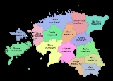
Counties of Estonia
Encyclopedia
A county
is an administrative subdivision of Estonia
.
Estonia is divided into 15 counties. The government (Estonian: maavalitsus) of each county is led by a county governor
(Estonian: maavanem), who represents the national government
at the regional level. Governors are appointed by the government for a term of five years.
Each county is further divided into municipalities
which are of two types: urban municipality, or town (linn), and rural municipality, or parish (vald).
 In the first centuries AD political and administrative subdivisions began to emerge in Estonia. Two larger subdivisions appeared: the parish (kihelkond) and the county (maakond). The parish consisted of several villages. Nearly all parishes had at least one fortress. The defense of the local area was directed by the highest official, the parish elder. The county was composed of several parishes, also headed by an elder. By the 13th century the following major counties had developed in Estonia: Saaremaa
(Osilia), Läänemaa (Rotalia or Maritima), Harjumaa
(Harria), Rävala (Revalia), Virumaa
(Vironia), Järvamaa (Jervia), Sakala (Saccala), and Ugandi (Ugaunia). Additionally there were several smaller elderships in central Estonia where danger of war was smaller Vaiga
, Mõhu
, Nurmekund
and Alempois
. The exact number and borders of some elderships are disputed.
The first documented mentioning of Estonian political and administrative subdivisions comes from the Chronicle of Henry of Livonia
, written in the 13th Century during the Northern Crusades
.
The Autonomy of the Estonia counties and parishes ended after conquered and divided between Denmark
, Livonian Order
, Bishopric of Dorpat
and Bishopric of Ösel-Wiek
. The name of Rävala became Reval, replacing the name of an Estonian town Lindanisse, later Tallinn
. Ugandi, Sakala and the smaller elderships disappeared from common usage.
In the 1580s, after the Livonian war
as Sweden
had conquered Northern Estonia, Harju, Järva, Lääne and Viru counties were officially formed there. Southern Estonia, which belonged to Poland
1582-1625, was divided into voivodships of Pärnu and Tartu; the island of Saaremaa belonged to Denmark
until 1645. They all became counties as they went under Swedish rule.
This administrative system mostly remained as Estonia went under Russian rule as a result of the Northern War
. In 1793 were formed Võru County
in the south of Tartumaa, Viljandi County
between Tartu and Pärnu counties, and Paldiski
County in the west of Harjumaa. In 1796 Paldiski County was joined with Harjumaa again. Until 1888 Võrumaa and Viljandimaa were not completely independent from Tartumaa and Pärnumaa respectively.
Several changes were made to the borders of countis after Estonia became independent, most notably the formation of Valga County
(from parts of Võru, Tartu and Viljandi counties) and Petseri County
(area acquired from Russia with the 1920 Tartu peace treaty).
During the Soviet rule, Petseri County once again became a part of Russia in 1945. Hiiumaa seceded from Läänemaa in 1946, Jõgevamaa from Tartumaa in 1949 and Jõhvimaa (modern Ida-Virumaa) from Virumaa in 1949. Counties were completely dissolved in 1950 as Estonian SSR was divided into regions (rajoonid) and (until 1953) oblast
s. Until the 1960s the borders of regions changed often until 15 of them were left. Out of them, Põlva
and Rapla
regions became separate, while the others were roughly corresponding to the pre-1950 counties.
Counties were re-established in 1 January 1990 in the borders of the Soviet-era regions. Due to the numerous differences between the current and historical (pre-1940) layouts, the historical borders are still used in ethnology, representing cultural and linguistical differences better.
County
A county is a jurisdiction of local government in certain modern nations. Historically in mainland Europe, the original French term, comté, and its equivalents in other languages denoted a jurisdiction under the sovereignty of a count A county is a jurisdiction of local government in certain...
is an administrative subdivision of Estonia
Estonia
Estonia , officially the Republic of Estonia , is a state in the Baltic region of Northern Europe. It is bordered to the north by the Gulf of Finland, to the west by the Baltic Sea, to the south by Latvia , and to the east by Lake Peipsi and the Russian Federation . Across the Baltic Sea lies...
.
Estonia is divided into 15 counties. The government (Estonian: maavalitsus) of each county is led by a county governor
Governor
A governor is a governing official, usually the executive of a non-sovereign level of government, ranking under the head of state...
(Estonian: maavanem), who represents the national government
Government
Government refers to the legislators, administrators, and arbitrators in the administrative bureaucracy who control a state at a given time, and to the system of government by which they are organized...
at the regional level. Governors are appointed by the government for a term of five years.
Each county is further divided into municipalities
Municipalities of Estonia
A Municipality is the smallest administrative subdivision of Estonia. Each municipality is a unit of self-government with its representative and executive bodies. The municipalities in Estonia cover the entire territory of the country....
which are of two types: urban municipality, or town (linn), and rural municipality, or parish (vald).
List of counties
Population figures represent 1 January 2009.| Counties | |Area Area Area is a quantity that expresses the extent of a two-dimensional surface or shape in the plane. Area can be understood as the amount of material with a given thickness that would be necessary to fashion a model of the shape, or the amount of paint necessary to cover the surface with a single coat... | Population Population A population is all the organisms that both belong to the same group or species and live in the same geographical area. The area that is used to define a sexual population is such that inter-breeding is possible between any pair within the area and more probable than cross-breeding with individuals... |
|
|---|---|---|---|
| Harjumaa Harju County Harju County , or Harjumaa , nowadays one of 15 counties of Estonia. It is situated in northern Estonia, on the south coast of the Gulf of Finland, and borders Lääne-Viru County to the east, Järva County to the south-east, Rapla County to the south, and Lääne County to the south-west.528,468 people... |
Tallinn Tallinn Tallinn is the capital and largest city of Estonia. It occupies an area of with a population of 414,940. It is situated on the northern coast of the country, on the banks of the Gulf of Finland, south of Helsinki, east of Stockholm and west of Saint Petersburg. Tallinn's Old Town is in the list... |
4,333 km² | 524,938 |
| Hiiumaa | Kärdla Kärdla Kärdla is the largest town on the Estonian island of Hiiumaa and the capital of Hiiu County.-Geography:Kärdla is located on the north-eastern coast of Hiiumaa, by the Gulf of Tareste . Southeast of the town is the Kärdla meteorite crater, which is 455 million years old.Several small rivers flow... |
989 km² | 10,097 |
| Ida-Virumaa Ida-Viru County Ida-Viru County , or Ida-Virumaa, is one of 15 counties of Estonia. It is the most north-eastern part of the country. The county contains large deposits of oil shale - the main mineral mined in Estonia. As oil shale is used in thermal power plants, the earth in Ida-Viru literally holds the largest... |
Jõhvi Jõhvi Jõhvi is a town in north-eastern Estonia, and the capital of Ida-Viru County. The town is also an administrative centre of Jõhvi Parish. It is situated 50 km from the Russian border.... |
3,364 km² | 169,688 |
| Jõgevamaa Jõgeva County Jõgeva County , or Jõgevamaa, is one of 15 counties of Estonia. It is situated in eastern part of the country and borders Ida-Viru County to the north-east, Lake Peipus to the east, Tartu County to the south, Viljandi County to the south-west, Järva County to the north-west and Lääne-Viru County to... |
Jõgeva Jõgeva Jõgeva is a small town in Estonia with a population of around 6000 people. It is the administrative centre of Jõgeva County.It is known as the coldest place in Estonia with the lowest temperature of... |
2,604 km² | 36,780 |
| Järvamaa Järva County Järva County , or Järvamaa , is one of 15 counties of Estonia. It is situated in central part of the country and borders Lääne-Viru County to the east, Jõgeva County to the south-east, Viljandi County to the south, Pärnu County to the south-west, Rapla County to the west, and Harju County to the... |
Paide Paide Paide is the capital of Järva County, Estonia.A castle built by the Livonian Brothers of the Sword is located here. The town was formally founded 30 September 1291 by Halt, master of the Livonian Order.... |
2,623 km² | 36,130 |
| Läänemaa Lääne County Lääne County , or Läänemaa , is one of 15 counties of Estonia. It is located in western Estonia and borders Baltic Sea to the north, Harju County to the north-east, Rapla County to the east, Pärnu County to the south, and the island counties of Saare and Hiiu to the west... |
Haapsalu Haapsalu Haapsalu is a seaside resort town located on the west coast of Estonia. It's the administrative centre of Lääne County and has a population of 11,618 .... |
2,383 km² | 27,477 |
| Lääne-Virumaa | Rakvere Rakvere Rakvere is a town in northern Estonia and the county seat of Lääne-Viru County, 20 km south of the Gulf of Finland.-History:The earliest signs of human settlement dating back to the 3rd-5th centuries AD have been found on the present theatre hill. Probably to protect that settlement, a wooden... |
3,627 km² | 67,151 |
| Põlvamaa Põlva County Põlva County , or Põlvamaa, is one of 15 counties of Estonia. It is situated in south-eastern part of the country and borders Tartu, Valga and Võru counties. The county also shares a common border with Russia... |
Põlva Põlva Põlva , is the capital of Põlva County , one of 15 counties of Estonia. The county is situated in south-eastern part of the country and borders Tartu, Valga and Võru counties... |
2,165 km² | 31,002 |
| Pärnumaa Pärnu County Pärnu County , or Pärnumaa , is one of 15 counties of Estonia. It is situated in south-western part of the country, on the coast of Gulf of Riga, and borders Lääne and Rapla counties to the north, Järva and Viljandi counties to the east, and Latvia to the south... |
Pärnu Pärnu Pärnu is a city in southwestern Estonia on the coast of Pärnu Bay, an inlet of the Gulf of Riga in the Baltic Sea. It is a popular summer vacation resort with many hotels, restaurants, and large beaches. The Pärnu River flows through the city and drains into the Gulf of Riga... |
4,807 km² | 88,466 |
| Raplamaa Rapla County Rapla County , or Raplamaa, is one of 15 counties of Estonia. It is situated in western part of the country and borders Järva County to the east, Pärnu County to the south, Lääne County to the west, and Harju County to the north... |
Rapla Rapla Rapla is a town in central Estonia, the administrative centre of Rapla County and Rapla Parish. It has a population of 5,618 .-External links:*... |
2,980 km² | 36,678 |
| Saaremaa Saare County Saare County , or Saaremaa, is one of 15 counties of Estonia. It consists of Saaremaa , the largest island of Estonia, and several smaller islands near it. The county borders Lääne County to the east and Hiiu County to the north... |
Kuressaare Kuressaare Kuressaare is a town and a municipality on Saaremaa island in Estonia. It is the capital of Saare County. The current population is about 14,706 Kuressaare is a town and a municipality on Saaremaa island in Estonia. It is the capital of Saare County. The current population is about 14,706... |
2,673 km² | 34,723 |
| Tartumaa Tartu County Tartu County , or Tartumaa , is one of 15 counties of Estonia.It is located in eastern Estonia bordering Põlva County, Valga County, Viljandi County and Jõgeva County.... |
Tartu Tartu Tartu is the second largest city of Estonia. In contrast to Estonia's political and financial capital Tallinn, Tartu is often considered the intellectual and cultural hub, especially since it is home to Estonia's oldest and most renowned university. Situated 186 km southeast of Tallinn, the... |
2,993 km² | 149,605 |
| Valgamaa Valga County Valga County , or Valgamaa, is one of 15 counties of Estonia. Its capital is Valga, which is located on the Estonian-Latvian border. It is situated in southern part of the country and borders Põlva County and Võru County to the east, Latvia to the south and to the west, Viljandi County and Tartu... |
Valga | 2,044 km² | 34,135 |
| Viljandimaa Viljandi County Viljandi County , is one of 15 counties of Estonia. It is located in southern Estonia bordering Pärnu, Järva, Jõgeva, Tartu and Valga counties. 55,657 people live in Viljandi County – constituting 4.2% of the total population in Estonia .... |
Viljandi Viljandi Viljandi is a town and municipality in southern Estonia with a population of 19,150 . It is the capital of Viljandi County. The town was first mentioned in 1283, upon being granted its town charter by Wilhelm von Endorpe.... |
3,422 km² | 55,657 |
| Võrumaa Võru County Võrumaa or Võru maakond officially, is a county in Southern Estonia. It is bordered to the north by the Põlva County and the Lake Pihkva; to the west by Valga County; to the south by Latvia; and to the east by the Russian Federation.... |
Võru Võru Võru is a town and a municipality in south-eastern Estonia. It is the capital of Võru County and the centre of Võru Parish.-History:Võru was founded on 21 August 1784, according to the wish of the Empress Catherine II of Russia, by the order of Riga Governor general count George Browne, on the... |
2,305 km² | 37,888 |
History
Saare County
Saare County , or Saaremaa, is one of 15 counties of Estonia. It consists of Saaremaa , the largest island of Estonia, and several smaller islands near it. The county borders Lääne County to the east and Hiiu County to the north...
(Osilia), Läänemaa (Rotalia or Maritima), Harjumaa
Harjumaa
Harjumaa, , was an ancient Estonian county. It corresponded roughly to the present territory of Rapla County.- See also :*Danish Estonia*Harju County*Rapla County*History of Estonia*Livonian Crusade*Rulers of Estonia...
(Harria), Rävala (Revalia), Virumaa
Virumaa
Virumaa is a former independent county in Ancient Estonia. Now it is divided into Ida-Viru County or Eastern Vironia and Lääne-Viru County or Western Vironia...
(Vironia), Järvamaa (Jervia), Sakala (Saccala), and Ugandi (Ugaunia). Additionally there were several smaller elderships in central Estonia where danger of war was smaller Vaiga
Vaiga
Vaiga was a small landlocked ancient Estonian county in the eastern part of the territory of Estonia.- External links :***...
, Mõhu
Mõhu
Mõhu was a small landlocked ancient Estonian county in the central part of the territory of Estonia.- External links :***...
, Nurmekund
Nurmekund
Nurmekund was a small independent country on the north coast of Lake Võrtsjärv in Central Estonia, bordered by Sakala, Alempois, Järvamaa, Mõhu, and Ugandi...
and Alempois
Alempois
Alempois was a small independent landlocked country in ancient Estonia, bordered by Harjumaa, Järvamaa, Nurmekund, Sakala, and Läänemaa. Alempois had an area of approximately 400 hides.- See also :*Livonian Crusade*Monastic state of the Teutonic Knights...
. The exact number and borders of some elderships are disputed.
The first documented mentioning of Estonian political and administrative subdivisions comes from the Chronicle of Henry of Livonia
Chronicle of Henry of Livonia
The Livonian Chronicle of Henry is a document describing historic events in Livonia and surrounding areas from 1180 to 1227. Apart from the few references in the Primary Chronicle compiled in Kievan Rus' in the twelfth century, it is the oldest known written document about the history of these...
, written in the 13th Century during the Northern Crusades
Northern Crusades
The Northern Crusades or Baltic Crusades were crusades undertaken by the Christian kings of Denmark and Sweden, the German Livonian and Teutonic military orders, and their allies against the pagan peoples of Northern Europe around the southern and eastern shores of the Baltic Sea...
.
The Autonomy of the Estonia counties and parishes ended after conquered and divided between Denmark
Denmark
Denmark is a Scandinavian country in Northern Europe. The countries of Denmark and Greenland, as well as the Faroe Islands, constitute the Kingdom of Denmark . It is the southernmost of the Nordic countries, southwest of Sweden and south of Norway, and bordered to the south by Germany. Denmark...
, Livonian Order
Livonian Order
The Livonian Order was an autonomous Livonian branch of the Teutonic Order and a member of the Livonian Confederation from 1435–1561. After being defeated by Samogitians in the 1236 Battle of Schaulen , the remnants of the Livonian Brothers of the Sword were incorporated into the Teutonic Knights...
, Bishopric of Dorpat
Bishopric of Dorpat
The Bishopric of Dorpat was a medieval principality and a catholic diocese which existed from 1224 to 1558, generally encompassing what are now Tartu, Põlva, Võru and Jõgeva counties in Estonia. The Bishopric was part of Livonian Confederation...
and Bishopric of Ösel-Wiek
Bishopric of Ösel-Wiek
The Bishopric of Ösel–Wiek was a semi-independent Roman Catholic prince-bishopric in what is now Saare, Hiiu and Lääne counties of Estonia.The bishopric was created as a state of Holy Roman Empire on 1 October 1228, by Henry, King of the Romans...
. The name of Rävala became Reval, replacing the name of an Estonian town Lindanisse, later Tallinn
Tallinn
Tallinn is the capital and largest city of Estonia. It occupies an area of with a population of 414,940. It is situated on the northern coast of the country, on the banks of the Gulf of Finland, south of Helsinki, east of Stockholm and west of Saint Petersburg. Tallinn's Old Town is in the list...
. Ugandi, Sakala and the smaller elderships disappeared from common usage.
In the 1580s, after the Livonian war
Livonian War
The Livonian War was fought for control of Old Livonia in the territory of present-day Estonia and Latvia when the Tsardom of Russia faced a varying coalition of Denmark–Norway, the Kingdom of Sweden, the Union of the Grand Duchy of Lithuania and the Kingdom of Poland.During the period 1558–1578,...
as Sweden
Sweden
Sweden , officially the Kingdom of Sweden , is a Nordic country on the Scandinavian Peninsula in Northern Europe. Sweden borders with Norway and Finland and is connected to Denmark by a bridge-tunnel across the Öresund....
had conquered Northern Estonia, Harju, Järva, Lääne and Viru counties were officially formed there. Southern Estonia, which belonged to Poland
Poland
Poland , officially the Republic of Poland , is a country in Central Europe bordered by Germany to the west; the Czech Republic and Slovakia to the south; Ukraine, Belarus and Lithuania to the east; and the Baltic Sea and Kaliningrad Oblast, a Russian exclave, to the north...
1582-1625, was divided into voivodships of Pärnu and Tartu; the island of Saaremaa belonged to Denmark
Denmark
Denmark is a Scandinavian country in Northern Europe. The countries of Denmark and Greenland, as well as the Faroe Islands, constitute the Kingdom of Denmark . It is the southernmost of the Nordic countries, southwest of Sweden and south of Norway, and bordered to the south by Germany. Denmark...
until 1645. They all became counties as they went under Swedish rule.
This administrative system mostly remained as Estonia went under Russian rule as a result of the Northern War
Northern War
Northern War may refer to:*Northern Wars *Great Northern War *Flagstaff War *War in the North...
. In 1793 were formed Võru County
Võru County
Võrumaa or Võru maakond officially, is a county in Southern Estonia. It is bordered to the north by the Põlva County and the Lake Pihkva; to the west by Valga County; to the south by Latvia; and to the east by the Russian Federation....
in the south of Tartumaa, Viljandi County
Viljandi County
Viljandi County , is one of 15 counties of Estonia. It is located in southern Estonia bordering Pärnu, Järva, Jõgeva, Tartu and Valga counties. 55,657 people live in Viljandi County – constituting 4.2% of the total population in Estonia ....
between Tartu and Pärnu counties, and Paldiski
Paldiski
Paldiski is a town and Baltic Sea port situated on the Pakri peninsula of north-western Estonia. Originally a Swedish settlement known as Rågervik, it became a Russian naval base in the 18th century. The Russians renamed it Балтийский Порт Paldiski is a town and Baltic Sea port situated on the...
County in the west of Harjumaa. In 1796 Paldiski County was joined with Harjumaa again. Until 1888 Võrumaa and Viljandimaa were not completely independent from Tartumaa and Pärnumaa respectively.
Several changes were made to the borders of countis after Estonia became independent, most notably the formation of Valga County
Valga County
Valga County , or Valgamaa, is one of 15 counties of Estonia. Its capital is Valga, which is located on the Estonian-Latvian border. It is situated in southern part of the country and borders Põlva County and Võru County to the east, Latvia to the south and to the west, Viljandi County and Tartu...
(from parts of Võru, Tartu and Viljandi counties) and Petseri County
Petseri County
Petseri County was a county of Estonia established in 1920. Since 1944, however, most of the county had been administered as Pechorsky District of Pskov Oblast, first by the Russian SFSR and then, from 1991, by Russia.-History:...
(area acquired from Russia with the 1920 Tartu peace treaty).
During the Soviet rule, Petseri County once again became a part of Russia in 1945. Hiiumaa seceded from Läänemaa in 1946, Jõgevamaa from Tartumaa in 1949 and Jõhvimaa (modern Ida-Virumaa) from Virumaa in 1949. Counties were completely dissolved in 1950 as Estonian SSR was divided into regions (rajoonid) and (until 1953) oblast
Oblast
Oblast is a type of administrative division in Slavic countries, including some countries of the former Soviet Union. The word "oblast" is a loanword in English, but it is nevertheless often translated as "area", "zone", "province", or "region"...
s. Until the 1960s the borders of regions changed often until 15 of them were left. Out of them, Põlva
Põlva County
Põlva County , or Põlvamaa, is one of 15 counties of Estonia. It is situated in south-eastern part of the country and borders Tartu, Valga and Võru counties. The county also shares a common border with Russia...
and Rapla
Rapla County
Rapla County , or Raplamaa, is one of 15 counties of Estonia. It is situated in western part of the country and borders Järva County to the east, Pärnu County to the south, Lääne County to the west, and Harju County to the north...
regions became separate, while the others were roughly corresponding to the pre-1950 counties.
Counties were re-established in 1 January 1990 in the borders of the Soviet-era regions. Due to the numerous differences between the current and historical (pre-1940) layouts, the historical borders are still used in ethnology, representing cultural and linguistical differences better.
See also
- Ranked list of Estonian countiesRanked list of Estonian counties-By population:as of 1 January 2008-By area:-By density:...
- Flags of Estonian CountiesFlags of Estonian CountiesThe flags of the 15 counties of Estonia are all white and green, with the coat of arms of the respective county on the white part. This design was first established in 1938...
- Coats of arms of Estonian Counties
- ISO 3166-2:EEISO 3166-2:EEISO 3166-2:EE is the entry for Estonia in ISO 3166-2, part of the ISO 3166 standard published by the International Organization for Standardization , which defines codes for the names of the principal subdivisions of all countries coded in ISO 3166-1.Currently for Estonia, ISO 3166-2 codes are...
- Municipalities of EstoniaMunicipalities of EstoniaA Municipality is the smallest administrative subdivision of Estonia. Each municipality is a unit of self-government with its representative and executive bodies. The municipalities in Estonia cover the entire territory of the country....
External links
- Local Government Reform Estonian Institute publication