

Counties (Detached Parts) Act 1844
Encyclopedia
The Counties Act 1844 (7 & 8 Vict
. c. 61), which came into effect on 20 October 1844, was an Act of Parliament of the United Kingdom
which eliminated many outliers or exclaves of counties
in England and Wales
for civil purposes.
The areas involved had already been reorganised for some purposes: The Reform Act 1832
had abolished the outliers for parliamentary constituencies, the Counties (Detached Parts) Act 1839 allowed Justices of the Peace
to act for exclaves surrounded by their county, and constabularies established under the County Police Act 1839
had jurisdiction over detached parts of other counties.
Section 1 of the Act read in part as follows:
The Act went on to state (s. 2) that the parts transferred would be incorporated in an existing "Hundred
, Wapentake, Ward
, Rape, Lathe, or other like Division by which it is wholly or for the most Part surrounded, or to which it is next adjoining, in the County to which it will thenceforth belong, unless the Justices of the County, [...] shall declare it to be a new or separate Hundred or other like Division [...]."
The Act itself did not list the areas transferred; these had already been detailed in the Parliamentary Boundaries Act 1832
(2 & 3 Will. 4 c. 64).
The Act transferred the detached parts to different counties but not to different parishes. Unless the detached part was an entire parish, this resulted in many cases of a detached part in one county belonging to a parish in a different county. Later legislation, including the Divided Parishes and Poor Law Amendment Act 1882
, eliminated most instances of civil parish
es belonging to two (or more) counties, and by 1901 Stanground in Huntingdonshire
and the Isle of Ely
was the sole remaining example.
, which lost large areas to Northumberland
, as well as a single parish to Yorkshire
. By no means all detached areas were changed: seven counties still had exclaves. Many of these outlying parts changed their administration in the 1890s following the passing of the Local Government Act 1894
. Large detached blocks of Warwickshire
and Worcestershire
interspersed with Gloucestershire
remained until 1931, while Flintshire
retained two exclaves until 1974 — a large one (the Maelor
Saesneg area) east of Wrexham
in Denbighshire and a single parish exclave (Marford & Hoseley) north of Wrexham.
Bedfordshire
Transferred to other counties:
Transferred from other counties:
Berkshire
Transferred to other counties:
Transferred from other counties:
Buckinghamshire
Transferred to other counties:
Transferred from other counties:
Cornwall
Transferred to other counties:
Transferred from other counties:
Denbighshire
Transferred to other counties:
Derbyshire
Transferred to other counties:
Also:
Devon
Transferred to other counties:
Transferred from other counties:
Dorset
Transferred to other counties:
Transferred from other counties:
County Durham
Transferred to other counties:
Gloucestershire
Transferred to other counties:
Transferred from other counties:
Hampshire
Transferred to other counties:
Herefordshire
Transferred to other counties:
Transferred from other counties:
Hertfordshire
Transferred to other counties:
Transferred from other counties:
Huntingdonshire
Transferred from other counties:
Monmouthshire
Transferred to other counties:
Transferred from other counties:
Montgomeryshire
Transferred from other counties:
Northamptonshire
Transferred to other counties:
Transferred from other counties:
Northumberland
Transferred from other counties:
Oxfordshire
Transferred to other counties:
Transferred from other counties:
Shropshire
 Transferred to other counties:
Transferred from other counties:
Somerset
Transferred to other counties:
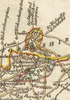
Staffordshire
Transferred to other counties:
Transferred from other counties:
Sussex
Transferred from other counties:
Warwickshire
Transferred to other counties:
Transferred from other counties:
Wiltshire
Transferred to other counties:
Transferred from other counties:
Worcestershire
Transferred to other counties:
Transferred from other counties:
Yorkshire
Transferred from other counties:
Victoria of the United Kingdom
Victoria was the monarch of the United Kingdom of Great Britain and Ireland from 20 June 1837 until her death. From 1 May 1876, she used the additional title of Empress of India....
. c. 61), which came into effect on 20 October 1844, was an Act of Parliament of the United Kingdom
Parliament of the United Kingdom
The Parliament of the United Kingdom of Great Britain and Northern Ireland is the supreme legislative body in the United Kingdom, British Crown dependencies and British overseas territories, located in London...
which eliminated many outliers or exclaves of counties
County
A county is a jurisdiction of local government in certain modern nations. Historically in mainland Europe, the original French term, comté, and its equivalents in other languages denoted a jurisdiction under the sovereignty of a count A county is a jurisdiction of local government in certain...
in England and Wales
England and Wales
England and Wales is a jurisdiction within the United Kingdom. It consists of England and Wales, two of the four countries of the United Kingdom...
for civil purposes.
The areas involved had already been reorganised for some purposes: The Reform Act 1832
Reform Act 1832
The Representation of the People Act 1832 was an Act of Parliament that introduced wide-ranging changes to the electoral system of England and Wales...
had abolished the outliers for parliamentary constituencies, the Counties (Detached Parts) Act 1839 allowed Justices of the Peace
Justice of the Peace
A justice of the peace is a puisne judicial officer elected or appointed by means of a commission to keep the peace. Depending on the jurisdiction, they might dispense summary justice or merely deal with local administrative applications in common law jurisdictions...
to act for exclaves surrounded by their county, and constabularies established under the County Police Act 1839
County Police Act 1839
The County Police Act 1839 was an Act of Parliament passed by the Parliament of the United Kingdom. The act enabled Justices of the Peace in England and Wales to establish police forces in their counties...
had jurisdiction over detached parts of other counties.
Section 1 of the Act read in part as follows:
The Act went on to state (s. 2) that the parts transferred would be incorporated in an existing "Hundred
Hundred (division)
A hundred is a geographic division formerly used in England, Wales, Denmark, South Australia, some parts of the United States, Germany , Sweden, Finland and Norway, which historically was used to divide a larger region into smaller administrative divisions...
, Wapentake, Ward
Ward
Ward may refer to:* A Watchman as in Watch and Ward* Ward , someone placed under the protection of a legal guardian* USS Aaron Ward, a series of U.S...
, Rape, Lathe, or other like Division by which it is wholly or for the most Part surrounded, or to which it is next adjoining, in the County to which it will thenceforth belong, unless the Justices of the County, [...] shall declare it to be a new or separate Hundred or other like Division [...]."
The Act itself did not list the areas transferred; these had already been detailed in the Parliamentary Boundaries Act 1832
Parliamentary Boundaries Act 1832
The Parliamentary Boundaries Act 1832 was an Act of the Parliament of the United Kingdom which defined the parliamentary divisions in England and Wales required by the Reform Act 1832....
(2 & 3 Will. 4 c. 64).
The Act transferred the detached parts to different counties but not to different parishes. Unless the detached part was an entire parish, this resulted in many cases of a detached part in one county belonging to a parish in a different county. Later legislation, including the Divided Parishes and Poor Law Amendment Act 1882
Divided Parishes and Poor Law Amendment Act 1882
Divided Parishes and Poor Law Amendment Act 1882 was an Act of Parliament in Britain which gave the Local Government Board increased powers relating to dissolving and creating Poor Law Unions. It followed the Divided Parishes and Poor Law Amendment Act 1876 ....
, eliminated most instances of civil parish
Civil parish
In England, a civil parish is a territorial designation and, where they are found, the lowest tier of local government below districts and counties...
es belonging to two (or more) counties, and by 1901 Stanground in Huntingdonshire
Huntingdonshire
Huntingdonshire is a local government district of Cambridgeshire, covering the area around Huntingdon. Traditionally it is a county in its own right...
and the Isle of Ely
Isle of Ely
The Isle of Ely is a historic region around the city of Ely now in Cambridgeshire, England but previously a county in its own right.-Etymology:...
was the sole remaining example.
Areas transferred
The Act affected twenty-seven counties. The largest changes were to County DurhamCounty Durham
County Durham is a ceremonial county and unitary district in north east England. The county town is Durham. The largest settlement in the ceremonial county is the town of Darlington...
, which lost large areas to Northumberland
Northumberland
Northumberland is the northernmost ceremonial county and a unitary district in North East England. For Eurostat purposes Northumberland is a NUTS 3 region and is one of three boroughs or unitary districts that comprise the "Northumberland and Tyne and Wear" NUTS 2 region...
, as well as a single parish to Yorkshire
Yorkshire
Yorkshire is a historic county of northern England and the largest in the United Kingdom. Because of its great size in comparison to other English counties, functions have been increasingly undertaken over time by its subdivisions, which have also been subject to periodic reform...
. By no means all detached areas were changed: seven counties still had exclaves. Many of these outlying parts changed their administration in the 1890s following the passing of the Local Government Act 1894
Local Government Act 1894
The Local Government Act 1894 was an Act of the Parliament of the United Kingdom that reformed local government in England and Wales outside the County of London. The Act followed the reforms carried out at county level under the Local Government Act 1888...
. Large detached blocks of Warwickshire
Warwickshire
Warwickshire is a landlocked non-metropolitan county in the West Midlands region of England. The county town is Warwick, although the largest town is Nuneaton. The county is famous for being the birthplace of William Shakespeare...
and Worcestershire
Worcestershire
Worcestershire is a non-metropolitan county, established in antiquity, located in the West Midlands region of England. For Eurostat purposes it is a NUTS 3 region and is one of three counties that comprise the "Herefordshire, Worcestershire and Warwickshire" NUTS 2 region...
interspersed with Gloucestershire
Gloucestershire
Gloucestershire is a county in South West England. The county comprises part of the Cotswold Hills, part of the flat fertile valley of the River Severn, and the entire Forest of Dean....
remained until 1931, while Flintshire
Flintshire (historic)
Flintshire , also known as the County of Flint, is one of thirteen historic counties, a vice-county and a former administrative county, which mostly lies on the north east coast of Wales....
retained two exclaves until 1974 — a large one (the Maelor
Maelor
Maelor is a border area of north-east Wales. It originated as a Cantref of the Kingdom of Powys, focused on Bangor-on-Dee.-History:The Maelor was first divided from the rest of Wales by the construction of Offa's Dyke in the eighth century, but was reclaimed for Wales during the reign of Stephen...
Saesneg area) east of Wrexham
Wrexham
Wrexham is a town in Wales. It is the administrative centre of the wider Wrexham County Borough, and the largest town in North Wales, located in the east of the region. It is situated between the Welsh mountains and the lower Dee Valley close to the border with Cheshire, England...
in Denbighshire and a single parish exclave (Marford & Hoseley) north of Wrexham.
BedfordshireBedfordshireBedfordshire is a ceremonial county of historic origin in England that forms part of the East of England region.It borders Cambridgeshire to the north-east, Northamptonshire to the north, Buckinghamshire to the west and Hertfordshire to the south-east....
Transferred to other counties:
- The part of the hamlet of TetworthTetworthTetworth – in Huntingdonshire , England – is a small village near Waresley south of St Neots.Tetworth is in the ward of Gransden and the Offords in the District of Huntingdonshire.-History:...
(in the parish of EvertonEverton, BedfordshireEverton is a small village and civil parish located in north Bedfordshire, England. Everton has no shop but is home to a pub, local church, and a lower school...
) in Bedfordshire transferred to HuntingdonshireHuntingdonshireHuntingdonshire is a local government district of Cambridgeshire, covering the area around Huntingdon. Traditionally it is a county in its own right... - The part of the parish of IcklefordIcklefordIckleford is a large village situated on the northern outskirts of Hitchin in North Hertfordshire in England. It lies on the west bank of the River Hiz and to the east of the main A600 road...
in Bedfordshire transferred to HertfordshireHertfordshireHertfordshire is a ceremonial and non-metropolitan county in the East region of England. The county town is Hertford.The county is one of the Home Counties and lies inland, bordered by Greater London , Buckinghamshire , Bedfordshire , Cambridgeshire and...
Transferred from other counties:
- The part of the parish of MeppershallMeppershallMeppershall is a hilltop village in Bedfordshire near Shefford, Campton, Shillington, Stondon and surrounded by farmland. The Village and the Manor House are mentioned in the Domesday book in 1086....
in HertfordshireHertfordshireHertfordshire is a ceremonial and non-metropolitan county in the East region of England. The county town is Hertford.The county is one of the Home Counties and lies inland, bordered by Greater London , Buckinghamshire , Bedfordshire , Cambridgeshire and... - The part of the parish of StudhamStudhamStudham is a village and civil parish in the county of Bedfordshire. It has a population of 1,125. The parish bounds to the south the Buckinghamshire border, and to the east is the Hertfordshire border. The village lies in the wooded south facing rolls of the Chiltern Hills...
in HertfordshireHertfordshireHertfordshire is a ceremonial and non-metropolitan county in the East region of England. The county town is Hertford.The county is one of the Home Counties and lies inland, bordered by Greater London , Buckinghamshire , Bedfordshire , Cambridgeshire and... - The part of the parish of FarndishFarndishFarndish is a very small and rural village in northwest Bedfordshire, located about 500 metres east of the county border with Northamptonshire which is also the postal county. The village is near the Northamptonshire villages of Irchester and Wollaston and the Bedfordshire village of Wymington...
in NorthamptonshireNorthamptonshireNorthamptonshire is a landlocked county in the English East Midlands, with a population of 629,676 as at the 2001 census. It has boundaries with the ceremonial counties of Warwickshire to the west, Leicestershire and Rutland to the north, Cambridgeshire to the east, Bedfordshire to the south-east,...
BerkshireBerkshireBerkshire is a historic county in the South of England. It is also often referred to as the Royal County of Berkshire because of the presence of the royal residence of Windsor Castle in the county; this usage, which dates to the 19th century at least, was recognised by the Queen in 1957, and...
Transferred to other counties:
- The part of the parish of Great Barrington in Berkshire transferred to GloucestershireGloucestershireGloucestershire is a county in South West England. The county comprises part of the Cotswold Hills, part of the flat fertile valley of the River Severn, and the entire Forest of Dean....
- The tithing and chapelry of Little FaringdonLittle FaringdonLittle Faringdon is a village and civil parish in West Oxfordshire, about north of Lechlade in neighbouring Gloucestershire.-History:In the late Anglo-Saxon period Little Faringdon was part of a large estate that included Faringdon , from which it took its name...
(in the parish of LangfordLangford, OxfordshireLangford is a village and civil parish in West Oxfordshire, about northeast of Lechlade in neighbouring Gloucestershire.-Manor:The Domesday Book of 1086 records that a Saxon, Ælfsige of Faringdon, held the manor. In the reign of Edward the Confessor Ælfsige had been a minor landholder, holding two...
) transferred to OxfordshireOxfordshireOxfordshire is a county in the South East region of England, bordering on Warwickshire and Northamptonshire , Buckinghamshire , Berkshire , Wiltshire and Gloucestershire .... - The part of the parish of ShiltonShilton, OxfordshireShilton is a village and civil parish about northwest of Carterton, Oxfordshire.-History:Shilton was historically part of the manor of Faringdon, and most of the parish was an exclave of Berkshire until the Counties Act 1844 joined it to Oxfordshire.The earliest parts of the Church of England...
in Berkshire transferred to OxfordshireOxfordshireOxfordshire is a county in the South East region of England, bordering on Warwickshire and Northamptonshire , Buckinghamshire , Berkshire , Wiltshire and Gloucestershire .... - The tithing of Oxenwood (in the parish of ShalbourneShalbourneShalbourne is a civil parish in the English county of Wiltshire. Besides a village of the same name, the parish includes a number of widely spaced small settlements, including Bagshot and Stype, to the north, and Rivar and Oxenwood to the south...
) in Berkshire transferred to WiltshireWiltshireWiltshire is a ceremonial county in South West England. It is landlocked and borders the counties of Dorset, Somerset, Hampshire, Gloucestershire, Oxfordshire and Berkshire. It contains the unitary authority of Swindon and covers... - The part of the parish of IngleshamIngleshamInglesham is a village and civil parish in the borough of Swindon, Wiltshire. The village is just off the A361 road about south-west of Lechlade in Gloucestershire...
in Berkshire transferred to WiltshireWiltshireWiltshire is a ceremonial county in South West England. It is landlocked and borders the counties of Dorset, Somerset, Hampshire, Gloucestershire, Oxfordshire and Berkshire. It contains the unitary authority of Swindon and covers...
Transferred from other counties:
- The part of the parochial chapelry of HurstHurst, BerkshireHurst is a village in the civil parish of St Nicholas Hurst in the English county of Berkshire.-Geography:The parish of St Nicholas Hurst is situated at , north of Wokingham and south of Twyford in the county of Berkshire...
(in the parish of Sonning) in WiltshireWiltshireWiltshire is a ceremonial county in South West England. It is landlocked and borders the counties of Dorset, Somerset, Hampshire, Gloucestershire, Oxfordshire and Berkshire. It contains the unitary authority of Swindon and covers... - The part of the parish of ShinfieldShinfieldShinfield is a village and civil parish in the English county of Berkshire, just south of Reading. It contains and is administered by the unitary authority of Wokingham District.-Geography:...
in WiltshireWiltshireWiltshire is a ceremonial county in South West England. It is landlocked and borders the counties of Dorset, Somerset, Hampshire, Gloucestershire, Oxfordshire and Berkshire. It contains the unitary authority of Swindon and covers... - The part of the parish of WokinghamWokinghamWokingham is a market town and civil parish in Berkshire in South East England about west of central London. It is about east-southeast of Reading and west of Bracknell. It spans an area of and, according to the 2001 census, has a population of 30,403...
in WiltshireWiltshireWiltshire is a ceremonial county in South West England. It is landlocked and borders the counties of Dorset, Somerset, Hampshire, Gloucestershire, Oxfordshire and Berkshire. It contains the unitary authority of Swindon and covers...
BuckinghamshireBuckinghamshireBuckinghamshire is a ceremonial and non-metropolitan home county in South East England. The county town is Aylesbury, the largest town in the ceremonial county is Milton Keynes and largest town in the non-metropolitan county is High Wycombe....
Transferred to other counties:
- The hamlet of StudleyStudleyStudley is a large village and civil parish in the Stratford-on-Avon district of Warwickshire, England. Situated on the western edge of Warwickshire near the border with Worcestershire it is southeast of Redditch and northwest of Stratford. The Roman road of Ryknild Street, now the A435, passes...
(in the parish of BeckleyBeckley, OxfordshireBeckley is a village in the civil parish of Beckley and Stowood, overlooking Otmoor to the north. The village is about northeast of the centre of Oxford. It is noted for its towering TV mast.-Archaeology:...
) in Buckinghamshire transferred to OxfordshireOxfordshireOxfordshire is a county in the South East region of England, bordering on Warwickshire and Northamptonshire , Buckinghamshire , Berkshire , Wiltshire and Gloucestershire .... - The parish of CaversfieldCaversfieldCaversfield is a village and civil parish about north of the centre of Bicester. In 1844 Caversfield became part of Oxfordshire, but until then it was always an exclave of Buckinghamshire entirely surrounded by Oxfordshire.-Early history:...
transferred to OxfordshireOxfordshireOxfordshire is a county in the South East region of England, bordering on Warwickshire and Northamptonshire , Buckinghamshire , Berkshire , Wiltshire and Gloucestershire .... - The part of the extra-parochial place of Luffield AbbeyLuffield AbbeyLuffield Abbey is a village in the very north of Buckinghamshire, England. It is on the border with Northamptonshire, close to Biddlesden. It is one of the few examples in the country where there is an ancient parish with no church at its centre, though since the Victorian era it has been...
in Buckinghamshire transferred to NorthamptonshireNorthamptonshireNorthamptonshire is a landlocked county in the English East Midlands, with a population of 629,676 as at the 2001 census. It has boundaries with the ceremonial counties of Warwickshire to the west, Leicestershire and Rutland to the north, Cambridgeshire to the east, Bedfordshire to the south-east,... - The part of the chapelry of Stratton AudleyStratton AudleyStratton Audley is a village and civil parish northeast of Bicester in Oxfordshire, England.-Manor:The Domesday Book of 1086 records that Robert D'Oyly held five hides of land at Stratton. Like many D'Oyly manors, Stratton later became part of the Honour of Wallingford...
(in the parish of BicesterBicesterBicester is a town and civil parish in the Cherwell district of northeastern Oxfordshire in England.This historic market centre is one of the fastest growing towns in Oxfordshire Development has been favoured by its proximity to junction 9 of the M40 motorway linking it to London, Birmingham and...
) in Buckinghamshire transferred to OxfordshireOxfordshireOxfordshire is a county in the South East region of England, bordering on Warwickshire and Northamptonshire , Buckinghamshire , Berkshire , Wiltshire and Gloucestershire ....
Transferred from other counties:
- The parish of Lillingstone LovellLillingstone LovellLillingstone Lovell is a village and civil parish about miles north of Buckingham in Aylesbury Vale the district of Buckinghamshire. The parish adjoins the Northamptonshire boundary and is about south of Towcester in that county. Lillingstone Lovell is about west of Milton Keynes...
in OxfordshireOxfordshireOxfordshire is a county in the South East region of England, bordering on Warwickshire and Northamptonshire , Buckinghamshire , Berkshire , Wiltshire and Gloucestershire .... - The township of BoycottBoycott, BuckinghamshireBoycott is a hamlet in the parish of Stowe in north Buckinghamshire, England.Boycott was originally an Anglo Saxon settlement. Its name came from Anglo-Saxon Boiacot = either "Boia's Cottage" or "the cottage of the boys or servants"...
(in the parish of StoweStowe, BuckinghamshireStowe is a civil parish and former village about northwest of Buckingham in the Aylesbury Vale district of Buckinghamshire, England. The parish includes the hamlets of Boycott, Dadford and Lamport....
) in OxfordshireOxfordshireOxfordshire is a county in the South East region of England, bordering on Warwickshire and Northamptonshire , Buckinghamshire , Berkshire , Wiltshire and Gloucestershire .... - The chapelry of AckhampsteadAckhampsteadAckhampstead or 'The Moor' was an ancient township in the Chiltern Hills, south of Lane End. Until 1844 it was a detached part of Oxfordshire in the parish of Lewknor, part of a division of the parish known as Lewknor Uphill consisting of three detached parts...
(in the parish of LewknorLewknorLewknor is a village and civil parish south of Thame in Oxfordshire. The civil parish includes the village of Postcombe.-Iron Age and Roman periods:...
) in OxfordshireOxfordshireOxfordshire is a county in the South East region of England, bordering on Warwickshire and Northamptonshire , Buckinghamshire , Berkshire , Wiltshire and Gloucestershire .... - The part of the hamlet of ColeshillColeshill, BuckinghamshireColeshill is a village and civil parish within Chiltern district in Buckinghamshire, England. It is near Amersham and just to the north of Beaconsfield....
(in the parish of AmershamAmershamAmersham is a market town and civil parish within Chiltern district in Buckinghamshire, England, 27 miles north west of London, in the Chiltern Hills. It is part of the London commuter belt....
) in HertfordshireHertfordshireHertfordshire is a ceremonial and non-metropolitan county in the East region of England. The county town is Hertford.The county is one of the Home Counties and lies inland, bordered by Greater London , Buckinghamshire , Bedfordshire , Cambridgeshire and...
CornwallCornwallCornwall is a unitary authority and ceremonial county of England, within the United Kingdom. It is bordered to the north and west by the Celtic Sea, to the south by the English Channel, and to the east by the county of Devon, over the River Tamar. Cornwall has a population of , and covers an area of...
Transferred to other counties:
- The part of the parish of BridgeruleBridgeruleBridgerule is a village and civil parish in Devon, England, a mile from the border with Cornwall. The parish is divided by the River Tamar, which no longer forms the border between Devon and Cornwall there. The river frequently floods the High Street....
in Cornwall transferred to DevonDevonDevon is a large county in southwestern England. The county is sometimes referred to as Devonshire, although the term is rarely used inside the county itself as the county has never been officially "shired", it often indicates a traditional or historical context.The county shares borders with...
Transferred from other counties:
- The part of the parish of St JohnSt John, CornwallSt John is a coastal civil parish and a village in south-east Cornwall, United Kingdom south of Saltash and south-east of Torpoint.-Geography:...
in DevonDevonDevon is a large county in southwestern England. The county is sometimes referred to as Devonshire, although the term is rarely used inside the county itself as the county has never been officially "shired", it often indicates a traditional or historical context.The county shares borders with... - The part of the parish of Maker in DevonDevonDevon is a large county in southwestern England. The county is sometimes referred to as Devonshire, although the term is rarely used inside the county itself as the county has never been officially "shired", it often indicates a traditional or historical context.The county shares borders with...
- The part of the parish of North TamertonNorth TamertonNorth Tamerton is a civil parish and village in east Cornwall, United Kingdom. The village is situated approximately eight miles southeast of Bude and eight miles north of Launceston....
in DevonDevonDevon is a large county in southwestern England. The county is sometimes referred to as Devonshire, although the term is rarely used inside the county itself as the county has never been officially "shired", it often indicates a traditional or historical context.The county shares borders with...
DenbighshireDenbighshire (historic)Historic Denbighshire is one of thirteen traditional counties in Wales, a vice-county and a former administrative county, which covers an area in north east Wales...
Transferred to other counties:
- The township of Carreghova (in the parish of Llanmynech) transferred to MontgomeryshireMontgomeryshireMontgomeryshire, also known as Maldwyn is one of thirteen historic counties and a former administrative county of Wales. Montgomeryshire is still used as a vice-county for wildlife recording...
DerbyshireDerbyshireDerbyshire is a county in the East Midlands of England. A substantial portion of the Peak District National Park lies within Derbyshire. The northern part of Derbyshire overlaps with the Pennines, a famous chain of hills and mountains. The county contains within its boundary of approx...
Transferred to other counties:
- Part of the township of Foston and Scropton (in the parish of ScroptonScroptonFoston and Scropton is a civil parish in the Dove valley in South Derbyshire. It includes the village of Scropton and hamlet of Foston.The Domesday book records that in 1086 Henry de Ferrers held a manor here....
) transferred to StaffordshireStaffordshireStaffordshire is a landlocked county in the West Midlands region of England. For Eurostat purposes, the county is a NUTS 3 region and is one of four counties or unitary districts that comprise the "Shropshire and Staffordshire" NUTS 2 region. Part of the National Forest lies within its borders...
Also:
- The part of the parish of GlossopGlossopGlossop is a market town within the Borough of High Peak in Derbyshire, England. It lies on the Glossop Brook, a tributary of the River Etherow, about east of the city of Manchester, west of the city of Sheffield. Glossop is situated near Derbyshire's county borders with Cheshire, Greater...
on the CheshireCheshireCheshire is a ceremonial county in North West England. Cheshire's county town is the city of Chester, although its largest town is Warrington. Other major towns include Widnes, Congleton, Crewe, Ellesmere Port, Runcorn, Macclesfield, Winsford, Northwich, and Wilmslow...
side of the River EtherowRiver EtherowThe River Etherow is a river in northern England, and a tributary of the River Goyt. Although now passing through South Yorkshire, Derbyshire and Greater Manchester, it historically formed the ancient county boundary between Cheshire and Derbyshire. The upper valley is known as Longdendale...
was declared to be in DerbyshireDerbyshireDerbyshire is a county in the East Midlands of England. A substantial portion of the Peak District National Park lies within Derbyshire. The northern part of Derbyshire overlaps with the Pennines, a famous chain of hills and mountains. The county contains within its boundary of approx...
- its previous status was uncertain
DevonDevonDevon is a large county in southwestern England. The county is sometimes referred to as Devonshire, although the term is rarely used inside the county itself as the county has never been officially "shired", it often indicates a traditional or historical context.The county shares borders with...
Transferred to other counties:
- The part of the parish of Maker in Devon transferred to CornwallCornwallCornwall is a unitary authority and ceremonial county of England, within the United Kingdom. It is bordered to the north and west by the Celtic Sea, to the south by the English Channel, and to the east by the county of Devon, over the River Tamar. Cornwall has a population of , and covers an area of...
- The part of the parish of St JohnSt John, CornwallSt John is a coastal civil parish and a village in south-east Cornwall, United Kingdom south of Saltash and south-east of Torpoint.-Geography:...
in Devon transferred to CornwallCornwallCornwall is a unitary authority and ceremonial county of England, within the United Kingdom. It is bordered to the north and west by the Celtic Sea, to the south by the English Channel, and to the east by the county of Devon, over the River Tamar. Cornwall has a population of , and covers an area of... - The part of the parish of North TamertonNorth TamertonNorth Tamerton is a civil parish and village in east Cornwall, United Kingdom. The village is situated approximately eight miles southeast of Bude and eight miles north of Launceston....
in Devon transferred to CornwallCornwallCornwall is a unitary authority and ceremonial county of England, within the United Kingdom. It is bordered to the north and west by the Celtic Sea, to the south by the English Channel, and to the east by the county of Devon, over the River Tamar. Cornwall has a population of , and covers an area of... - The parish of ThorncombeThorncombeThorncombe is a village and civil parish in west Dorset, England, situated on the borders of Somerset and Devon, five miles south east of Chard. The civil parish has a population of 714 , and 8.4% of dwellings are second homes.-Geography:...
transferred to DorsetDorsetDorset , is a county in South West England on the English Channel coast. The county town is Dorchester which is situated in the south. The Hampshire towns of Bournemouth and Christchurch joined the county with the reorganisation of local government in 1974...
Transferred from other counties:
- The part of the parish of AxminsterAxminsterAxminster is a market town and civil parish on the eastern border of Devon in England. The town is built on a hill overlooking the River Axe which heads towards the English Channel at Axmouth, and is in the East Devon local government district. It has a population of 5,626. The market is still...
in DorsetDorsetDorset , is a county in South West England on the English Channel coast. The county town is Dorchester which is situated in the south. The Hampshire towns of Bournemouth and Christchurch joined the county with the reorganisation of local government in 1974... - The part of the parish of BridgeruleBridgeruleBridgerule is a village and civil parish in Devon, England, a mile from the border with Cornwall. The parish is divided by the River Tamar, which no longer forms the border between Devon and Cornwall there. The river frequently floods the High Street....
in CornwallCornwallCornwall is a unitary authority and ceremonial county of England, within the United Kingdom. It is bordered to the north and west by the Celtic Sea, to the south by the English Channel, and to the east by the county of Devon, over the River Tamar. Cornwall has a population of , and covers an area of... - The parish of StocklandStockland, DevonStockland is a small rural village in Devon, close to the Somerset boundary. Its nearest neighbouring towns Honiton and Axminster, which are 6 miles and 5 miles away respectively. It has a population of around 600...
(including the hamlet of DalwoodDalwoodDalwood is a village and county parish in the East Devon district of the English county of Devon. It is approximately 3 miles away from the nearest town, Axminster, and 5 miles away from Honiton. Dalwood can be accessed by the nearby A35 road. The village is placed within the Blackdown Hills Area...
) in DorsetDorsetDorset , is a county in South West England on the English Channel coast. The county town is Dorchester which is situated in the south. The Hampshire towns of Bournemouth and Christchurch joined the county with the reorganisation of local government in 1974...
DorsetDorsetDorset , is a county in South West England on the English Channel coast. The county town is Dorchester which is situated in the south. The Hampshire towns of Bournemouth and Christchurch joined the county with the reorganisation of local government in 1974...
Transferred to other counties:
- The part of the parish of AxminsterAxminsterAxminster is a market town and civil parish on the eastern border of Devon in England. The town is built on a hill overlooking the River Axe which heads towards the English Channel at Axmouth, and is in the East Devon local government district. It has a population of 5,626. The market is still...
in Dorset transferred to DevonDevonDevon is a large county in southwestern England. The county is sometimes referred to as Devonshire, although the term is rarely used inside the county itself as the county has never been officially "shired", it often indicates a traditional or historical context.The county shares borders with... - The parish of StocklandStockland, DevonStockland is a small rural village in Devon, close to the Somerset boundary. Its nearest neighbouring towns Honiton and Axminster, which are 6 miles and 5 miles away respectively. It has a population of around 600...
(including the hamlet of DalwoodDalwoodDalwood is a village and county parish in the East Devon district of the English county of Devon. It is approximately 3 miles away from the nearest town, Axminster, and 5 miles away from Honiton. Dalwood can be accessed by the nearby A35 road. The village is placed within the Blackdown Hills Area...
) transferred to DevonDevonDevon is a large county in southwestern England. The county is sometimes referred to as Devonshire, although the term is rarely used inside the county itself as the county has never been officially "shired", it often indicates a traditional or historical context.The county shares borders with...
Transferred from other counties:
- The parish of HolwellHolwell, DorsetHolwell is a village in north west Dorset, England, situated in the Blackmore Vale five miles south east of Sherborne. The village has a population of 380 . Until 1844, Holwell was an exclave of Somerset.-External links:*...
in SomersetSomersetThe ceremonial and non-metropolitan county of Somerset in South West England borders Bristol and Gloucestershire to the north, Wiltshire to the east, Dorset to the south-east, and Devon to the south-west. It is partly bounded to the north and west by the Bristol Channel and the estuary of the... - The parish of ThorncombeThorncombeThorncombe is a village and civil parish in west Dorset, England, situated on the borders of Somerset and Devon, five miles south east of Chard. The civil parish has a population of 714 , and 8.4% of dwellings are second homes.-Geography:...
in DevonDevonDevon is a large county in southwestern England. The county is sometimes referred to as Devonshire, although the term is rarely used inside the county itself as the county has never been officially "shired", it often indicates a traditional or historical context.The county shares borders with...
County DurhamCounty DurhamCounty Durham is a ceremonial county and unitary district in north east England. The county town is Durham. The largest settlement in the ceremonial county is the town of Darlington...
Transferred to other counties:
- IslandshireIslandshireIslandshire was an area of Northumberland, England, comprising Lindisfarne or Holy Island, plus five parishes on the mainland.It is historically associated with the Bishop of Durham, and was administratively an exclave of County Palatinate of Durham...
(consisting of the chapelry of AncroftAncroftAncroft is a village and civil parish in Northumberland, England. Prior to 1844, Ancroft lay within the Islandshire exclave of County Durham. It is south of Berwick-upon-Tweed, and has a population of 885....
, part of the parish of BelfordBelford, NorthumberlandBelford is a village and civil parish in Northumberland, England about halfway between Alnwick and Berwick-upon-Tweed, a few miles inland from the east coast and just off the Great North Road, the A1...
, the township of Holy IslandLindisfarneLindisfarne is a tidal island off the north-east coast of England. It is also known as Holy Island and constitutes a civil parish in Northumberland...
, the chapelry of KyloeKyloeKyloe is a civil parish in the county of Northumberland, situated about south-east of Berwick-on-Tweed.The former church in Kyloe was built in the eighteenth century, replacing a medieval building, and is now a private house....
, the extra-parochial place of Monks House and the chapelry of TweedmouthTweedmouthTweedmouth may refer to*The River Tweed*Berwick-upon-Tweed*Baron Tweedmouth...
) transferred to NorthumberlandNorthumberlandNorthumberland is the northernmost ceremonial county and a unitary district in North East England. For Eurostat purposes Northumberland is a NUTS 3 region and is one of three boroughs or unitary districts that comprise the "Northumberland and Tyne and Wear" NUTS 2 region... - BedlingtonshireBedlingtonshireBedlingtonshire is an area in north east England, consisting solely of the parish of Bedlington. It was an urban district in the county of Northumberland from 1894...
(the parish of BedlingtonBedlingtonBedlington is a town in Northumberland, to the north of the Tyne and Wear urban area. It lies north of Newcastle and southeast of the county town of Morpeth. Other nearby places include Ashington to the north northeast, Blyth to the east and Cramlington to the south.The parish of Bedlington...
) transferred to NorthumberlandNorthumberlandNorthumberland is the northernmost ceremonial county and a unitary district in North East England. For Eurostat purposes Northumberland is a NUTS 3 region and is one of three boroughs or unitary districts that comprise the "Northumberland and Tyne and Wear" NUTS 2 region... - NorhamshireNorhamshireNorhamshire was an exclave of County Durham in England. It was first mentioned in 995, when it formed part of the lands of the priory at Lindisfarne...
(the parish of NorhamNorhamNorham is a village in Northumberland, England, just south of the River Tweed and the border with Scotland.It is the site of the 12th century Norham Castle, and was for many years the centre for the Norhamshire exclave of County Durham...
) transferred to NorthumberlandNorthumberlandNorthumberland is the northernmost ceremonial county and a unitary district in North East England. For Eurostat purposes Northumberland is a NUTS 3 region and is one of three boroughs or unitary districts that comprise the "Northumberland and Tyne and Wear" NUTS 2 region... - The extra parochial Farne IslandsFarne IslandsThe Farne Islands are a group of islands off the coast of Northumberland, England. There are between 15 and 20 or more islands depending on the state of the tide. They are scattered about 2.5–7.5 km distant from the mainland, divided into two groups, the Inner Group and the Outer Group...
transferred to NorthumberlandNorthumberlandNorthumberland is the northernmost ceremonial county and a unitary district in North East England. For Eurostat purposes Northumberland is a NUTS 3 region and is one of three boroughs or unitary districts that comprise the "Northumberland and Tyne and Wear" NUTS 2 region... - Craikshire (the parish of CraykeCraykeCrayke is a village and civil parish in the Hambleton district of North Yorkshire, England, about two miles east of Easingwold.The parish was formerly a detached part of County Durham , due to its connection with St Cuthbert and the Bishop of Durham, who had a castle at Crayke.The seventh-century...
) transferred to the North RidingNorth Riding of YorkshireThe North Riding of Yorkshire was one of the three historic subdivisions of the English county of Yorkshire, alongside the East and West Ridings. From the Restoration it was used as a Lieutenancy area. The three ridings were treated as three counties for many purposes, such as having separate...
of YorkshireYorkshireYorkshire is a historic county of northern England and the largest in the United Kingdom. Because of its great size in comparison to other English counties, functions have been increasingly undertaken over time by its subdivisions, which have also been subject to periodic reform...
GloucestershireGloucestershireGloucestershire is a county in South West England. The county comprises part of the Cotswold Hills, part of the flat fertile valley of the River Severn, and the entire Forest of Dean....
Transferred to other counties:
- The parish of Little Compton transferred to WarwickshireWarwickshireWarwickshire is a landlocked non-metropolitan county in the West Midlands region of England. The county town is Warwick, although the largest town is Nuneaton. The county is famous for being the birthplace of William Shakespeare...
- The township of Lea Lower (in the parish of Lea) in Gloucestershire transferred to HerefordshireHerefordshireHerefordshire is a historic and ceremonial county in the West Midlands region of England. For Eurostat purposes it is a NUTS 3 region and is one of three counties that comprise the "Herefordshire, Worcestershire and Gloucestershire" NUTS 2 region. It also forms a unitary district known as the...
- The parish of MinetyMinety, WiltshireMinety is a village located in north Wiltshire, between Malmesbury and Swindon. Minety takes its name from the water mint plant found growing in ditches around the village, and has previously been known as Myntey....
transferred to WiltshireWiltshireWiltshire is a ceremonial county in South West England. It is landlocked and borders the counties of Dorset, Somerset, Hampshire, Gloucestershire, Oxfordshire and Berkshire. It contains the unitary authority of Swindon and covers... - The parish of SheningtonSheningtonShenington is a village about west of Banbury. It was an exclave of Gloucestershire until the Counties Act 1844 transferred it to Oxfordshire. Shenington is on Oxfordshire's boundary with Warwickshire.-Manor:...
transferred to OxfordshireOxfordshireOxfordshire is a county in the South East region of England, bordering on Warwickshire and Northamptonshire , Buckinghamshire , Berkshire , Wiltshire and Gloucestershire .... - The parish of Sutton-under-Brailes transferred to WarwickshireWarwickshireWarwickshire is a landlocked non-metropolitan county in the West Midlands region of England. The county town is Warwick, although the largest town is Nuneaton. The county is famous for being the birthplace of William Shakespeare...
- The parish of WidfordWidford, OxfordshireWidford is a hamlet and deserted medieval village on the River Windrush about east of Burford in West Oxfordshire. The village was an exclave of Gloucestershire until 1844.-History:Early occupation is evidenced by the remains of a Roman villa...
transferred to OxfordshireOxfordshireOxfordshire is a county in the South East region of England, bordering on Warwickshire and Northamptonshire , Buckinghamshire , Berkshire , Wiltshire and Gloucestershire ....
Transferred from other counties:
- The hamlets of Alstone and Little Washbourne (both in the parish of Overbury) in WorcestershireWorcestershireWorcestershire is a non-metropolitan county, established in antiquity, located in the West Midlands region of England. For Eurostat purposes it is a NUTS 3 region and is one of three counties that comprise the "Herefordshire, Worcestershire and Warwickshire" NUTS 2 region...
- The part of the parish of Great Barrington in BerkshireBerkshireBerkshire is a historic county in the South of England. It is also often referred to as the Royal County of Berkshire because of the presence of the royal residence of Windsor Castle in the county; this usage, which dates to the 19th century at least, was recognised by the Queen in 1957, and...
- Great Lemhill Farm (in the parish of Broughton PoggsBroughton PoggsBroughton Poggs is a small village in the civil parish of Filkins and Broughton Poggs in West Oxfordshire. Broughton Poggs is southwest of Carterton.Parts of the historic Church of England Parish Church of Saint Peter are early Norman...
) in OxfordshireOxfordshireOxfordshire is a county in the South East region of England, bordering on Warwickshire and Northamptonshire , Buckinghamshire , Berkshire , Wiltshire and Gloucestershire ....
(placed in the parish of LechladeLechladeLechlade, or Lechlade-on-Thames, is a town at the southern edge of the Cotswolds in Gloucestershire, England. It is the highest point at which the River Thames is navigable. The town is named after the River Leach that joins the Thames near here....
) - The parish of IcombIcombIcomb is a quiet Gloucestershire village in the Cotswolds, close to Stow on the Wold, with typical Cotswold stone cottages, and the parish church of St Mary the Virgin which was built in the mid 13th century. The tomb of Sir John Blaket, a knight who fought with Henry V at the Battle of Agincourt,...
(including the hamlet of Church Icomb) in WorcestershireWorcestershireWorcestershire is a non-metropolitan county, established in antiquity, located in the West Midlands region of England. For Eurostat purposes it is a NUTS 3 region and is one of three counties that comprise the "Herefordshire, Worcestershire and Warwickshire" NUTS 2 region... - The parish of KingswoodKingswood, GloucestershireKingswood is a village and civil parish within the Stroud district of Gloucestershire, England. It is southwest of Wotton-under-Edge and has a population of 1,290....
in WiltshireWiltshireWiltshire is a ceremonial county in South West England. It is landlocked and borders the counties of Dorset, Somerset, Hampshire, Gloucestershire, Oxfordshire and Berkshire. It contains the unitary authority of Swindon and covers... - The parish of PoultonPoulton, GloucestershirePoulton is a village and civil parish in the English county of Gloucestershire, approximately to the south-east of Gloucester. It lies in the south of the Cotswolds, an Area of Outstanding Natural Beauty. In the 2001 United Kingdom census, the parish had a population of 398.-History:Poulton was...
in WiltshireWiltshireWiltshire is a ceremonial county in South West England. It is landlocked and borders the counties of Dorset, Somerset, Hampshire, Gloucestershire, Oxfordshire and Berkshire. It contains the unitary authority of Swindon and covers...
HampshireHampshireHampshire is a county on the southern coast of England in the United Kingdom. The county town of Hampshire is Winchester, a historic cathedral city that was once the capital of England. Hampshire is notable for housing the original birthplaces of the Royal Navy, British Army, and Royal Air Force...
Transferred to other counties:
- The tithings of North Ambersham and South AmbershamSouth AmbershamSouth Ambersham is a hamlet in the Chichester district of West Sussex, England. It lies 0.7 miles south of the A272 road, 2 miles east of Midhurst. Until 1844 South Ambersham was a detached part of Hampshire and was a tithing of the parish of Steep....
(both in the parish of SteepSteepSteep is a village and civil parish in the East Hampshire district of Hampshire, England. It is north of Petersfield, just off the A3 road.The nearest railway station is Petersfield, south of the village....
) transferred to SussexSussexSussex , from the Old English Sūþsēaxe , is an historic county in South East England corresponding roughly in area to the ancient Kingdom of Sussex. It is bounded on the north by Surrey, east by Kent, south by the English Channel, and west by Hampshire, and is divided for local government into West... - The part of the parish of RogateRogateRogate is a village and civil parish in the Chichester district of West Sussex, England situated in the Western Rother valley. The village is on the A272 road seven miles west of Midhurst. The parish comprises the villages of Rogate and Rake and the hamlets of Haben, Fyning, Hill Brow, Langley,...
in Hampshire transferred to SussexSussexSussex , from the Old English Sūþsēaxe , is an historic county in South East England corresponding roughly in area to the ancient Kingdom of Sussex. It is bounded on the north by Surrey, east by Kent, south by the English Channel, and west by Hampshire, and is divided for local government into West...
HerefordshireHerefordshireHerefordshire is a historic and ceremonial county in the West Midlands region of England. For Eurostat purposes it is a NUTS 3 region and is one of three counties that comprise the "Herefordshire, Worcestershire and Gloucestershire" NUTS 2 region. It also forms a unitary district known as the...
Transferred to other counties:
- Part of the township of Litton and Cascob (in the parishes of Cascob and PresteignePresteignePresteigne is a town and community in Powys, Wales. It was the county town of the historic county of Radnorshire, and is in the Diocese of Hereford...
) transferred to RadnorshireRadnorshireRadnorshire is one of thirteen historic and former administrative counties of Wales. It is represented by the Radnorshire area of Powys, which according to the 2001 census, had a population of 24,805... - The hamlet of Bwlch Trewyn (in the parish of CwmyoyCwmyoyCwmyoy is an extensive rural parish in Monmouthshire, Wales. Alternate spellings include Cwm Iau, the name translating from the Welsh as "valley of the yoke"...
) transferred to MonmouthshireMonmouthshire (historic)Monmouthshire , also known as the County of Monmouth , is one of thirteen ancient counties of Wales and a former administrative county.... - The chapelry of FarlowFarlow, ShropshireFarlow is a small village and civil parish in Shropshire, England.On a map from 1695 it is shown as an exclave of Herefordshire. It is now part of Shropshire, after being transferred by the Counties Act 1844....
(in the parish of Stottesden) transferred to ShropshireShropshireShropshire is a county in the West Midlands region of England. For Eurostat purposes, the county is a NUTS 3 region and is one of four counties or unitary districts that comprise the "Shropshire and Staffordshire" NUTS 2 region. It borders Wales to the west... - The chapelry of RochfordRochford, WorcestershireRochford consists of the hamlets of Lower Rochford and Upper Rochford. It is a civil parish in the Malvern Hills District near Tenbury Wells in the county of Worcestershire, England....
(in the parish of Tenbury) transferred to WorcestershireWorcestershireWorcestershire is a non-metropolitan county, established in antiquity, located in the West Midlands region of England. For Eurostat purposes it is a NUTS 3 region and is one of three counties that comprise the "Herefordshire, Worcestershire and Warwickshire" NUTS 2 region...
Transferred from other counties:
- The township of Lea Lower (in the parish of Lea) in GloucestershireGloucestershireGloucestershire is a county in South West England. The county comprises part of the Cotswold Hills, part of the flat fertile valley of the River Severn, and the entire Forest of Dean....
- The parish of Welsh BicknorWelsh BicknorWelsh Bicknor is an area of Herefordshire, England. Despite its name, it is not currently in Wales, but was historically a detached parish of the county of Monmouthshire....
in MonmouthshireMonmouthshire (historic)Monmouthshire , also known as the County of Monmouth , is one of thirteen ancient counties of Wales and a former administrative county....
HertfordshireHertfordshireHertfordshire is a ceremonial and non-metropolitan county in the East region of England. The county town is Hertford.The county is one of the Home Counties and lies inland, bordered by Greater London , Buckinghamshire , Bedfordshire , Cambridgeshire and...
Transferred to other counties:
- The part of the hamlet of ColeshillColeshill, BuckinghamshireColeshill is a village and civil parish within Chiltern district in Buckinghamshire, England. It is near Amersham and just to the north of Beaconsfield....
(in the parish of AmershamAmershamAmersham is a market town and civil parish within Chiltern district in Buckinghamshire, England, 27 miles north west of London, in the Chiltern Hills. It is part of the London commuter belt....
) in Hertfordshire transferred to BuckinghamshireBuckinghamshireBuckinghamshire is a ceremonial and non-metropolitan home county in South East England. The county town is Aylesbury, the largest town in the ceremonial county is Milton Keynes and largest town in the non-metropolitan county is High Wycombe.... - The part of the parish of MeppershallMeppershallMeppershall is a hilltop village in Bedfordshire near Shefford, Campton, Shillington, Stondon and surrounded by farmland. The Village and the Manor House are mentioned in the Domesday book in 1086....
in Hertfordshire transferred to BedfordshireBedfordshireBedfordshire is a ceremonial county of historic origin in England that forms part of the East of England region.It borders Cambridgeshire to the north-east, Northamptonshire to the north, Buckinghamshire to the west and Hertfordshire to the south-east.... - The part of the parish of StudhamStudhamStudham is a village and civil parish in the county of Bedfordshire. It has a population of 1,125. The parish bounds to the south the Buckinghamshire border, and to the east is the Hertfordshire border. The village lies in the wooded south facing rolls of the Chiltern Hills...
in Hertfordshire transferred to BedfordshireBedfordshireBedfordshire is a ceremonial county of historic origin in England that forms part of the East of England region.It borders Cambridgeshire to the north-east, Northamptonshire to the north, Buckinghamshire to the west and Hertfordshire to the south-east....
Transferred from other counties:
- The part of the parish of IcklefordIcklefordIckleford is a large village situated on the northern outskirts of Hitchin in North Hertfordshire in England. It lies on the west bank of the River Hiz and to the east of the main A600 road...
in BedfordshireBedfordshireBedfordshire is a ceremonial county of historic origin in England that forms part of the East of England region.It borders Cambridgeshire to the north-east, Northamptonshire to the north, Buckinghamshire to the west and Hertfordshire to the south-east....
HuntingdonshireHuntingdonshireHuntingdonshire is a local government district of Cambridgeshire, covering the area around Huntingdon. Traditionally it is a county in its own right...
Transferred from other counties:
- The part of the hamlet of TetworthTetworthTetworth – in Huntingdonshire , England – is a small village near Waresley south of St Neots.Tetworth is in the ward of Gransden and the Offords in the District of Huntingdonshire.-History:...
(in the parish of EvertonEverton, BedfordshireEverton is a small village and civil parish located in north Bedfordshire, England. Everton has no shop but is home to a pub, local church, and a lower school...
) in BedfordshireBedfordshireBedfordshire is a ceremonial county of historic origin in England that forms part of the East of England region.It borders Cambridgeshire to the north-east, Northamptonshire to the north, Buckinghamshire to the west and Hertfordshire to the south-east....
. (Tetworth, which became a separate civil parishCivil parishIn England, a civil parish is a territorial designation and, where they are found, the lowest tier of local government below districts and counties...
, remained in two distinct parts, one of which was an exclave of HuntingdonshireHuntingdonshireHuntingdonshire is a local government district of Cambridgeshire, covering the area around Huntingdon. Traditionally it is a county in its own right...
until 1965.)
MonmouthshireMonmouthshire (historic)Monmouthshire , also known as the County of Monmouth , is one of thirteen ancient counties of Wales and a former administrative county....
Transferred to other counties:
- The parish of Welsh BicknorWelsh BicknorWelsh Bicknor is an area of Herefordshire, England. Despite its name, it is not currently in Wales, but was historically a detached parish of the county of Monmouthshire....
transferred to HerefordshireHerefordshireHerefordshire is a historic and ceremonial county in the West Midlands region of England. For Eurostat purposes it is a NUTS 3 region and is one of three counties that comprise the "Herefordshire, Worcestershire and Gloucestershire" NUTS 2 region. It also forms a unitary district known as the...
Transferred from other counties:
- The hamlet of Bwlch Trewyn (in the parish of CwmyoyCwmyoyCwmyoy is an extensive rural parish in Monmouthshire, Wales. Alternate spellings include Cwm Iau, the name translating from the Welsh as "valley of the yoke"...
) in HerefordshireHerefordshireHerefordshire is a historic and ceremonial county in the West Midlands region of England. For Eurostat purposes it is a NUTS 3 region and is one of three counties that comprise the "Herefordshire, Worcestershire and Gloucestershire" NUTS 2 region. It also forms a unitary district known as the...
MontgomeryshireMontgomeryshireMontgomeryshire, also known as Maldwyn is one of thirteen historic counties and a former administrative county of Wales. Montgomeryshire is still used as a vice-county for wildlife recording...
Transferred from other counties:
- The township of Carreghova (in the parish of LlanymynechLlanymynechLlanymynech is a village straddling the border between Montgomeryshire/Powys, Wales and Shropshire, England about 9 miles north of the Welsh town of Welshpool. The name is Welsh for "Church of the Monks"....
) in DenbighshireDenbighshire (historic)Historic Denbighshire is one of thirteen traditional counties in Wales, a vice-county and a former administrative county, which covers an area in north east Wales...
NorthamptonshireNorthamptonshireNorthamptonshire is a landlocked county in the English East Midlands, with a population of 629,676 as at the 2001 census. It has boundaries with the ceremonial counties of Warwickshire to the west, Leicestershire and Rutland to the north, Cambridgeshire to the east, Bedfordshire to the south-east,...
Transferred to other counties:
- The part of the parish of FarndishFarndishFarndish is a very small and rural village in northwest Bedfordshire, located about 500 metres east of the county border with Northamptonshire which is also the postal county. The village is near the Northamptonshire villages of Irchester and Wollaston and the Bedfordshire village of Wymington...
in Northamptonshire transferred to BedfordshireBedfordshireBedfordshire is a ceremonial county of historic origin in England that forms part of the East of England region.It borders Cambridgeshire to the north-east, Northamptonshire to the north, Buckinghamshire to the west and Hertfordshire to the south-east....
Transferred from other counties:
- The part of the extra-parochial place of Luffield AbbeyLuffield AbbeyLuffield Abbey is a village in the very north of Buckinghamshire, England. It is on the border with Northamptonshire, close to Biddlesden. It is one of the few examples in the country where there is an ancient parish with no church at its centre, though since the Victorian era it has been...
in BuckinghamshireBuckinghamshireBuckinghamshire is a ceremonial and non-metropolitan home county in South East England. The county town is Aylesbury, the largest town in the ceremonial county is Milton Keynes and largest town in the non-metropolitan county is High Wycombe....
NorthumberlandNorthumberlandNorthumberland is the northernmost ceremonial county and a unitary district in North East England. For Eurostat purposes Northumberland is a NUTS 3 region and is one of three boroughs or unitary districts that comprise the "Northumberland and Tyne and Wear" NUTS 2 region...
Transferred from other counties:
- IslandshireIslandshireIslandshire was an area of Northumberland, England, comprising Lindisfarne or Holy Island, plus five parishes on the mainland.It is historically associated with the Bishop of Durham, and was administratively an exclave of County Palatinate of Durham...
(consisting of the chapelry of AncroftAncroftAncroft is a village and civil parish in Northumberland, England. Prior to 1844, Ancroft lay within the Islandshire exclave of County Durham. It is south of Berwick-upon-Tweed, and has a population of 885....
, part of the parish of BelfordBelford, NorthumberlandBelford is a village and civil parish in Northumberland, England about halfway between Alnwick and Berwick-upon-Tweed, a few miles inland from the east coast and just off the Great North Road, the A1...
, the township of Holy IslandLindisfarneLindisfarne is a tidal island off the north-east coast of England. It is also known as Holy Island and constitutes a civil parish in Northumberland...
, the chapelry of KyloeKyloeKyloe is a civil parish in the county of Northumberland, situated about south-east of Berwick-on-Tweed.The former church in Kyloe was built in the eighteenth century, replacing a medieval building, and is now a private house....
, the extra-parochial place of Monks House and the chapelry of TweedmouthTweedmouthTweedmouth may refer to*The River Tweed*Berwick-upon-Tweed*Baron Tweedmouth...
) transferred from County DurhamCounty DurhamCounty Durham is a ceremonial county and unitary district in north east England. The county town is Durham. The largest settlement in the ceremonial county is the town of Darlington... - BedlingtonshireBedlingtonshireBedlingtonshire is an area in north east England, consisting solely of the parish of Bedlington. It was an urban district in the county of Northumberland from 1894...
(the parish of BedlingtonBedlingtonBedlington is a town in Northumberland, to the north of the Tyne and Wear urban area. It lies north of Newcastle and southeast of the county town of Morpeth. Other nearby places include Ashington to the north northeast, Blyth to the east and Cramlington to the south.The parish of Bedlington...
) transferred from County DurhamCounty DurhamCounty Durham is a ceremonial county and unitary district in north east England. The county town is Durham. The largest settlement in the ceremonial county is the town of Darlington... - NorhamshireNorhamshireNorhamshire was an exclave of County Durham in England. It was first mentioned in 995, when it formed part of the lands of the priory at Lindisfarne...
(the parish of NorhamNorhamNorham is a village in Northumberland, England, just south of the River Tweed and the border with Scotland.It is the site of the 12th century Norham Castle, and was for many years the centre for the Norhamshire exclave of County Durham...
) transferred from County DurhamCounty DurhamCounty Durham is a ceremonial county and unitary district in north east England. The county town is Durham. The largest settlement in the ceremonial county is the town of Darlington... - The extra parochial Farne IslandsFarne IslandsThe Farne Islands are a group of islands off the coast of Northumberland, England. There are between 15 and 20 or more islands depending on the state of the tide. They are scattered about 2.5–7.5 km distant from the mainland, divided into two groups, the Inner Group and the Outer Group...
transferred from County DurhamCounty DurhamCounty Durham is a ceremonial county and unitary district in north east England. The county town is Durham. The largest settlement in the ceremonial county is the town of Darlington...
OxfordshireOxfordshireOxfordshire is a county in the South East region of England, bordering on Warwickshire and Northamptonshire , Buckinghamshire , Berkshire , Wiltshire and Gloucestershire ....
Transferred to other counties:
- Great Lemhill Farm (in the parish of Broughton PoggsBroughton PoggsBroughton Poggs is a small village in the civil parish of Filkins and Broughton Poggs in West Oxfordshire. Broughton Poggs is southwest of Carterton.Parts of the historic Church of England Parish Church of Saint Peter are early Norman...
) transferred to GloucestershireGloucestershireGloucestershire is a county in South West England. The county comprises part of the Cotswold Hills, part of the flat fertile valley of the River Severn, and the entire Forest of Dean.... - The parish of Lillingstone LovellLillingstone LovellLillingstone Lovell is a village and civil parish about miles north of Buckingham in Aylesbury Vale the district of Buckinghamshire. The parish adjoins the Northamptonshire boundary and is about south of Towcester in that county. Lillingstone Lovell is about west of Milton Keynes...
transferred to BuckinghamshireBuckinghamshireBuckinghamshire is a ceremonial and non-metropolitan home county in South East England. The county town is Aylesbury, the largest town in the ceremonial county is Milton Keynes and largest town in the non-metropolitan county is High Wycombe.... - The township of BoycottBoycott, BuckinghamshireBoycott is a hamlet in the parish of Stowe in north Buckinghamshire, England.Boycott was originally an Anglo Saxon settlement. Its name came from Anglo-Saxon Boiacot = either "Boia's Cottage" or "the cottage of the boys or servants"...
(in the parish of StoweStowe, BuckinghamshireStowe is a civil parish and former village about northwest of Buckingham in the Aylesbury Vale district of Buckinghamshire, England. The parish includes the hamlets of Boycott, Dadford and Lamport....
) transferred to BuckinghamshireBuckinghamshireBuckinghamshire is a ceremonial and non-metropolitan home county in South East England. The county town is Aylesbury, the largest town in the ceremonial county is Milton Keynes and largest town in the non-metropolitan county is High Wycombe.... - The chapelry of AckhampsteadAckhampsteadAckhampstead or 'The Moor' was an ancient township in the Chiltern Hills, south of Lane End. Until 1844 it was a detached part of Oxfordshire in the parish of Lewknor, part of a division of the parish known as Lewknor Uphill consisting of three detached parts...
(in the parish of LewknorLewknorLewknor is a village and civil parish south of Thame in Oxfordshire. The civil parish includes the village of Postcombe.-Iron Age and Roman periods:...
) transferred to Buckinghamshire
Transferred from other counties:
- The hamlet of Studeley (in the parish of BeckleyBeckley, OxfordshireBeckley is a village in the civil parish of Beckley and Stowood, overlooking Otmoor to the north. The village is about northeast of the centre of Oxford. It is noted for its towering TV mast.-Archaeology:...
) in BuckinghamshireBuckinghamshireBuckinghamshire is a ceremonial and non-metropolitan home county in South East England. The county town is Aylesbury, the largest town in the ceremonial county is Milton Keynes and largest town in the non-metropolitan county is High Wycombe.... - The parish of CaversfieldCaversfieldCaversfield is a village and civil parish about north of the centre of Bicester. In 1844 Caversfield became part of Oxfordshire, but until then it was always an exclave of Buckinghamshire entirely surrounded by Oxfordshire.-Early history:...
in BuckinghamshireBuckinghamshireBuckinghamshire is a ceremonial and non-metropolitan home county in South East England. The county town is Aylesbury, the largest town in the ceremonial county is Milton Keynes and largest town in the non-metropolitan county is High Wycombe.... - The tithing and chapelry of Little FaringdonLittle FaringdonLittle Faringdon is a village and civil parish in West Oxfordshire, about north of Lechlade in neighbouring Gloucestershire.-History:In the late Anglo-Saxon period Little Faringdon was part of a large estate that included Faringdon , from which it took its name...
(in the parish of LangfordLangford, OxfordshireLangford is a village and civil parish in West Oxfordshire, about northeast of Lechlade in neighbouring Gloucestershire.-Manor:The Domesday Book of 1086 records that a Saxon, Ælfsige of Faringdon, held the manor. In the reign of Edward the Confessor Ælfsige had been a minor landholder, holding two...
) in BerkshireBerkshireBerkshire is a historic county in the South of England. It is also often referred to as the Royal County of Berkshire because of the presence of the royal residence of Windsor Castle in the county; this usage, which dates to the 19th century at least, was recognised by the Queen in 1957, and... - The parish of SheningtonSheningtonShenington is a village about west of Banbury. It was an exclave of Gloucestershire until the Counties Act 1844 transferred it to Oxfordshire. Shenington is on Oxfordshire's boundary with Warwickshire.-Manor:...
in GloucestershireGloucestershireGloucestershire is a county in South West England. The county comprises part of the Cotswold Hills, part of the flat fertile valley of the River Severn, and the entire Forest of Dean.... - The part of the parish of ShiltonShilton, OxfordshireShilton is a village and civil parish about northwest of Carterton, Oxfordshire.-History:Shilton was historically part of the manor of Faringdon, and most of the parish was an exclave of Berkshire until the Counties Act 1844 joined it to Oxfordshire.The earliest parts of the Church of England...
in BerkshireBerkshireBerkshire is a historic county in the South of England. It is also often referred to as the Royal County of Berkshire because of the presence of the royal residence of Windsor Castle in the county; this usage, which dates to the 19th century at least, was recognised by the Queen in 1957, and... - The part of the chapelry of Stratton AudleyStratton AudleyStratton Audley is a village and civil parish northeast of Bicester in Oxfordshire, England.-Manor:The Domesday Book of 1086 records that Robert D'Oyly held five hides of land at Stratton. Like many D'Oyly manors, Stratton later became part of the Honour of Wallingford...
(in the parish of BicesterBicesterBicester is a town and civil parish in the Cherwell district of northeastern Oxfordshire in England.This historic market centre is one of the fastest growing towns in Oxfordshire Development has been favoured by its proximity to junction 9 of the M40 motorway linking it to London, Birmingham and...
) in BuckinghamshireBuckinghamshireBuckinghamshire is a ceremonial and non-metropolitan home county in South East England. The county town is Aylesbury, the largest town in the ceremonial county is Milton Keynes and largest town in the non-metropolitan county is High Wycombe.... - The parish of WidfordWidford, OxfordshireWidford is a hamlet and deserted medieval village on the River Windrush about east of Burford in West Oxfordshire. The village was an exclave of Gloucestershire until 1844.-History:Early occupation is evidenced by the remains of a Roman villa...
in GloucestershireGloucestershireGloucestershire is a county in South West England. The county comprises part of the Cotswold Hills, part of the flat fertile valley of the River Severn, and the entire Forest of Dean....
ShropshireShropshireShropshire is a county in the West Midlands region of England. For Eurostat purposes, the county is a NUTS 3 region and is one of four counties or unitary districts that comprise the "Shropshire and Staffordshire" NUTS 2 region. It borders Wales to the west...
- The townships of HalesowenHalesowenHalesowen is a town in the Metropolitan Borough of Dudley, in the West Midlands, England.The population, as measured by the United Kingdom Census 2001, was 55,273...
, Cakemore, HasburyHasburyHasbury is a suburb of Halesowen in the Metropolitan Borough of Dudley in West Midlands, England. Its main focal point is the small shopping centre at the Wassell Road/Hagley Road junction, surrounded to the north by municipal housing development and with owner-occupier housing estates located to...
, HawneHawneHawne is a residential area approximately one mile from Halesowen town centre in the West Midlands of England. It includes Newfield Park Primary School, Earls High School and Halesowen College. There is a mix of private and council housing in the area, much built between 1950 and 1980, but with...
, HillHill, West MidlandsHill was a township in what is now the metropolitan county of West Midlands in England.The township was situated between Halesowen and Blackheath, and covered an area including Coombeswood, Mucklow Hill and the Halesowen Golf Club....
, Illey, LapalLapalLapal is a residential area of Halesowen in the West Midlands of England . It is situated in the east of the town on the border with Birmingham and is served by Lapal Primary School and Leasowes Community College. Most of the houses were built between 1930 and 1980...
, Ridgacre, HunningtonHunningtonHunnington is a village and civil parish in the Bromsgrove District of Worcestershire, England, close to the border with West Midlands, and just south of Halesowen. According to the 2001 census the parish had a population of 552...
, OldburyOldbury, West MidlandsOldbury is a town in the West Midlands in England. It is a part of the Black Country and the administrative centre of the borough of Sandwell.-Local government:...
and RomsleyRomsley, WorcestershireRomsley is a village and civil parish in the Bromsgrove District of Worcestershire, England, on the east side of the Clent Hills about 4 miles south of Halesowen. As of 2001 it has a population of 1,601....
(all in the parish of HalesowenHalesowen (ancient parish)Halesowen was a medieval parish in the West Midlands of England.The townships of Halesowen, Cakemore, Hasbury, Hawne, Hill, Hunnington, Illey, Lapal, Oldbury, Ridgacre, Romsley and Warley Salop formed a detached part of Shropshire; the rest of the parish, consisting of the chapelries of Cradley...
) transferred to WorcestershireWorcestershireWorcestershire is a non-metropolitan county, established in antiquity, located in the West Midlands region of England. For Eurostat purposes it is a NUTS 3 region and is one of three counties that comprise the "Herefordshire, Worcestershire and Warwickshire" NUTS 2 region...
Transferred from other counties:
- The chapelry of FarlowFarlow, ShropshireFarlow is a small village and civil parish in Shropshire, England.On a map from 1695 it is shown as an exclave of Herefordshire. It is now part of Shropshire, after being transferred by the Counties Act 1844....
(in the parish of StottesdonStottesdonStottesdon is a village and civil parish in south east Shropshire, England. The parish of Stottesdon covers a large rural area and extends over the village of Chorley...
) in HerefordshireHerefordshireHerefordshire is a historic and ceremonial county in the West Midlands region of England. For Eurostat purposes it is a NUTS 3 region and is one of three counties that comprise the "Herefordshire, Worcestershire and Gloucestershire" NUTS 2 region. It also forms a unitary district known as the...
SomersetSomersetThe ceremonial and non-metropolitan county of Somerset in South West England borders Bristol and Gloucestershire to the north, Wiltshire to the east, Dorset to the south-east, and Devon to the south-west. It is partly bounded to the north and west by the Bristol Channel and the estuary of the...
Transferred to other counties:
- The parish of HolwellHolwell, DorsetHolwell is a village in north west Dorset, England, situated in the Blackmore Vale five miles south east of Sherborne. The village has a population of 380 . Until 1844, Holwell was an exclave of Somerset.-External links:*...
transferred to DorsetDorsetDorset , is a county in South West England on the English Channel coast. The county town is Dorchester which is situated in the south. The Hampshire towns of Bournemouth and Christchurch joined the county with the reorganisation of local government in 1974...
StaffordshireStaffordshireStaffordshire is a landlocked county in the West Midlands region of England. For Eurostat purposes, the county is a NUTS 3 region and is one of four counties or unitary districts that comprise the "Shropshire and Staffordshire" NUTS 2 region. Part of the National Forest lies within its borders...
Transferred to other counties:
- The parish of BroomeBroome, WorcestershireBroome is a village and civil parish in the Wyre Forest District of Worcestershire, England. According to the 2001 census it had a population of 338. The village is situated just south of the border with West Midlands and includes the village of Broome as well as the hamlet of Hackmans gate....
transferred to WorcestershireWorcestershireWorcestershire is a non-metropolitan county, established in antiquity, located in the West Midlands region of England. For Eurostat purposes it is a NUTS 3 region and is one of three counties that comprise the "Herefordshire, Worcestershire and Warwickshire" NUTS 2 region... - The parish of ClentClentClent is a village and civil parish in the Bromsgrove District of Worcestershire, England, southwest of Birmingham and close to the edge of the West Midlands conurbation. At the 2001 census it had a population of 2,600...
transferred to WorcestershireWorcestershireWorcestershire is a non-metropolitan county, established in antiquity, located in the West Midlands region of England. For Eurostat purposes it is a NUTS 3 region and is one of three counties that comprise the "Herefordshire, Worcestershire and Warwickshire" NUTS 2 region...
Transferred from other counties:
- Part of the township of Foston and Scropton (in the parish of ScroptonScroptonFoston and Scropton is a civil parish in the Dove valley in South Derbyshire. It includes the village of Scropton and hamlet of Foston.The Domesday book records that in 1086 Henry de Ferrers held a manor here....
) in DerbyshireDerbyshireDerbyshire is a county in the East Midlands of England. A substantial portion of the Peak District National Park lies within Derbyshire. The northern part of Derbyshire overlaps with the Pennines, a famous chain of hills and mountains. The county contains within its boundary of approx...
SussexSussexSussex , from the Old English Sūþsēaxe , is an historic county in South East England corresponding roughly in area to the ancient Kingdom of Sussex. It is bounded on the north by Surrey, east by Kent, south by the English Channel, and west by Hampshire, and is divided for local government into West...
Transferred from other counties:
- The tithings of North Ambersham and South AmbershamSouth AmbershamSouth Ambersham is a hamlet in the Chichester district of West Sussex, England. It lies 0.7 miles south of the A272 road, 2 miles east of Midhurst. Until 1844 South Ambersham was a detached part of Hampshire and was a tithing of the parish of Steep....
(both in the parish of SteepSteepSteep is a village and civil parish in the East Hampshire district of Hampshire, England. It is north of Petersfield, just off the A3 road.The nearest railway station is Petersfield, south of the village....
) in HampshireHampshireHampshire is a county on the southern coast of England in the United Kingdom. The county town of Hampshire is Winchester, a historic cathedral city that was once the capital of England. Hampshire is notable for housing the original birthplaces of the Royal Navy, British Army, and Royal Air Force... - The part of the parish of RogateRogateRogate is a village and civil parish in the Chichester district of West Sussex, England situated in the Western Rother valley. The village is on the A272 road seven miles west of Midhurst. The parish comprises the villages of Rogate and Rake and the hamlets of Haben, Fyning, Hill Brow, Langley,...
in HampshireHampshireHampshire is a county on the southern coast of England in the United Kingdom. The county town of Hampshire is Winchester, a historic cathedral city that was once the capital of England. Hampshire is notable for housing the original birthplaces of the Royal Navy, British Army, and Royal Air Force...
WarwickshireWarwickshireWarwickshire is a landlocked non-metropolitan county in the West Midlands region of England. The county town is Warwick, although the largest town is Nuneaton. The county is famous for being the birthplace of William Shakespeare...
Transferred to other counties:
- The township of Tutnall and CobleyTutnall and CobleyTutnall and Cobley is a civil parish in the Bromsgrove District of Worcestershire, England. It has a population of 1,543. -External links:*...
(in the parish of TardebiggeTardebiggeTardebigge is a village in Worcestershire, England.The village is most famous for the Tardebigge Locks, a flight of 36 canal locks that raise the Worcester and Birmingham Canal over 220 feet over the Lickey Ridge. It lies in the historic county of Worcestershire.-Toponymy:The etymology of the...
) transferred to WorcestershireWorcestershireWorcestershire is a non-metropolitan county, established in antiquity, located in the West Midlands region of England. For Eurostat purposes it is a NUTS 3 region and is one of three counties that comprise the "Herefordshire, Worcestershire and Warwickshire" NUTS 2 region...
Transferred from other counties:
- The parish of Little Compton in GloucestershireGloucestershireGloucestershire is a county in South West England. The county comprises part of the Cotswold Hills, part of the flat fertile valley of the River Severn, and the entire Forest of Dean....
- The parish of Sutton-under-Brailes in GloucestershireGloucestershireGloucestershire is a county in South West England. The county comprises part of the Cotswold Hills, part of the flat fertile valley of the River Severn, and the entire Forest of Dean....
WiltshireWiltshireWiltshire is a ceremonial county in South West England. It is landlocked and borders the counties of Dorset, Somerset, Hampshire, Gloucestershire, Oxfordshire and Berkshire. It contains the unitary authority of Swindon and covers...
Transferred to other counties:
- The part of the parochial chapelry of HurstHurst, BerkshireHurst is a village in the civil parish of St Nicholas Hurst in the English county of Berkshire.-Geography:The parish of St Nicholas Hurst is situated at , north of Wokingham and south of Twyford in the county of Berkshire...
(in the parish of SonningSonningSonning, occasionally called Sonning-on-Thames is a village and civil parish in the Borough of Wokingham in the English county of Berkshire, a few miles east of Reading. The village is situated on the River Thames and was described by Jerome K...
) in Wiltshire transferred to BerkshireBerkshireBerkshire is a historic county in the South of England. It is also often referred to as the Royal County of Berkshire because of the presence of the royal residence of Windsor Castle in the county; this usage, which dates to the 19th century at least, was recognised by the Queen in 1957, and... - The parish of KingswoodKingswood, GloucestershireKingswood is a village and civil parish within the Stroud district of Gloucestershire, England. It is southwest of Wotton-under-Edge and has a population of 1,290....
transferred to GloucestershireGloucestershireGloucestershire is a county in South West England. The county comprises part of the Cotswold Hills, part of the flat fertile valley of the River Severn, and the entire Forest of Dean.... - The parish of PoultonPoulton, GloucestershirePoulton is a village and civil parish in the English county of Gloucestershire, approximately to the south-east of Gloucester. It lies in the south of the Cotswolds, an Area of Outstanding Natural Beauty. In the 2001 United Kingdom census, the parish had a population of 398.-History:Poulton was...
transferred to GloucestershireGloucestershireGloucestershire is a county in South West England. The county comprises part of the Cotswold Hills, part of the flat fertile valley of the River Severn, and the entire Forest of Dean.... - The part of the parish of ShinfieldShinfieldShinfield is a village and civil parish in the English county of Berkshire, just south of Reading. It contains and is administered by the unitary authority of Wokingham District.-Geography:...
in Wiltshire transferred to BerkshireBerkshireBerkshire is a historic county in the South of England. It is also often referred to as the Royal County of Berkshire because of the presence of the royal residence of Windsor Castle in the county; this usage, which dates to the 19th century at least, was recognised by the Queen in 1957, and... - The part of the parish of WokinghamWokinghamWokingham is a market town and civil parish in Berkshire in South East England about west of central London. It is about east-southeast of Reading and west of Bracknell. It spans an area of and, according to the 2001 census, has a population of 30,403...
in Wiltshire transferred to BerkshireBerkshireBerkshire is a historic county in the South of England. It is also often referred to as the Royal County of Berkshire because of the presence of the royal residence of Windsor Castle in the county; this usage, which dates to the 19th century at least, was recognised by the Queen in 1957, and...
Transferred from other counties:
- The part of the parish of IngleshamIngleshamInglesham is a village and civil parish in the borough of Swindon, Wiltshire. The village is just off the A361 road about south-west of Lechlade in Gloucestershire...
in BerkshireBerkshireBerkshire is a historic county in the South of England. It is also often referred to as the Royal County of Berkshire because of the presence of the royal residence of Windsor Castle in the county; this usage, which dates to the 19th century at least, was recognised by the Queen in 1957, and... - The parish of Minety in GloucestershireGloucestershireGloucestershire is a county in South West England. The county comprises part of the Cotswold Hills, part of the flat fertile valley of the River Severn, and the entire Forest of Dean....
WorcestershireWorcestershireWorcestershire is a non-metropolitan county, established in antiquity, located in the West Midlands region of England. For Eurostat purposes it is a NUTS 3 region and is one of three counties that comprise the "Herefordshire, Worcestershire and Warwickshire" NUTS 2 region...
Transferred to other counties:
- The parish of IcombIcombIcomb is a quiet Gloucestershire village in the Cotswolds, close to Stow on the Wold, with typical Cotswold stone cottages, and the parish church of St Mary the Virgin which was built in the mid 13th century. The tomb of Sir John Blaket, a knight who fought with Henry V at the Battle of Agincourt,...
(including the hamlet of Church Icomb) transferred to GloucestershireGloucestershireGloucestershire is a county in South West England. The county comprises part of the Cotswold Hills, part of the flat fertile valley of the River Severn, and the entire Forest of Dean.... - The hamlets of Alstone and Little Washbourne (both in the parish of Overbury) transferred to GloucestershireGloucestershireGloucestershire is a county in South West England. The county comprises part of the Cotswold Hills, part of the flat fertile valley of the River Severn, and the entire Forest of Dean....
Transferred from other counties:
- The parish of BroomBroome, WorcestershireBroome is a village and civil parish in the Wyre Forest District of Worcestershire, England. According to the 2001 census it had a population of 338. The village is situated just south of the border with West Midlands and includes the village of Broome as well as the hamlet of Hackmans gate....
in StaffordshireStaffordshireStaffordshire is a landlocked county in the West Midlands region of England. For Eurostat purposes, the county is a NUTS 3 region and is one of four counties or unitary districts that comprise the "Shropshire and Staffordshire" NUTS 2 region. Part of the National Forest lies within its borders... - The parish of ClentClentClent is a village and civil parish in the Bromsgrove District of Worcestershire, England, southwest of Birmingham and close to the edge of the West Midlands conurbation. At the 2001 census it had a population of 2,600...
in StaffordshireStaffordshireStaffordshire is a landlocked county in the West Midlands region of England. For Eurostat purposes, the county is a NUTS 3 region and is one of four counties or unitary districts that comprise the "Shropshire and Staffordshire" NUTS 2 region. Part of the National Forest lies within its borders... - The townships of HalesowenHalesowenHalesowen is a town in the Metropolitan Borough of Dudley, in the West Midlands, England.The population, as measured by the United Kingdom Census 2001, was 55,273...
, Cakemore, HasburyHasburyHasbury is a suburb of Halesowen in the Metropolitan Borough of Dudley in West Midlands, England. Its main focal point is the small shopping centre at the Wassell Road/Hagley Road junction, surrounded to the north by municipal housing development and with owner-occupier housing estates located to...
, HawneHawneHawne is a residential area approximately one mile from Halesowen town centre in the West Midlands of England. It includes Newfield Park Primary School, Earls High School and Halesowen College. There is a mix of private and council housing in the area, much built between 1950 and 1980, but with...
, HillHill, West MidlandsHill was a township in what is now the metropolitan county of West Midlands in England.The township was situated between Halesowen and Blackheath, and covered an area including Coombeswood, Mucklow Hill and the Halesowen Golf Club....
, Illey, LapalLapalLapal is a residential area of Halesowen in the West Midlands of England . It is situated in the east of the town on the border with Birmingham and is served by Lapal Primary School and Leasowes Community College. Most of the houses were built between 1930 and 1980...
, Ridgacre, HunningtonHunningtonHunnington is a village and civil parish in the Bromsgrove District of Worcestershire, England, close to the border with West Midlands, and just south of Halesowen. According to the 2001 census the parish had a population of 552...
, OldburyOldbury, West MidlandsOldbury is a town in the West Midlands in England. It is a part of the Black Country and the administrative centre of the borough of Sandwell.-Local government:...
and Romsley (all in the parish of HalesowenHalesowenHalesowen is a town in the Metropolitan Borough of Dudley, in the West Midlands, England.The population, as measured by the United Kingdom Census 2001, was 55,273...
) in ShropshireShropshireShropshire is a county in the West Midlands region of England. For Eurostat purposes, the county is a NUTS 3 region and is one of four counties or unitary districts that comprise the "Shropshire and Staffordshire" NUTS 2 region. It borders Wales to the west... - The chapelry of Rochford (in the parish of Tenbury) in GloucestershireGloucestershireGloucestershire is a county in South West England. The county comprises part of the Cotswold Hills, part of the flat fertile valley of the River Severn, and the entire Forest of Dean....
YorkshireYorkshireYorkshire is a historic county of northern England and the largest in the United Kingdom. Because of its great size in comparison to other English counties, functions have been increasingly undertaken over time by its subdivisions, which have also been subject to periodic reform...
, North RidingNorth Riding of YorkshireThe North Riding of Yorkshire was one of the three historic subdivisions of the English county of Yorkshire, alongside the East and West Ridings. From the Restoration it was used as a Lieutenancy area. The three ridings were treated as three counties for many purposes, such as having separate...
Transferred from other counties:
- The parish of CraykeCraykeCrayke is a village and civil parish in the Hambleton district of North Yorkshire, England, about two miles east of Easingwold.The parish was formerly a detached part of County Durham , due to its connection with St Cuthbert and the Bishop of Durham, who had a castle at Crayke.The seventh-century...
in County DurhamCounty DurhamCounty Durham is a ceremonial county and unitary district in north east England. The county town is Durham. The largest settlement in the ceremonial county is the town of Darlington...
Sources
- Counties (Detached Parts) Act 1844
- Parliamentary Boundaries Act 1832Parliamentary Boundaries Act 1832The Parliamentary Boundaries Act 1832 was an Act of the Parliament of the United Kingdom which defined the parliamentary divisions in England and Wales required by the Reform Act 1832....
, Schedule M - Moule, ThomasThomas MouleThomas Moule was an English antiquarian, writer on heraldry, and map-maker. He is best known for his popular and highly decorated county maps of England, steel-engraved and first published separately between 1830 and 1832....
(1836) Moule's English Counties in the 19th century, London: Simpkin & Marshall, republished (1990) as The County Maps of Old England by Thomas Moule, London: Studio Editions Ltd, ISBN 1-85170-403-5 - Youngs, Frederic A. (1979) Guide to the local administrative units of England, Vol. 1: Southern England, Royal Historical Society, Guides and handbooks no. 10., London : University College, ISBN 0-901050-67-9
- Youngs, Frederic A. (1991) Guide to the local administrative units of England, Vol. 2: Northern England, Royal Historical Society, Guides and handbooks no. 17., London : University College, ISBN 0-86193-127-0