
Cottonwood Falls, Kansas
Encyclopedia
Cottonwood Falls is the largest city and county seat
of Chase County
, Kansas
. As of the 2010 census, the city population was 903.
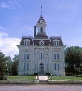
in 1859. In 1873 the city's French Renaissance style Chase County courthouse was built; at roughly the same time, the Atchison, Topeka and Santa Fe Railway
reached Cottonwood Falls. Through the late 19th and early 20th centuries the area around the city was mainly divided into farms and cattle ranches.
crashed ten miles south of Cottonwood Falls near the community of Bazaar
, killing all eight on board, including Notre Dame University football coach Knute Rockne
. A monument to the crash is located on private property.
There has been numerous floods during the history of Cottonwood Falls. In June and July 1951, due to heavy rains, rivers and streams flooded numerous cities in Kansas, including Cottonwood Falls. Many reservoirs and levees were built in Kansas as part of a response to the Great Flood of 1951
.
, the city has a total area of 0.6 square miles (1.6 km²), all of it land, except Spring Creek and Cottonwood River.
(NRHP).
As of the census
of 2000, there were 966 people, 375 households, and 227 families residing in the city. The population density
was 1,674.9 people per square mile (643.1/km²). There were 427 housing units at an average density of 740.3 per square mile (284.3/km²). The racial makeup of the city was 94.93% White, 2.38% African American, 1.14% Native American, 0.21% Asian, 0.83% from other races
, and 0.52% from two or more races. Hispanic or Latino of any race were 2.38% of the population.
There were 375 households out of which 28.3% had children under the age of 18 living with them, 47.2% were married couples
living together, 11.7% had a female householder with no husband present, and 39.2% were non-families. 34.4% of all households were made up of individuals and 20.5% had someone living alone who was 65 years of age or older. The average household size was 2.27 and the average family size was 2.93.
In the city the population was spread out with 23.2% under the age of 18, 6.1% from 18 to 24, 29.6% from 25 to 44, 18.1% from 45 to 64, and 23.0% who were 65 years of age or older. The median age was 39 years. For every 100 females there were 91.7 males. For every 100 females age 18 and over, there were 90.7 males.
The median income for a household in the city was $28,947, and the median income for a family was $37,986. Males had a median income of $27,639 versus $19,167 for females. The per capita income
for the city was $15,166. About 8.8% of families and 11.6% of the population were below the poverty line, including 15.0% of those under age 18 and 8.6% of those age 65 or over.
Cottonwood Falls is part of the Emporia
Micropolitan Statistical Area
.
284.
. For 2010/2011 seasons, the football team competes as Class 2A.
highway passes north-south through the city.
Chase County Airport, FAA:9K0, located south-east of 8th St and Airport Rd.
Schools
Historical
Lodging
Maps
County seat
A county seat is an administrative center, or seat of government, for a county or civil parish. The term is primarily used in the United States....
of Chase County
Chase County, Kansas
Chase County is a county located in Central Kansas, in the Central United States. As of the 2010 census, the county population was 2,790. Its county seat and most populous city is Cottonwood Falls. Chase County is part of the Emporia Micropolitan Statistical Area.The county has been the subject...
, Kansas
Kansas
Kansas is a US state located in the Midwestern United States. It is named after the Kansas River which flows through it, which in turn was named after the Kansa Native American tribe, which inhabited the area. The tribe's name is often said to mean "people of the wind" or "people of the south...
. As of the 2010 census, the city population was 903.
History
19th century
The first settlement in the area of Cottonwood Falls was in 1854, when an Indian trader named Seth Hayes founded a cattle ranch on the Cottonwood River close to the mouth of Diamond Spring Creek. The area around the town was organized as Chase CountyChase County, Kansas
Chase County is a county located in Central Kansas, in the Central United States. As of the 2010 census, the county population was 2,790. Its county seat and most populous city is Cottonwood Falls. Chase County is part of the Emporia Micropolitan Statistical Area.The county has been the subject...
in 1859. In 1873 the city's French Renaissance style Chase County courthouse was built; at roughly the same time, the Atchison, Topeka and Santa Fe Railway
Atchison, Topeka and Santa Fe Railway
The Atchison, Topeka and Santa Fe Railway , often abbreviated as Santa Fe, was one of the larger railroads in the United States. The company was first chartered in February 1859...
reached Cottonwood Falls. Through the late 19th and early 20th centuries the area around the city was mainly divided into farms and cattle ranches.
20th century
In 1931, Transcontinental & Western Air Flight 599TWA Flight 599
Transcontinental and Western Air Flight 599 was a Fokker F.10 Trimotor en route from Kansas City, Missouri, to Los Angeles, California, on March 31, 1931. It crashed a few miles north west of Bazaar, Kansas; all eight on board died...
crashed ten miles south of Cottonwood Falls near the community of Bazaar
Bazaar, Kansas
Bazaar is an unincorporated community in Chase County, Kansas, United States. The community is part of the Emporia Micropolitan Statistical Area. It is notable for being near the place of the 1931 Trans World Airlines Flight 599 crash that killed University of Notre Dame coach Knute Rockne...
, killing all eight on board, including Notre Dame University football coach Knute Rockne
Knute Rockne
Knute Kenneth Rockne was an American football player and coach. He is regarded as one of the greatest coaches in college football history...
. A monument to the crash is located on private property.
There has been numerous floods during the history of Cottonwood Falls. In June and July 1951, due to heavy rains, rivers and streams flooded numerous cities in Kansas, including Cottonwood Falls. Many reservoirs and levees were built in Kansas as part of a response to the Great Flood of 1951
Great Flood of 1951
In mid-July 1951, heavy rains led to a great rise of water in the Kansas River and other surrounding areas. Flooding resulted in the Kansas, Neosho, Marais Des Cygnes, and Verdigris river basins. The damage in June and July 1951 exceeded $935 million dollars in an area covering eastern Kansas and...
.
Geography
Cottonwood Falls is located at 38°22′5"N 96°32′35"W (38.368159, -96.542918). According to the United States Census BureauUnited States Census Bureau
The United States Census Bureau is the government agency that is responsible for the United States Census. It also gathers other national demographic and economic data...
, the city has a total area of 0.6 square miles (1.6 km²), all of it land, except Spring Creek and Cottonwood River.
Area attractions
Cottonwood Falls has five listings on the National Register of Historic PlacesNational Register of Historic Places
The National Register of Historic Places is the United States government's official list of districts, sites, buildings, structures, and objects deemed worthy of preservation...
(NRHP).
- Cartter Building (NRHPNational Register of Historic PlacesThe National Register of Historic Places is the United States government's official list of districts, sites, buildings, structures, and objects deemed worthy of preservation...
). - Chase County Courthouse (NRHPNational Register of Historic PlacesThe National Register of Historic Places is the United States government's official list of districts, sites, buildings, structures, and objects deemed worthy of preservation...
). It is the oldest courthouse in continual use in the state of Kansas and one of the oldest in continual use West of the MississippiMississippi RiverThe Mississippi River is the largest river system in North America. Flowing entirely in the United States, this river rises in western Minnesota and meanders slowly southwards for to the Mississippi River Delta at the Gulf of Mexico. With its many tributaries, the Mississippi's watershed drains...
. - Chase County National Bank (NRHPNational Register of Historic PlacesThe National Register of Historic Places is the United States government's official list of districts, sites, buildings, structures, and objects deemed worthy of preservation...
). - Cottonwood River Bridge (NRHPNational Register of Historic PlacesThe National Register of Historic Places is the United States government's official list of districts, sites, buildings, structures, and objects deemed worthy of preservation...
). - Samuel N Wood House (NRHPNational Register of Historic PlacesThe National Register of Historic Places is the United States government's official list of districts, sites, buildings, structures, and objects deemed worthy of preservation...
). - Kansas Historical Marker - A Landmark Of Distinction, located in courthouse square.
- Chase Lake Falls
Demographics
Cottonwood Falls's population was estimated to be in the year , .As of the census
Census
A census is the procedure of systematically acquiring and recording information about the members of a given population. It is a regularly occurring and official count of a particular population. The term is used mostly in connection with national population and housing censuses; other common...
of 2000, there were 966 people, 375 households, and 227 families residing in the city. The population density
Population density
Population density is a measurement of population per unit area or unit volume. It is frequently applied to living organisms, and particularly to humans...
was 1,674.9 people per square mile (643.1/km²). There were 427 housing units at an average density of 740.3 per square mile (284.3/km²). The racial makeup of the city was 94.93% White, 2.38% African American, 1.14% Native American, 0.21% Asian, 0.83% from other races
Race (United States Census)
Race and ethnicity in the United States Census, as defined by the Federal Office of Management and Budget and the United States Census Bureau, are self-identification data items in which residents choose the race or races with which they most closely identify, and indicate whether or not they are...
, and 0.52% from two or more races. Hispanic or Latino of any race were 2.38% of the population.
There were 375 households out of which 28.3% had children under the age of 18 living with them, 47.2% were married couples
Marriage
Marriage is a social union or legal contract between people that creates kinship. It is an institution in which interpersonal relationships, usually intimate and sexual, are acknowledged in a variety of ways, depending on the culture or subculture in which it is found...
living together, 11.7% had a female householder with no husband present, and 39.2% were non-families. 34.4% of all households were made up of individuals and 20.5% had someone living alone who was 65 years of age or older. The average household size was 2.27 and the average family size was 2.93.
In the city the population was spread out with 23.2% under the age of 18, 6.1% from 18 to 24, 29.6% from 25 to 44, 18.1% from 45 to 64, and 23.0% who were 65 years of age or older. The median age was 39 years. For every 100 females there were 91.7 males. For every 100 females age 18 and over, there were 90.7 males.
The median income for a household in the city was $28,947, and the median income for a family was $37,986. Males had a median income of $27,639 versus $19,167 for females. The per capita income
Per capita income
Per capita income or income per person is a measure of mean income within an economic aggregate, such as a country or city. It is calculated by taking a measure of all sources of income in the aggregate and dividing it by the total population...
for the city was $15,166. About 8.8% of families and 11.6% of the population were below the poverty line, including 15.0% of those under age 18 and 8.6% of those age 65 or over.
Cottonwood Falls is part of the Emporia
Emporia, Kansas
Emporia is a city in and the county seat of Lyon County, Kansas, United States. As of the 2010 census, the city population was 24,916. Emporia lies between Topeka and Wichita at the intersection of U.S. Route 50 with Interstates 335 and 35 on the Kansas Turnpike...
Micropolitan Statistical Area
Emporia micropolitan area
The Emporia Micropolitan Statistical Area, as defined by the United States Census Bureau, is an area consisting of two counties in Kansas, anchored by the city of Emporia....
.
City
The Cottonwood Falls government consists of a mayor and five council members. The council meets the 1st and 3rd Monday of each month at 7PM. City Council Members are elected in odd-numbered years and serve a four-year term.- City Hall, 220 Broadway St.
County
- Chase County Courthouse, Broadway St.
- Chase County Sheriff Department, 201 Walnut St.
- Chase County Fire Department, 201 Walnut.
U.S.
- U.S. Post Office, 206 Broadway St.
- U.S. Consolidated Farm Service Agency, 219 Broadway St.
- National Park Service (U.S. Dept of Interior), 226 Broadway St.
Primary and secondary education
Cottonwood Falls is part of Unified School DistrictUnified school district
A unified school district or unit school district is a school district which includes both primary school and high school under the same district control....
284.
- Chase County Junior/Senior High SchoolChase County Junior/Senior High SchoolChase County Junior/Senior High School is a public secondary school in Cottonwood Falls, Kansas, USA. It is one of two schools operated by Unified School District 284, and is the sole high school in the district.-History:...
, 600 Main St. - Chase County Elementary School, 401 Maple St.
Sports
The Chase County High School mascot is a Bulldog. All high school athletic and non-athletic competition is overseen by the Kansas State High School Activities AssociationKansas State High School Activities Association
The Kansas State High School Activities Association is the organization which oversees interscholastic competition in the state of Kansas at the high school level. It oversees both athletic and non-athletic competition, and sponsors championships in several sports and activities.The KSHSAA was...
. For 2010/2011 seasons, the football team competes as Class 2A.
Transportation
K-177K-177 (Kansas highway)
K-177 is a state highway in central Kansas. It runs from US-54 near El Dorado to Manhattan, passing through the Flint Hills. It is part of the Flint Hills Scenic Byway and the Prairie Parkway.-Route description:...
highway passes north-south through the city.
Chase County Airport, FAA:9K0, located south-east of 8th St and Airport Rd.
Utilities
- Internet
- Satellite Internet is provided by HughesNet, StarBandStarBandStarBand is a two-way satellite broadband Internet service available in the U.S.. StarBand Communications Inc. was initially a joint venture between Gilat Satellite Networks, EchoStar and Microsoft, and the StarBand service was launched in 2000. StarBand Communications filed for Chapter 11...
, WildBlue.
- Satellite Internet is provided by HughesNet, StarBand
- TV
- Satellite TV is provided by DirecTVDirecTVDirecTV is an American direct broadcast satellite service provider and broadcaster based in El Segundo, California. Its satellite service, launched on June 17, 1994, transmits digital satellite television and audio to households in the United States, Latin America, and the Anglophone Caribbean. ...
, Dish NetworkDish NetworkDish Network Corporation is the second largest pay TV provider in the United States, providing direct broadcast satellite service—including satellite television, audio programming, and interactive television services—to 14.337 million commercial and residential customers in the United States. Dish...
. - Free over-the-air ATSCATSCATSC standards are a set of standards developed by the Advanced Television Systems Committee for digital television transmission over terrestrial, cable, and satellite networks....
digital TVDigital televisionDigital television is the transmission of audio and video by digital signals, in contrast to the analog signals used by analog TV...
.
- Satellite TV is provided by DirecTV
See also
- National Register of Historic Places listings in Chase County, KansasNational Register of Historic Places listings in Chase County, KansasThis is a list of the National Register of Historic Places listings in Chase County, Kansas.This is intended to be a complete list of the properties and districts on the National Register of Historic Places in Chase County, Kansas, United States...
- Chase County Courthouse
- Chase County Junior/Senior High SchoolChase County Junior/Senior High SchoolChase County Junior/Senior High School is a public secondary school in Cottonwood Falls, Kansas, USA. It is one of two schools operated by Unified School District 284, and is the sole high school in the district.-History:...
- Cottonwood River
- Great Flood of 1951Great Flood of 1951In mid-July 1951, heavy rains led to a great rise of water in the Kansas River and other surrounding areas. Flooding resulted in the Kansas, Neosho, Marais Des Cygnes, and Verdigris river basins. The damage in June and July 1951 exceeded $935 million dollars in an area covering eastern Kansas and...
Further reading
- History of the State of Kansas; William G. Cutler; A.T. Andreas Publisher; 1883. (Online HTML eBook)
- Kansas : A Cyclopedia of State History, Embracing Events, Institutions, Industries, Counties, Cities, Towns, Prominent Persons, Etc; 3 Volumes; Frank W. Blackmar; Standard Publishing Co; 944 / 955 / 824 pages; 1912. (Volume1 - Download 54MB PDF eBook),(Volume2 - Download 53MB PDF eBook), (Volume3 - Download 33MB PDF eBook)
External links
City- City of Cottonwood Falls
- Cottonwood Falls - Directory of Public Officials
- Cottonwood Falls - Information, Skyways
Schools
- USD 284, school district for all of Chase CountyChase County, KansasChase County is a county located in Central Kansas, in the Central United States. As of the 2010 census, the county population was 2,790. Its county seat and most populous city is Cottonwood Falls. Chase County is part of the Emporia Micropolitan Statistical Area.The county has been the subject...
.
Historical
- 1912 Encyclopedia of Kansas article on Chase County
- TWA Flight 599 Memorial, Knute Rockne crash site.
- Historic Images of Cottonwood Falls, Special Photo Collections at Wichita State University Library.
Lodging
Maps