

Cordillera Central, Colombia
Encyclopedia
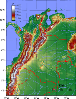
The Cordillera Central range is one of the three branches of ridges in the Andes Mountains that split in southern Colombia
Colombia
Colombia, officially the Republic of Colombia , is a unitary constitutional republic comprising thirty-two departments. The country is located in northwestern South America, bordered to the east by Venezuela and Brazil; to the south by Ecuador and Peru; to the north by the Caribbean Sea; to the...
towards the north up to the Montes de Maria
Montes de María
The Montes de María are a group of mountains of the northern coast of Colombia , which do not belong to the Andes ranges, and the highlands around them. The Montes de María are the last part of the Serranía de San Jerónimo.Montes de María is a zone located in the center of the Colombian...
.
It extends from the Nudo de Almaguer, or the "Colombian Mountain Mass" in Cauca
Cauca Department
Cauca is a Department of Colombia. Located in the south-western part of the country, facing the Pacific Ocean to the west, the Valle del Cauca Department to the north, Tolima Department to the northeast, Huila Department to the east and the Nariño Department to the south, covering a total area of...
, located in southern Colombia, to the Serranía de San Lucas in Bolivar
Bolívar Department
Bolívar is a department of Colombia. It was named after one of the original nine states of the United States of Colombia. It is located to the north of the country, extending from the coast at Cartagena near the mouth of the Magdalena River, then south along the river to a border with Antioquia.Its...
to the north. The range is bounded by the Cauca
Cauca River
The Cauca River is a river in Colombia that lies between the Occidental and Central cordilleras. Born in southwestern Colombia near the city of Popayán, it joins the Magdalena River near Pinillos in Bolívar Department, and the combined river eventually flows out into the Caribbean Sea. It has a...
and Magdalena
Magdalena River
The Magdalena River is the principal river of Colombia, flowing northward about through the western half of the country. It takes its name from the biblical figure Mary Magdalene. It is navigable through much of its lower reaches, in spite of the shifting sand bars at the mouth of its delta, as...
river valleys to the west and east, respectively.
Cordillera Central is home to the Eje cafetero region as well as several volcano
Volcano
2. Bedrock3. Conduit 4. Base5. Sill6. Dike7. Layers of ash emitted by the volcano8. Flank| 9. Layers of lava emitted by the volcano10. Throat11. Parasitic cone12. Lava flow13. Vent14. Crater15...
es, including the Nevado del Ruiz
Nevado del Ruiz
The Nevado del Ruiz, also known as La Mesa de Herveo or Kumanday in the language of the local pre-Columbian indigenous people, is a volcano located on the border of the departments of Caldas and Tolima in Colombia, about west of the capital city Bogotá. It is a stratovolcano, composed of many...
as well as the volcanoes Santa Isabel
Santa Isabel (volcano)
Santa Isabel is a shield volcano located in Tolima Department, Colombia, southwest of Nevado del Ruiz volcano....
, Nevado del Huila
Nevado del Huila
Nevado del Huila , at , is the highest volcano in Colombia, located in Huila Department. After being dormant for more than 500 years, the volcano showed heavy signs of activity in 2007 and 2008. As of February 20, 2007, there were more than 7000 "minor" seismic events, and a high state of...
, and Nevado del Tolima
Nevado del Tolima
Nevado del Tolima is a stratovolcano located in Tolima Department, Colombia, south of Nevado del Ruiz volcano.The steep-sided, glacier-clad Nevado del Tolima volcano contrasts with the broad profile of Nevado del Ruiz volcano to the north...
.
Hydrography
- Río Magdalena (Principal Colombian river)
- Río Cauca
- Río Caquetá
- Río Patía
- Río Saldaña
- Río Nima
- Río Amaime
- Río Tulúa
- Río Amoyá
- Río Davis Cambrín
- Río Anamichú

- Laguna del Otún
- Laguna VerdeLaguna VerdeLaguna Verde is the Spanish language form of green lagoon or green lake. There are many places, lakes and lagoons that take this name due to the presence of green colored waters...
- Río Otún
- Río Totarito
- Río Molinas
- Río Azufrado
- Río Lagunillas
- Río Azul
- Río Barbo
- Río La Miel, in the oriental part and ends in the Magdalena River
- Río Samaná Sur
- Río Medellín
- Río Nechí
See also
- Caldas DepartmentCaldas DepartmentCaldas is a department of Colombia named after Colombian patriotic figure Francisco José de Caldas. It's part of the Paisa Region and its capital is Manizales. The population of Caldas is 1,030,062, and its area is 7,291 km²...
- Cordillera Occidental (Colombia)
- Cordillera Oriental (Colombia)
- Cordillera CentralCordillera CentralThe Cordillera Central, meaning central range in Spanish, is used to refer to several mountain ranges around the world:* Cordillera Central, Andes , several mountain ranges in South America** Cordillera Central, Colombia...