

Coquet Stop Line
Encyclopedia
Amble
Amble is a town, civil parish and seaport on the North Sea coast, in Northumberland, England. It lies at the mouth of the River Coquet, and the nearby Coquet Island is clearly visible from its beaches and harbour. The civil parish, which has town status, is called Amble by the Sea, and has a...
in Northumberland
Northumberland
Northumberland is the northernmost ceremonial county and a unitary district in North East England. For Eurostat purposes Northumberland is a NUTS 3 region and is one of three boroughs or unitary districts that comprise the "Northumberland and Tyne and Wear" NUTS 2 region...
up the valley of the River Coquet
River Coquet
The River Coquet runs through the county of Northumberland, England, discharging into the North Sea on the east coast of England at Amble. Warkworth Castle is built in a loop of the Coquet....
, formed part of the defences constructed to meet the threat of a Nazi
Nazi Germany
Nazi Germany , also known as the Third Reich , but officially called German Reich from 1933 to 1943 and Greater German Reich from 26 June 1943 onward, is the name commonly used to refer to the state of Germany from 1933 to 1945, when it was a totalitarian dictatorship ruled by...
invasion during World War II
World War II
World War II, or the Second World War , was a global conflict lasting from 1939 to 1945, involving most of the world's nations—including all of the great powers—eventually forming two opposing military alliances: the Allies and the Axis...
. It was intended to slow the advance of the German army from the north to give time for a field army to assemble on the Tyne Stop Line
Tyne Stop Line
The Tyne Stop Line, which ran from the Rede Valley in Northumberland to Newcastle upon Tyne, formed part of the defences constructed to meet the threat of a Nazi invasion during World War II...
around 30 miles to the south.
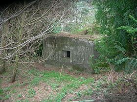
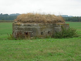
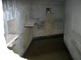
The Coquet Stop Line was made up of a string of pillboxes
British hardened field defences of World War II
British hardened field defences of World War II were small fortified structures constructed as a part of British anti-invasion preparations. They were popularly known as pillboxes by reference to their shape.-Design and development:...
, with a consistent shape that has been referred to as the "Coquet line type" or more accurately "Lozenge" type, and is only found in the North East and parts of Yorkshire. They tend to have open ground in front, often the river or its floodplain, while to the rear, where the entrance is, efforts were made to provide cover for a retreating force.
A few of these pillboxes have been lost: one on the approach to Felton village and another on the west side of the A1 at West Moor have gone. The remains of a sandbag pillbox on the north side of Amble Harbour lie opposite a large concrete block that was built for a harbour chain. There is a brick "Lozenge" near the football pitch in Warkworth, though this is more likely part of the "Coastal Crust".
Other pillboxes in the area
There are several other pillboxes on the Coquet, although these were probably not built as part of the Stop Line. One sandbag "Beehive" type pillbox is in a garden just behind the Cross Keys public house in Thropton. It covers the west approach to the Wreigh Burn road bridge. It was built by the 250th Field Company of Royal Engineers. They built many sandbag pillboxes in the area between July and September 1940; but the concrete pillboxes were put out to local tender.There is another pillbox near Morwick on the west side of the east coast main line. It is rectangular, half brick and half concrete, and was probably built to defend the railway viaduct or to protect the soldiers who would have been ordered to blow up the viaduct in the event of an invasion. The viaduct would have had to be kept open as long as possible to allow rolling stock to be moved.
A unique pillbox can be found by the road from Amble to Warkworth at Gloster Hill. This is a stone-fronted pillbox in the shape of an old cottage (similar to one at Hemscott Hill, Cresswell). It has a stone and concrete front and the rest is made up of sandbags.
The pillboxes at Brainshaugh and West Thirston may not be part of the Coquet stopline, as their ID numbers are out of sequence with the others. They may have formed an inland stop line running north to south. The pillboxes at Hazon, Brainshaugh, Morwick, West Thirston, Earsdon, Longhirst, Bothal Barns and East Moor (and possibly Eshott) form a line with the pillboxes approximately two miles apart.
There is a further modified lozenge pillbox in Rothbury. It is a standard "lozenge" except for an alteration to the porch and door, which were built on the left hand side as opposed to the rear. The pillbox is well hidden on the south side of the river. It is almost opposite the Whitton road bridge and was sited to defend the bridge. The front three embrasures are just above ground level, with left and right one having been letterboxed. The pillbox has no ID number so it may not be part of the stopline. It is at grid reference NU0560 0160.
Locations of pillboxes
The following pillboxes have been firmly identified as part of the Coquet Stop Line. They are listed from east to west. The listing of a pillbox here does not imply any right to visit the sites, which are almost all on private land.| ID | Location | Grid Reference | Notes |
|---|---|---|---|
| P454 | West Thirston | ||
| P305 | Catheugh Plantation | ||
| P306 | Weldon Bridge | ||
| P307 | Brinkheugh | ||
| P308 | Middleheugh, Brinkburn Priory | ||
| P309 | Pauperhaugh | ||
| P310 | Brinkburn Station | ||
| P311 | Rothbury school area | removed | |
| P312 | Cartington near Rothbury | This is on Garleigh Moor, not in Cartington itself, which is near Snitter to the NW | |
| P313 | Carterside near Rothbury | ||
| P314 | Newtown | ||
| P315 | Ryehill | ||
| P318 | Little Tosson | ||
| P319 | Bickerton | ||
| P320 | Bickerton | ||
| P321 | Hepple | Significant subsidence due to river | |
| P322 | Hepple | ||
| P323 | Harehaugh | ||
| P--- | Brainshaugh (north of the river) | ||
| P583 | Morwick | ||
| P--- | Rothbury |
See also
- British anti-invasion preparations of World War IIBritish anti-invasion preparations of World War IIBritish anti-invasion preparations of the Second World War entailed a large-scale division of military and civilian mobilisation in response to the threat of invasion by German armed forces in 1940 and 1941. The British army needed to recover from the defeat of the British Expeditionary Force in...
- British hardened field defences of World War IIBritish hardened field defences of World War IIBritish hardened field defences of World War II were small fortified structures constructed as a part of British anti-invasion preparations. They were popularly known as pillboxes by reference to their shape.-Design and development:...
- Taunton Stop LineTaunton Stop LineThe Taunton Stop Line was a World War II defensive line in south west England. It was designed "to stop an enemy's advance from the west and in particular a rapid advance supported by armoured fighting vehicles which may have broken through the forward defences."The Taunton Stop Line was one of...
- GHQ LineGHQ LineThe GHQ Line was a defence line built in the United Kingdom during World War II to contain an expected German invasion.The British Army had abandoned most of its equipment in France after the Dunkirk evacuation...
- Outer London Defence RingOuter London Defence RingThe Outer London Defence Ring was a defensive ring built around London during the early part of the Second World War. It was intended as a defence against a German invasion, and was part of a national network of similar "Stop Lines"....
- Bridgwater and Taunton CanalBridgwater and Taunton CanalThe Bridgwater and Taunton Canal is a canal in the south-west of England between Bridgwater and Taunton, opened in 1827 and linking the River Tone to the River Parrett. There were a number of abortive schemes to link the Bristol Channel to the English Channel by waterway in the 18th and early 19th...