

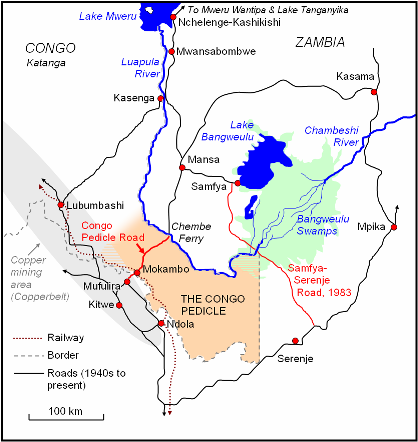
Congo Pedicle road
Encyclopedia
Congo Pedicle
The Congo Pedicle refers to the southeast salient of the Katanga Province of the Democratic Republic of Congo which sticks into neighbouring Zambia almost dividing it into two lobes, like the wings of a butterfly. In area the pedicle is similar in size to Wales or New Jersey...
and was constructed by and is maintained by Zambia
Zambia
Zambia , officially the Republic of Zambia, is a landlocked country in Southern Africa. The neighbouring countries are the Democratic Republic of the Congo to the north, Tanzania to the north-east, Malawi to the east, Mozambique, Zimbabwe, Botswana and Namibia to the south, and Angola to the west....
to connect its Copperbelt
Copperbelt Province
Copperbelt Province in Zambia covers the mineral-rich Copperbelt, and farming and bush areas to the south. It was the backbone of the Northern Rhodesian economy during British colonial rule and fuelled the hopes of the immediate post-independence period, but its economic importance was severely...
and Luapula Province
Luapula Province
Luapula Province is one of Zambia's nine provinces, and is located in the north of the country. The provincial capital is Mansa. Luapula Province was named after the Luapula River....
s. Both the road and the territory may be referred to as ‘the Pedicle’.
For thirty years, the Congo Pedicle road has been a major development
Development studies
Development studies is a multidisciplinary branch of social science which addresses issues of concern to developing countries. It has historically placed a particular focus on issues related to social and economic development, and its relevance may therefore extend to communities and regions...
issue in northern Zambia. This article covers the road, for details of how the territory came in to being, see Congo Pedicle
Congo Pedicle
The Congo Pedicle refers to the southeast salient of the Katanga Province of the Democratic Republic of Congo which sticks into neighbouring Zambia almost dividing it into two lobes, like the wings of a butterfly. In area the pedicle is similar in size to Wales or New Jersey...
.
The need for a crossing of the Pedicle
From its inception, the Pedicle was crossed by those travelling between the LuapulaLuapula River
The Luapula River is a section of Africa's second-longest river, the Congo. It is a transnational river forming for nearly all its length part of the border between Zambia and the DR Congo...
, Mweru
Lake Mweru
Lake Mweru is a freshwater lake on the longest arm of Africa's second-longest river, the Congo. Located on the border between Zambia and Democratic Republic of the Congo, it makes up 110 km of the total length of the Congo, lying between its Luapula River and Luvua River segments.Mweru...
and Bangweulu
Lake Bangweulu
Bangweulu — 'where the water sky meets the sky' — is one of the world's great wetland systems, comprising Lake Bangweulu, the Bangweulu Swamps and the Bangweulu Flats or floodplain...
areas and the south, especially after the railway reached Ndola
Ndola
Ndola is the third largest city in Zambia, with a population of 495,000 . It is the industrial, commercial, on the Copperbelt, Zambia's copper-mining region, and capital of Copperbelt Province. It is also the commercial capital city of Zambia and has one of the three international airports, others...
in 1906. But there were other routes. In the 19th Century the more travelled trade route from those areas had been to the south end of Lake Tanganyika
Lake Tanganyika
Lake Tanganyika is an African Great Lake. It is estimated to be the second largest freshwater lake in the world by volume, and the second deepest, after Lake Baikal in Siberia; it is also the world's longest freshwater lake...
, by boat up the lake to Ujiji
Ujiji
Ujiji is the oldest town in western Tanzania, located about 6 miles south of Kigoma. In 1900, the population was estimated at 10,000 and in 1967 about 4,100. Part of the Kigoma/Ujiji urban area, the regional population was about 50,000 in 1978....
, overland to Dar Es Salaam
Dar es Salaam
Dar es Salaam , formerly Mzizima, is the largest city in Tanzania. It is also the country's richest city and a regionally important economic centre. Dar es Salaam is actually an administrative province within Tanzania, and consists of three local government areas or administrative districts: ...
, and by boat to Zanzibar
Zanzibar
Zanzibar ,Persian: زنگبار, from suffix bār: "coast" and Zangi: "bruin" ; is a semi-autonomous part of Tanzania, in East Africa. It comprises the Zanzibar Archipelago in the Indian Ocean, off the coast of the mainland, and consists of numerous small islands and two large ones: Unguja , and Pemba...
. Completion of the Dar es Salaam railway to Kigoma
Kigoma
Kigoma is a town and lake port in western Tanzania, on the eastern shore of Lake Tanganyika and close to the border with Burundi. It serves as the capital for the surrounding Kigoma Region and has a population of 135,234 and an elevation of 775 m.The historic trading town of Ujiji is 6 km...
near Ujiji in 1914, coupled with a lake steamer service to Mpulungu
Mpulungu
Mpulungu is a town in the Northern Province of Zambia, at the southern tip of Lake Tanganyika.From Mpulungu, boats reach DR Congo, Tanzania and Burundi...
near Abercorn made it even more viable.
The Copperbelt
Development of the Copperbelt from the late 1920s had a big impact on overland routes. Copperbelt towns including Elizabethville (now 'Lubumbashi')Lubumbashi
Lubumbashi is the second largest city in the Democratic Republic of the Congo, second only to the nation's capital Kinshasa, and the hub of the southeastern part of the country. The copper-mining city serves as the capital of the relatively prosperous Katanga Province, lying near the Zambian border...
in the Congolese province of Katanga
Katanga Province
Katanga Province is one of the provinces of the Democratic Republic of the Congo. Between 1971 and 1997, its official name was Shaba Province. Under the new constitution, the province was to be replaced by four smaller provinces by February 2009; this did not actually take place.Katanga's regional...
became the markets and chief source of supplies and employment for the Luapula-Mweru-Bangweulu region, and in turn their large fisheries (the largest in Northern Rhodesia
Northern Rhodesia
Northern Rhodesia was a territory in south central Africa, formed in 1911. It became independent in 1964 as Zambia.It was initially administered under charter by the British South Africa Company and formed by it in 1911 by amalgamating North-Western Rhodesia and North-Eastern Rhodesia...
/Zambia
Zambia
Zambia , officially the Republic of Zambia, is a landlocked country in Southern Africa. The neighbouring countries are the Democratic Republic of the Congo to the north, Tanzania to the north-east, Malawi to the east, Mozambique, Zimbabwe, Botswana and Namibia to the south, and Angola to the west....
) supplied the growing Copperbelt labour force.
The Katanga route
However it was Elizabethville and Katanga which benefited initially, via a road to the Congolese port of Kasenga on the Luapula, and another to a ferry at Shiniama across the Luapula near Matanda and on to Fort Rosebery (Mansa)Mansa
Mansa is a Mandinka word meaning "king of kings". It is particularly associated with the Keita Dynasty of the Mali Empire, which dominated West Africa from the thirteenth to the fifthteenth century...
. There was migration from Luapula Province to Katanga, and some of Mwata Kazembe's people looked to Elizabethville for employment and advancement rather than Mufulira, Kitwe
Kitwe
Kitwe is the second largest city in terms of size and population in Zambia. With a population of 547,700 Kitwe is one of the most developed commercial and industrial areas in the nation, alongside Ndola and Lusaka...
and Ndola. The Northern Rhodesia authorities and mines were slower to catch on, and when dried fish was bought for their workforce from Katanga, it may well have been caught in Northern Rhodesian waters of Lake Mweru, Lake Mweru Wantipa
Lake Mweru Wantipa
Lake Mweru Wantipa is a lake and swamp system in the Northern Province of Zambia. It has been regarded in the past as something of mystery, displaying fluctuations in water level and salinity which were not entirely explained by variation in rainfall levels; it has been known to dry out almost...
, south-west Lake Tanganyika
Lake Tanganyika
Lake Tanganyika is an African Great Lake. It is estimated to be the second largest freshwater lake in the world by volume, and the second deepest, after Lake Baikal in Siberia; it is also the world's longest freshwater lake...
or even Lake Bangweulu. There was a road from Ndola
Ndola
Ndola is the third largest city in Zambia, with a population of 495,000 . It is the industrial, commercial, on the Copperbelt, Zambia's copper-mining region, and capital of Copperbelt Province. It is also the commercial capital city of Zambia and has one of the three international airports, others...
across the border to Sakania in the Congo, and a dirt road to a small ferry over the Luapula at Kapalala, but it was not a direct route, took at least a day to travel, and was not suitable for the heavier vehicles. Eventually in the late 1940s the Northern Rhodesia government realised the need for a larger, direct road from the Copperbelt to Fort Rosebery (Mansa)
Mansa
Mansa is a Mandinka word meaning "king of kings". It is particularly associated with the Keita Dynasty of the Mali Empire, which dominated West Africa from the thirteenth to the fifthteenth century...
with a higher-capacity ferry over the Luapula.
Construction of the Congo Pedicle
Negotiations with the Belgian colonial authorities produced an agreement for Northern Rhodesia to build and maintain a 70-km graded lateriteLaterite
Laterites are soil types rich in iron and aluminium, formed in hot and wet tropical areas. Nearly all laterites are rusty-red because of iron oxides. They develop by intensive and long-lasting weathering of the underlying parent rock...
road from Mokambo (16 km from the Copperbelt town of Mufulira
Mufulira
Mufulira is a town in the Copperbelt Province of Zambia. It grew up in the 1930s around the site of the Mufulira Copper Mine on its north-western edge...
) to Chembe
Chembe
Chembe is a small town in Milenge District of the Luapula Province of Zambia, which owes its existence to being the site of the Chembe Ferry across the Luapula River dividing Zambia and the Congo Pedicle territory of DR Congo...
. Although only used by Northern Rhodesia and with no Congolese settlements except Mokambo on its route, it had border control posts at both ends and traffic drove on the right. By the 1950s the Chembe Ferry had two motorised pontoons able to take the largest trucks, the border posts worked smoothly and the 174-km drive from Mufulira
Mufulira
Mufulira is a town in the Copperbelt Province of Zambia. It grew up in the 1930s around the site of the Mufulira Copper Mine on its north-western edge...
to Mansa could be completed in four or five hours. By comparison the same journey keeping to roads within the country was 1166 km and took at least two days, going via Kapiri Mposhi
Kapiri Mposhi
Kapiri Mposhi is a small town in Zambia. Located north of Lusaka, it stands on the Great North Road and is significant for the railway connection between Zambia Railways line from Kitwe to Lusaka and Livingstone and western terminal of the Tanzania-Zambia Railway Authority from Dar-es-Salaam since...
, Mpika
Mpika
Mpika is a town in the Northern Province of Zambia, lying at the junction of the Great North Road to Kasama and Mbala and the Tanzam Highway to Dar es Salaam, Tanzania. It also has a railway station on the TAZARA Railway about 5 km away. Mpika is situated between the Muchinga Escarpment to...
, Kasama
Kasama
The toponym Kasama may refer to:* Kasama, Ibaraki , Japan* Kasama, Zambia* Kasama Project- See also :Related toponym:* Kazama * Kazami* Kazemi* Hazama...
and Luwingu.
In the past four decades the superiority of the Katangan roads has reversed, with the Lubumbashi-Kasenga road deteriorating to the extent that it may take several days to reach Kasenga. Congolese travellers and goods frequently cross into the Zambian Copperbelt from Lubumbashi and take the Pedicle or the Samfya-Serenje road to Kasenga.
The Congo crisis
Apart from the Luapula occasionally bursting its banks at Chembe in the rainy season and halting the Chembe Ferry for a few days, this happy state of affairs continued until the Congo CrisisCongo Crisis
The Congo Crisis was a period of turmoil in the First Republic of the Congo that began with national independence from Belgium and ended with the seizing of power by Joseph Mobutu...
of 1961 when travel on the pedicle stopped for security reasons and had to be routed by air or via Kasama. Although the interruption did not last long, it highlighted the vulnerability of the route.
Independence
The Congo became independentIndependence
Independence is a condition of a nation, country, or state in which its residents and population, or some portion thereof, exercise self-government, and usually sovereignty, over its territory....
in 1960 and changed its name to Zaire in 1971, and Northern Rhodesia became independent in 1964, as Zambia. Any thought that two African neighbours with shared tribal, cultural and historical origins could cooperate even better than neighbouring colonial powers was dispelled not long after. The colonial experience
Colonialism
Colonialism is the establishment, maintenance, acquisition and expansion of colonies in one territory by people from another territory. It is a process whereby the metropole claims sovereignty over the colony and the social structure, government, and economics of the colony are changed by...
had broken down those connections which might have smoothed travel by Zambians through Zaire and replaced them with a bureaucracy and leadership whose allegiances had greatly changed and who saw how to exploit regulations and authority for their own gains.
Harassment of travelers
Under Mobutu, governanceGovernance
Governance is the act of governing. It relates to decisions that define expectations, grant power, or verify performance. It consists of either a separate process or part of management or leadership processes...
deteriorated and corruption
Political corruption
Political corruption is the use of legislated powers by government officials for illegitimate private gain. Misuse of government power for other purposes, such as repression of political opponents and general police brutality, is not considered political corruption. Neither are illegal acts by...
flourished in Zaire, and he saw Katanga only as a cash cow
Cash cow
In business, a cash cow is a product or a business unit that generates unusually high profit margins: so high that it is responsible for a large amount of a company's operating profit...
and punished it for its separatist tendencies by neglecting its development. Zairean border officials and police went for months without being paid and turned to petty corruption to survive. At first small bribes were taken from Zambians whose identity cards were not in order, but this escalated to arbitrary fines, for example, a driver might be fined for wearing a hat while his passenger was fined for not wearing a hat
The Pedicle became the major gripe for the people of Luapula Province and they assailed their leaders and officials when they toured the province, such as in a meeting of civil servants in Mansa in 1975 with President Kenneth Kaunda
Kenneth Kaunda
Kenneth David Kaunda, known as KK, served as the first President of Zambia, from 1964 to 1991.-Early life:Kaunda was the youngest of eight children. He was born at Lubwa Mission in Chinsali, Northern Province of Northern Rhodesia, now Zambia...
, when most of the questions were about harassment at the Pedicle.
The situation became more severe when any of Mobutu's security forces were in the Pedicle, with robberies, violence and occasionally the complete disappearance of travellers and their vehicles.
Developing alternative routes
The route by-passing the Pedicle is made longer by Lake Bangweulu and its swamps which extend from its north-east tip for 200 km to the north, and the only route had to go east then north of this system. A route south of the lake was hampered by the fact that the Luapula and its swamps there are at least 6 km wide, and the floodplain is 60 km wide. However the complaints about the Pedicle were so many that the tarred 300-km SamfyaSamfya
Samfya is a town located in the Zambian province of Luapula. It is the center of Samfya District. The town is located on the south-western shore of Lake Bangweulu, on the longest stretch of well-defined shore of that lake...
-Serenje
Serenje
Serenje is a district in Zambia. There is also the town of Serenje lying just off the Great North Road and TAZARA Railway. The British, during the time that Northern Rhodesia was a British protectorate, designated Serenje as a BOMA . To this day, the locals refer to Serenje Town as the BOMA....
road and Luapula Bridge (2.5 km long with nearly 20 km of causeway), one of the biggest infrastructure
Infrastructure
Infrastructure is basic physical and organizational structures needed for the operation of a society or enterprise, or the services and facilities necessary for an economy to function...
projects in the country, were constructed and opened in 1983. The Mufulira-Mansa distance by this route is 718 km, still a lot longer than the Pedicle route but saving 448 km on the Kasama route. From Lusaka and southern Zambia to Mansa the route is very much more attractive.
The future of the Pedicle Road
In the meantime, the laterite Pedicle road has deteriorated but security in the DR Congo has improved. As the cost of fuel has soared and with the Pedicle saving more than 500 km on the Copperbelt-Serenje-Samfya-Mansa distance there is still the need, as there has been for 30 years, to pave the Pedicle and complete the Chembe Bridge. Construction of the bridge started in 2007 for completion in 2008, and President MwanawasaLevy Mwanawasa
Levy Patrick Mwanawasa was the third President of Zambia. He ruled the country from January 2002 until his death in August 2008. He is credited for having initiated a campaign to rid the country of corruption...
has said that paving the road will go ahead, depending on donor funding
Development aid
Development aid or development cooperation is aid given by governments and other agencies to support the economic, environmental, social and political development of developing countries.It is distinguished...
.