

Confederated Salish and Kootenai Tribes of the Flathead Nation
Encyclopedia
Bitterroot Salish (tribe)
The Bitterroot Salish are one of three tribes of the Confederated Salish and Kootenai Tribes of the Flathead Nation in Montana. The Flathead Reservation is home to the Kootenai and Pend d'Oreilles tribes also.-Language:...
, Kootenai
Kootenai (tribe)
The Ktunaxa , also known as Kootenai, Kutenai or Kootenay , are an indigenous people of North America. They are one of three tribes of the Confederated Salish and Kootenai Tribes of the Flathead Nation in Montana, and they form the Ktunaxa Nation in British Columbia...
and Pend d'Oreilles
Pend d'Oreilles (tribe)
The Pend d'Oreilles, also known as the Kalispel, are a tribe of Native Americans who lived around Lake Pend Oreille, as well as the Pend Oreille River, and Priest Lake although some of them live spread throughout Montana and eastern Washington...
Tribes. The Flatheads lived between the Cascade Mountains and Rocky Mountains
Rocky Mountains
The Rocky Mountains are a major mountain range in western North America. The Rocky Mountains stretch more than from the northernmost part of British Columbia, in western Canada, to New Mexico, in the southwestern United States...
. The Salish (Flatheads) initially lived entirely east of the Continental Divide
Continental Divide
The Continental Divide of the Americas, or merely the Continental Gulf of Division or Great Divide, is the name given to the principal, and largely mountainous, hydrological divide of the Americas that separates the watersheds that drain into the Pacific Ocean from those river systems that drain...
but established their headquarters near the eastern slope of the Rocky Mountains. Occasionally hunting parties went west of the Continental Divide but not west of the Bitterroot Range
Bitterroot Range
The Bitterroot Range runs along the border of Montana and Idaho in the northwestern United States. The range spans an area of 62,736 square kilometers and is named after the bitterroot , a small pink flower that is the state flower of Montana.- History :In 1805, the Corps of Discovery,...
. The easternmost edge of their ancestral hunting forays were the Gallatin
Gallatin Range
The Gallatin Range is located in the U.S. states of Montana and Wyoming and includes more than 10 mountains over . The highest peak in the range is Electric Peak at . The Gallatin Range was named after Albert Gallatin, the longest-serving US Secretary of the Treasury and one of the negotiators of...
, Crazy Mountain, and Little Belt Ranges.
They were called the Flathead Indians by the first white men who came to the Genesse River.
The name is often said to derive from the flat head produced by binding infants' skulls with boards. However, this is mistaken folk etymology, as the tribes never practiced head flattening. In fact, the Salish were called "flat head" precisely because the tops of their heads were not distorted, as were those of neighboring tribespeople who practiced vertical head-binding. The sign language used by neighboring tribes to distinguish the Flatheads consisted of "pressing each side of the head" with the hands. The Flatheads call themselves Salish meaning the people.
History
The first written record of the tribes is from their meeting with the Lewis and Clark ExpeditionLewis and Clark Expedition
The Lewis and Clark Expedition, or ″Corps of Discovery Expedition" was the first transcontinental expedition to the Pacific Coast by the United States. Commissioned by President Thomas Jefferson and led by two Virginia-born veterans of Indian wars in the Ohio Valley, Meriwether Lewis and William...
(September 5, 1805). Lewis and Clark came there and bought horses but eventually ate the horses due to starvation. The Flatheads also appear in the records of the Catholic Church at St. Louis
St. Louis, Missouri
St. Louis is an independent city on the eastern border of Missouri, United States. With a population of 319,294, it was the 58th-largest U.S. city at the 2010 U.S. Census. The Greater St...
to which they sent four delegations to request missionaries (or "Black Robes") to minister to the tribe. Their request was finally granted and a number of missionaries including Pierre-Jean De Smet
Pierre-Jean De Smet
Pierre-Jean De Smet , also known as Pieter-Jan De Smet, was a Belgian Roman Catholic priest and member of the Society of Jesus , active in missionary work among the Native Americans of the Midwestern United States in the mid-19th century.His extensive travels as a missionary were said to total...
, S.J., were eventually sent. The flatheads are also located in Sula, Montana (United States, North America).
The tribes negotiated the Hellgate treaty with the United States in 1855. From the start, treaty negotiations were plagued by serious translation problems. A Jesuit observer, Father Adrian Hoecken, said that the translations were so poor that "not a tenth of what was said was understood by either side". But as in the meeting with Lewis and Clark
Lewis and Clark Expedition
The Lewis and Clark Expedition, or ″Corps of Discovery Expedition" was the first transcontinental expedition to the Pacific Coast by the United States. Commissioned by President Thomas Jefferson and led by two Virginia-born veterans of Indian wars in the Ohio Valley, Meriwether Lewis and William...
, the pervasive cross-cultural miscommunication ran even deeper than problems of language and translation. Tribal people came to the meeting assuming they were going to formalize an already-recognized friendship. Non-Indians came with the goal of making official their claims to native lands and resources. Isaac Stevens, the new governor and superintendent of Indian affairs for Washington Territory, was intent on obtaining cession of the Bitterroot Valley
Bitterroot Valley
The Bitterroot Valley is located in southwestern Montana in the northwestern United States. It extends over 100 miles from remote Horse Creek Pass north to a point near the city of Missoula...
from the Salish. Many non-Indians were already well aware of the valley's potential value for agriculture and its relatively temperate climate in winter. Due to the resistance of Chief Victor (Many Horses), Stevens ended up inserting into the treaty complicated (and doubtless poorly translated) language that defined the Bitterroot Valley south of Lolo Creek as a "conditional reservation" for the Salish. Victor put his X mark on the document, convinced that the agreement would not require his people to leave their homeland. No other word came from the government for the next fifteen years, so the Salish assumed that they would indeed stay in their Bitterroot Valley forever.
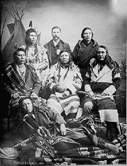
After the 1864 gold rush in newly established Montana Territory, pressure upon the Salish intensified from both illegal non-Indian squatters and government officials. In 1870, Victor died, and he was succeeded as chief by his son, Chief Charlo
Chief Charlo
Chief Charlo lived from 1830-1910 in the Bitterroot Valley and served as head chief of the Bitterroot Salish from 1870 to 1910. He was appointed chief upon death of his father, Chief Victor . Chief Victor was a principal signer of the Treaty of Hellgate in 1855...
t (aka Charlo, Claw of the Little Grizzly). Like his father, Charlot adhered to a policy of nonviolent resistance. He insisted on the right of his people to remain in the Bitterroot Valley. But territorial citizens and officials thought the new chief could be pressured into capitulating. In 1871, they successfully lobbied President Ulysses S. Grant
Ulysses S. Grant
Ulysses S. Grant was the 18th President of the United States as well as military commander during the Civil War and post-war Reconstruction periods. Under Grant's command, the Union Army defeated the Confederate military and ended the Confederate States of America...
to declare that the survey required by the treaty had been conducted and that it had found that the Jocko (Flathead) Reservation was better suited to the needs of the Salish. On the basis of Grant's executive order, Congress sent a delegation, led by future president James Garfield
James Garfield
James Abram Garfield served as the 20th President of the United States, after completing nine consecutive terms in the U.S. House of Representatives. Garfield's accomplishments as President included a controversial resurgence of Presidential authority above Senatorial courtesy in executive...
, to make arrangements with the tribe for their removal. Charlot ignored their demands and even their threats of bloodshed, and he again refused to sign any agreement to leave. U.S. officials then simply forged Charlot's X onto the official copy of the agreement that was sent to the Senate for ratification.
Over time, the real reason for the Hellgate treaty meetings became clear to the Salish and Pend d'Oreille people. Under the terms spelled out in the written document, the tribes ceded to the United States more than twenty million acres (81,000 km²) of land and reserved from cession about 1.3 million acres (5300 km²), thus forming the Jocko or Flathead Indian Reservation. Conditions had become intolerable for the Salish by the late 1880s, after the Missoula and Bitter Root Valley Railroad was constructed directly through the tribe's lands, with neither permission from the native owners nor payment to them. Charlot finally signed an agreement to leave the Bitterroot Valley in November 1889. Inaction by Congress, however, delayed the removal for another two years, and according to some observers, the tribe's desperation reached a level of outright starvation. In October 1891 a contingent of troops from Fort Missoula forced Charlot and the Salish out of the Bitterroot and roughly marched the small band sixty miles to the Flathead Reservation.
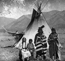
The three main tribes moved to the Flathead Reservation were the Bitteroot Salish, Pend d'Oreille, and Kootenai. The Bitterroot Salish and the Pend d'Oreille tribes spoke dialects of the same Salish language.
A dispute over off-reservation hunting between a band of Pend d'Oreilles and the state of Montana's Fish and Game department resulted in the Swan Valley Massacre of 1908
Swan Valley Massacre of 1908
The Swan Valley Massacre was an incident that occurred in 1908 in which hunting party of four Pend d'Oreilles Indians were killed by a state game warden and his deputy in the Swan Valley in Northwestern Montana...
.
Demographics
The tribe has about 6,800 members with approximately 4,000 tribal members currently living on the Flathead Reservation and 2,800 tribal members living off the reservation. Their predominant religion is Roman Catholic. 1,100 Native Americans from other tribes and over 10,000 non-Native Americans also live on the reservation.As the first to organize a tribal government under the Indian Reorganization Act of 1936, the tribes are governed by a tribal council. The Tribal Council has ten members and the council elects from within a Chairman, Vice Chairman, Secretary and Treasurer. The tribal government offers a number of services to tribal members and is the chief employer on the reservation. The tribes operate a tribal college, the Salish Kootenai College
Salish Kootenai College
Salish Kootenai College is a Native American tribal college based in Pablo, Montana which serves the Bitterroot Salish, Kootenai, and Pend d'Oreilles tribes. There are approximately 1,100 students attending the college; enrollment is not limited to Native American students.Prior to 1978, it was a...
, and a heritage museum called "The People's Center" in Pablo
Pablo, Montana
Pablo is a census-designated place in Lake County, Montana, United States. The population was 1,814 at the 2000 census. It is the seat of government of the Flathead Indian Reservation.-Geography:Pablo is located at ....
, seat of the tribal government.
The tribes own and jointly operate a valuable hydropower
Hydropower
Hydropower, hydraulic power, hydrokinetic power or water power is power that is derived from the force or energy of falling water, which may be harnessed for useful purposes. Since ancient times, hydropower has been used for irrigation and the operation of various mechanical devices, such as...
dam
Dam
A dam is a barrier that impounds water or underground streams. Dams generally serve the primary purpose of retaining water, while other structures such as floodgates or levees are used to manage or prevent water flow into specific land regions. Hydropower and pumped-storage hydroelectricity are...
called Kerr Dam
Kerr Dam
Kerr Dam is concrete gravity-arch dam located at river mile 72 of the Flathead River, increasing the size of Flathead Lake near Polson, Montana. The dam was designed for hydroelectricity but also serves recreational uses...
as well as the Best Western KwaTaqNuk Inn in Polson
Polson, Montana
Polson is a city in Lake County, Montana, United States, on the southern shore of Flathead Lake. It is also on the Flathead Indian Reservation. The population was 4,041 at the 2000 census. It is the county seat of Lake County...
, county seat
County seat
A county seat is an administrative center, or seat of government, for a county or civil parish. The term is primarily used in the United States....
of Lake County
Lake County, Montana
-National protected areas:*Flathead National Forest *National Bison Range *Ninepipe National Wildlife Refuge*Pablo National Wildlife Refuge*Swan River National Wildlife Refuge-Demographics:...
and most populous community on the reservation.
Aboriginal Lands
The peoples of these tribes originally lived in the areas of Montana, parts of IdahoIdaho
Idaho is a state in the Rocky Mountain area of the United States. The state's largest city and capital is Boise. Residents are called "Idahoans". Idaho was admitted to the Union on July 3, 1890, as the 43rd state....
, British Columbia
British Columbia
British Columbia is the westernmost of Canada's provinces and is known for its natural beauty, as reflected in its Latin motto, Splendor sine occasu . Its name was chosen by Queen Victoria in 1858...
and Wyoming
Wyoming
Wyoming is a state in the mountain region of the Western United States. The western two thirds of the state is covered mostly with the mountain ranges and rangelands in the foothills of the Eastern Rocky Mountains, while the eastern third of the state is high elevation prairie known as the High...
. The original territory comprised about 22 million acres (89,000 km²) at the time of the 1855 Hellgate Treaty
Treaty of Hellgate
The Treaty of Hellgate was signed in Hellgate on July 16, 1855 between Indian commissioner Isaac Stevens and the Native American tribes located in western Montana. The treaty was ratified by Congress, signed by President James Buchanan, and proclaimed on April 18, 1859.The tribes involved in the...
.

Reservation lands
The Flathead ReservationFlathead Indian Reservation
The Flathead Indian Reservation, located in western Montana on the Flathead River, is home to the Bitterroot Salish, Kootenai, and Pend d'Oreilles Tribes - also known as theConfederated Salish and Kootenai Tribes of the Flathead Nation...
in northwest Montana
Montana
Montana is a state in the Western United States. The western third of Montana contains numerous mountain ranges. Smaller, "island ranges" are found in the central third of the state, for a total of 77 named ranges of the Rocky Mountains. This geographical fact is reflected in the state's name,...
is over 1.3 million acres (5,300 km²) in size.
The Tribal Council represents eight districts:
- ArleeArlee, MontanaArlee is a census-designated place in Lake County, Montana, United States. The population was 602 at the 2000 census. It is named after Arlee, a Flathead Indian chief.-Geography:Arlee is located at ....
District - DixonDixon, MontanaDixon is a census-designated place in Sanders County, Montana, United States. The population was 216 at the 2000 census.-Geography:Dixon is located at ....
District - ElmoElmo, MontanaElmo is a census-designated place in Lake County, Montana, United States. The population was 143 at the 2000 census.-Geography:Elmo is located at ....
District - Hot SpringsHot Springs, MontanaHot Springs is a town on the Flathead Indian Reservation in Sanders County, Montana, United States. The population was 531 at the 2000 census. Founded in 1910, it was incorporated in 1929.-Geography:Hot Springs is located at ....
District - PabloPablo, MontanaPablo is a census-designated place in Lake County, Montana, United States. The population was 1,814 at the 2000 census. It is the seat of government of the Flathead Indian Reservation.-Geography:Pablo is located at ....
District - PolsonPolson, MontanaPolson is a city in Lake County, Montana, United States, on the southern shore of Flathead Lake. It is also on the Flathead Indian Reservation. The population was 4,041 at the 2000 census. It is the county seat of Lake County...
District - RonanRonan, MontanaRonan is a city in Lake County, Montana, United States. It lies on the Flathead Indian Reservation about 12 miles south of Flathead Lake in the northwestern part of the state...
District - St. IgnatiusSt. Ignatius, MontanaSt. Ignatius is a town in Lake County, Montana, United States. The population was 788 at the 2000 census. The town is located on the Flathead Indian Reservation.-Geography:St...
District
During World War II, a 422 feet (128.6 m) Liberty Ship, the SS Chief Charlot, was named in his honor and built in Richmond, CA in 1943.
Culture
- Languages
- Salish languageSalishan languagesThe Salishan languages are a group of languages of the Pacific Northwest...
- Kootenai language
- Salish language
- Historical Sites
- Archaeology
Notable people
- Corwin ClairmontCorwin ClairmontCorwin "Corky" Clairmont is a printmaker, conceptual and installation artist from the Confederated Salish and Kootenai Tribes of the Flathead Nation...
, artist and educator - Marvin CamelMarvin CamelMarvin Camel is a boxer and member of the Salish Kootenai Nation of the Flathead Indian Reservation in Northwestern Montana. He was born in Ronan and fought out of Missoula...
, boxer, WBC & IBF Cruiserweight Champion
External links
- Official site of the Confederated Tribes
- Official site of Nkwusm Salish Language Institute
- Treaty of Hellgate (1855)
- Lewis and Clark expedition journal entry
- http://curtis.library.northwestern.edu/curtis/viewPage.cgi?showp=1&size=2&id=nai.07.book.00000087&volume=7#nav Edward S. Curtis's The North American Indian, Northwestern University, Digital Library Collections, "Kalispel", Page 51