

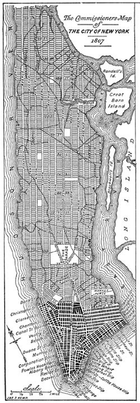
Commissioners' Plan of 1811
Encyclopedia
Manhattan
Manhattan is the oldest and the most densely populated of the five boroughs of New York City. Located primarily on the island of Manhattan at the mouth of the Hudson River, the boundaries of the borough are identical to those of New York County, an original county of the state of New York...
, which put in place the grid plan
Grid plan
The grid plan, grid street plan or gridiron plan is a type of city plan in which streets run at right angles to each other, forming a grid...
that has defined Manhattan to this day.
It originated as a proposal by the New York State Legislature
New York Legislature
The New York State Legislature is the term often used to refer to the two houses that act as the state legislature of the U.S. state of New York. The New York Constitution does not designate an official term for the two houses together...
, adopted in 1811 for the orderly development and sale of the land of Manhattan
Manhattan
Manhattan is the oldest and the most densely populated of the five boroughs of New York City. Located primarily on the island of Manhattan at the mouth of the Hudson River, the boundaries of the borough are identical to those of New York County, an original county of the state of New York...
between 14th Street
14th Street (Manhattan)
14th Street is a major crosstown street in the New York City borough of Manhattan. The street rivals the size of some of the well-known avenues of the city and is an important business location....
and Washington Heights
Washington Heights, Manhattan
Washington Heights is a New York City neighborhood in the northern reaches of the borough of Manhattan. It is named for Fort Washington, a fortification constructed at the highest point on Manhattan island by Continental Army troops during the American Revolutionary War, to defend the area from the...
. The plan is arguably the most famous use of the grid plan
Grid plan
The grid plan, grid street plan or gridiron plan is a type of city plan in which streets run at right angles to each other, forming a grid...
and is considered by most historians to have been far-reaching and visionary. Since its earliest days, the plan has been criticized for its monotony and rigidity, in comparison with irregular street patterns of older cities, but in recent years has been viewed more favorably by urban planning critics.
Central Park
Central Park
Central Park is a public park in the center of Manhattan in New York City, United States. The park initially opened in 1857, on of city-owned land. In 1858, Frederick Law Olmsted and Calvert Vaux won a design competition to improve and expand the park with a plan they entitled the Greensward Plan...
, the massive urban greenspace in Manhattan running from Eighth Avenue
Eighth Avenue (Manhattan)
Eighth Avenue is a north-south avenue on the West Side of Manhattan in New York City, carrying northbound traffic. Eighth Avenue begins in the West Village neighborhood at Abingdon Square and runs north for 44 blocks through Chelsea, the Garment District, Hell's Kitchen's east end, Midtown and the...
to Fifth Avenue
Fifth Avenue (Manhattan)
Fifth Avenue is a major thoroughfare in the center of the borough of Manhattan in New York City, New York, United States. The section of Fifth Avenue that crosses Midtown Manhattan, especially that between 49th Street and 60th Street, is lined with prestigious shops and is consistently ranked among...
and from 59th Street
59th Street (Manhattan)
59th Street in the New York City borough of Manhattan runs east-west, from York Avenue to the West Side Highway, with a discontinuity between Ninth Avenue/Columbus Avenue and Eighth Avenue/Central Park West for the Time Warner Center. Although it is bi-directional for most of its length, the...
to 110th Street
110th Street (Manhattan)
110th Street is a street in the New York City borough of Manhattan. It is commonly known as the boundary between Harlem and Central Park, along which it is known as Central Park North. In the west, it is also known as Cathedral Parkway....
, is not a part of this plan, as Central Park was not envisioned until 1853. There were a few smaller interruptions in the grid, such as a park called the Parade between 23rd Street
23rd Street (Manhattan)
23rd Street is a broad thoroughfare in the New York City borough of Manhattan. It is one of few two-way streets in the gridiron of the borough. As with Manhattan's other "crosstown" streets, it is divided at Fifth Avenue, in this case at Madison Square Park, into its east and west sections. Since...
and 33rd Street.
Origins
Earlier street layouts for Manhattan had been drawn up prior to the Commissioners' Plan. In 1797, for example, the city asked Joseph Mangin and Casimir Goerck to survey Manhattan's streets; the two eventually produced a map which included a web of future streets, most of which appeared to correspond with future developers' speculative plans for street grids on their properties north of the city. Nevertheless, the scheme was pointedly rejected by the City Council.In 1807, however, the City Council showed a new willingness to consider planning for the city's future, and asked the state for help in laying out future streets. The council said its goal was "laying out Streets... in such a manner as to unite regularity and order with the public convenience and benefit and in particular to promote the health of the City...." In March 1807, the council appointed a three-member commission made up of Gouverneur Morris
Gouverneur Morris
Gouverneur Morris , was an American statesman, a Founding Father of the United States, and a native of New York City who represented Pennsylvania in the Constitutional Convention of 1787. He was a signatory to the Articles of Confederation. Morris was also an author of large sections of the...
, the lawyer John Rutherfurd
John Rutherfurd
John Rutherfurd was an American politician and land surveyor.John Rutherfurd was born in New York City. His parents were Walter and Mary Rutherfurd. Walter was a veteran of the British Army, and was a hostage of Patriots during the Revolutionary War while John was a teenager. Walter died in 1804...
, and the surveyor Simeon De Witt
Simeon De Witt
Simeon De Witt was Geographer and Surveyor General of the Continental Army during the American Revolution and Surveyor General of the State of New York for the fifty years from 1784 until his death.-Life:He was one of fourteen children of physician Dr...
, to establish a comprehensive street plan for Manhattan.
A month later, the state legislature gave the commissioners "exclusive power to lay out streets, roads, and public squares, of such width, extent, and direction, as to them shall seem most conducive to public good, and to shut up, or direct to be shut up, any streets or parts thereof which have been heretofore laid out... [but] not accepted by the Common Council." The jurisdiction of the commission was all of Manhattan north of Houston Street, and into the Hudson and East Rivers 600 feet beyond the low water mark.
Morris was named the president of the commission. The commissioners were paid $4 a day for their work, and were empowered to enter onto private property, and were greeted with widespread hostility from property owners. The commissioners' chief engineer and surveyor, John Randel, Jr.
John Randel, Jr.
John Randel, Jr. was a surveyor from the United States who completed a full survey of Manhattan Island in over 10 years, starting in 1807. Simeon De Witt, one of the three commissioners charged with developing a plan for the future growth of New York, hired Randel to conduct a detailed survey of...
, said afterwards that he "was arrested by the Sheriff, on numerous suits instituted...for trespass and damage by...workmen, in passing over grounds, cutting off branches of trees. &c., to make surveys under instructions from the Commissioners."
The plan
The commissioners published their plan in March 1811 in the form of an eight-foot map with 12 main north-south avenues and numerous cross streets, with Broadway running at an angle through it. The goal was "a free and abundant circulation of air" to stave off disease. The right angles were also favored because "straight-sided and right-angled houses are the most cheap to build."The plan called for a regular grid of streets and property lines without regard to the topography
Topography
Topography is the study of Earth's surface shape and features or those ofplanets, moons, and asteroids...
of the island itself. The plan called for sixteen numbered and lettered avenues running north and south roughly parallel to the shore of the Hudson River
Hudson River
The Hudson is a river that flows from north to south through eastern New York. The highest official source is at Lake Tear of the Clouds, on the slopes of Mount Marcy in the Adirondack Mountains. The river itself officially begins in Henderson Lake in Newcomb, New York...
. Except in the north and south ends of the island, the avenues would begin with First Avenue on the east side and run through Twelfth Avenue in the west. In addition, in a neighborhood that would come to be known as the East Village
East Village, Manhattan
The East Village is a neighborhood in the borough of Manhattan in New York City, lying east of Greenwich Village, south of Gramercy and Stuyvesant Town, and north of the Lower East Side...
, nicknamed Alphabet City
Alphabet City, Manhattan
Alphabet City is a neighborhood located within the Lower East Side and East Village in the New York City borough of Manhattan. It is also known as Loisaida, a Spanglish adaptation of 'Lower East Side'. Its name comes from Avenues A, B, C, and D, the only avenues in Manhattan to have single-letter...
for obvious reasons, there would be four additional lettered avenues running from Avenue A
Avenue A (Manhattan)
Avenue A runs from north to south and is the westernmost of the avenues to be defined by letters instead of using the numbering system in the New York City borough of Manhattan. Avenue A runs from Houston Street to 14th Street, where it continues into a loop road in Stuyvesant Town, connecting to...
eastward to Avenue D
Avenue D (Manhattan)
Avenue D is the easternmost named avenue in the East Village neighborhood in the New York City borough of Manhattan, though several thoroughfares are closer to the East River. This area is also known as Alphabet City. Avenue D runs between East 12th Street and Houston Street, and continues south...
.
There would also be 155 orthogonal
Orthogonality
Orthogonality occurs when two things can vary independently, they are uncorrelated, or they are perpendicular.-Mathematics:In mathematics, two vectors are orthogonal if they are perpendicular, i.e., they form a right angle...
cross streets. The location of the cross streets was fixed at the boundaries of 5 acres (20,234.3 m²) parcels into which the land had previously been divided. The basepoint for the cross streets was First Street: this was a short and inconspicuous street, which still exists, and originally ran from the intersection of Avenue B and Houston Street to the intersection of the Bowery
Bowery, Manhattan
Bowery , commonly called "the Bowery," is a street and a small neighborhood in the southern portion of the New York City borough of Manhattan...
and Bleecker Street. Peretz Square
Peretz Square
Peretz Square is a public park in Lower Manhattan, New York City, which marks the spot where Houston Street, First Avenue, and First Street meet...
, a small triangular sliver park where Houston Street, First Street and First Avenue meet marks the spot where the grid takes hold.
Each avenue was to be one hundred feet (30 m) wide. The avenues in the center of the island were to be separated by 922 feet (281 m), and the avenues along the waterfront were to be slightly closer. The operating theory was that street frontage near the piers would be more valuable than the landlocked interior, the waterfront being the location of commerce and industry of the time, and so it would be to everyone's benefit to place avenues closer together at the island's edges.
The numbered streets running east-west are 60 feet (18.3 m) wide, with about 200 feet (61 m) between each pair of streets, resulting in a grid of approximately 2,000 long, narrow blocks. With each combined street and block adding up to about 260 feet (79.2 m), there are almost exactly 20 blocks per mile. Fifteen crosstown streets were designated as 100 feet (30.5 m) wide: 14th, 23rd, 34th, 42nd, 57th, 72nd, 79th, 86th, 96th, 106th, 116th, 125th, 135th, 145th and 155th Streets.
The width of the crosstown blocks was irregular. The distance between First and Second Avenues was 650 feet, but 610 feet was the gap between Second and Third Avenues, while the blocks between Third and Sixth Avenues were 920 feet, and 800 feet from Sixth to 12th. Lexington and Madison Avenues were added after the original plan.
Existing buildings could remain in place, and if removal was necessary the owners would receive compensation.
Extensions and modifications
The numbered street and avenue plan was eventually continued north of 155th Street155th Street (Manhattan)
155th Street is a major crosstown street in the Harlem neighborhood, in the New York City borough of Manhattan. It is the northernmost of the 155 crosstown streets mapped out in the Commissioner's Plan of 1811 that established the numbered street grid in Manhattan.155th Street starts on the West...
. It was also continued into the Bronx
The Bronx
The Bronx is the northernmost of the five boroughs of New York City. It is also known as Bronx County, the last of the 62 counties of New York State to be incorporated...
: however, the grids on the east side and west side do not match up exactly, especially in the northern reaches of the borough
Borough (New York City)
New York City, one of the largest cities in the world, is composed of five boroughs. Each borough now has the same boundaries as the county it is in. County governments were dissolved when the city consolidated in 1898, along with all city, town, and village governments within each county...
. The numbered cross streets are divided into East and West at Fifth Avenue
Fifth Avenue (Manhattan)
Fifth Avenue is a major thoroughfare in the center of the borough of Manhattan in New York City, New York, United States. The section of Fifth Avenue that crosses Midtown Manhattan, especially that between 49th Street and 60th Street, is lined with prestigious shops and is consistently ranked among...
in Manhattan north of Washington Square Park
Washington Square Park
Washington Square Park is one of the best-known of New York City's 1,900 public parks. At 9.75 acres , it is a landmark in the Manhattan neighborhood of Greenwich Village, as well as a meeting place and center for cultural activity...
and at Broadway
Broadway (New York City)
Broadway is a prominent avenue in New York City, United States, which runs through the full length of the borough of Manhattan and continues northward through the Bronx borough before terminating in Westchester County, New York. It is the oldest north–south main thoroughfare in the city, dating to...
south of the park (whose southern boundary is 4th Street).
Most of the numbered avenues have been officially renamed over part or all of their route: only First
First Avenue (Manhattan)
First Avenue is a north-south thoroughfare on the East Side of the New York City borough of Manhattan, running from Houston Street northbound for over 125 blocks before terminating at the Willis Avenue Bridge into The Bronx at the Harlem River near East 127th Street. South of Houston Street, the...
, Second
Second Avenue (Manhattan)
Second Avenue is an avenue on the East Side of the New York City borough of Manhattan extending from Houston Street at its south end to the Harlem River Drive at 128th Street at its north end. A one-way street, vehicular traffic runs only downtown. A bicycle lane in the left hand portion from 55th...
, Third
Third Avenue (Manhattan)
Third Avenue is a north-south thoroughfare on the East Side of the New York City borough of Manhattan, running from Cooper Square north for over 120 blocks. Third Avenue continues into The Bronx across the Harlem River over the Third Avenue Bridge north of East 129th Street to East Fordham Road at...
and Fifth Avenues
Fifth Avenue (Manhattan)
Fifth Avenue is a major thoroughfare in the center of the borough of Manhattan in New York City, New York, United States. The section of Fifth Avenue that crosses Midtown Manhattan, especially that between 49th Street and 60th Street, is lined with prestigious shops and is consistently ranked among...
have never been renamed, though some of the named avenues, such as Avenue of the Americas
Sixth Avenue (Manhattan)
Sixth Avenue – officially Avenue of the Americas, although this name is seldom used by New Yorkers – is a major thoroughfare in New York City's borough of Manhattan, on which traffic runs northbound, or "uptown"...
(Sixth), are also known by their numbers. Two additional avenues were interpolated amongst the original avenues: Madison Avenue
Madison Avenue (Manhattan)
Madison Avenue is a north-south avenue in the borough of Manhattan in New York City, United States, that carries northbound one-way traffic. It runs from Madison Square to the Madison Avenue Bridge at 138th Street. In doing so, it passes through Midtown, the Upper East Side , Spanish Harlem, and...
was built between Fifth Avenue
Fifth Avenue (Manhattan)
Fifth Avenue is a major thoroughfare in the center of the borough of Manhattan in New York City, New York, United States. The section of Fifth Avenue that crosses Midtown Manhattan, especially that between 49th Street and 60th Street, is lined with prestigious shops and is consistently ranked among...
and Park Avenue
Park Avenue (Manhattan)
Park Avenue is a wide boulevard that carries north and southbound traffic in New York City borough of Manhattan. Through most of its length, it runs parallel to Madison Avenue to the west and Lexington Avenue to the east....
(formerly Fourth Avenue), and Lexington Avenue
Lexington Avenue (Manhattan)
Lexington Avenue, often colloquially abbreviated by New Yorkers as "Lex," is an avenue on the East Side of the borough of Manhattan in New York City that carries southbound one-way traffic from East 131st Street to Gramercy Park at East 21st Street...
was built between Park Avenue
Park Avenue (Manhattan)
Park Avenue is a wide boulevard that carries north and southbound traffic in New York City borough of Manhattan. Through most of its length, it runs parallel to Madison Avenue to the west and Lexington Avenue to the east....
and Third Avenue
Third Avenue (Manhattan)
Third Avenue is a north-south thoroughfare on the East Side of the New York City borough of Manhattan, running from Cooper Square north for over 120 blocks. Third Avenue continues into The Bronx across the Harlem River over the Third Avenue Bridge north of East 129th Street to East Fordham Road at...
. Several other avenues were added to the grid when Upper Manhattan
Upper Manhattan
Upper Manhattan denotes the more northerly region of the New York City Borough of Manhattan. Its southern boundary may be defined anywhere between 59th Street and 155th Street. Between these two extremes lies the most common definitions of Upper Manhattan as Manhattan above 96th Street...
was developed, such as Riverside Drive
Riverside Drive (Manhattan)
Riverside Drive is a scenic north-south thoroughfare in the Manhattan borough of New York City. The boulevard runs on the west side of Manhattan, generally parallel to the Hudson River from 72nd Street to near the George Washington Bridge at 181st Street...
, Claremont Avenue
Claremont Avenue
Claremont Avenue is a relatively short street in the Manhattan borough of New York City, New York. It begins at 116th Street and runs north for a length of eleven blocks until Tiemann Place . The eastern side of Claremont Avenue features the heavily fortified backside of the Barnard College campus...
, and Saint Nicholas Avenue
Saint Nicholas Avenue (Manhattan)
Saint Nicholas Avenue is a major New York City street. It runs north-south between 193rd Street and 111th Streets in the New York City borough of Manhattan. It goes through the neighborhoods of Washington Heights, Harlem, Hamilton Heights, and Inwood...
. The old Bloomingdale Road (which is pictured on the original 1811 map) became part of what is now known as Broadway
Broadway (New York City)
Broadway is a prominent avenue in New York City, United States, which runs through the full length of the borough of Manhattan and continues northward through the Bronx borough before terminating in Westchester County, New York. It is the oldest north–south main thoroughfare in the city, dating to...
.
Over the years, portions of Avenue A were renamed Sutton Place in Midtown Manhattan, York Avenue in the Upper East Side, and Pleasant Avenue in East Harlem.
The plan of numbered crosstown streets has survived for two centuries with only minor variations and irregularities, especially below the original 155th Street northern boundary. The most notable irregularities are in Harlem
Harlem
Harlem is a neighborhood in the New York City borough of Manhattan, which since the 1920s has been a major African-American residential, cultural and business center. Originally a Dutch village, formally organized in 1658, it is named after the city of Haarlem in the Netherlands...
where West 125th
125th Street (Manhattan)
125th Street is a two-way street that runs east-west in the New York City borough of Manhattan, considered the "Main Street" of Harlem; It is also called Martin Luther King, Jr...
and West 126th Streets go off on a diagonal to the north, and in the West Village
West Village, Manhattan
The West Village is the western portion of the Greenwich Village neighborhood in the New York City borough of Manhattan. The area is usually defined as bounded by the Hudson River on the west and either Sixth Avenue or Seventh Avenue on the east, extending from 14th Street down to Houston Street...
where a number of streets vary from the original plan. Among them is West 4th Street
West 4th Street (Manhattan)
West Fourth Street runs east-west through most of eastern and central Manhattan and then turns north at Sixth Avenue to intersect with West 10th, 11th, 12th, and 13th Streets in Greenwich Village...
, intersecting with West 10th, 11th, 12th and 13th Streets.
In 1853, Central Park
Central Park
Central Park is a public park in the center of Manhattan in New York City, United States. The park initially opened in 1857, on of city-owned land. In 1858, Frederick Law Olmsted and Calvert Vaux won a design competition to improve and expand the park with a plan they entitled the Greensward Plan...
was laid out between 59th
59th Street (Manhattan)
59th Street in the New York City borough of Manhattan runs east-west, from York Avenue to the West Side Highway, with a discontinuity between Ninth Avenue/Columbus Avenue and Eighth Avenue/Central Park West for the Time Warner Center. Although it is bi-directional for most of its length, the...
and 110th Street
110th Street (Manhattan)
110th Street is a street in the New York City borough of Manhattan. It is commonly known as the boundary between Harlem and Central Park, along which it is known as Central Park North. In the west, it is also known as Cathedral Parkway....
s and Fifth Avenue
Fifth Avenue (Manhattan)
Fifth Avenue is a major thoroughfare in the center of the borough of Manhattan in New York City, New York, United States. The section of Fifth Avenue that crosses Midtown Manhattan, especially that between 49th Street and 60th Street, is lined with prestigious shops and is consistently ranked among...
and Eighth Avenue
Eighth Avenue (Manhattan)
Eighth Avenue is a north-south avenue on the West Side of Manhattan in New York City, carrying northbound traffic. Eighth Avenue begins in the West Village neighborhood at Abingdon Square and runs north for 44 blocks through Chelsea, the Garment District, Hell's Kitchen's east end, Midtown and the...
s. Other major interruptions of the 1811 plan include the main Columbia University
Columbia University
Columbia University in the City of New York is a private, Ivy League university in Manhattan, New York City. Columbia is the oldest institution of higher learning in the state of New York, the fifth oldest in the United States, and one of the country's nine Colonial Colleges founded before the...
campus
Campus
A campus is traditionally the land on which a college or university and related institutional buildings are situated. Usually a campus includes libraries, lecture halls, residence halls and park-like settings...
in Morningside Heights
Morningside Heights, Manhattan
Morningside Heights is a neighborhood of the Borough of Manhattan in New York City and is chiefly known as the home of institutions such as Columbia University, Teachers College, Barnard College, the Manhattan School of Music, Bank Street College of Education, the Cathedral of Saint John the...
, the Columbia University Medical Center
Columbia University Medical Center
Columbia University Medical Center is an academic medical center that includes Columbia University's College of Physicians and Surgeons, College of Dental Medicine, School of Nursing and Mailman School of Public Health...
campus in Washington Heights
Washington Heights, Manhattan
Washington Heights is a New York City neighborhood in the northern reaches of the borough of Manhattan. It is named for Fort Washington, a fortification constructed at the highest point on Manhattan island by Continental Army troops during the American Revolutionary War, to defend the area from the...
, Lincoln Center, Morningside Park, Stuyvesant Town
Stuyvesant Town
Stuyvesant Town—Peter Cooper Village is a large private residential development on the East Side of the borough of Manhattan in New York City, and one of the most iconic and successful post-World War II private housing communities...
, Peter Cooper Village, and the City College of New York
City College of New York
The City College of the City University of New York is a senior college of the City University of New York , in New York City. It is also the oldest of the City University's twenty-three institutions of higher learning...
.
Reaction to plan
The plan was vociferously criticized from the start, with one commentator in 1818 saying, "These are men who would have cut down the seven hills of Rome." Thomas Janvier's book In Old New York (1894) criticized the plan as only "a grind of money-making." More recently, the plan has come in for praise despite its shortcomings. One critic recently pointed out that the wide avenues attract retail and commercial use, among other benefits.See also
- Architecture in New York City
- City blockCity blockA city block, urban block or simply block is a central element of urban planning and urban design. A city block is the smallest area that is surrounded by streets. City blocks are the space for buildings within the street pattern of a city, they form the basic unit of a city's urban fabric...
- History of New York CityHistory of New York CityThe history of New York, New York begins with the first European documentation of the area by Giovanni da Verrazzano, in command of the French ship, La Dauphine, when he visited the region in 1524. It is believed he sailed in Upper New York Bay where he encountered native Lenape, returned through...
- ManhattanhengeManhattanhengeManhattanhenge – sometimes referred to as the Manhattan Solstice – is a semiannual occurrence in which the setting sun aligns with the east–west streets of the main street grid in the borough of Manhattan in New York City. The term is derived from Stonehenge, at which the sun aligns...
External links
- The Commissioners' report of 1807, with a modern introduction and an 1811 map
- Rose-Redwood, R. (2002), Rationalizing the Landscape: Superimposing the Grid upon the Island of Manhattan