
Colorado River Aqueduct
Encyclopedia
The Colorado River Aqueduct, or CRA, is a 242 mi (389.5 km) water conveyance in Southern California
in the United States
, operated by the Metropolitan Water District of Southern California
(MWD). The aqueduct impounds water from the Colorado River at Lake Havasu
on the California-Arizona
border west across the Mojave
and Colorado
deserts to the east side of the Santa Ana Mountains
. It is one of the primary sources of drinking water
for Southern California.
Originally conceived by William Mulholland
and designed by Chief Engineer Frank E. Weymouth of the MWD, it was the largest public works project in southern California during the Great Depression
. The project employed 30,000 people over an eight-year period and as many as 10,000 at one time.
The system is composed of two reservoirs, five pumping stations, 63 mi (101.4 km) of canals, 92 mi (148.1 km) of tunnels, and 84 mi (135.2 km) of buried conduit and siphons. Average annual throughput is 1200000 acre.ft.
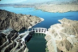
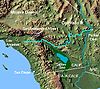 The Colorado River Aqueduct begins at Parker Dam
on the Colorado River
. There, the water is pumped up the Whipple Mountains
where the water emerges and begins flowing through 60 mi (96.6 km) of siphons and open canals on the southern Mojave Desert. At Iron Mountain
, the water is again lifted, 144 ft (43.9 m). the aqueduct then turns southwest towards the Eagle Mountains
. There the water is lifted two more times, first by 438 ft (133.5 m) to an elevation of more than 1400 ft (426.7 m), then by 441 ft (134.4 m) to an elevation of 1800 ft (548.6 m) above sea level. The CRA then runs through the deserts of the Coachella Valley
and through the San Gorgonio Pass. Near Cabazon, the aqueduct begins to run underground until it enters the San Jacinto Tunnel at the base of the San Jacinto Mountains
. On the other side of the mountains the aqueduct continues to run underground until it reaches the terminus at Lake Mathews
. From there, 156 mi (251.1 km) of distribution lines, along with eight more tunnels, delivers water to member cities. Some of the water is siphoned off in San Jacinto via the San Diego canal, part of the San Diego Aqueduct
that delivers water to San Diego County.
The MWD considered eight routes for the aqueduct. In 1931 the MWD board of directors choose the Parker route which would require the building of the Parker Dam. The Parker route was chosen because it was seen as the safest and most economical. A $220 million bond was approved on September 29, 1931. Work began in January 1933 near Thousand Palms, and in 1934 the United States Bureau of Reclamation began work on the Parker Dam. Construction of the aqueduct was finished in 1935. Water first flowed in the aqueduct on January 7, 1939.
The CRA contributed to urban growth (even sprawl) in the south coast region. Although the CRA brought "too much, too expensive" water in its early years of operation, subsidies (via property taxes) and expansion of MWD's service area brought reduced prices and expanded demand. (Holding supply constant, that meant that the quantity demanded rose to meet supplies.) On subsidies and sprawl, note that it was not until 1954 that Met's revenue from selling water exceed the cost of delivering it; it was not until 1973 that revenue from sales exceeded revenue from taxes. Since about 80 percent of Met's costs are fixed, revenue needs to cover far more than operating expenses if it is going to pay for all costs.
In 1955, the aqueduct was recognized by the American Society of Civil Engineers
(ASCE) as one of the "Seven Engineering Wonders of American Engineering".
On July 1, 1934, one of the tunnel crews narrowly escaped the tunnel as ground water had burst in and began filling up the tunnel and shafts at a rate of nearly 8000 USgal/min. MWD chief engineer F.E Weymouth had noted in his 1930 report on the tunnel routes that the Parker route “involves less risk than any of the other proposed lines.” The continued intrusion of water was too much for the original contractors working on the project to handle, and in February 1935 the MWD terminated the contract and took over the job. More pumps were brought in and a portion of the tunnel was re-routed. Three crews of 34 men, working eight hour shifts worked on the tunnel.
The MWD continued to encounter tunnel seepage. The amount varied but never dropped below 540 USgal/min, and sometimes topped 30000 USgal/min. By 1935 the seepage had started to become a concern around the San Jacinto Valley as springs, creeks and streams had begun to dry up. On October 21, 1935 the Riverside County Board of Supervisors passes a resolution calling on the MWD to prevent water from entering the tunnel or from flowing away from the place it was encountered. The MWD responded by
stating that water entering the tunnel during digging is nearly unavoidable, and that lining of the tunnels near the end of construction should prevent further inflow. Lawsuits were filed against MWD by nearby landowners and most of these were settled out of court, with MWD paying out over $350,000 between 1936 and 1944.
, across from Gilman Hot Springs, along with 3600 acres (14.6 km²) of grass and grazing in the upper Perris valley. The ranches were managed by Ed Poorman, known locally as the founding president of the Ramona Pageant Association. Ed Poorman's brother, Samuel Poorman was an attorney for the Los Angeles Department of Water and Power. In 1937, after noticing a drop in groundwater, Samuel Poorman negotiated a settlement with the MWD for the loss of groundwater, but instead of taking cash, the Poormans took their share in water.
The settlement was negotiated in secret and included two additional landowners. The Pico family, owners of a 3200 acres (12.9 km²) ranch southwest of the Poorman's ranch, also agreed to take water in return for dropping their claim against the MWD. Dairy farmer Clayton Record Sr. agreed to take five percent of the seepage water in exchange for right of way across his property. The contract was signed on February 11, 1937, turning over the entire seepage flow to the three ranchers, with 57 percent going to the Poormans. The pipeline that would carry water from the west portal crossed the Poorman ranch, and a safety blowout (where excess pressure could be released in an emergency) was built on the property where their share was delivered.
Other local ranchers and water companies were caught off guard by the settlement. The Nuevo Water Company had been negotiating with the MWD since 1936 to have the seepage water pumped higher up the San Jacinto River where it could be allowed to sink back into the natural water table. Nuevo thought it was close to a settlement when suddenly the MWD signed the Poorman contract and cut off all negotiations.
Slowly, as pressure built up over time, the tunnel grouting gave way and the seepage more than quadrupled. In February 1942, the Riverside County Board of Supervisors renewed its protest against exporting local water. The MWD responded by stating that local claims had been settled and that a substantial amount of the water was being used for local agriculture, indirectly citing the Poorman contract.
On June 21, 1944, the Water and Natural Resources Committee of the Hemet Valley Chamber of Commerce called a meeting of concerned ranchers from Hemet, San Jacinto, Perris, Lakeview and Nuevo. They organized themselves as the San Jacinto River Protective Committee, with Irwin Farrar elected as chairman. The committee focused on development of the local area, and claimed that water that was being carried out of the area by the MWD could irrigate up to 4000 acres (16.2 km²) each year. The committee made two demands of the
MWD; Stop seepage in the San Jacinto tunnel, and return the estimated 150000 acre.ft of water than had been carried away since 1934. Over $9000 was raised in local donations to help fight the battle with the MWD. On December 15, 1944, the committee met with the MWD Water Problems Committee and requested that water be pumped from the west portal further up the San Jacinto River and be released above the Soboba Indian Reservation where the water could spread out and sink back into the local water table. The MWD agreed to study the matter, however, by March 1945, the MWD had yet to respond.
The San Jacinto River Protective Committee arranged filings of four lawsuits against the MWD by various water users along the San Jacinto River. The four plaintiffs were the Nuevo Water Company, the Hemet Packing Company (owners of a 1000 acres (4 km²) ranch in Lakview), the Centinela Ranch near San Jacinto, and Leland Houk, who had a ranch southwest of Hemet. The MWD responded, maintaining that it had acted in good faith and claimed that 16400 acre.ft of water has been returned at the Cosa Loma outlet and Lakeview siphon, as agreed in the Poorman contract.
After further negotiations and meetings, the MWD agreed to attempt to seal the tunnel again. In December 1946, the tunnel was shut down and work was begun to remediate the leak. The tunnel was lined with concrete varying from 19 inches to 6 feet (1.8 m) in thickness. The seepage was temporarily reduced, but pressure again built up and the seepage then increased. By the end of 1947, the MWD and the San Jacinto River Conservation District (formerly the San Jacinto River Protective Committee) agreed that it was impossible to completely stop the seepage. By the fall of 1952, all the Poorman rights were acquired by the newly formed Eastern Municipal Water District of Southern California
. Benefit of the seepage water was conveyed to EMWD customers in the form of district-wide credits against water rates.
Southern California
Southern California is a megaregion, or megapolitan area, in the southern area of the U.S. state of California. Large urban areas include Greater Los Angeles and Greater San Diego. The urban area stretches along the coast from Ventura through the Southland and Inland Empire to San Diego...
in the United States
United States
The United States of America is a federal constitutional republic comprising fifty states and a federal district...
, operated by the Metropolitan Water District of Southern California
Metropolitan Water District of Southern California
The Metropolitan Water District of Southern California is the largest supplier of treated water in the US. The name is usually shortened to the "Metropolitan Water District" or simply "MWD". It is a cooperative of 14 cities and 12 municipal water districts that indirectly provides water to 18...
(MWD). The aqueduct impounds water from the Colorado River at Lake Havasu
Lake Havasu
Lake Havasu is a large reservoir behind Parker Dam on the Colorado River, on the border between California and Arizona. Lake Havasu City sits on the lake's eastern shore. The lake has a capacity of . The concrete arch dam was built by the United States Bureau of Reclamation between 1934 and 1938...
on the California-Arizona
Arizona
Arizona ; is a state located in the southwestern region of the United States. It is also part of the western United States and the mountain west. The capital and largest city is Phoenix...
border west across the Mojave
Mojave Desert
The Mojave Desert occupies a significant portion of southeastern California and smaller parts of central California, southern Nevada, southwestern Utah and northwestern Arizona, in the United States...
and Colorado
Colorado Desert
California's Colorado Desert is a part of the larger Sonoran Desert, which extends across southwest North America. The Colorado Desert region encompasses approximately , reaching from the Mexican border in the south to the higher-elevation Mojave Desert in the north and from the Colorado River in...
deserts to the east side of the Santa Ana Mountains
Santa Ana Mountains
The Santa Ana Mountains are a short peninsular mountain range along the coast of Southern California in the United States. They extend for approximately 36 mi southeast of the Los Angeles Basin largely along the border between Orange and Riverside counties.- Geography :The range starts in the...
. It is one of the primary sources of drinking water
Drinking water
Drinking water or potable water is water pure enough to be consumed or used with low risk of immediate or long term harm. In most developed countries, the water supplied to households, commerce and industry is all of drinking water standard, even though only a very small proportion is actually...
for Southern California.
Originally conceived by William Mulholland
William Mulholland
William Mulholland was the head of Los Angeles Department of Water and Power, in Los Angeles. He was responsible for building the water aqueducts and dams that allowed the city to grow into one of the largest in the world. His methods of obtaining water for the city led to disputes collectively...
and designed by Chief Engineer Frank E. Weymouth of the MWD, it was the largest public works project in southern California during the Great Depression
Great Depression
The Great Depression was a severe worldwide economic depression in the decade preceding World War II. The timing of the Great Depression varied across nations, but in most countries it started in about 1929 and lasted until the late 1930s or early 1940s...
. The project employed 30,000 people over an eight-year period and as many as 10,000 at one time.
The system is composed of two reservoirs, five pumping stations, 63 mi (101.4 km) of canals, 92 mi (148.1 km) of tunnels, and 84 mi (135.2 km) of buried conduit and siphons. Average annual throughput is 1200000 acre.ft.
Route
Parker Dam
Parker Dam is a concrete arch-gravity dam that crosses the Colorado River downstream of Hoover Dam. Built between 1934 and 1938 by the Bureau of Reclamation, it is high, of which are below the riverbed, making it "the deepest dam in the world". The dam's primary functions are to create a...
on the Colorado River
Colorado River
The Colorado River , is a river in the Southwestern United States and northwestern Mexico, approximately long, draining a part of the arid regions on the western slope of the Rocky Mountains. The watershed of the Colorado River covers in parts of seven U.S. states and two Mexican states...
. There, the water is pumped up the Whipple Mountains
Whipple Mountains
The Whipple Mountains, 'Avii Kur'utat in the Mojave language, are located in eastern San Bernardino County, California. They are directly west of the Colorado River, Parker Dam, and Lake Havasu; south of Needles, California; north of Parker, Arizona and Vidal, California; and northeast of Vidal...
where the water emerges and begins flowing through 60 mi (96.6 km) of siphons and open canals on the southern Mojave Desert. At Iron Mountain
Iron Mountain
-United States:Communities* Iron Mountain, Shasta County, California* Iron Mountain, Michigan, a city* Iron Mountain, Missouri, a community and historic mining area in St...
, the water is again lifted, 144 ft (43.9 m). the aqueduct then turns southwest towards the Eagle Mountains
Eagle Mountains
The Eagle Mountains are located in northeastern Riverside County, California, U.S.-Geography:The range lies to the north of Interstate 10 off Riverside County Route R2 and west— and southwest of the Coxcomb Mountains...
. There the water is lifted two more times, first by 438 ft (133.5 m) to an elevation of more than 1400 ft (426.7 m), then by 441 ft (134.4 m) to an elevation of 1800 ft (548.6 m) above sea level. The CRA then runs through the deserts of the Coachella Valley
Coachella Valley
Coachella Valley is a large valley landform in Southern California. The valley extends for approximately 45 miles in Riverside County southeast from the San Bernardino Mountains to the saltwater Salton Sea, the largest lake in California...
and through the San Gorgonio Pass. Near Cabazon, the aqueduct begins to run underground until it enters the San Jacinto Tunnel at the base of the San Jacinto Mountains
San Jacinto Mountains
The San Jacinto Mountains are a mountain range east of Los Angeles in southern California in the United States. The mountains are named for Saint Hyacinth . The Pacific Crest Trail runs along the spine of the range.The range extends for approximately from the San Bernardino Mountains southeast to...
. On the other side of the mountains the aqueduct continues to run underground until it reaches the terminus at Lake Mathews
Lake Mathews
Lake Mathews is a large reservoir in Riverside County, California, located in the foothills of the Santa Ana Mountains. It is the western terminus for the Colorado River Aqueduct that provides much of the water used by the cities and water districts of the Metropolitan Water District of Southern...
. From there, 156 mi (251.1 km) of distribution lines, along with eight more tunnels, delivers water to member cities. Some of the water is siphoned off in San Jacinto via the San Diego canal, part of the San Diego Aqueduct
San Diego Aqueduct
The San Diego Project, more popularly referenced as the San Diego Aqueduct, is a system of four aqueducts in the U.S. state of California, supplying about 90 percent of the water supply for the city of San Diego. The system comprises the First and Second San Diego Aqueducts, carrying water from the...
that delivers water to San Diego County.
Background and Construction
As the Los Angeles area grew in the early 1900s, Mulholland and others began looking for new sources of water. Eventually, Los Angeles laid claim to the waters of the Owens Valley, east of the Sierra Nevada, and in 1913 completed a 240 miles (386.2 km) aqueduct to deliver its waters to the burgeoning city. By 1923, Mulholland and his compatriots were looking east to an even larger water supply, the Colorado River. The plan was to dam the Colorado River and carry its waters across hundreds of miles of mountains and deserts. In 1924 the first steps were taken to create a metropolitan water district, made up of various cities throughout southern California. The Metropolitan Water District ("Met") was incorporated on December 6, 1928, and in 1929 took over where Los Angeles had left off, planning for a Colorado River aqueduct.The MWD considered eight routes for the aqueduct. In 1931 the MWD board of directors choose the Parker route which would require the building of the Parker Dam. The Parker route was chosen because it was seen as the safest and most economical. A $220 million bond was approved on September 29, 1931. Work began in January 1933 near Thousand Palms, and in 1934 the United States Bureau of Reclamation began work on the Parker Dam. Construction of the aqueduct was finished in 1935. Water first flowed in the aqueduct on January 7, 1939.
The CRA contributed to urban growth (even sprawl) in the south coast region. Although the CRA brought "too much, too expensive" water in its early years of operation, subsidies (via property taxes) and expansion of MWD's service area brought reduced prices and expanded demand. (Holding supply constant, that meant that the quantity demanded rose to meet supplies.) On subsidies and sprawl, note that it was not until 1954 that Met's revenue from selling water exceed the cost of delivering it; it was not until 1973 that revenue from sales exceeded revenue from taxes. Since about 80 percent of Met's costs are fixed, revenue needs to cover far more than operating expenses if it is going to pay for all costs.
In 1955, the aqueduct was recognized by the American Society of Civil Engineers
American Society of Civil Engineers
The American Society of Civil Engineers is a professional body founded in 1852 to represent members of the civil engineering profession worldwide. It is the oldest national engineering society in the United States. ASCE's vision is to have engineers positioned as global leaders who strive toward...
(ASCE) as one of the "Seven Engineering Wonders of American Engineering".
The San Jacinto Tunnel
The San Jacinto tunnel is considered the key link in Colorado River Aqueduct system. The 13 mi (20.9 km) long,16 ft (4.9 m) diameter tunnel runs underneath the San Jacinto Mountains between Cabazon and Gilman Springs. The $23 million project started on April 8, 1933. Tunnel crews dug from four directions; the two main portals and two shafts.On July 1, 1934, one of the tunnel crews narrowly escaped the tunnel as ground water had burst in and began filling up the tunnel and shafts at a rate of nearly 8000 USgal/min. MWD chief engineer F.E Weymouth had noted in his 1930 report on the tunnel routes that the Parker route “involves less risk than any of the other proposed lines.” The continued intrusion of water was too much for the original contractors working on the project to handle, and in February 1935 the MWD terminated the contract and took over the job. More pumps were brought in and a portion of the tunnel was re-routed. Three crews of 34 men, working eight hour shifts worked on the tunnel.
The MWD continued to encounter tunnel seepage. The amount varied but never dropped below 540 USgal/min, and sometimes topped 30000 USgal/min. By 1935 the seepage had started to become a concern around the San Jacinto Valley as springs, creeks and streams had begun to dry up. On October 21, 1935 the Riverside County Board of Supervisors passes a resolution calling on the MWD to prevent water from entering the tunnel or from flowing away from the place it was encountered. The MWD responded by
stating that water entering the tunnel during digging is nearly unavoidable, and that lining of the tunnels near the end of construction should prevent further inflow. Lawsuits were filed against MWD by nearby landowners and most of these were settled out of court, with MWD paying out over $350,000 between 1936 and 1944.
The Poorman Contract
The largest and most controversial settlement was known as the Poorman contract. The Poorman family owned a 1700 acres (6.9 km²) dairy ranch on the south side of the San Jacinto RiverSan Jacinto River (California)
The San Jacinto River is a river in Riverside County, California. The river's headwaters are in San Bernardino National Forest, but the lower portion of the watershed is urban and agricultural land....
, across from Gilman Hot Springs, along with 3600 acres (14.6 km²) of grass and grazing in the upper Perris valley. The ranches were managed by Ed Poorman, known locally as the founding president of the Ramona Pageant Association. Ed Poorman's brother, Samuel Poorman was an attorney for the Los Angeles Department of Water and Power. In 1937, after noticing a drop in groundwater, Samuel Poorman negotiated a settlement with the MWD for the loss of groundwater, but instead of taking cash, the Poormans took their share in water.
The settlement was negotiated in secret and included two additional landowners. The Pico family, owners of a 3200 acres (12.9 km²) ranch southwest of the Poorman's ranch, also agreed to take water in return for dropping their claim against the MWD. Dairy farmer Clayton Record Sr. agreed to take five percent of the seepage water in exchange for right of way across his property. The contract was signed on February 11, 1937, turning over the entire seepage flow to the three ranchers, with 57 percent going to the Poormans. The pipeline that would carry water from the west portal crossed the Poorman ranch, and a safety blowout (where excess pressure could be released in an emergency) was built on the property where their share was delivered.
Other local ranchers and water companies were caught off guard by the settlement. The Nuevo Water Company had been negotiating with the MWD since 1936 to have the seepage water pumped higher up the San Jacinto River where it could be allowed to sink back into the natural water table. Nuevo thought it was close to a settlement when suddenly the MWD signed the Poorman contract and cut off all negotiations.
Seepage Continues
In November 1938, the two segments of the tunnel met under the mountain, no more than a few inches off. With the excavation completed, the tunnel was then grouted with concrete. This operation filled in cracks and crevices and reduced the tunnel to its finished size of 16 feet (4.9 m) tall and 16 feet (4.9 m) wide. About 24,100 tons of cement were used in the attempts to seal off the seepage, averaging about 20 sacks per foot of tunnel. But as leaks were sealed off, pressure would build and create a new leak elsewhere. Eventually the seepage was cut down to 540 USgal/min, and on October 14, 1939, the San Jacinto Tunnel was completed, well ahead of schedule.Slowly, as pressure built up over time, the tunnel grouting gave way and the seepage more than quadrupled. In February 1942, the Riverside County Board of Supervisors renewed its protest against exporting local water. The MWD responded by stating that local claims had been settled and that a substantial amount of the water was being used for local agriculture, indirectly citing the Poorman contract.
On June 21, 1944, the Water and Natural Resources Committee of the Hemet Valley Chamber of Commerce called a meeting of concerned ranchers from Hemet, San Jacinto, Perris, Lakeview and Nuevo. They organized themselves as the San Jacinto River Protective Committee, with Irwin Farrar elected as chairman. The committee focused on development of the local area, and claimed that water that was being carried out of the area by the MWD could irrigate up to 4000 acres (16.2 km²) each year. The committee made two demands of the
MWD; Stop seepage in the San Jacinto tunnel, and return the estimated 150000 acre.ft of water than had been carried away since 1934. Over $9000 was raised in local donations to help fight the battle with the MWD. On December 15, 1944, the committee met with the MWD Water Problems Committee and requested that water be pumped from the west portal further up the San Jacinto River and be released above the Soboba Indian Reservation where the water could spread out and sink back into the local water table. The MWD agreed to study the matter, however, by March 1945, the MWD had yet to respond.
The San Jacinto River Protective Committee arranged filings of four lawsuits against the MWD by various water users along the San Jacinto River. The four plaintiffs were the Nuevo Water Company, the Hemet Packing Company (owners of a 1000 acres (4 km²) ranch in Lakview), the Centinela Ranch near San Jacinto, and Leland Houk, who had a ranch southwest of Hemet. The MWD responded, maintaining that it had acted in good faith and claimed that 16400 acre.ft of water has been returned at the Cosa Loma outlet and Lakeview siphon, as agreed in the Poorman contract.
After further negotiations and meetings, the MWD agreed to attempt to seal the tunnel again. In December 1946, the tunnel was shut down and work was begun to remediate the leak. The tunnel was lined with concrete varying from 19 inches to 6 feet (1.8 m) in thickness. The seepage was temporarily reduced, but pressure again built up and the seepage then increased. By the end of 1947, the MWD and the San Jacinto River Conservation District (formerly the San Jacinto River Protective Committee) agreed that it was impossible to completely stop the seepage. By the fall of 1952, all the Poorman rights were acquired by the newly formed Eastern Municipal Water District of Southern California
Eastern Municipal Water District of Southern California
The Eastern Municipal Water District of Southern California was formed in 1950 to secure additional water for a lightly populated area of western Riverside County. In addition to water service, responsibilities now include sewage collection, water desalination and water recycling.EMWD also sells...
. Benefit of the seepage water was conveyed to EMWD customers in the form of district-wide credits against water rates.
External links
- Metropolitan Water District of Southern California official website
- The Colorado River Aqueduct at The Center for Land Use Interpretation
- The Los Angeles Aqueduct at the Los Angeles Department of Water and PowerLos Angeles Department of Water and PowerThe Los Angeles Department of Water and Power is the largest municipal utility in the United States, serving over four million residents. It was founded in 1902 to supply water and electricity to residents and businesses in Los Angeles and surrounding communities...