
Coalville, Utah
Encyclopedia
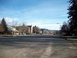
Coalville is a city in Summit County
, Utah
, United States
. It is part of the Salt Lake City
, Utah Metropolitan Statistical Area
. The population was 1,382 at the 2000 census. It is the county seat
of Summit County
. Interstate 80 runs through the town, as well as the Weber River
which runs into the Echo Reservoir just north of Coalville.
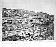 Coalville was founded in 1859 by William Henderson Smith, an early Mormon
freighter. He noticed that wheat spilled by other wagons moving through the area would grow to maturity. He subsequently convinced four families to settle in the area with him. The settlement was originally called Chalk Creek.
Early life in Chalk Creek was difficult, and during winters the settlers dealt with a constant scarcity of food. When food ran out, they would travel to Salt Lake City for supplies. The local Native Americans were also hostile for a time, and the settlers built a fort on advice of Brigham Young
.
In 1854 the territorial government in Utah offered a $1000 reward to anyone who could find coal within 40 miles of Salt Lake City. Four years later, Thomas Rhodes found a coal vein in the Chalk Creek area, and coal mining began in earnest. Hundreds of tons of coal were shipped to Salt Lake City, and soon a narrow gauge railroad was built. The settlement was renamed Coalville as a result of this early success mining coal.
 Coalville is located at 40°55′2"N 111°23′54"W (40.917231, -111.398385).
According to the United States Census Bureau
, the city has a total area of 3.3 mi2, of which 2.9 mi2 of it is land and 0.4 mi2 (12.27%) is water.
of 2000, there were 1,382 people, 465 households, and 371 families residing in the city. The population density
was 483.9 people per square mile (/km2). There were 495 housing units at an average density of 173.3 per square mile (/km2). The racial makeup of the city was 93.13% White, 0.07% African American, 0.80% Native American, 0.29% Asian, 0.07% Pacific Islander, 4.92% from other races
, and 0.72% from two or more races. Hispanic or Latino of any race were 6.87% of the population.
There were 465 households out of which 47.3% had children under the age of 18 living with them, 68.6% were married couples
living together, 8.0% had a female householder with no husband present, and 20.2% were non-families. 18.3% of all households were made up of individuals and 10.3% had someone living alone who was 65 years of age or older. The average household size was 2.97 and the average family size was 3.41.
In the city the population was spread out with 33.8% under the age of 18, 10.7% from 18 to 24, 28.9% from 25 to 44, 15.7% from 45 to 64, and 10.9% who were 65 years of age or older. The median age was 28 years. For every 100 females there were 104.7 males. For every 100 females age 18 and over, there were 103.3 males.
The median income for a household in the city was $39,342, and the median income for a family was $43,929. Males had a median income of $32,727 versus $20,833 for females. The per capita income
for the city was $17,830. About 5.9% of families and 8.0% of the population were below the poverty line, including 11.9% of those under age 18 and 6.2% of those age 65 or over.
, Middle School
, and Elementary School
. The North Summit High School's mascot is the Brave and the school colors are Purple and Gold. The Brave came from the large population of Shoshone
Indians that lived in the North Summit valley.
Locally small businesses serve the population. There are two primary grocery stores with small gas/grocery stores serving the peripheral areas. The primary source of local jobs come in the form of construction with local construction companies.
Summit County, Utah
Summit County is a county located in the U.S. state of Utah, occupying a rugged and mountainous area. In 2010 its population was 36,324. It is part of the Salt Lake City Metropolitan Statistical Area as well as the Salt Lake City–Ogden–Clearfield Combined Statistical Area. The county is...
, Utah
Utah
Utah is a state in the Western United States. It was the 45th state to join the Union, on January 4, 1896. Approximately 80% of Utah's 2,763,885 people live along the Wasatch Front, centering on Salt Lake City. This leaves vast expanses of the state nearly uninhabited, making the population the...
, United States
United States
The United States of America is a federal constitutional republic comprising fifty states and a federal district...
. It is part of the Salt Lake City
Salt Lake City, Utah
Salt Lake City is the capital and the most populous city of the U.S. state of Utah. The name of the city is often shortened to Salt Lake or SLC. With a population of 186,440 as of the 2010 Census, the city lies in the Salt Lake City metropolitan area, which has a total population of 1,124,197...
, Utah Metropolitan Statistical Area
Salt Lake City metropolitan area
The Salt Lake City Metropolitan Statistical Area, as defined by the United States Census Bureau, is an area consisting of three counties in north central Utah, anchored by Salt Lake City. As of the 2000 census, the MSA had a population of 968,858. As of July 1, 2009 the U.S...
. The population was 1,382 at the 2000 census. It is the county seat
County seat
A county seat is an administrative center, or seat of government, for a county or civil parish. The term is primarily used in the United States....
of Summit County
Summit County, Utah
Summit County is a county located in the U.S. state of Utah, occupying a rugged and mountainous area. In 2010 its population was 36,324. It is part of the Salt Lake City Metropolitan Statistical Area as well as the Salt Lake City–Ogden–Clearfield Combined Statistical Area. The county is...
. Interstate 80 runs through the town, as well as the Weber River
Weber River
The Weber River is a c. long river of northern Utah, USA. It begins in the northwest of the Uinta Mountains and empties into the Great Salt Lake. The Weber River was named for American fur trapper John Henry Weber.-Weber River:...
which runs into the Echo Reservoir just north of Coalville.
History
Mormon
The term Mormon most commonly denotes an adherent, practitioner, follower, or constituent of Mormonism, which is the largest branch of the Latter Day Saint movement in restorationist Christianity...
freighter. He noticed that wheat spilled by other wagons moving through the area would grow to maturity. He subsequently convinced four families to settle in the area with him. The settlement was originally called Chalk Creek.
Early life in Chalk Creek was difficult, and during winters the settlers dealt with a constant scarcity of food. When food ran out, they would travel to Salt Lake City for supplies. The local Native Americans were also hostile for a time, and the settlers built a fort on advice of Brigham Young
Brigham Young
Brigham Young was an American leader in the Latter Day Saint movement and a settler of the Western United States. He was the President of The Church of Jesus Christ of Latter-day Saints from 1847 until his death in 1877, he founded Salt Lake City, and he served as the first governor of the Utah...
.
In 1854 the territorial government in Utah offered a $1000 reward to anyone who could find coal within 40 miles of Salt Lake City. Four years later, Thomas Rhodes found a coal vein in the Chalk Creek area, and coal mining began in earnest. Hundreds of tons of coal were shipped to Salt Lake City, and soon a narrow gauge railroad was built. The settlement was renamed Coalville as a result of this early success mining coal.
Geography
According to the United States Census Bureau
United States Census Bureau
The United States Census Bureau is the government agency that is responsible for the United States Census. It also gathers other national demographic and economic data...
, the city has a total area of 3.3 mi2, of which 2.9 mi2 of it is land and 0.4 mi2 (12.27%) is water.
Demographics
As of the censusCensus
A census is the procedure of systematically acquiring and recording information about the members of a given population. It is a regularly occurring and official count of a particular population. The term is used mostly in connection with national population and housing censuses; other common...
of 2000, there were 1,382 people, 465 households, and 371 families residing in the city. The population density
Population density
Population density is a measurement of population per unit area or unit volume. It is frequently applied to living organisms, and particularly to humans...
was 483.9 people per square mile (/km2). There were 495 housing units at an average density of 173.3 per square mile (/km2). The racial makeup of the city was 93.13% White, 0.07% African American, 0.80% Native American, 0.29% Asian, 0.07% Pacific Islander, 4.92% from other races
Race (United States Census)
Race and ethnicity in the United States Census, as defined by the Federal Office of Management and Budget and the United States Census Bureau, are self-identification data items in which residents choose the race or races with which they most closely identify, and indicate whether or not they are...
, and 0.72% from two or more races. Hispanic or Latino of any race were 6.87% of the population.
There were 465 households out of which 47.3% had children under the age of 18 living with them, 68.6% were married couples
Marriage
Marriage is a social union or legal contract between people that creates kinship. It is an institution in which interpersonal relationships, usually intimate and sexual, are acknowledged in a variety of ways, depending on the culture or subculture in which it is found...
living together, 8.0% had a female householder with no husband present, and 20.2% were non-families. 18.3% of all households were made up of individuals and 10.3% had someone living alone who was 65 years of age or older. The average household size was 2.97 and the average family size was 3.41.
In the city the population was spread out with 33.8% under the age of 18, 10.7% from 18 to 24, 28.9% from 25 to 44, 15.7% from 45 to 64, and 10.9% who were 65 years of age or older. The median age was 28 years. For every 100 females there were 104.7 males. For every 100 females age 18 and over, there were 103.3 males.
The median income for a household in the city was $39,342, and the median income for a family was $43,929. Males had a median income of $32,727 versus $20,833 for females. The per capita income
Per capita income
Per capita income or income per person is a measure of mean income within an economic aggregate, such as a country or city. It is calculated by taking a measure of all sources of income in the aggregate and dividing it by the total population...
for the city was $17,830. About 5.9% of families and 8.0% of the population were below the poverty line, including 11.9% of those under age 18 and 6.2% of those age 65 or over.
Education
Coalville is home to North Summit School District which consists of North Summit High SchoolHigh school
High school is a term used in parts of the English speaking world to describe institutions which provide all or part of secondary education. The term is often incorporated into the name of such institutions....
, Middle School
Middle school
Middle School and Junior High School are levels of schooling between elementary and high schools. Most school systems use one term or the other, not both. The terms are not interchangeable...
, and Elementary School
Elementary school
An elementary school or primary school is an institution where children receive the first stage of compulsory education known as elementary or primary education. Elementary school is the preferred term in some countries, particularly those in North America, where the terms grade school and grammar...
. The North Summit High School's mascot is the Brave and the school colors are Purple and Gold. The Brave came from the large population of Shoshone
Shoshone
The Shoshone or Shoshoni are a Native American tribe in the United States with three large divisions: the Northern, the Western and the Eastern....
Indians that lived in the North Summit valley.
Economy
Most residents of the Coalville area pursue careers in farming, construction, small local business, or commute to the Wasatch Front. Primarily farmers in the area have raised cattle (beef and dairy cows), sheep, and mink. Farmers also raise a variety of crops such as alfalfa and wheat.Locally small businesses serve the population. There are two primary grocery stores with small gas/grocery stores serving the peripheral areas. The primary source of local jobs come in the form of construction with local construction companies.
See also
- Anthony GearyAnthony GearyAnthony Geary is an American actor. He has starred on the ABC daytime drama General Hospital as Luke Spencer from 1978 to 1984 and from 1993 to present.-Life and career:...
- Brant BoyerBrant BoyerBrant Boyer is a former American football linebacker who played ten seasons in the National Football League for three different teams. He was selected by the Jacksonville Jaguars in the 1995 NFL Expansion Draft. After five productive seasons with the Jaguars, Boyer spent three seasons as a member...
- Cove Fort, UtahCove Fort, UtahCove Fort is a fort and historical site located in Millard County, Utah. It was founded in 1867 by Ira Hinckley at the request of Brigham Young. One of its distinctive features is the use of volcanic rock in the construction of the walls, rather than the wood used in many mid-19th century...
- Interstate 80
- List of Registered Historic Places in Utah: Summit County
- U.S. Route 530