
Climate of the United Kingdom
Encyclopedia

United Kingdom
The United Kingdom of Great Britain and Northern IrelandIn the United Kingdom and Dependencies, other languages have been officially recognised as legitimate autochthonous languages under the European Charter for Regional or Minority Languages...
straddles the geographic mid-latitudes between 50-60 N from the equator. It is also positioned on the western seaboard of Eurasia, the world's largest land mass. These boundary conditions allow convergence between moist maritime air and dry continental air. In this area, the large temperature variation creates instability and this is a major factor that influences the often unsettled weather the country experiences, where many types of weather can be experienced in a single day.
Regional climates in the United Kingdom are influenced by the Atlantic Ocean and latitude.
Northern Ireland
Northern Ireland
Northern Ireland is one of the four countries of the United Kingdom. Situated in the north-east of the island of Ireland, it shares a border with the Republic of Ireland to the south and west...
, Wales
Wales
Wales is a country that is part of the United Kingdom and the island of Great Britain, bordered by England to its east and the Atlantic Ocean and Irish Sea to its west. It has a population of three million, and a total area of 20,779 km²...
and western parts of England
England
England is a country that is part of the United Kingdom. It shares land borders with Scotland to the north and Wales to the west; the Irish Sea is to the north west, the Celtic Sea to the south west, with the North Sea to the east and the English Channel to the south separating it from continental...
and Scotland
Scotland
Scotland is a country that is part of the United Kingdom. Occupying the northern third of the island of Great Britain, it shares a border with England to the south and is bounded by the North Sea to the east, the Atlantic Ocean to the north and west, and the North Channel and Irish Sea to the...
, being closest to the Atlantic, are generally the mildest, wettest and windiest regions of the UK, and temperature range
Temperature range
Atmospheric temperature range is the numerical difference between the minimum and maximum values of temperature observed in a given location....
s here are seldom extreme. Eastern areas are drier, cooler, less windy and also experience the greatest daily and seasonal temperature variations. Northern areas are generally cooler, wetter and have a slight bigger temperature range than southern areas. Though the UK is mostly under the influence of the maritime tropical air mass
Air mass
In meteorology, an air mass is a volume of air defined by its temperature and water vapor content. Air masses cover many hundreds or thousands of square miles, and adopt the characteristics of the surface below them. They are classified according to latitude and their continental or maritime...
from the south-west, different regions are more susceptible than others when different air masses affect the country: Northern Ireland and the west of Scotland are the most exposed to the maritime polar air mass which brings cool moist air; the east of Scotland and north-east England are more exposed to the continental polar air mass which brings cold dry air; the south and south-east of England are more exposed to the continental tropical air mass which brings warm dry air (and consequently most of the time the warmest summer temperatures); Wales and the south-west of England are the most exposed to the maritime tropical air mass which brings warm moist air. If the air masses are strong enough in their respective areas during the summer there can sometimes be a massive difference in temperature between the far north/north-west of Scotland (including the Islands) and south-east of England - usually around 10-15°C (18-27°F) but can be as much as 20°C (36°F) or more. An example of this could be that in the height of summer the northern isles could be sitting at around 15°C (59°F) and areas around London could be basking at 30°C (86°F)
England
England has warmer maximum and minimum temperatures throughout the year than the other areas of the UK, though Wales has milder minimums from November to February, and Northern Ireland has warmer maximums from December to February. England is also sunnier throughout the year, but unlike Wales, Northern Ireland and Scotland, the sunniest month is July, totaling 192.8 hours. It rains on fewer days in every month throughout the year than the rest of the UK, and rainfall totals are less in every month, with the driest month of July averaging 54.1 mm (2.1 in). The climate of south-west EnglandClimate of south-west England
The climate of south-west England is classed as oceanic according to the Köppen climate classification. The oceanic climate is typified by cool winters with warmer summers and precipitation all year round, with more experienced in winter. Annual rainfall is about and up to on higher ground...
experiences a seasonal temperature variation, although it is less extreme than most of the United Kingdom.
| England Weather Averages | ||||||||||||||
|---|---|---|---|---|---|---|---|---|---|---|---|---|---|---|
| Month | Jan | Feb | Mar | Apr | May | Jun | Jul | Aug | Sep | Oct | Nov | Dec | Year | |
| Average maximum temperature °C (°F) | 6.6 (43.9) |
6.9 (44.4) |
9.3 (48.7) |
11.7 (53.1) |
15.4 (59.7) |
18.1 (64.6) |
20.6 (69.1) |
20.5 (68.9) |
17.5 (63.5) |
13.6 (56.5) |
9.5 (49.1) |
7.4 (45.3) |
13.1 (55.6) |
|
| Average minimum temperature °C (°F) | 1.1 (34.0) |
1.0 (33.8) |
2.4 (36.3) |
3.6 (38.5) |
6.3 (43.3) |
9.1 (48.4) |
11.4 (52.5) |
11.2 (52.2) |
9.3 (48.7) |
6.6 (43.1) |
3.5 (38.3) |
2.0 (35.6) |
5.6 (42.1) |
|
| Sunshine hours |
50.5 | 67.7 | 102.5 | 145.2 | 189.9 | 179.4 | 192.8 | 184.1 | 135.0 | 101.3 | 65.2 | 43.9 | 1457.4 | |
| Rainfall mm (inches) |
84.2 (3.3) |
60.1 (2.4) |
66.5 (2.6) |
56.8 (2.2) |
55.9 (2.2) |
62.9 (2.5) |
54.1 (2.1) |
66.7 (2.6) |
73.3 (2.9) |
83.6 (3.3) |
83.5 (3.3) |
90.4 (3.6) |
838.0 (33.0) |
|
| Rainfall ≥ 1 mm days |
13.4 | 10.4 | 12.1 | 10.1 | 9.8 | 9.8 | 8.5 | 9.4 | 10.2 | 11.8 | 12.5 | 13.1 | 131.2 | |
| Source: Met Office (1971–2000 averages) | ||||||||||||||
Northern Ireland
Northern Ireland is warmer than Scotland throughout the year. Maximum temperatures are milder than in Wales from December to April, and milder than in England from December to February, but Northern Ireland is cooler during the rest of the year. Sunshine totals in every month are more than those of Scotland, but less than those of the rest of Great BritainGreat Britain
Great Britain or Britain is an island situated to the northwest of Continental Europe. It is the ninth largest island in the world, and the largest European island, as well as the largest of the British Isles...
. Northern Ireland is drier and has fewer rainy days than Scotland throughout the year, except in May, when it rains on more days. Northern Ireland is also drier than Wales in every month, yet it rains on more days. The rainiest month is January, when 17.8 days have more than 1 mm (0.0393700787401575 in) of rain on average.
| Northern Ireland Weather Averages | ||||||||||||||
|---|---|---|---|---|---|---|---|---|---|---|---|---|---|---|
| Month | Jan | Feb | Mar | Apr | May | Jun | Jul | Aug | Sep | Oct | Nov | Dec | Year | |
| Average maximum temperature °C (°F) | 6.7 (44.1) |
7.1 (44.8) |
8.9 (48.0) |
11.1 (52.0) |
14.2 (57.6) |
16.5 (61.7) |
18.4 (65.1) |
18.1 (64.6) |
15.7 (60.3) |
12.5 (54.5) |
9.2 (48.6) |
7.5 (45.5) |
12.2 (54.0) |
|
| Average minimum temperature °C (°F) | 1.2 (34.2) |
1.2 (34.2) |
2.3 (36.1) |
3.3 (37.9) |
5.6 (42.1) |
8.3 (46.9) |
10.6 (51.1) |
10.2 (50.4) |
8.3 (46.9) |
6.1 (43.0) |
3.1 (37.6) |
2.0 (35.6) |
5.2 (41.4) |
|
| Sunshine hours |
41.0 | 60.1 | 90.0 | 140.8 | 175.9 | 150.9 | 139.6 | 138.0 | 113.1 | 85.5 | 52.8 | 31.9 | 1219.7 | |
| Rainfall mm (inches) |
119.1 (4.7) |
86.5 (3.4) |
93.4 (3.7) |
70.6 (2.8) |
68.1 (2.7) |
72.1 (2.8) |
73.2 (2.9) |
90.8 (3.6) |
94.4 (3.7) |
114.5 (4.5) |
110.5 (4.4) |
118.5 (4.7) |
1111.6 (43.8) |
|
| Rainfall ≥ 1 mm days |
17.8 | 14.1 | 16.4 | 12.4 | 12.6 | 12.4 | 13.1 | 13.9 | 14.4 | 16.4 | 16.7 | 16.9 | 177.0 | |
| Source: Met Office (1971–2000 averages) | ||||||||||||||
Scotland
Scotland has the coolest weather of any country in the United Kingdom throughout the year (with the altitude climate varying into Cfc), with average minimum temperatures in January of -0.2 C. Scotland is also the wettest country in every month, apart from in May, June and December, when Wales is wetter. The wettest month is January, with 170.5 mm (6.7 in) on average. Scotland is also the cloudiest country throughout the year, apart from in June and July, when Northern Ireland is.| Scotland Weather Averages | ||||||||||||||
|---|---|---|---|---|---|---|---|---|---|---|---|---|---|---|
| Month | Jan | Feb | Mar | Apr | May | Jun | Jul | Aug | Sep | Oct | Nov | Dec | Year | |
| Average maximum temperature °C (°F) | 5.0 (41.0) |
5.2 (41.4) |
6.9 (44.4) |
9.3 (48.7) |
12.8 (55.0) |
14.9 (58.8) |
16.9 (62.4) |
16.6 (61.9) |
13.9 (57.0) |
10.8 (51.4) |
7.4 (45.3) |
5.7 (42.3) |
10.5 (50.9) |
|
| Average minimum temperature °C (°F) | -0.2 (31.6) |
-0.1 (31.8) |
0.9 (33.6) |
2.1 (35.8) |
4.5 (40.1) |
7.2 (45.0) |
9.3 (48.7) |
9.2 (48.6) |
7.2 (45.0) |
4.9 (40.8) |
2.0 (35.6) |
0.5 (32.9) |
4.0 (39.2) |
|
| Sunshine hours |
30.8 | 58.1 | 87.6 | 128.2 | 173.2 | 153.2 | 145.0 | 137.5 | 104.4 | 74.5 | 43.2 | 24.7 | 1160.4 | |
| Rainfall mm (inches) |
170.5 (6.7) |
123.4 (4.9) |
138.5 (5.5) |
86.2 (3.4) |
79.0 (3.1) |
85.1 (3.4) |
92.1 (3.6) |
107.4 (4.2) |
139.7 (5.5) |
162.6 (6.4) |
165.9 (6.5) |
169.6 (6.7) |
1520.1 (59.8) |
|
| Rainfall ≥ 1 mm days |
18.6 | 14.8 | 17.3 | 13.0 | 12.2 | 12.7 | 13.3 | 14.1 | 15.9 | 17.7 | 17.9 | 18.2 | 185.8 | |
| Source: Met Office (1971–2000 averages) | ||||||||||||||
Wales
Wales has warmer temperatures throughout the year than Scotland, and has milder winter minimums than England, but cooler winter maximums than Northern Ireland. Wales is wetter throughout the year than Northern Ireland and England, but has fewer rainy days than Northern Ireland; meaning that rainfall tends to be more intense. Wales is also drier than Scotland in every month apart from May, June and December, and there are fewer days with rain than in Scotland. Sunshine totals throughout the year are more than that of Scotland and Northern Ireland, but less than that of neighbouring England. May is the sunniest month, averaging 186.8 hours.| Wales Weather Averages | ||||||||||||||
|---|---|---|---|---|---|---|---|---|---|---|---|---|---|---|
| Month | Jan | Feb | Mar | Apr | May | Jun | Jul | Aug | Sep | Oct | Nov | Dec | Year | |
| Average maximum temperature °C (°F) | 6.5 (43.7) |
6.6 (43.9) |
8.6 (47.5) |
11.0 (51.8) |
14.5 (58.1) |
16.8 (62.2) |
19.1 (66.4) |
18.8 (65.8) |
16.2 (61.2) |
12.8 (55.0) |
9.3 (48.7) |
7.4 (45.3) |
12.3 (54.1) |
|
| Average minimum temperature °C (°F) | 1.3 (34.3) |
1.1 (34.0) |
2.4 (36.3) |
3.4 (38.1) |
6.0 (42.8) |
8.6 (47.5) |
10.9 (51.6) |
10.7 (51.3) |
8.8 (47.8) |
6.5 (43.7) |
3.7 (38.7) |
2.2 (36.0) |
5.5 (41.9) |
|
| Sunshine hours |
42.8 | 63.4 | 94.2 | 148.0 | 186.8 | 167.0 | 181.8 | 168.7 | 125.8 | 90.4 | 54.9 | 35.4 | 1359.3 | |
| Rainfall mm (inches) |
158.4 (6.2) |
113.8 (4.5) |
118.5 (4.7) |
85.7 (3.4) |
80.6 (3.2) |
86.0 (3.4) |
78.3 (3.1) |
105.8 (4.2) |
123.8 (4.9) |
152.9 (6.0) |
156.6 (6.2) |
173.1 (6.8) |
1433.5 (56.4) |
|
| Rainfall ≥ 1 mm days |
17.4 | 13.4 | 15.1 | 11.7 | 11.5 | 11.4 | 10.3 | 12.2 | 13.0 | 15.8 | 16.7 | 17.1 | 165.5 | |
| Source: Met Office (1971–2000 averages) | ||||||||||||||
Climate Averages for UK towns and cities
30 year averages (1971-2000 or 1961–1990) for UK towns and cities from the nearest Met Office and/or WMO compliant Weather Observation Stations.Northern Ireland
County Antrim- Climate of Antrim (Aldergrove)
- Climate of Ballycastle (Ballypatrick Forest)
County Armagh
- Climate of Armagh (Armagh Observatory)
County Down
- Climate of Belfast (Stormont)
- Climate of Lisburn (Hillsborough)
County Fermanagh
- Climate of Enniskillen (Lough Navar Forest)
County Londonderry
- Climate of Derry (Carmoney)
- Climate of Coleraine (Coleraine University)
Wales
- Climate of Aberystwyth (Gogerddan)
- Climate of Bala
- Climate of Barry (Rhoose)
- Climate of Cardiff (Bute Park)
- Climate of Cardigan (Aberporth)
- Climate of Cerrigydrudion (Alwen)
- Climate of Colwyn Bay
- Climate of Cwmystwyth
- Climate of Holyhead (Valley)
- Climate of Milford Haven
- Climate of Mold (Loggerheads)
- Climate of Neath
- Climate of Tenby
- Climate of Trawsgoed (Trawscoed)
Scotland
Aberdeen and Aberdeenshire- Climate of Aberdeen (Dyce & Craibstone)
- Climate of Ballater (Balmoral)
- Climate of Braemar
Angus and Dundee
- Climate of Dundee (Mylnefield)
Argyll and Bute
- Climate of Oban (Dunstaffnage)
- Climate of Cambeltown (Machrihanish)
- Climate of Oban (Dunstaffnage)
- Climate of Dunoon (Benmore Botanical Gardens)
- Climate of Rothesay, Isle of Bute
- Climate of Tiree
Ayrshire
- Climate of Ayr (Auchincruive)
- Climate of Prestwick
Borders
- Climate of Selkirk (Bowhill)
- Climate of West Linton (Blyth Bridge)
Dumfries and Galloway
- Climate of Eskdalemuir
- Climate of Dumfries
- Climate of St John's Town of Dalry (Glenlee)
- Climate of Castle Douglas (Threave)
Glasgow
- Climate of Glasgow (Abbotsinch & Paisley)
Highland
- Climate of Kinbrace
- Climate of Wick
- Climate of Cape Wrath
- Climate of Kinlochewe
- Climate of Poolewe
- Climate of Plockton
- Climate of Rum (Kinloch)
- Climate of Inverness
- Climate of Fort Augustus
- Climate of Onich
- Climate of Nairn
Lothian
- Climate of Penicuik
- Climate of Dunbar
- Climate of Edinburgh (RBG, Turnhouse & Gogarbank)
Lanarkshire
- Climate of Lanark (Carnwath)
- Climate of Leadhills
Moray
- Climate of Forres (Kinloss)
Northern Isles
- Climate of Baltasound
- Climate of Fair Isle
- Climate of Kirkwall
- Climate of Lerwick
Perth and Kinross
- Climate of Pitlochry (Faskally)
- Climate of Kenmore (Ardtalnaig)
- Climate of Perth
Western Isles
- Climate of Stornoway
- Climate of Balivanich (Benbecula)
England
Avon/Bristol- Climate of Bristol (Long Ashton & Bristol Weather Centre)
Bedfordshire
- Climate of Bedford (Bedford-Thurleigh)
- Climate of Luton (Rothamsted)
Berkshire
- Climate of Reading (Reading-Whiteknights)
- Climate of Slough (Heathrow)
Cambridgeshire
- Climate of Cambridge (Botanic Gardens & NIAB)
- Climate of Huntingdon (RAF Wyton)
Cheshire
- Climate of Chester (Hawarden)
Cornwall
- Climate of Helston (Culdrose)
- Climate of Bude (Bude)
- Climate of Newquay (St Mawgan)
Cumbria
- Climate of Carlisle
- Climate of Cockermouth (Aspatria)
- Climate of Coniston (Grizedale)
- Climate of Penrith (Newton Rigg)
Derbyshire
- Climate of Buxton
Devon
- Climate of Barnstaple (Chivenor)
- Climate of Plymouth (Mount Batten)
- Climate of Teignmouth (Teignmouth)
- Climate of Exeter (Exeter Airport)
- Climate of Dartmouth (Slapton)
- Climate of Dartmoor (Princeton)
Dorset
- Climate of Bournemouth (Hurn)
- Climate of Swanage
County Durham
- Climate of Durham
Essex
- Climate of Clacton
- Climate of Chelmsford (Writtle)
Gloucestershire
- Climate of Cheltenham
Greater London
- Climate of Central London (London Weather Centre)
- Climate of North London (Hampstead)
- Climate of South London (Greenwich)
Greater Manchester
- Climate of Manchester (Ringway)
Hampshire
- Climate of Southampton
- Climate of Hayling Island
- Climate of Andover (Leckford)
- Climate of Lymington (Everton)
Herefordshire
- Climate of Hereford (Preston Wynne)
- Climate of Kington (Lyonshall)
- Climate of Ross on Wye
Humberside
- Climate of Hull
Hertfordshire
- Climate of Bishops Stortford (Stansted)
Kent
- Climate of Ashford (Wye)
- Climate of Maidstone (East Malling)
- Climate of Royal Tunbridge Wells (Goudhurst)
Lancashire
- Climate of Blackpool
- Climate of Preston (Moor Park)
Leicestershire
- Climate of Leicester (Newtown Linford)
- Climate of Loughborough (Sutton Bonington)
Lincolnshire
- Climate of Cleethorpes
- Climate of Lincoln (Waddington)
- Climate of Skegness
- Climate of Sleaford (Cranwell)
Merseyside
- Climate of Liverpool (Bidston)
Norfolk
- Climate of Kings Lynn (Terrington St. Clement)
- Climate of Norwich (Coltishall)
- Climate of Swaffham (Marham)
Northamptonshire
- Climate of Corby (Caldecott)
- Climate of Northampton (Moulton Park)
Northumberland
- Climate of Kielder (Kielder Castle)
- Climate of Morpeth (Cockle Park)
- Climate of Amble (Boulmer)
Nottinghamshire
- Climate of Nottingham (Nottingham Watnall)
- Climate of Mansfield (Warsop)
Oxfordshire
- Climate of Oxford (Radcliffe observatory)
- Climate of Witney (Brize Norton)
- Climate of Wallingford (Wallingford/Benson)
Shropshire
- Climate of Shrewsbury (Shawbury)
Somerset
- Climate of Exmoor (Nettlecombe)
- Climate of Yeovil (Yeovilton)
Staffordshire
- Climate of Stoke on Trent (Keele)
- Climate of Stafford (Penkridge)
Suffolk
- Climate of Bury St Edmunds (Honington)
- Climate of Ipswich (East Bergholt)
- Climate of Lowestoft
- Climate of Stowmarket (Wattisham)
Surrey
- Climate of Farnham (Alice Holt Lodge)
- Climate of Guildford (Wisley)
Sussex
- Climate of Crawley (Gatwick)
- Climate of Eastbourne
- Climate of Hastings
- Climate of Bognor Regis
Tyne and Wear
- Climate of Newcastle (Newcastle Weather Centre)
Warwickshire
- Climate of Stratford upon Avon
- Climate of Warwick (Wellesbourne)
West Midlands
- Climate of Birmingham (Elmdon)
- Climate of Coventry (Coundon/Bablake)
- Climate of Halesowen
Wiltshire
- Climate of Salisbury (Boscombe Down)
- Climate of Swindon (Lyneham)
Worcestershire
- Climate of Malvern
Yorkshire
- Climate of Sheffield
- Climate of Malham (Malham Tarn)
- Climate of York (Askham Bryan)
- Climate of Malton (High Mowthorpe)
- Climate of Bingley (Bingley No.2)
- Climate of Bradford
- Climate of Northallerton (RAF Leeming)
- Climate of Whitby
Spring
Spring is the period from March to May. Spring is generally a calm, cool and dry season, particularly because the Atlantic has lost much of its heat throughout the autumn and winter. However, as the sun rises higher in the sky and the days get longer, temperatures can rise relatively high; thunderstormThunderstorm
A thunderstorm, also known as an electrical storm, a lightning storm, thundershower or simply a storm is a form of weather characterized by the presence of lightning and its acoustic effect on the Earth's atmosphere known as thunder. The meteorologically assigned cloud type associated with the...
s and heavy showers can develop occasionally.
There is a fair chance of snow earlier in the season when temperatures are colder. Some of the country's heaviest snowfalls of recent years have happened in the first half of March and snow showers can occur infrequently until mid-April.
Mean temperatures in Spring are markedly influenced by latitude. Most of Scotland and the mountains of Wales and northern England are the coolest areas of the UK, with average temperatures ranging from -0.6 C. The southern half of England experiences the warmest spring temperatures of between 8.8 and 10.3 °C (47.8 and 50.5 F).
Summer
Summer lasts from June to September and is the warmest season. Rainfall totals can have a wide local variation due to localised thunderstorms. These thunderstorms mainly occur in southern, eastern, and central England and are less frequent and severe in the north and west. North Atlantic depressions are not as severe in summer but increase both in severity and frequency towards the end of the season. Summer can see high pressure systems from the Azores HighAzores High
The Azores High is a large subtropical semi-permanent centre of high atmospheric pressure found near the Azores in the Atlantic Ocean, at the Horse latitudes...
.
Climatic differences at this time of year are more influenced by latitude and temperatures are highest in southern and central areas and lowest in the north. Generally, summer temperatures seldom go above 30 °C (86 °F), which happens more frequently in London and the South East than other parts of the country. Scotland and northern England have the coolest summers (average 12.2 °C (54 °F) to 14.8 °C (58.6 °F)), while Wales and the south-west of England have warmer summers (14.9 °C (58.8 °F) to 15.4 °C (59.7 °F)) and the south and south-east of England have the warmest summers (15.5 °C (59.9 °F) to 17.7 °C (63.9 °F)). The record maximum is 38.5 °C (101.3 °F) recorded in Faversham
Faversham
Faversham is a market town and civil parish in the Swale borough of Kent, England. The parish of Faversham grew up around an ancient sea port on Faversham Creek and was the birthplace of the explosives industry in England.-History:...
, Kent
Kent
Kent is a county in southeast England, and is one of the home counties. It borders East Sussex, Surrey and Greater London and has a defined boundary with Essex in the middle of the Thames Estuary. The ceremonial county boundaries of Kent include the shire county of Kent and the unitary borough of...
in August 2003—due to its proximity to the European land mass, the south-east usually experiences the highest summer temperatures in the United Kingdom.
Autumn
Autumn in the United Kingdom lasts from October to November. The season is notorious for being unsettled—as cool polar air moves southwards following the sun, it meets the warm air of the tropicsTropics
The tropics is a region of the Earth surrounding the Equator. It is limited in latitude by the Tropic of Cancer in the northern hemisphere at approximately N and the Tropic of Capricorn in the southern hemisphere at S; these latitudes correspond to the axial tilt of the Earth...
and produces an area of great disturbance along which the country lies. This combined with the warm ocean due to heating throughout the spring and summer, produces the unsettled weather of autumn. In addition, when the air is particularly cold temperatures on land may be colder than the ocean, resulting in significant amounts of condensation
Condensation
Condensation is the change of the physical state of matter from gaseous phase into liquid phase, and is the reverse of vaporization. When the transition happens from the gaseous phase into the solid phase directly, the change is called deposition....
and clouds which bring rain to the country.
Atlantic depressions during this time can become intense and winds of hurricane force (greater than 119 kilometre per hour) can be recorded. Western areas, being closest to the Atlantic, experience these severe conditions to a significantly greater extent than eastern areas. As such, autumn, particularly the latter part, is often the stormiest time of the year. One particularly intense depression was the Great Storm of 1987
Great Storm of 1987
The Great Storm of 1987 occurred on the night of 15/16 October 1987, when an unusually strong weather system caused winds to hit much of southern England and northern France...
.
However, the United Kingdom sometimes experiences an 'Indian Summer', where temperatures particularly by night can be very mild and rarely fall below 10 °C (50 °F). Such events are aided by the surrounding Atlantic Ocean and seas being at their warmest, keeping the country in warm air, despite the relatively weak sun. Examples of this were in 1985, 2005, 2006, and 2011
Autumn 2011 United Kingdom heat wave
The Autumn 2011 United Kingdom heat wave was a period of unseasonably hot weather which arrived towards the end of September 2011 and continued into October. As a result, record high temperatures for the country were broken for the autumn months...
where October even more so, saw above average temperatures which felt more like a continuation of summer than autumn. Autumns since 2000 have been very mild with notable extremes of precipitation; the UK has seen some of its wettest and driest autumns since the millennium.
Coastal areas in the southern half of England have on average the warmest autumns, with mean temperatures of 10.7 to 13 °C (51.3 to 55.4 F). Mountainous areas of Wales and northern England, and almost all of Scotland, experience mean temperatures between 1.7 and 7.5 °C (35.1 and 45.5 F).
Winter
Winter in the UK is defined as lasting from December to February. The season is generally cool, wet and windy. Temperatures at night rarely drop below -10 C and in the day rarely rise above 15 °C (59 °F). Precipitation is plentiful throughout the season, though snow is relatively infrequent despite the country's high latitude: The only areas with significant snowfall are the Scottish highlandsScottish Highlands
The Highlands is an historic region of Scotland. The area is sometimes referred to as the "Scottish Highlands". It was culturally distinguishable from the Lowlands from the later Middle Ages into the modern period, when Lowland Scots replaced Scottish Gaelic throughout most of the Lowlands...
and the Pennines
Pennines
The Pennines are a low-rising mountain range, separating the North West of England from Yorkshire and the North East.Often described as the "backbone of England", they form a more-or-less continuous range stretching from the Peak District in Derbyshire, around the northern and eastern edges of...
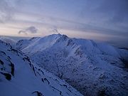
, where at higher elevations a colder climate determines the vegetation, mainly temperate coniferous forest, although deforestation has severely decreased forest area. For a majority of the landmass snow is possible but not frequent, apart from the higher altitudes, where snow can lie 1–5 months or even beyond 6 months.
Towards the later part of the season the weather usually stabilises with less wind, less precipitation and lower temperatures. This change is particularly pronounced near the coasts mainly because the Atlantic ocean
Atlantic Ocean
The Atlantic Ocean is the second-largest of the world's oceanic divisions. With a total area of about , it covers approximately 20% of the Earth's surface and about 26% of its water surface area...
is often at its coldest during this time after being cooled throughout the autumn and the winter. The early part of winter however is often unsettled and stormy; often the wettest and windiest time of the year.
Scotland
Scotland is a country that is part of the United Kingdom. Occupying the northern third of the island of Great Britain, it shares a border with England to the south and is bounded by the North Sea to the east, the Atlantic Ocean to the north and west, and the North Channel and Irish Sea to the...
where the amount of lying snow is frequently high enough to permit skiing
Skiing
Skiing is a recreational activity using skis as equipment for traveling over snow. Skis are used in conjunction with boots that connect to the ski with use of a binding....
at one of the five Scottish ski resorts. Snow however rarely lasts more than a week in most of these areas as the cold air brought by northerly or easterly winds, or in a high pressure system
High pressure area
A high-pressure area is a region where the atmospheric pressure at the surface of the planet is greater than its surrounding environment. Winds within high-pressure areas flow outward due to the higher density air near their center and friction with land...
gives way to mild southerly or westerly winds introduced by low pressure systems. However, on rare occasions some potent depressions may move in from the north in the form of 'polar low
Polar low
A polar low is a small-scale, long-lived atmospheric low pressure system that is found over the ocean areas poleward of the main polar front in both the Northern and Southern Hemispheres. The systems usually have a horizontal length scale of less than and exist for no more than a couple of days. ...
s', introducing heavy snow and often blizzard
Blizzard
A blizzard is a severe snowstorm characterized by strong winds. By definition, the difference between blizzard and a snowstorm is the strength of the wind. To be a blizzard, a snow storm must have winds in excess of with blowing or drifting snow which reduces visibility to 400 meters or ¼ mile or...
-like conditions to parts of the United Kingdom, particularly Scotland. During periods of light winds and high pressure frost
Frost
Frost is the solid deposition of water vapor from saturated air. It is formed when solid surfaces are cooled to below the dew point of the adjacent air as well as below the freezing point of water. Frost crystals' size differ depending on time and water vapour available. Frost is also usually...
and fog
Fog
Fog is a collection of water droplets or ice crystals suspended in the air at or near the Earth's surface. While fog is a type of stratus cloud, the term "fog" is typically distinguished from the more generic term "cloud" in that fog is low-lying, and the moisture in the fog is often generated...
can become a problem and can pose a major hazard for drivers on the roads.
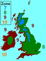
Mean winter temperatures in the UK are most influenced by proximity to the sea. The coldest areas are the mountains of Wales and northern England, and inland areas of Scotland, averaging -3.6 C. Coastal areas, particularly those in the south and west, experience the mildest winters, on average 5 to 8.7 °C (41 to 47.7 F). Hardiness zone
Hardiness zone
A hardiness zone is a geographically defined area in which a specific category of plant life is capable of growing, as defined by climatic conditions, including its ability to withstand the minimum temperatures of the zone...
s in the UK are high, ranging from zone 7 in the Scottish Highlands
Scottish Highlands
The Highlands is an historic region of Scotland. The area is sometimes referred to as the "Scottish Highlands". It was culturally distinguishable from the Lowlands from the later Middle Ages into the modern period, when Lowland Scots replaced Scottish Gaelic throughout most of the Lowlands...
, the Pennines
Pennines
The Pennines are a low-rising mountain range, separating the North West of England from Yorkshire and the North East.Often described as the "backbone of England", they form a more-or-less continuous range stretching from the Peak District in Derbyshire, around the northern and eastern edges of...
and Snowdonia
Snowdonia
Snowdonia is a region in north Wales and a national park of in area. It was the first to be designated of the three National Parks in Wales, in 1951.-Name and extent:...
, to zone 10 on the Isles of Scilly
Isles of Scilly
The Isles of Scilly form an archipelago off the southwestern tip of the Cornish peninsula of Great Britain. The islands have had a unitary authority council since 1890, and are separate from the Cornwall unitary authority, but some services are combined with Cornwall and the islands are still part...
. Most of the UK lies in zones 8 or 9. In zone 7, the average lowest temperature each year is between -17.7 C, and in zone 10, this figure is between -1.1 C.
Snow in the UK falls almost every year but in small quantities. The UK can suffer extreme winters like 1684, 1740, 1795 (when London received its record lowest temperature of -21.1 C), 1947 and 1963. In 1963 it snowed on Boxing Day in the UK and snow lasted in most areas until March 6 with blizzards through February. In modern times snow has become rarer but the UK can still get heavy falls. 1991
Winter of 1990–1991 in Western Europe
The winter of 1990–1991 was a particularly cold winter in Western Europe, noted especially for its effect on the United Kingdom, and for two significantly heavy falls of snow which occurred in December 1990 and February 1991. Sandwiched in between was a period of high winds and heavy rain which...
is very famous because of the extreme cold and powdery snow that fell, and 1979, 1981/82 and 1987 also had heavy snowfall. 1987 had very heavy Lake-effect snow which affected London and the South-East with snowfall in excess of 50 cm (19.7 in). In February 2009 snow fell very heavily in the South on the 2nd, there was 32 cm (12.6 in) of snow in Surrey
Surrey
Surrey is a county in the South East of England and is one of the Home Counties. The county borders Greater London, Kent, East Sussex, West Sussex, Hampshire and Berkshire. The historic county town is Guildford. Surrey County Council sits at Kingston upon Thames, although this has been part of...
, South of London. Also a notable heavy band affecting Mid-Sussex also on the 2nd dumping 26 cm (10.2 in) on the higher levels of Brighton
Brighton
Brighton is the major part of the city of Brighton and Hove in East Sussex, England on the south coast of Great Britain...
and the South Downs
South Downs
The South Downs is a range of chalk hills that extends for about across the south-eastern coastal counties of England from the Itchen Valley of Hampshire in the west to Beachy Head, near Eastbourne, East Sussex, in the east. It is bounded on its northern side by a steep escarpment, from whose...
. On the 6th another band of snow affected the south-west dumping 55 cm (21.7 in) in Okehampton
Okehampton
Okehampton is a town and civil parish in West Devon in the English county of Devon. It is situated at the northern edge of Dartmoor, and has an estimated population of 7,155.-History:...
, Devon. 2009 was officially the heaviest snowfall since 1991. See February 2009 Great Britain and Ireland snowfall
February 2009 Great Britain and Ireland snowfall
The snowfall across the British Isles in February 2009 was a prolonged period of snowfall that began on 1 February 2009. Some areas experienced their largest snowfall levels in 18 years. Snow fell over much of Western Europe. The United Kingdom's Met Office and Ireland's Met Éireann issued severe...
. Most snowfall comes from cold Easterly winds from Siberia - making the North and the East the coldest parts of Britain. The winter of 2009-10
Winter of 2009–2010 in Europe
The winter of 2009–2010 in Europe was unusually cold. Globally, atypical weather patterns brought cold, moist air from the north. Weather systems were undergoing cyclogenesis from North American storms moving across the Atlantic Ocean to the west, and saw many parts of Europe experiencing heavy...
was even more severe, with many parts of the United Kingdom experiencing the coldest and snowiest winters since 1981/82; temperatures plummeted to -22.3 °C at Altnaharra, Sutherland – close to the -22.9 °C recorded at the southernmost part of the globe at the same period. The record for the lowest temperature ever recorded in the UK still remains -27.2 °C which was recorded on January 10, 1982 in Braemar
Braemar
Braemar is a village in Aberdeenshire, Scotland, around west of Aberdeen in the Highlands. It is the closest significantly-sized settlement to the upper course of the River Dee sitting at an altitude of ....
, Scotland. December 2010 was the coldest December in 100 years, the CET (Central England Temperature) was -1.0C, meaning it was the coldest month since February 1986. Many places experienced heavy snowfall and extreme cold, temperatures regularly fell below -10.0 C) across many areas. However, the cold subsided after Christmas Day, 2010.
In the 1990s and 2000s, most of the winters were milder and usually wetter than average with daytime temperatures going below freezing a rare occurrence. In fact, the winter of 1995/1996 was the only one which was defined as below average in terms of the UK as a whole. The winters of 2008/09, 2009/10 and 2010/11 have however seen a different pattern with these three winters being defined as below or well below average with large snowfall amounts widespread and very low temperatures; this was the first time three consecutive cold winters in the UK have occurred since the 1960s.
Months
- January –
January is predominantly a cold month with little sunshine. Snow is possible throughout the month as are hard frosts. It is also often a stormy month, with rainfall likely to occur. However, on occasions some potent depressions may move in from the north in the form of 'Polar Lows', introducing heavy snow and often blizzard-like conditions to parts of the United Kingdom
United Kingdom
The United Kingdom of Great Britain and Northern IrelandIn the United Kingdom and Dependencies, other languages have been officially recognised as legitimate autochthonous languages under the European Charter for Regional or Minority Languages...
, particularly Scotland
Scotland
Scotland is a country that is part of the United Kingdom. Occupying the northern third of the island of Great Britain, it shares a border with England to the south and is bounded by the North Sea to the east, the Atlantic Ocean to the north and west, and the North Channel and Irish Sea to the...
. During periods of light winds and high pressure frost
Frost
Frost is the solid deposition of water vapor from saturated air. It is formed when solid surfaces are cooled to below the dew point of the adjacent air as well as below the freezing point of water. Frost crystals' size differ depending on time and water vapour available. Frost is also usually...
and fog
Fog
Fog is a collection of water droplets or ice crystals suspended in the air at or near the Earth's surface. While fog is a type of stratus cloud, the term "fog" is typically distinguished from the more generic term "cloud" in that fog is low-lying, and the moisture in the fog is often generated...
can also become a problem.
- February –
This month is nearing towards the end of Winter – however this can chiefly have some of the coldest temperatures over the whole season. The longer days bring very cold weather with overnight frosts. Bright and sunny days can also be possible, due to the frosts. Snow is also possible and many winters have experienced their heaviest snowfall in February.
- March –
This is the first month of Spring and although there is usually still a raw edge to the weather – sunny days in March can often be pleasantly warm. There is still a fair chance of snow earlier in the season when temperatures are colder. There is also a small chance that stormy weather can occur as the saying goes “March comes in like a lion
Lion
The lion is one of the four big cats in the genus Panthera, and a member of the family Felidae. With some males exceeding 250 kg in weight, it is the second-largest living cat after the tiger...
and goes out like a lamb”.
- April –
Spring is often well underway in April. In recent years, there have been long, warm and sunny days throughout the month. It is often settled and the old adage of ‘April showers’ is not often true to its worth. There is still a chance of snow in April – but it will be unlikely to last for long. Temperatures in the settled weather can sometimes reach the high teens or even early 20’s.
- May –
May is another often calm and dry month, as the sun rises higher in the sky and the days get longer, temperatures can rise relatively high; thunderstorms and heavy showers can develop occasionally. May has often been known to have minor heatwaves – reaching the high 20’s. Other years though, can sometimes produce very cool and wet weather. There may be still Wintry weather around in the early parts of May in the Scottish Highlands
Scottish Highlands
The Highlands is an historic region of Scotland. The area is sometimes referred to as the "Scottish Highlands". It was culturally distinguishable from the Lowlands from the later Middle Ages into the modern period, when Lowland Scots replaced Scottish Gaelic throughout most of the Lowlands...
.
- June –
June is the start of summer and has the longest days in the whole year. June can often be a dry and warm month – even hot – but heavy rainfall and thunderstorms can occur. Cool weather is also possible. Temperatures can vary from early teens to bordering on 30C.
- July –
July can often be a dry month, but rainfall totals can have a wide local variation due to localised thunderstorms. These thunderstorms mainly occur in southern, eastern, and central England and are less frequent and severe in the north and west. July often sees high pressure systems dominate – with potential heatwaves possible.
- August –
August will mostly continue in the same pattern as July, as it can still potentially be a hot month, with rainfall never too far away. This is the last month of summer and the evenings can potentially be rather warm and mild.
- September –
This is the first autumnal month, and the start of September can often be a continuation of summer – as is the case of recent years – this is called an ‘Indian Summer
Indian summer
An Indian summer is a meteorological phenomenon that occurs in the autumn. It refers to a period of considerably above normal temperatures, accompanied by dry and hazy conditions, usually after there has been a killing frost...
’. Temperatures by night can be very mild and rarely fall below 10 °C. Such events are aided by the surrounding Atlantic Ocean and seas being at their warmest, keeping the country in warm air. Although changeable the weather is often surprisingly good, but westerly gales can often be a feature of the month.
- October –
By October, there is usually a distinct chill in the air and many regions will have experienced their first frosty nights. This is generally an unsettled month with infrequent settled periods. Autumnal storms are likely and this can bring very wet and stormy weather with localised flooding in places. October can sometimes experience a small continuation of Summer, with temperatures reaching the 20’s, on the other hand, mountainous areas of Scotland and Northern England may see a return in Wintry weather.
- November –
November is often a very unsettled month with Atlantic depressions during this time becoming intense and winds of hurricane force can be recorded. Western areas, being closest to the Atlantic, experience these severe conditions to a significantly greater extent than eastern areas. As such, November is often the stormiest time of year. Novembers since 2000 have been very mild with notable extremes of precipitation. Although the weather is rather unpredictable, it is not unusual for many parts to experience a brief cold snap in November.
- December –
December is the first month of winter and has the shortest days of the whole year. The month can often experience very cold, bright and settled weather – with severe overnight frosts. This early part of winter can also sometimes be unsettled and stormy. Temperatures can typically reach sub zero throughout the month.
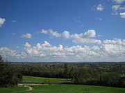
Sunshine and cloud
Cumulus cloud
Cumulus clouds are a type of cloud with noticeable vertical development and clearly defined edges. Cumulus means "heap" or "pile" in Latin. They are often described as "puffy" or "cotton-like" in appearance. Cumulus clouds may appear alone, in lines, or in clusters...
formation generally takes place over land, and prevailing winds from the south-west keep this cloud from forming overhead. The counties of Dorset
Dorset
Dorset , is a county in South West England on the English Channel coast. The county town is Dorchester which is situated in the south. The Hampshire towns of Bournemouth and Christchurch joined the county with the reorganisation of local government in 1974...
, Hampshire
Hampshire
Hampshire is a county on the southern coast of England in the United Kingdom. The county town of Hampshire is Winchester, a historic cathedral city that was once the capital of England. Hampshire is notable for housing the original birthplaces of the Royal Navy, British Army, and Royal Air Force...
, Sussex
Sussex
Sussex , from the Old English Sūþsēaxe , is an historic county in South East England corresponding roughly in area to the ancient Kingdom of Sussex. It is bounded on the north by Surrey, east by Kent, south by the English Channel, and west by Hampshire, and is divided for local government into West...
and Kent
Kent
Kent is a county in southeast England, and is one of the home counties. It borders East Sussex, Surrey and Greater London and has a defined boundary with Essex in the middle of the Thames Estuary. The ceremonial county boundaries of Kent include the shire county of Kent and the unitary borough of...
have annual average totals of around 1,750 hours of sunshine per year. Northern, western and mountain
Mountain
Image:Himalaya_annotated.jpg|thumb|right|The Himalayan mountain range with Mount Everestrect 58 14 160 49 Chomo Lonzorect 200 28 335 52 Makalurect 378 24 566 45 Mount Everestrect 188 581 920 656 Tibetan Plateaurect 250 406 340 427 Rong River...
ous areas are generally the cloudiest areas of the UK, with some mountainous areas receiving fewer than 1,000 hours of sunshine a year.
Valley areas such as the South Wales Valleys
South Wales Valleys
The South Wales Valleys are a number of industrialised valleys in South Wales, stretching from eastern Carmarthenshire in the west to western Monmouthshire in the east and from the Heads of the Valleys in the north to the lower-lying, pastoral country of the Vale of Glamorgan and the coastal plain...
, due to their north-south orientation, receive less sunshine than lowland areas because the mountains on either side of the valley obscure the sun in the early morning and late evening. This is noticeable in winter where there are only a few hours of sunshine. The mountains of Wales, northern England and Scotland can be especially cloudy with extensive mist
Mist
Mist is a phenomenon of small droplets suspended in air. It can occur as part of natural weather or volcanic activity, and is common in cold air above warmer water, in exhaled air in the cold, and in a steam room of a sauna. It can also be created artificially with aerosol canisters if the...
and fog
Fog
Fog is a collection of water droplets or ice crystals suspended in the air at or near the Earth's surface. While fog is a type of stratus cloud, the term "fog" is typically distinguished from the more generic term "cloud" in that fog is low-lying, and the moisture in the fog is often generated...
. Near the coast, sea fog may develop in the spring and early summer. Radiation fog may develop over inland areas of Great Britain
Great Britain
Great Britain or Britain is an island situated to the northwest of Continental Europe. It is the ninth largest island in the world, and the largest European island, as well as the largest of the British Isles...
and can persist for hours or even days in the winter and can pose a major hazard for drivers and aircraft.
On occasions blocking anticyclones (high pressure systems
High pressure area
A high-pressure area is a region where the atmospheric pressure at the surface of the planet is greater than its surrounding environment. Winds within high-pressure areas flow outward due to the higher density air near their center and friction with land...
) may move over the United Kingdom, which can persist for weeks or even months. The subsided, dry air often results in clear skies and few clouds, bringing frost
Frost
Frost is the solid deposition of water vapor from saturated air. It is formed when solid surfaces are cooled to below the dew point of the adjacent air as well as below the freezing point of water. Frost crystals' size differ depending on time and water vapour available. Frost is also usually...
y nights in winter and hot days in the summer, when some coastal areas can achieve almost maximum possible sunshine for periods of weeks.
Average hours of sunshine in winter range from 38–108 hours in some mountainous areas and western Scotland, up to 217 hours in the south and east of England; while average hours of sunshine in summer range from 294–420 hours in northern Scotland and Northern Ireland, to 592–726 hours in southern English coastal counties.
The most sunshine recorded in one month was 383.9 hours at Eastbourne
Eastbourne
Eastbourne is a large town and borough in East Sussex, on the south coast of England between Brighton and Hastings. The town is situated at the eastern end of the chalk South Downs alongside the high cliff at Beachy Head...
(East Sussex
East Sussex
East Sussex is a county in South East England. It is bordered by the counties of Kent, Surrey and West Sussex, and to the south by the English Channel.-History:...
) in July 1911.
The Atlantic Ocean
One of the greatest influences on the climate of the UK is the Atlantic Ocean and especially the North Atlantic CurrentNorth Atlantic Current
The North Atlantic Current is a powerful warm ocean current that continues the Gulf Stream northeast. West of Ireland it splits in two; one branch, the Canary Current, goes south, while the other continues north along the coast of northwestern Europe...
, which brings warm waters from the Gulf of Mexico
Gulf of Mexico
The Gulf of Mexico is a partially landlocked ocean basin largely surrounded by the North American continent and the island of Cuba. It is bounded on the northeast, north and northwest by the Gulf Coast of the United States, on the southwest and south by Mexico, and on the southeast by Cuba. In...
to the waters around the country by means of thermohaline circulation
Thermohaline circulation
The term thermohaline circulation refers to a part of the large-scale ocean circulation that is driven by global density gradients created by surface heat and freshwater fluxes....
. This has a powerful moderating and warming effect on the country's climate—the North Atlantic Drift
North Atlantic Drift
North Atlantic Drift is:* An ocean current that continues from the North Atlantic Current* An album by Ocean Colour Scene: North Atlantic Drift this doesn't make any goddamn sense....
warms the climate to such a great extent that if the current did not exist then temperatures in winter would be about 10 C-change lower than they are today. The current allows England to have vineyard
Vineyard
A vineyard is a plantation of grape-bearing vines, grown mainly for winemaking, but also raisins, table grapes and non-alcoholic grape juice...
s at the same latitude that Canada
Canada
Canada is a North American country consisting of ten provinces and three territories. Located in the northern part of the continent, it extends from the Atlantic Ocean in the east to the Pacific Ocean in the west, and northward into the Arctic Ocean...
has polar bear
Polar Bear
The polar bear is a bear native largely within the Arctic Circle encompassing the Arctic Ocean, its surrounding seas and surrounding land masses. It is the world's largest land carnivore and also the largest bear, together with the omnivorous Kodiak Bear, which is approximately the same size...
s. A good example of the effects of the North Atlantic Drift is Tresco Abbey Gardens
Tresco Abbey Gardens
Tresco Abbey Gardens are located on the island of Tresco in the Isles of Scilly, United Kingdom.A Benedictine abbey was founded here in 964 AD, although the majority of what remains today comes from the Priory of St Nicholas founded by monks from Tavistock Abbey in 1114.The gardens were...
, on the Isles of Scilly
Isles of Scilly
The Isles of Scilly form an archipelago off the southwestern tip of the Cornish peninsula of Great Britain. The islands have had a unitary authority council since 1890, and are separate from the Cornwall unitary authority, but some services are combined with Cornwall and the islands are still part...
, 48 kilometres (30 mi) west of Cornwall
Cornwall
Cornwall is a unitary authority and ceremonial county of England, within the United Kingdom. It is bordered to the north and west by the Celtic Sea, to the south by the English Channel, and to the east by the county of Devon, over the River Tamar. Cornwall has a population of , and covers an area of...
, where Canary Island date palm
Date Palm
The date palm is a palm in the genus Phoenix, cultivated for its edible sweet fruit. Although its place of origin is unknown because of long cultivation, it probably originated from lands around the Persian Gulf. It is a medium-sized plant, 15–25 m tall, growing singly or forming a clump with...
trees grow - possibly the nearest of their kind to the Arctic Circle
Arctic Circle
The Arctic Circle is one of the five major circles of latitude that mark maps of the Earth. For Epoch 2011, it is the parallel of latitude that runs north of the Equator....
, at 50° latitude north. These warm ocean current
Ocean current
An ocean current is a continuous, directed movement of ocean water generated by the forces acting upon this mean flow, such as breaking waves, wind, Coriolis effect, cabbeling, temperature and salinity differences and tides caused by the gravitational pull of the Moon and the Sun...
s also bring substantial amounts of humidity
Humidity
Humidity is a term for the amount of water vapor in the air, and can refer to any one of several measurements of humidity. Formally, humid air is not "moist air" but a mixture of water vapor and other constituents of air, and humidity is defined in terms of the water content of this mixture,...
which contributes to the notoriously wet climate that western parts of the UK experience.
The extent of the Gulf Stream
Gulf Stream
The Gulf Stream, together with its northern extension towards Europe, the North Atlantic Drift, is a powerful, warm, and swift Atlantic ocean current that originates at the tip of Florida, and follows the eastern coastlines of the United States and Newfoundland before crossing the Atlantic Ocean...
's contribution to the actual temperature differential between North America and western Europe is a matter of dispute. It has been argued that atmospheric wave
Atmospheric wave
An atmospheric wave is a periodic disturbance in the fields of atmospheric variables which may either propagate or not . Atmospheric waves range in spatial and temporal scale from large-scale planetary waves to minute sound waves...
s that bring subtropical air northwards contribute to a much greater extent to the temperature differential than thermohaline circulation.
Winds
The high latitude and close proximity to a large ocean to the west means that the United Kingdom experiences strong winds. The prevailing wind is from the south-west, but it may blow from any direction for sustained periods of time. Winds are strongest near westerly facing coasts and exposed headlandHeadland
A headland is a point of land, usually high and often with a sheer drop, that extends out into a body of water.Headland can also refer to:*Headlands and bays*headLand, an Australian television series...
s.
Gale
Gale
A gale is a very strong wind. There are conflicting definitions of how strong a wind must be to be considered a gale. The U.S. government's National Weather Service defines a gale as 34–47 knots of sustained surface winds. Forecasters typically issue gale warnings when winds of this strength are...
s — which are defined as winds with speeds of 51 to 101 km/h (31.7 to 62.8 mph)— are strongly associated with the passage of deep depressions across the country. The Hebrides
Hebrides
The Hebrides comprise a widespread and diverse archipelago off the west coast of Scotland. There are two main groups: the Inner and Outer Hebrides. These islands have a long history of occupation dating back to the Mesolithic and the culture of the residents has been affected by the successive...
experience on average 35 days of gale a year (a day where there are gale force winds) while inland areas in England and Wales receive less than 5 days of gale a year. Areas of high elevation
Elevation
The elevation of a geographic location is its height above a fixed reference point, most commonly a reference geoid, a mathematical model of the Earth's sea level as an equipotential gravitational surface ....
tend to have higher wind speeds than low elevations, and Great Dun Fell
Great Dun Fell
Great Dun Fell is the second-highest hill in the Pennine range, United Kingdom, lying two miles south along the watershed from Cross Fell, its higher neighbour...
in Cumbria
Cumbria
Cumbria , is a non-metropolitan county in North West England. The county and Cumbria County Council, its local authority, came into existence in 1974 after the passage of the Local Government Act 1972. Cumbria's largest settlement and county town is Carlisle. It consists of six districts, and in...
(at 857 m (2,812 ft)) averaged 114 days of gale a year during the period 1963 to 1976. The highest gust
Wind
Wind is the flow of gases on a large scale. On Earth, wind consists of the bulk movement of air. In outer space, solar wind is the movement of gases or charged particles from the sun through space, while planetary wind is the outgassing of light chemical elements from a planet's atmosphere into space...
recorded at a low level was 191 km/h (119 mph) at Gwennap Head
Gwennap Head
Gwennap Head is the most southerly headland on the south coast of the Penwith peninsula, Cornwall, United Kingdom. The South West Coast Path closely follows the entire coastline around the headland. Its intricate and varied granite cliffs include the famous Chair Ladder crag, making it a popular...
in Cornwall
Cornwall
Cornwall is a unitary authority and ceremonial county of England, within the United Kingdom. It is bordered to the north and west by the Celtic Sea, to the south by the English Channel, and to the east by the county of Devon, over the River Tamar. Cornwall has a population of , and covers an area of...
on 15 December 1979.
Rainfall
Rainfall amounts can vary greatly across the United Kingdom and generally the further west and the higher the elevation, the greater the rainfall. The mountains of WalesWales
Wales is a country that is part of the United Kingdom and the island of Great Britain, bordered by England to its east and the Atlantic Ocean and Irish Sea to its west. It has a population of three million, and a total area of 20,779 km²...
, Scotland
Scotland
Scotland is a country that is part of the United Kingdom. Occupying the northern third of the island of Great Britain, it shares a border with England to the south and is bounded by the North Sea to the east, the Atlantic Ocean to the north and west, and the North Channel and Irish Sea to the...
, the Pennines
Pennines
The Pennines are a low-rising mountain range, separating the North West of England from Yorkshire and the North East.Often described as the "backbone of England", they form a more-or-less continuous range stretching from the Peak District in Derbyshire, around the northern and eastern edges of...
in Northern England
Northern England
Northern England, also known as the North of England, the North or the North Country, is a cultural region of England. It is not an official government region, but rather an informal amalgamation of counties. The southern extent of the region is roughly the River Trent, while the North is bordered...
and the moors
Moorland
Moorland or moor is a type of habitat, in the temperate grasslands, savannas, and shrublands biome, found in upland areas, characterised by low-growing vegetation on acidic soils and heavy fog...
of South West England
South West England
South West England is one of the regions of England defined by the Government of the United Kingdom for statistical and other purposes. It is the largest such region in area, covering and comprising Bristol, Gloucestershire, Somerset, Dorset, Wiltshire, Devon, Cornwall and the Isles of Scilly. ...
are the wettest parts of the country, and in some of these places as much as 4577 millimetres (180.2 in) of rain can fall annually, making these locations some of the wettest in Europe. The wettest spot in the United Kingdom is Crib Goch
Crib Goch
Crib Goch is described as a "knife-edged" arête in the Snowdonia National Park in Gwynedd, Wales. The name means red comb in the Welsh language, presumably referring to the serrated ridge and the colour of some of the rocks....
, in Snowdonia
Snowdonia
Snowdonia is a region in north Wales and a national park of in area. It was the first to be designated of the three National Parks in Wales, in 1951.-Name and extent:...
, which has averaged 4473 millimetres (176.1 in) rain a year over the past 30 years. Most rainfall in the United Kingdom comes from North Atlantic depressions which roll into the country throughout the year and are particularly frequent and intense in the autumn and winter. They can on occasions bring prolonged periods of heavy rain, and flood
Flood
A flood is an overflow of an expanse of water that submerges land. The EU Floods directive defines a flood as a temporary covering by water of land not normally covered by water...
ing is quite common.
Parts of England are surprisingly dry, which is contrary to the stereotypical view—London
London
London is the capital city of :England and the :United Kingdom, the largest metropolitan area in the United Kingdom, and the largest urban zone in the European Union by most measures. Located on the River Thames, London has been a major settlement for two millennia, its history going back to its...
receives just below 650 millimetres (25.6 in) per annum, which is less than Rome
Rome
Rome is the capital of Italy and the country's largest and most populated city and comune, with over 2.7 million residents in . The city is located in the central-western portion of the Italian Peninsula, on the Tiber River within the Lazio region of Italy.Rome's history spans two and a half...
, Sydney
Sydney
Sydney is the most populous city in Australia and the state capital of New South Wales. Sydney is located on Australia's south-east coast of the Tasman Sea. As of June 2010, the greater metropolitan area had an approximate population of 4.6 million people...
or New York City
New York City
New York is the most populous city in the United States and the center of the New York Metropolitan Area, one of the most populous metropolitan areas in the world. New York exerts a significant impact upon global commerce, finance, media, art, fashion, research, technology, education, and...
. In East Anglia
East Anglia
East Anglia is a traditional name for a region of eastern England, named after an ancient Anglo-Saxon kingdom, the Kingdom of the East Angles. The Angles took their name from their homeland Angeln, in northern Germany. East Anglia initially consisted of Norfolk and Suffolk, but upon the marriage of...
it typically rains on about 113 days per year. Most of the south, south-east and East Anglia receive less than 700 millimetres (27.6 in) of rain per year. The English counties of Essex, Cambridgeshire
Cambridgeshire
Cambridgeshire is a county in England, bordering Lincolnshire to the north, Norfolk to the northeast, Suffolk to the east, Essex and Hertfordshire to the south, and Bedfordshire and Northamptonshire to the west...
- as well as parts of North Yorkshire
North Yorkshire
North Yorkshire is a non-metropolitan or shire county located in the Yorkshire and the Humber region of England, and a ceremonial county primarily in that region but partly in North East England. Created in 1974 by the Local Government Act 1972 it covers an area of , making it the largest...
, the East Riding of Yorkshire
East Riding of Yorkshire
The East Riding of Yorkshire, or simply East Yorkshire, is a local government district with unitary authority status, and a ceremonial county of England. For ceremonial purposes the county also includes the city of Kingston upon Hull, which is a separate unitary authority...
, Suffolk
Suffolk
Suffolk is a non-metropolitan county of historic origin in East Anglia, England. It has borders with Norfolk to the north, Cambridgeshire to the west and Essex to the south. The North Sea lies to the east...
and Norfolk
Norfolk
Norfolk is a low-lying county in the East of England. It has borders with Lincolnshire to the west, Cambridgeshire to the west and southwest and Suffolk to the south. Its northern and eastern boundaries are the North Sea coast and to the north-west the county is bordered by The Wash. The county...
- are amongst the driest in the UK, with an average annual rainfall of around 600 millimetres (23.6 in). In some years rainfall totals in Essex and South Suffolk can be below 450 millimetres (17.7 in) (especially areas around Colchester
Colchester
Colchester is an historic town and the largest settlement within the borough of Colchester in Essex, England.At the time of the census in 2001, it had a population of 104,390. However, the population is rapidly increasing, and has been named as one of Britain's fastest growing towns. As the...
, Clacton and Ipswich
Ipswich
Ipswich is a large town and a non-metropolitan district. It is the county town of Suffolk, England. Ipswich is located on the estuary of the River Orwell...
) - less than the average annual rainfall in Jerusalem, Beirut
Beirut
Beirut is the capital and largest city of Lebanon, with a population ranging from 1 million to more than 2 million . Located on a peninsula at the midpoint of Lebanon's Mediterranean coastline, it serves as the country's largest and main seaport, and also forms the Beirut Metropolitan...
and even some semi-arid
Semi-arid
A semi-arid climate or steppe climate describes climatic regions that receive precipitation below potential evapotranspiration, but not extremely...
parts of the world.
Parts of the United Kingdom have had drought problems in recent years, particularly in 2004-2006. Fires broke out in some areas, even across the normally damp higher ground of north-west England and Wales. The landscape in much of England and east Wales became very parched, even near the coast; water restrictions were in place in some areas.
July 2006 was the hottest month on record for the United Kingdom and much of Europe, however England has had warmer spells of 31 days which did not coincide with a calendar month—in 1976 and 1995. As well as low rainfall, drought problems were made worse by the fact that the driest parts of England also have the highest population density, and therefore highest water consumption. The drought problems ended in the period from October 2006 to January 2007, which had well above average rainfall.
Temperature
Generally the United Kingdom has cool to mild winters and warm summers with moderate variation in temperature throughout the year. In England the average annual temperature varies from 8.5 °C (47.3 °F) in the north to 11 °C (51.8 °F) in the south, but over the higher ground this can be several degrees lower. This small variation in temperature is to a large extent due to the moderating effect the Atlantic ocean has—water has a much greater specific heat capacity than air and tends to heat and cool slowly throughout the year. This has a warming influence on coastal areas in winter and a cooling influence in summer.The ocean is at its coldest in February or early March, thus around coastal areas February is often the coldest month, but inland there is little to choose between February and January as the coldest. Temperatures tend to drop lowest on late winter nights inland, in the presence of high pressure, clear skies, light winds and when there is snow on the ground. On occasions, cold polar or continental air can be drawn in over the United Kingdom to bring very cold weather.
The floors of inland valleys away from warming influence of the sea can be particularly cold as cold, dense air drains into them. A temperature of -26.1 C was recorded under such conditions at Edgmond
Edgmond, Shropshire
Edgmond is a village in the borough of Telford and Wrekin and ceremonial county of Shropshire, England. It lies 1 mile north-west of the town of Newport.Harper Adams University College is in Edgmond...
in Shropshire
Shropshire
Shropshire is a county in the West Midlands region of England. For Eurostat purposes, the county is a NUTS 3 region and is one of four counties or unitary districts that comprise the "Shropshire and Staffordshire" NUTS 2 region. It borders Wales to the west...
on 10 January 1982, the coldest temperature recorded in England and Wales
England and Wales
England and Wales is a jurisdiction within the United Kingdom. It consists of England and Wales, two of the four countries of the United Kingdom...
. The following day the coldest maximum temperature in England, at -11.3 C, was recorded at the same site.
On average the warmest winter temperatures occur on the south and west coasts, however, warm temperatures occasionally occur due to a foehn wind warming up downwind after the crossing the mountains. Temperatures in these areas can rise to 15 °C (59 °F) in winter on rare occasions This is a particularly notable event in northern Scotland, mainly Aberdeenshire
Aberdeenshire
Aberdeenshire is one of the 32 unitary council areas in Scotland and a lieutenancy area.The present day Aberdeenshire council area does not include the City of Aberdeen, now a separate council area, from which its name derives. Together, the modern council area and the city formed historic...
, where these high temperatures can occur in midwinter when the sun only reaches about 10° above the horizon.
July is on average the warmest month, and the highest temperatures tend to occur away from the Atlantic in southern, eastern and central England, where summer temperatures can rise above 30 °C (86 °F). It soared to 38.5 °C (101.3 °F) in Kent
Kent
Kent is a county in southeast England, and is one of the home counties. It borders East Sussex, Surrey and Greater London and has a defined boundary with Essex in the middle of the Thames Estuary. The ceremonial county boundaries of Kent include the shire county of Kent and the unitary borough of...
in the summer of 2003, the highest temperature ever recorded in the United Kingdom.
2006 saw unprecedented warmth, with many more records being broken. While the year started off around average, and even fell well below average in early-March, the period from mid-April onwards saw a lack of any cooler than average weather. Early-May and June saw temperatures 10–12 °C (18–21 °F) above average at times. July was the hottest month on record, with records stretching back hundreds of years; the highest maximum temperature for July was also broken in 2006. September was the warmest September on record and October was one of the warmest on record. November was also extremely mild, making it the warmest Autumn on record by some margin. May to October was also the warmest consecutive six months on record.
| Absolute temperature ranges | ||||||
|---|---|---|---|---|---|---|
| Country | Maximum temperatures | Minimum temperatures | ||||
| °C | °F | location and date | °C | °F | location and date | |
| England | 38.5 | 101.3 |
|
-26.1 C |
|
|
| Wales | 35.2 | 95.4 |
|
-23.3 C |
|
|
| Scotland | 32.9 | 91.2 |
|
-27.2 C |
|
|
| Northern Ireland | 30.8 | 87.4 |
|
-18.6 C |
|
|
Severe weather
While the United Kingdom is not particularly noted for extreme weatherExtreme weather
Extreme weather includes weather phenomena that are at the extremes of the historical distribution, especially severe or unseasonal weather. The most commonly used definition of extreme weather is based on an event's climatological distribution. Extreme weather occurs only 5% or less of the time...
, it does occur, and conditions have been known to reach extreme levels on occasions. In the winter of 1982, for a few days parts of central and southern England experienced temperatures lower than central Europe
Central Europe
Central Europe or alternatively Middle Europe is a region of the European continent lying between the variously defined areas of Eastern and Western Europe...
and Moscow
Moscow
Moscow is the capital, the most populous city, and the most populous federal subject of Russia. The city is a major political, economic, cultural, scientific, religious, financial, educational, and transportation centre of Russia and the continent...
. In contrast, the summers of 1975 and 1976 experienced temperatures as high as 35 °C (95 °F). It was so dry the country suffered drought and water shortages.
Extended periods of extreme weather, such as the drought of 1975–1976 and the very cold winters of 1946–1947, 1962–1963, 1978–79, 1981–1982, 2009–2010 and 2010–2011, are often caused by blocking anti-cyclones which can persist several days or even weeks. In winter they can bring long periods of cold dry weather and in summer long periods of hot dry weather.
Boscastle
Boscastle is a village and fishing port on the north coast of Cornwall, England, in the civil parish of Forrabury and Minster. It is situated 14 miles south of Bude and 5 miles north-east of Tintagel....
in Cornwall
Cornwall
Cornwall is a unitary authority and ceremonial county of England, within the United Kingdom. It is bordered to the north and west by the Celtic Sea, to the south by the English Channel, and to the east by the county of Devon, over the River Tamar. Cornwall has a population of , and covers an area of...
. However, the worst floods in the United Kingdom in modern times occurred in the North Sea flood of 1953
North Sea flood of 1953
The 1953 North Sea flood was a major flood caused by a heavy storm, that occurred on the night of Saturday 31 January 1953 and morning of 1 February 1953. The floods struck the Netherlands, Belgium, England and Scotland.A combination of a high spring tide and a severe European windstorm caused a...
. A powerful storm from the Atlantic moved around Scotland and down the east coast of England. As it moved south it produced a storm surge
Storm surge
A storm surge is an offshore rise of water associated with a low pressure weather system, typically tropical cyclones and strong extratropical cyclones. Storm surges are caused primarily by high winds pushing on the ocean's surface. The wind causes the water to pile up higher than the ordinary sea...
which was magnified as the North Sea
North Sea
In the southwest, beyond the Straits of Dover, the North Sea becomes the English Channel connecting to the Atlantic Ocean. In the east, it connects to the Baltic Sea via the Skagerrak and Kattegat, narrow straits that separate Denmark from Norway and Sweden respectively...
became narrower further south. By the time the storm affected south-east England and the Netherlands
Netherlands
The Netherlands is a constituent country of the Kingdom of the Netherlands, located mainly in North-West Europe and with several islands in the Caribbean. Mainland Netherlands borders the North Sea to the north and west, Belgium to the south, and Germany to the east, and shares maritime borders...
, the surge had reached the height of 3.6 metres (12 ft). Over 300 people were killed by the floods in eastern England.
Thunderstorm
Thunderstorm
A thunderstorm, also known as an electrical storm, a lightning storm, thundershower or simply a storm is a form of weather characterized by the presence of lightning and its acoustic effect on the Earth's atmosphere known as thunder. The meteorologically assigned cloud type associated with the...
s are most common in southern and eastern England, and least common in the north and west. As a result of this, inland areas in the south and east tend to have their wettest months in the summer while western, northern and eastern coasts are most likely to have their driest month in the spring and their wettest in late autumn. In London
London
London is the capital city of :England and the :United Kingdom, the largest metropolitan area in the United Kingdom, and the largest urban zone in the European Union by most measures. Located on the River Thames, London has been a major settlement for two millennia, its history going back to its...
, thunderstorms occur on average 14–19 days a year, while in most of Northern Ireland and the west of Scotland thunderstorms occur on around 3 days a year. Occasionally, thunderstorms can be severe and produce large hail
Hail
Hail is a form of solid precipitation. It consists of balls or irregular lumps of ice, each of which is referred to as a hail stone. Hail stones on Earth consist mostly of water ice and measure between and in diameter, with the larger stones coming from severe thunderstorms...
stones as seen in Ottery St Mary
Ottery St Mary
Ottery St Mary, known as "Ottery" , is a town in the East Devon district of Devon, England, on the River Otter, about ten miles east of Exeter on the B3174. It is part of a large civil parish of the same name, which also covers the villages of West Hill, Metcombe, Fairmile, Alfington, Tipton St...
, Devon
Devon
Devon is a large county in southwestern England. The county is sometimes referred to as Devonshire, although the term is rarely used inside the county itself as the county has never been officially "shired", it often indicates a traditional or historical context.The county shares borders with...
in October 2008, where drifts reached 1.8 metres (5.9 ft).
Strong winds occur mainly in the autumn and winter months associated with low pressure systems. The "Great" storm of 1987
Great Storm of 1987
The Great Storm of 1987 occurred on the night of 15/16 October 1987, when an unusually strong weather system caused winds to hit much of southern England and northern France...
(23 fatalities) and the Burns' Day storm
Burns' Day storm
The Burns' Day Storm occurred on 25–26 January, 1990, over north-western Europe, and is one of the strongest storms on record. This storm has received different names as there is no official list of such events in Europe. It is also known as Daria. Starting on the birthday of Scottish poet...
of 1990 (97 fatalities) are particularly severe examples. The United Kingdom has around 33 tornado
Tornado
A tornado is a violent, dangerous, rotating column of air that is in contact with both the surface of the earth and a cumulonimbus cloud or, in rare cases, the base of a cumulus cloud. They are often referred to as a twister or a cyclone, although the word cyclone is used in meteorology in a wider...
s per year, which is the second highest amount per land area in the world.
The most rain recorded to fall on a single day was 279 mm at Martinstown (Dorset
Dorset
Dorset , is a county in South West England on the English Channel coast. The county town is Dorchester which is situated in the south. The Hampshire towns of Bournemouth and Christchurch joined the county with the reorganisation of local government in 1974...
) on 18 July 1955, but also 243 mm fell at Bruton, Somerset on 28 June 1917. Heavy rain also fell between 20 and 25 June in 2007; some areas experienced a months rainfall in one day. Four people died in the flooding and over £1.5 billion of damage to businesses and properties was caused.
Tropical cyclone
Tropical cyclone
A tropical cyclone is a storm system characterized by a large low-pressure center and numerous thunderstorms that produce strong winds and heavy rain. Tropical cyclones strengthen when water evaporated from the ocean is released as the saturated air rises, resulting in condensation of water vapor...
s themselves do not affect the UK due to the seas being too cold, they need temperatures above 26.5 °C (79.7 °F) to remain active. The waters near the UK, the Atlantic Ocean
Atlantic Ocean
The Atlantic Ocean is the second-largest of the world's oceanic divisions. With a total area of about , it covers approximately 20% of the Earth's surface and about 26% of its water surface area...
, only have temperatures of 10 to 15 °C (50 to 59 F), so any Tropical cyclone
Tropical cyclone
A tropical cyclone is a storm system characterized by a large low-pressure center and numerous thunderstorms that produce strong winds and heavy rain. Tropical cyclones strengthen when water evaporated from the ocean is released as the saturated air rises, resulting in condensation of water vapor...
that does come anywhere near the UK has said to have undergone a process called extratropical transition. This now means it is an extratropical cyclone
Extratropical cyclone
Extratropical cyclones, sometimes called mid-latitude cyclones or wave cyclones, are a group of cyclones defined as synoptic scale low pressure weather systems that occur in the middle latitudes of the Earth having neither tropical nor polar characteristics, and are connected with fronts and...
, which the UK frequently experiences. The Great Storm of 1987
Great Storm of 1987
The Great Storm of 1987 occurred on the night of 15/16 October 1987, when an unusually strong weather system caused winds to hit much of southern England and northern France...
was a very deep depression which formed in the Bay of Biscay
Bay of Biscay
The Bay of Biscay is a gulf of the northeast Atlantic Ocean located south of the Celtic Sea. It lies along the western coast of France from Brest south to the Spanish border, and the northern coast of Spain west to Cape Ortegal, and is named in English after the province of Biscay, in the Spanish...
, which also contained the remnants of Hurricane Floyd
Hurricane Floyd (1987)
Hurricane Floyd was the only hurricane to make landfall in the United States in the 1987 Atlantic hurricane season. The final of seven tropical storms and three hurricanes, Floyd developed on October 9 just off the east coast of Nicaragua. After becoming a tropical storm, it moved northward...
. Hurricane Lili
Hurricane Lili (1996)
Hurricane Lili was a relatively long-lived hurricane during the very active 1996 Atlantic hurricane season. Lili formed on October 14 from a tropical wave, which emerged from the coast of west Africa on October 4. The tropical wave which developed into Lili was slow to form due to unfavorable wind...
of 1996 and Hurricane Gordon
Hurricane Gordon (2006)
Hurricane Gordon was the first tropical cyclone since 1992 to affect the Azores while retaining tropical characteristics. The eighth tropical storm, third hurricane, and first major hurricane of the 2006 Atlantic hurricane season, Gordon formed on September 10 in the tropical Atlantic Ocean...
of 2006 both crossed the UK as strong extratropical cyclones with tropical storm-force winds, causing transport closures, power-cuts and flooding in Northern Ireland
Northern Ireland
Northern Ireland is one of the four countries of the United Kingdom. Situated in the north-east of the island of Ireland, it shares a border with the Republic of Ireland to the south and west...
, Scotland
Scotland
Scotland is a country that is part of the United Kingdom. Occupying the northern third of the island of Great Britain, it shares a border with England to the south and is bounded by the North Sea to the east, the Atlantic Ocean to the north and west, and the North Channel and Irish Sea to the...
and South West England
South West England
South West England is one of the regions of England defined by the Government of the United Kingdom for statistical and other purposes. It is the largest such region in area, covering and comprising Bristol, Gloucestershire, Somerset, Dorset, Wiltshire, Devon, Cornwall and the Isles of Scilly. ...
.
Climate history
The climate of the United Kingdom has not always been the way it is today. During some periods it was much warmer and in others it was much colder. The last glacial period was a period of extreme cold weather that lasted for tens of thousands of years and ended about 10,000 years ago. During this period the temperature was so low that much of the surrounding ocean froze and a great ice sheetIce sheet
An ice sheet is a mass of glacier ice that covers surrounding terrain and is greater than 50,000 km² , thus also known as continental glacier...
extended over all of the United Kingdom except the south of England
England
England is a country that is part of the United Kingdom. It shares land borders with Scotland to the north and Wales to the west; the Irish Sea is to the north west, the Celtic Sea to the south west, with the North Sea to the east and the English Channel to the south separating it from continental...
.
The cold period from the 16th to the mid-19th centuries is known as the Little Ice Age
Little Ice Age
The Little Ice Age was a period of cooling that occurred after the Medieval Warm Period . While not a true ice age, the term was introduced into the scientific literature by François E. Matthes in 1939...
.
The temperature records in England are continuous back to the mid 17th century. The Central England temperature
Central England temperature
The Central England Temperature record was originally published by Professor Gordon Manley in 1953 and subsequently extended and updated in 1974, following many decades of painstaking work...
(CET) record is the oldest in the world, and is a compound source of cross-correlated records from several locations in central England.
A detailed narrative account of the weather of every year from 1913 to 1942, with photographs of plants taken on the same day in each of those years, may be found in Willis (1944).
As with many parts of the world, over the last century the United Kingdom has reported a warming trend in temperatures. While some of this may be due to a recovery from the cooler period of climate mid 20th century (particularly the 1960s) the last 20 years has nonetheless seen an unprecedented level of warm weather. This rise in temperatures is illustrated by the most recent dataset (1981–2010) for Belfast and Cambridge Botanical Gardens, and the same data 50 years previous (1931–1960).
As the above tables show, all months except December at Belfast exhibit warming when both maximum and minimum temperatures are taken into account.
Again, a similar warming trend is shown for the South East of England, albeit slightly more pronounced with no month recording a fall in overall mean temperatures.
Monthly temperature extremes
| Absolute temperature ranges | ||||||
|---|---|---|---|---|---|---|
| Month | Maximum temperatures | Minimum temperatures | ||||
| °C | °F | location and date | °C | °F | location and date | |
| January | 18.3 | 64.9 |
|
-27.2 C |
|
|
| February | 19.6 | 67.3 |
|
-27.2 C |
|
|
| March | 25 | 77 |
|
-22.8 C |
|
|
| April | 29.4 | 84.9 |
|
-15.0 C |
|
|
| May | 32.8 | 91 |
|
-9.4 C |
|
|
| June | 35.6 | 96.1 |
|
-5.6 C |
|
|
| July | 36.5 | 97.7 |
|
-2.5 C |
|
|
| August | 38.5 | 101.3 |
|
-4.5 C |
|
|
| September | 35.6 | 96.1 |
|
-6.7 C |
|
|
| October | 29.9 | 85.8 |
|
-11.7 C |
|
|
| November | 21.7 | 71.1 |
|
-23.3 C |
|
|
| December | 18.3 | 64.9 |
|
-27.2 C |
|
|
Climate change
Central estimates produced by the Met OfficeMet Office
The Met Office , is the United Kingdom's national weather service, and a trading fund of the Department for Business, Innovation and Skills...
predict average annual temperature to increase by 2°C (4°F) and the warmest summer day to increase by 3°C (6°F) by the 2050s. Average winter rainfall is also likely to increase and most areas will see a slight decrease in annual rainfall.
See also
- Climate of ScotlandClimate of ScotlandThe climate of Scotland is temperate , and tends to be very changeable, but rarely extreme. It is warmed by the Gulf Stream from the Atlantic, and given its northerly latitude it is much warmer than areas on similar latitudes, for example Labrador in Canada—where the sea freezes over in winter and...
- Climate of south-west EnglandClimate of south-west EnglandThe climate of south-west England is classed as oceanic according to the Köppen climate classification. The oceanic climate is typified by cool winters with warmer summers and precipitation all year round, with more experienced in winter. Annual rainfall is about and up to on higher ground...
- European windstormEuropean windstormA European windstorm is a severe cyclonic windstorm associated with areas of low atmospheric pressure that track across the North Atlantic towards northwestern Europe. They are most common in the winter months...
- Geography of the United KingdomGeography of the United KingdomThe United Kingdom of Great Britain and Northern Ireland, or UK, is a sovereign state located off the northwestern coast of continental Europe. With a total area of approximately , the UK occupies the major part of the British Isles archipelago and includes the island of Great Britain, the...
- List of natural disasters in the United Kingdom
- Record UK daily rainfall amountsUK rainfall recordsRecord rainfall extremes in the UK over 200 mm in 24 hours, based on data from the British Rainfall publication, 1866-1968 and other sources.- External links :**...
- UK Meteorological OfficeMet OfficeThe Met Office , is the United Kingdom's national weather service, and a trading fund of the Department for Business, Innovation and Skills...