
Climate of the Arctic
Encyclopedia
The climate of the Arctic
is characterized by long, cold winters and short, cool summers. There is a large amount of variability in climate
across the Arctic, but all regions experience extremes of solar radiation in both summer and winter. Some parts of the Arctic are covered by ice (sea ice
, glacial ice
, or snow
) year-round, and nearly all parts of the Arctic experience long periods with some form of ice on the surface. Average January temperatures range from about −40 to 0 °C (−40 to +32 °F), and winter temperatures can drop below −50 °C (−58 °F) over large parts of the Arctic. Average July temperatures range from about −10 to +10 °C (14 to 50 °F), with some land areas occasionally exceeding 30 °C (86 °F) in summer.
The Arctic consists of ocean that is largely surrounded by land. As such, the climate of much of the Arctic is moderated by the ocean water, which can never have a temperature below −2 °C (28 °F). In winter, this relatively warm water, even though covered by the polar ice pack, keeps the North Pole
from being the coldest place in the Northern Hemisphere
, and it is also part of the reason that Antarctica is so much colder than the Arctic. In summer, the presence of the near-by water keeps coastal areas from warming as much as they might otherwise.
when fresh surface water in the Arctic Ocean
caused a long term abundance of Azolla, a type of aquatic fern. Huge quantities of dead Azolla built up and formed sedimentary rock
, much of which contains fossil fuels as a result of the carbon
contained in the Azolla. This process caused global cooling
as a result of a reduction in the greenhouse effect
. Release of stored carbon
into the atmosphere
as a result of current fossil fuel
use is causing global warming
, which threatens to destroy the climatic conditions necessary for the current Arctic climate.
, where, on the June solstice, the sun does not set is used in astronomical and some geographical contexts. However, in a context of climate, the two most widely used definitions in this context are the area north of the northern tree line, and the area in which the average temperature of the warmest month is less than 10 °C (50 °F), which are nearly coincident over most land areas (NSIDC).
This definition of the Arctic can be further divided into four different regions:
Moving inland from the coast over mainland North America and Eurasia, the moderating influence of the Arctic Ocean quickly diminishes, and the climate transitions from Arctic to subarctic
, generally in less than 500 kilometres (300 mi), and often over a much shorter distance.
, just north of the Taymyr Peninsula on the Russian mainland, were not discovered until 1913, and not mapped until the early 1930s (Serreze and Barry, 2005).
and Northeast Passages. Sixteenth- and seventeenth-century expeditions were largely driven by traders in search of these shortcuts between the Atlantic and the Pacific. These forays into the Arctic did not venture far from the North American and Eurasian coasts, and were unsuccessful at finding a navigable route through either passage.
National and commercial expeditions continued to expand the detail on maps of the Arctic through the eighteenth century, but largely neglected other scientific observations. Expeditions from the 1760s to the middle of the 19th century were also led astray by attempts to sail north because of the belief by many at the time that the ocean surrounding the North Pole was ice-free. These early explorations did provide a sense of the sea ice conditions in the Arctic and occasionally some other climate-related information.
By the early 19th century some expeditions were making a point of collecting more detailed meteorological, oceanographic, and geomagnetic observations, but they remained sporadic. Beginning in the 1850s regular meteorological observations became more common in many countries, and the British navy implemented a system of detailed observation (Serreze and Barry, 2005). As a result, expeditions from the second half of the nineteenth century began to provide a picture of the Arctic climate.
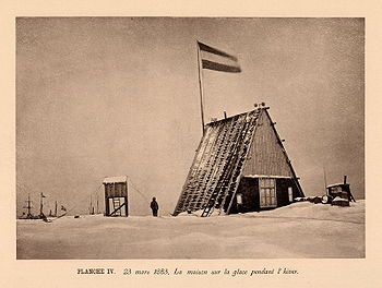 The first major effort by Europeans to study the meteorology of the Arctic was the First International Polar Year
(IPY) in 1882 to 1883. Eleven nations provided support to establish twelve observing stations around the Arctic. The observations were not as widespread or long-lasting as would be needed to describe the climate in detail, but they provided the first cohesive look at the Arctic weather.
In 1884 the wreckage of the Jeanette
, a ship abandoned three years earlier off Russia's eastern Arctic coast, was found on the coast of Greenland. This caused Fridtjof Nansen
to realize that the sea ice was moving from the Siberian side of the Arctic to the Atlantic side. He decided to use this motion by freezing a specially designed ship, the Fram
, into the sea ice and allowing it to be carried across the ocean. Meteorological observations were collected from the ship during its crossing from September 1893 to August 1896. This expedition also provided valuable insight into the circulation of the ice surface of the Arctic Ocean.
In the early 1930s the first significant meteorological studies were carried out on the interior of the Greenland Ice Sheet. These provided knowledge of perhaps the most extreme climate of the Arctic, and also the first suggestion that the ice sheet lies in a depression of the bedrock below (now known to be caused by the weight of the ice itself).
Fifty years after the first IPY, in 1932 to 1933, a second IPY was organized. This one was larger than the first, with 94 meteorological stations, but World War II delayed or prevented the publication of much of the data collected during it (Serreze and Barry 2005). Another significant moment in Arctic observing before World War II occurred in 1937 when the USSR established the first of over 30 North-Pole drifting stations
. This station, like the later ones, was established on a thick ice floe and drifted for almost a year, its crew observing the atmosphere and ocean along the way.
, inadvertently and significantly furthering our understanding of its climate. Between 1947 and 1957, the United States and Canadian governments established a chain of stations along the Arctic coast known as the Distant Early Warning Line (DEWLINE)
to provide warning of a Soviet nuclear attack. Many of these stations also collected meteorological data.
 The Soviet Union was also interested in the Arctic and established a significant presence there by continuing the North-Pole drifting stations. This program operated continuously, with 30 stations in the Arctic from 1950 to 1991. These stations collected data that are valuable to this day for understanding the climate of the Arctic Basin. This map shows the location of Arctic research facilities during the mid 1970s and the tracks of drifting stations between 1958 and 1975.
Another benefit from the Cold War was the acquisition of observations from United States and Soviet naval voyages into the Arctic. In 1958 an American nuclear submarine, the Nautilus
was the first ship to reach the North Pole. In the decades that followed submarines regularly roamed under the Arctic sea ice, collecting sonar observations of the ice thickness and extent as they went. These data became available after the Cold War, and have provided evidence of thinning of the Arctic sea ice. The Soviet navy also operated in the Arctic, including a sailing of the nuclear-powered ice breaker Arktika
to the North Pole in 1977, the first time a surface ship reached the pole.
Scientific expeditions to the Arctic also became more common during the Cold-War decades, sometimes benefiting logistically or financially from the military interest. In 1966 the first deep ice core in Greenland was drilled at Camp Century, providing a glimpse of climate through the last ice age
. This record was lengthened in the early 1990s when two deeper cores were taken from near the center of the Greenland Ice Sheet. Beginning in 1979 the Arctic Ocean Buoy Program (the International Arctic Buoy Program since 1991) has been collecting meteorological and ice-drift data across the Arctic Ocean with a network of 20 to 30 buoys.
The extensive array of satellite-based remote-sensing
instruments now in orbit has helped to replace some of the observations that were lost after the Cold War, and has provided coverage that was impossible without them. Routine satellite observations of the Arctic began in the early 1970s, expanding and improving ever since. A result of these observations is a thorough record of sea-ice extent in the Arctic since 1979; the decreasing extent seen in this record (NASA, NSIDC), and its possible link to anthropogenic global warming, has helped increase interest in the Arctic in recent years. Today's satellite instruments provide routine views of not only cloud, snow, and sea-ice conditions in the Arctic, but also of other, perhaps less-expected, variables, including surface and atmospheric temperatures, atmospheric moisture content, winds, and ozone concentration.
Civilian scientific research on the ground has certainly continued in the Arctic, and it is getting a boost from 2007 to 2009 as nations around the world increase spending on polar research as part of the third International Polar Year. During these two years thousands of scientists from over 60 nations will co-operate to carry out over 200 projects to learn about physical, biological, and social aspects of the Arctic and Antarctic (IPY).
Modern researchers in the Arctic also benefit from computer models. These pieces of software are sometimes relatively simple, but often become highly complex as scientists try to include more and more elements of the environment to make the results more realistic. The models, though imperfect, often provide valuable insight into climate-related questions that cannot be tested in the real world. They are also used to try to predict future climate and the effect that changes to the atmosphere caused by humans may have on the Arctic and beyond. Another interesting use of models has been to use them, along with historical data, to produce a best estimate of the weather conditions over the entire globe during the last 50 years, filling in regions where no observations were made. These reanalysis datasets help compensate for the lack of observations over the Arctic.
 Almost all of the energy available to the Earth's surface and atmosphere comes from the sun in the form of solar radiation (light from the sun, including invisible ultraviolet and infrared light). Variations in the amount of solar radiation reaching different parts of the Earth are a principal driver of global and regional climate. Averaged over a year, latitude
is the most important factor determining the amount of solar radiation reaching the top of the atmosphere; the incident solar radiation decreases smoothly from the Equator to the poles. This variation leads to the most obvious observation of regional climate: temperature tends to decrease with increasing latitude.
In addition the length of each day, which is determined by the season
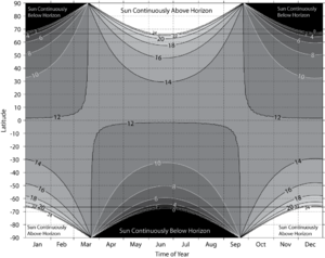
, has a significant impact on the climate. The 24-hour days found near the poles in summer result in a large daily-average solar flux reaching the top of the atmosphere in these regions. On the June solstice 36% more solar radiation reaches the top of the atmosphere over the course of the day at the North Pole than at the Equator (Serreze and Barry, 2005). However in the six months from the September to March equinoxes the North Pole receives no sunlight. Images from the NOAA's North Pole Web Cam illustrate Arctic daylight, darkness and the changing of the seasons.
The climate of the Arctic also depends on the amount of sunlight reaching the surface, and the amount that the surface absorbs are also important. Variations in the frequency of cloud cover can cause significant variations in the amount of solar radiation reaching the surface at locations with the same latitude. Changes in surface conditions, such as the appearance or disappearance of snow or sea ice, can cause large changes in the surface albedo
, the fraction of the solar radiation reaching the surface that is reflected rather than absorbed.
In most of the Arctic the significant snow melt begins in late May or sometime in June. This begins a feedback, as melting snow reflects less solar radiation (50% to 60%) than dry snow, allowing more energy to be absorbed and the melting to take place faster. As the snow disappears on land, the underlying surfaces absorb even more energy, and begin to warm rapidly.
The interior of Greenland differs from the rest of the Arctic. The low springtime cloud frequency there and the high elevation, which reduces the amount of solar radiation absorbed or scattered by the atmosphere, combine to give this region the highest surface flux of solar radiation anywhere in the Arctic. However, the high elevation, and corresponding lower temperatures, help keep the bright snow from melting, limiting the warming effect of all this solar radiation.
 As the Arctic continues receiving energy from the sun during this time, the land, which is mostly free of snow by now, can warm up on clear days when the wind is not coming from the cold ocean. Over the Arctic Ocean the snow cover on the sea ice disappears and ponds of melt water start to form on the sea ice, further reducing the amount of sunlight the ice reflects and helping more ice melt. Around the edges of the Arctic Ocean the ice will melt and break up, exposing the ocean water, which absorbs almost all of the solar radiation that reaches it, storing the energy in the water column. By July and August, most of the land is bare and absorbs more than 80% of the sun's energy that reaches the surface. Where sea ice remains, in the central Arctic Basin and the straits between the islands in the Canadian Archipelago, the many melt ponds and lack of snow cause about half of the sun's energy to be absorbed (Serreze and Barry, 2005), but this mostly goes toward melting ice since the ice surface cannot warm above freezing.
Frequent cloud cover, exceeding 80% frequency over much of the Arctic Ocean in July (Serreze and Barry, 2005), reduces the amount of solar radiation that reaches the surface by reflecting much of it before it gets to the surface. Unusual clear periods can lead to increased sea-ice melt or higher temperatures (NSIDC). The interior of Greenland continues to have less cloud cover than most of the Arctic, so during the summer period, like in spring, this area receives more solar radiation at the surface than any other part of the Arctic. Again though, interior Greenland's permanent snow cover reflects over 80% of this energy away from the surface.
 The Arctic is often perceived as a region stuck in a permanent deep freeze. While much of the region does experience very low temperatures, there is considerable variability with both location and season. Winter temperatures average below freezing over all of the Arctic except for small regions in the southern Norwegian and Bering Seas, which remain ice free throughout the winter. Average temperatures in summer are above freezing over all regions except the central Arctic Basin, where sea ice survives through the summer, and interior Greenland.
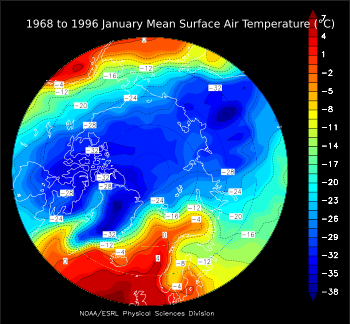
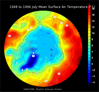
The maps at right show the average temperature over the Arctic in January and July, generally the coldest and warmest months. These maps were made with data from the NCEP/NCAR Reanalysis
, which incorporates available data into a computer model to create a consistent global data set. Neither the models nor the data are perfect, so these maps may differ from other estimates of surface temperatures; in particular, most Arctic climatologies show temperatures over the central Arctic Ocean in July averaging just below freezing, a few degrees lower than these maps show (Serreze and Barry, 2005; USSR, 1985; CIA, 1978). An earlier climatology of temperatures in the Arctic, based entirely on available data, is shown in this map from the CIA Polar Regions Atlas (1978).
Before discussing temperatures across the Arctic, it is worth noting that the coldest location in the Northern Hemisphere is not in the Arctic, but rather in the interior of Russia's Far East, in the upper-right quadrant of the maps. This is due to the region's continental climate
, far from the moderating influence of the ocean, and to the valleys in the region that can trap cold, dense air and create strong temperature inversions, where the temperature increases, rather than decreases, with height (Serreze and Barry, 2005). The lowest officially recorded temperature in the Northern Hemisphere is −67.3 °C (−93.6 °F) in 1892 in Verkhoyansk
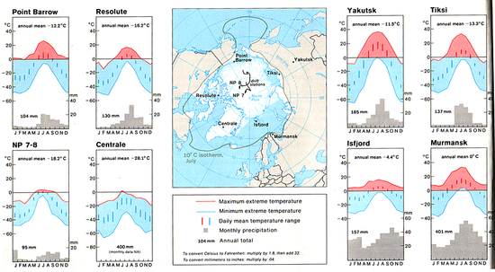
. This region is not part of the Arctic because its continental climate also allows it to have warm summers, with an average July temperature of 15 °C (59 °F) (see the climate chart for Verkhoyansk on the Russian Wikipedia, Верхоянск, or the Google-translated version here). In the figure below showing station climatologies, the plot for Yakutsk is representative of this part of the Far East; Yakutsk has a slightly less extreme climate than Verkhoyansk.
Despite its location centered on the North Pole, and the long period of darkness this brings, this is not the coldest part of the Arctic. In winter, the heat transferred from the −2 °C (28 °F) water through cracks in the ice and areas of open water helps to moderate the climate some, keeping average winter temperatures around −30 to −35 °C (−22 to −31 °F). Minimum temperatures in this region in winter are around −50 °C (−58 °F).
In summer, the sea ice keeps the surface from warming above freezing. Sea ice is mostly fresh water since the salt is rejected by the ice as it forms, so the melting ice has a temperature of 0 °C (32 °F), and any extra energy from the sun goes to melting more ice, not to warming the surface. Air temperatures, at the standard measuring height of about 2 meters above the surface, can rise a few degrees above freezing between late May and September, though they tend to be within a degree of freezing, with very little variability during the height of the melt season.
In the figure above showing station climatologies, the lower-left plot, for NP 7–8, is representative of conditions over the Arctic Basin. This plot shows data from the Soviet North Pole drifting stations, numbers 7 and 8. It shows the average temperature in the coldest months is in the −30s, and the temperature rises rapidly from April to May; July is the warmest month, and the narrowing of the maximum and minimum temperature lines shows the temperature does not vary far from freezing in the middle of summer; from August through December the temperature drops steadily. The small daily temperature range (the length of the vertical bars) results from the fact that the sun's elevation above the horizon does not change much or at all in this region during one day.
Much of the winter variability in this region is due to clouds. Since there is no sunlight, the thermal radiation
emitted by the atmosphere is one of this region's main sources of energy in winter. A cloudy sky can emit much more energy toward the surface than a clear sky, so when it is cloudy in winter, this region tends to be warm, and when it is clear, this region cools quickly (Serreze and Barry, 2005).
The straits between these islands often remain covered by sea ice throughout the summer. This ice acts to keep the surface temperature at freezing, just as it does over the Arctic Basin, so a location on a strait would likely have a summer climate more like the Arctic Basin, but with higher maximum temperatures because of winds off of the nearby warm islands.
. The Greenland Ice Sheet
covers about 80% of Greenland, extending to the coast in places, and has an average elevation of 6900 feet (2,103.1 m) and a maximum elevation of 10500 feet (3,200.4 m). Much of the ice sheet remains below freezing all year, and it has the coldest climate of any part of the Arctic. Coastal areas can be affected by nearby open water, or by heat transfer through sea ice from the ocean, and many parts lose their snow cover in summer, allowing them to absorb more solar radiation and warm more than the interior.
Coastal regions on the northern half of Greenland experience winter temperatures similar to or slightly warmer than the Canadian Archipelago, with average January temperatures of −30 °C to −25 °C (−22 °F to −13 °F). These regions are slightly warmer than the Archipelago because of their closer proximity to areas of thin, first-year sea ice cover or to open ocean in the Baffin Bay and Greenland Sea.
The coastal regions in the southern part of the island are influenced more by open ocean water and by frequent passage of cyclones
, both of which help to keep the temperature there from being as low as in the north. As a result of these influences, the average temperature in these areas in January is considerably higher, between about −20 °C and −4 °C (−4 °F and +25 °F).
The interior ice sheet escapes much of the influence of heat transfer from the ocean or from cyclones, and its high elevation also acts to give it a colder climate since temperatures tend to decrease with elevation. The result is winter temperatures that are lower than anywhere else in the Arctic, with average January temperatures of −45 °C to −30 °C (−49 °F to −22 °F), depending on location and on which data set is viewed. Minimum temperatures in winter over the higher parts of the ice sheet can drop below −60 °C (−76 °F; CIA, 1978). In the station climatology figure above, the Centrale plot is representative of the high Greenland Ice Sheet.
In summer, the coastal regions of Greenland experience temperatures similar to the islands in the Canadian Archipelago, averaging just a few degrees above freezing in July, with slightly higher temperatures in the south and west than in the north and east. The interior ice sheet remains snow covered throughout the summer, though significant portions do experience some snow melt (Serreze and Barry, 2005). This snow cover, combined with the ice sheet's elevation, help to keep temperatures here lower, with July averages between −12 °C and 0 °C (10 °F and 32 °F). Along the coast, temperatures are kept from varying too much by the moderating influence of the nearby water or melting sea ice. In the interior, temperatures are kept from rising much above freezing because of the snow-covered surface but can drop to −30 °C (−22 °F) even in July. Temperatures above 20°C are rare but do sometimes occur in the far south and south-west coastal areas.
, in the southern Bering Sea, the average temperature of the coldest month (February) was −0.6 °C (30.9 °F) and that of the warmest month (August) was 9.7 °C (49.4 °F); temperatures never dropped below −17 °C (+2 °F) or rose above 18 °C (64 °F; Western Regional Climate Center)
The rest of the ice-free seas have ice cover for some part of the winter and spring, but lose that ice during the summer. These regions have summer temperatures between about 0 °C and 8 °C (32 °F and 46 °F). The winter ice cover allows temperatures to drop much lower in these regions than in the regions that are ice-free all year. Over most of the seas that are ice-covered seasonally, winter temperatures average between about −30 °C and −15 °C (−22 °F and +5 °F). Those areas near the sea-ice edge will remain somewhat warmer due to the moderating influence of the nearby open water. In the station-climatology figure above, the plots for Point Barrow, Tiksi, Murmansk, and Isfjord are typical of land areas adjacent to seas that are ice-covered seasonally. The presence of the land allows temperatures to reach slightly more extreme values than the seas themselves.
Accurate climatologies of precipitation amount are more difficult to compile for the Arctic than climatologies of other variables such as temperature and pressure. All variables are measured at relatively few stations in the Arctic, but precipitation observations are made more uncertain due to the difficulty in catching in a gauge all of the snow that falls. Typically some falling snow is kept from entering precipitation gauges by winds, causing an underreporting of precipitation amounts in regions that receive a large fraction of their precipitation as snowfall. Corrections are made to data to account for this uncaught precipitation, but they are not perfect and introduce some error into the climatologies (Serreze and Barry 2005).
The observations that are available show that precipitation amounts vary by about a factor of 10 across the Arctic, with some parts of the Arctic Basin and Canadian Archipelago receiving less than 150 mm (6 in) of precipitation annually, and parts of southeast Greenland receiving over 1200 mm (47 in) annually. Most regions receive less than 500 mm (20 in) annually (Serreze and Hurst 2000, USSR 1985). For comparison, annual precipitation averaged over the whole planet is about 1000 mm (39 in; see Precipitation
). Unless otherwise noted, all precipitation amounts given in this article are liquid-equivalent amounts, meaning that frozen precipitation is melted before it is measured.
. Smaller regions of the Arctic Basin just north of Svalbard
and the Taymyr Peninsula
receive up to about 400 mm (16 in) per year (Serreze and Hurst 2000).
Monthly precipitation totals over most of the Arctic Basin average about 15 mm (0.6 in) from November through May, and rise to 20 to 30 mm (0.8 to 1.2 in) in July, August, and September (Serreze and Hurst 2000). The dry winters result from the low frequency of cyclone
s in the region during that time, and the region's distance from warm open water that could provide a source of moisture (Serreze and Barry 2005). Despite the low precipitation totals in winter, precipitation frequency is higher in January, when 25% to 35% of observations reported precipitation, than in July, when 20% to 25% of observations reported precipitation (Serreze and Barry 2005). Much of the precipitation reported in winter is very light, possibly diamond dust
. The number of days with measurable precipitation (more than 0.1 mm [0.004 in] in a day) is slightly greater in July than in January (USSR 1985). Of January observations reporting precipitation, 95% to 99% of them indicate it was frozen. In July, 40% to 60% of observations reporting precipitation indicate it was frozen (Serreze and Barry 2005).
The parts of the Basin just north of Svalbard and the Taymyr Peninsula are exceptions to the general description just given. These regions receive many weakening cyclones from the North-Atlantic storm track
, which is most active in winter. As a result, precipitation amounts over these parts of the basin are larger in winter than those given above. The warm air transported into these regions also mean that liquid precipitation is more common than over the rest of the Arctic Basin in both winter and summer.
and the smaller islands around it, annual totals increase from just over 200 mm (8 in) in the north to about 500 mm (20 in) in the south, where cyclones from the North Atlantic are more frequent (Serreze and Hurst 2000).
The southern third of Greenland protrudes into the North-Atlantic storm track, a region frequently influenced by cyclones. These frequent cyclones lead to larger annual precipitation totals than over most of the Arctic. This is especially true near the coast, where the terrain rises from sea level to over 2500 m (8200 ft), enhancing precipitation due to orographic lift
. The result is annual precipitation totals of 400 mm (16 in) over the southern interior to over 1200 mm (47 in) near the southern and southeastern coasts. Some locations near these coasts where the terrain is particularly conducive to causing orographic lift receive up 2200 mm (87 in) of precipitation per year. More precipitation falls in winter, when the storm track is most active, than in summer.
The west coast of the central third of Greenland is also influenced by some cyclones and orographic lift, and precipitation totals over the ice sheet slope near this coast are up to 600 mm (24 in) per year. The east coast of the central third of the island receives between 200 and 600 mm (8 and 24 in) of precipitation per year, with increasing amounts from north to south. Precipitation over the north coast is similar to that over the central Arctic Basin.
The interior of the central and northern Greenland Ice Sheet is the driest part of the Arctic. Annual totals here range from less than 100 to about 200 mm (4 to 8 in). This region is continuously below freezing, so all precipitation falls as snow, with more in summer than in winter (USSR 1985).
The Labrador, Norwegian, Greenland, and Barents Seas and Denmark and Davis Straits are strongly influenced by the cyclones in the North Atlantic storm track, which is most active in winter. As a result, these regions receive more precipitation in winter than in summer. Annual precipitation totals increase quickly from about 400 mm (16 in) in the northern to about 1400 mm (55 in) in the southern part of the region (Serreze and Hurst 2000). Precipitation is frequent in winter, with measurable totals falling on an average of 20 days each January in the Norwegian Sea (USSR 1985). The Bering Sea is influenced by the North Pacific storm track, and has annual precipitation totals between 400 mm and 800 mm (16 and 31 in), also with a winter maximum.
 Sea ice
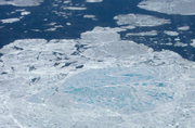
is frozen sea water that floats on the ocean's surface. It is the dominant surface type throughout the year in the Arctic Basin, and covers much of the ocean surface in the Arctic at some point during the year. The ice may be bare ice, or it may be covered by snow or ponds of melt water, depending on location and time of year. Sea ice is relatively thin, generally less than about 4 m (13 feet), with thicker ridges (NSIDC). NOAA's North Pole Web Cams having been tracking the Arctic summer sea ice transitions through spring thaw, summer melt ponds, and autumn freeze-up since the first webcam was deployed in 2002-present.
Sea ice is important to the climate and the ocean in a variety of ways. It reduces the transfer of heat from the ocean to the atmosphere; it causes less solar energy to be absorbed at the surface, and provides a surface on which snow can accumulate, which further decreases the absorption of solar energy; since salt is rejected from the ice as it forms, the ice increases the salinity of the ocean's surface water where it forms and decreases the salinity where it melts, both of which can affect the ocean's circulation (NSIDC).
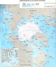
The map at right shows the areas covered by sea ice when it is at its maximum extent (March) and its minimum extent (September). This map was made in the 1970s, and the extent of sea ice has decreased since then (see below), but this still gives a reasonable overview. At its maximum extent, in March, sea ice covers about 15 million km² (5.8 million sq mi) of the Northern Hemisphere, nearly as much area as the largest country, Russia
(UNEP 2007).
Winds and ocean currents cause the sea ice to move. The typical pattern of ice motion is shown on the map at right. On average, these motions carry sea ice from the Russian side of the Arctic Ocean into the Atlantic Ocean through the area east of Greenland, while they cause the ice on the North American side to rotate clockwise, sometimes for many years.
conditions, but they rarely exceed 25 m/s (90 km/h, 55 mph) in these areas (Przybylak 2003).
During all seasons, the strongest average winds are found in the North-Atlantic seas, Baffin Bay, and Bering and Chukchi Seas, where cyclone
activity is most common. On the Atlantic side, the winds are strongest in winter, averaging 7 to 12 m/s (25 to 43 km/h, 16 to 27 mph), and weakest in summer, averaging 5 to 7 m/s (18 to 25 km/h, 11 to 16 mph). On the Pacific side they average 6 to 9 m/s (22 to 32 km/h, 13 to 20 mph) year round. Maximum wind speeds in the Atlantic region can approach 50 m/s (180 km/h, 110 mph) in winter (Przybylak 2003).
s and interglacial periods
over about the last 2 million years, with the last ice age
reaching its maximum extent about 18,000 years ago and ending by about 10,000 years ago. During these ice ages, large areas of northern North America and Eurasia were covered by ice sheets similar to the one found today on Greenland; Arctic climate conditions would have extended much further south, and conditions in the present-day Arctic region were likely colder. Temperature proxies
suggest that over the last 8000 years the climate has been stable, with globally averaged temperature variations of less than about 1 °C (2 °F; see Paleoclimate).
According to the Intergovernmental Panel on Climate Change (IPCC), "warming of the climate system is unequivocal", and the global-mean temperature has increased by 0.6 to 0.9 °C (1.1 to 1.6 °F) over the last century. This report also states that "most of the observed increase in global average temperatures since the mid-20th century is very likely[greater than 90% chance] due to the observed increase in anthropogenic greenhouse gas concentrations." The IPCC also indicate that, over the last 100 years, the annually averaged temperature in the Arctic has increased by almost twice as much as the global mean temperature has. In 2009, NASA reported that 45 percent or more of the observed warming in the Arctic since 1976 was likely a result of changes in tiny airborne particles called aerosols.
There was a period from the late 1920s to the early 1950s during which the Arctic was almost as warm as it is today, though the spatial pattern of today's warming differs from that of the earlier period. Sea ice extent has decreased by 5.25% to 8.25% since 1979, the beginning of the reliable satellite record, with a larger decrease in summer (12.5% to 24.5%) than in winter (IPCC 2007).
Climate models predict that the temperature increase in the Arctic over the next century will continue to be about twice the global average temperature increase. By the end of the 21st century, the annual average temperature in the Arctic is predicted to increase by 2.8 to 7.8 °C (5.0 to 14.0 °F), with more warming in winter (4.3 to 11.4 °C; 7.7 to 20.5 °F) than in summer (IPCC 2007). Decreases in sea-ice extent and thickness are expected to continue over the next century, with some models predicting the Arctic Ocean will be free of sea ice in late summer by the mid to late part of the century (IPCC 2007).
A study published in the journal Science
in September 2009 determined that temperatures in the Arctic are higher presently than they have been at any time in the previous 2,000 years. Samples from ice cores, tree rings and lake sediments from 23 sites were used by the team, led by Darrell Kaufman of Northern Arizona University
, to provide snapshots of the changing climate. Geologists were able to track the summer Arctic temperatures as far back as the time of the Romans by studying natural signals in the landscape. The results highlighted that for around 1,900 years temperatures steadily dropped, caused by precession of earth's orbit that caused the planet to be slightly farther away from the sun during summer in the Northern Hemisphere. These orbital changes led to a cold period known as the little ice age
during the 17th, 18th and 19th centuries. However, during the last 100 years temperatures have been rising, despite the fact that the continued changes in earth's orbit would have driven further cooling. The largest rises have occurred since 1950, with four of the five warmest decades in the last 2,000 years occurring between 1950 and 2000. The last decade was the warmest in the record.
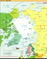
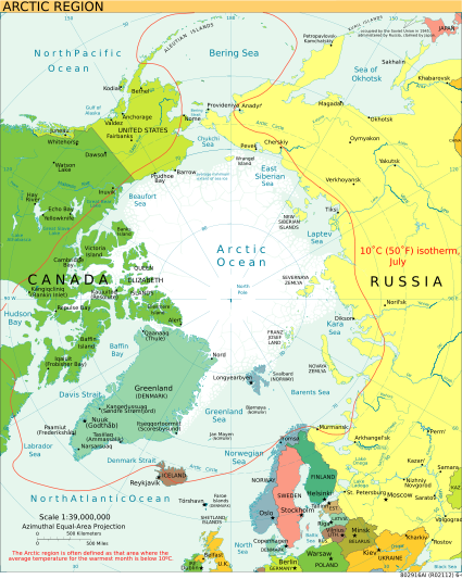
Arctic
The Arctic is a region located at the northern-most part of the Earth. The Arctic consists of the Arctic Ocean and parts of Canada, Russia, Greenland, the United States, Norway, Sweden, Finland, and Iceland. The Arctic region consists of a vast, ice-covered ocean, surrounded by treeless permafrost...
is characterized by long, cold winters and short, cool summers. There is a large amount of variability in climate
Climate
Climate encompasses the statistics of temperature, humidity, atmospheric pressure, wind, rainfall, atmospheric particle count and other meteorological elemental measurements in a given region over long periods...
across the Arctic, but all regions experience extremes of solar radiation in both summer and winter. Some parts of the Arctic are covered by ice (sea ice
Sea ice
Sea ice is largely formed from seawater that freezes. Because the oceans consist of saltwater, this occurs below the freezing point of pure water, at about -1.8 °C ....
, glacial ice
Glacier
A glacier is a large persistent body of ice that forms where the accumulation of snow exceeds its ablation over many years, often centuries. At least 0.1 km² in area and 50 m thick, but often much larger, a glacier slowly deforms and flows due to stresses induced by its weight...
, or snow
Snow
Snow is a form of precipitation within the Earth's atmosphere in the form of crystalline water ice, consisting of a multitude of snowflakes that fall from clouds. Since snow is composed of small ice particles, it is a granular material. It has an open and therefore soft structure, unless packed by...
) year-round, and nearly all parts of the Arctic experience long periods with some form of ice on the surface. Average January temperatures range from about −40 to 0 °C (−40 to +32 °F), and winter temperatures can drop below −50 °C (−58 °F) over large parts of the Arctic. Average July temperatures range from about −10 to +10 °C (14 to 50 °F), with some land areas occasionally exceeding 30 °C (86 °F) in summer.
The Arctic consists of ocean that is largely surrounded by land. As such, the climate of much of the Arctic is moderated by the ocean water, which can never have a temperature below −2 °C (28 °F). In winter, this relatively warm water, even though covered by the polar ice pack, keeps the North Pole
North Pole
The North Pole, also known as the Geographic North Pole or Terrestrial North Pole, is, subject to the caveats explained below, defined as the point in the northern hemisphere where the Earth's axis of rotation meets its surface...
from being the coldest place in the Northern Hemisphere
Northern Hemisphere
The Northern Hemisphere is the half of a planet that is north of its equator—the word hemisphere literally means “half sphere”. It is also that half of the celestial sphere north of the celestial equator...
, and it is also part of the reason that Antarctica is so much colder than the Arctic. In summer, the presence of the near-by water keeps coastal areas from warming as much as they might otherwise.
Origin of the Arctic climate
It is possible that this is the first time in the Earth's history that both poles have been simultaneously ice-bound. This unusual climate was created in the Azolla eventAzolla event
The Azolla event occurred in the middle Eocene period, around , when blooms of the freshwater fern Azolla are thought to have happened in the Arctic Ocean...
when fresh surface water in the Arctic Ocean
Arctic Ocean
The Arctic Ocean, located in the Northern Hemisphere and mostly in the Arctic north polar region, is the smallest and shallowest of the world's five major oceanic divisions...
caused a long term abundance of Azolla, a type of aquatic fern. Huge quantities of dead Azolla built up and formed sedimentary rock
Sedimentary rock
Sedimentary rock are types of rock that are formed by the deposition of material at the Earth's surface and within bodies of water. Sedimentation is the collective name for processes that cause mineral and/or organic particles to settle and accumulate or minerals to precipitate from a solution....
, much of which contains fossil fuels as a result of the carbon
Carbon
Carbon is the chemical element with symbol C and atomic number 6. As a member of group 14 on the periodic table, it is nonmetallic and tetravalent—making four electrons available to form covalent chemical bonds...
contained in the Azolla. This process caused global cooling
Global cooling
Global cooling was a conjecture during the 1970s of imminent cooling of the Earth's surface and atmosphere along with a posited commencement of glaciation...
as a result of a reduction in the greenhouse effect
Greenhouse effect
The greenhouse effect is a process by which thermal radiation from a planetary surface is absorbed by atmospheric greenhouse gases, and is re-radiated in all directions. Since part of this re-radiation is back towards the surface, energy is transferred to the surface and the lower atmosphere...
. Release of stored carbon
Carbon
Carbon is the chemical element with symbol C and atomic number 6. As a member of group 14 on the periodic table, it is nonmetallic and tetravalent—making four electrons available to form covalent chemical bonds...
into the atmosphere
Atmosphere
An atmosphere is a layer of gases that may surround a material body of sufficient mass, and that is held in place by the gravity of the body. An atmosphere may be retained for a longer duration, if the gravity is high and the atmosphere's temperature is low...
as a result of current fossil fuel
Fossil fuel
Fossil fuels are fuels formed by natural processes such as anaerobic decomposition of buried dead organisms. The age of the organisms and their resulting fossil fuels is typically millions of years, and sometimes exceeds 650 million years...
use is causing global warming
Global warming
Global warming refers to the rising average temperature of Earth's atmosphere and oceans and its projected continuation. In the last 100 years, Earth's average surface temperature increased by about with about two thirds of the increase occurring over just the last three decades...
, which threatens to destroy the climatic conditions necessary for the current Arctic climate.
Overview of the Arctic
There are different definitions of the Arctic. The most widely used definition, the area north of the Arctic CircleArctic Circle
The Arctic Circle is one of the five major circles of latitude that mark maps of the Earth. For Epoch 2011, it is the parallel of latitude that runs north of the Equator....
, where, on the June solstice, the sun does not set is used in astronomical and some geographical contexts. However, in a context of climate, the two most widely used definitions in this context are the area north of the northern tree line, and the area in which the average temperature of the warmest month is less than 10 °C (50 °F), which are nearly coincident over most land areas (NSIDC).
This definition of the Arctic can be further divided into four different regions:
- The Arctic Basin includes the Arctic Ocean within the average minimum extent of sea ice.
- The Canadian Arctic ArchipelagoCanadian Arctic ArchipelagoThe Canadian Arctic Archipelago, also known as the Arctic Archipelago, is a Canadian archipelago north of the Canadian mainland in the Arctic...
includes the large and small islands, except Greenland, on the Canadian side of the Arctic, and the waters between them. - The entire island of Greenland, although its ice sheetGreenland ice sheetThe Greenland ice sheet is a vast body of ice covering , roughly 80% of the surface of Greenland. It is the second largest ice body in the world, after the Antarctic Ice Sheet. The ice sheet is almost long in a north-south direction, and its greatest width is at a latitude of 77°N, near its...
and ice-free coastal regions have different climatic conditions. - The Arctic waters that are not covered by sea ice in late summer, including Hudson BayHudson BayHudson Bay , sometimes called Hudson's Bay, is a large body of saltwater in northeastern Canada. It drains a very large area, about , that includes parts of Ontario, Quebec, Saskatchewan, Alberta, most of Manitoba, southeastern Nunavut, as well as parts of North Dakota, South Dakota, Minnesota,...
, Baffin BayBaffin BayBaffin Bay , located between Baffin Island and the southwest coast of Greenland, is a marginal sea of the North Atlantic Ocean. It is connected to the Atlantic via Davis Strait and the Labrador Sea...
, Ungava BayUngava BayUngava Bay is a large bay in northeastern Canada separating Nunavik from Baffin Island. The bay is shaped like a rounded square with a side length of about and has an area of approximately...
, the DavisDavis StraitDavis Strait is a northern arm of the Labrador Sea. It lies between mid-western Greenland and Nunavut, Canada's Baffin Island. The strait was named for the English explorer John Davis , who explored the area while seeking a Northwest Passage....
, DenmarkDenmark StraitThe Denmark Strait or Greenland Strait |Sound]]) is an oceanic strait between Greenland and Iceland...
, HudsonHudson StraitHudson Strait links the Atlantic Ocean to Hudson Bay in Canada. It lies between Baffin Island and the northern coast of Quebec, its eastern entrance marked by Cape Chidley and Resolution Island. It is long...
and Bering StraitBering StraitThe Bering Strait , known to natives as Imakpik, is a sea strait between Cape Dezhnev, Chukotka Autonomous Okrug, Russia, the easternmost point of the Asian continent and Cape Prince of Wales, Alaska, USA, the westernmost point of the North American continent, with latitude of about 65°40'N,...
s, and the LabradorLabrador SeaThe Labrador Sea is an arm of the North Atlantic Ocean between the Labrador Peninsula and Greenland. The sea is flanked by continental shelves to the southwest, northwest, and northeast. It connects to the north with Baffin Bay through the Davis Strait...
, NorwegianNorwegian SeaThe Norwegian Sea is a marginal sea in the North Atlantic Ocean, northwest of Norway. It is located between the North Sea and the Greenland Sea and adjoins the North Atlantic Ocean to the west and the Barents Sea to the northeast. In the southwest, it is separated from the Atlantic Ocean by a...
, (ice-free all year), GreenlandGreenland SeaThe Greenland Sea is a body of water that borders Greenland to the west, the Svalbard archipelago to the east, Fram Strait and the Arctic Ocean to the north, and the Norwegian Sea and Iceland to the south. The Greenland Sea is often defined as part of the Arctic Ocean, sometimes as part of the...
, BalticBaltic SeaThe Baltic Sea is a brackish mediterranean sea located in Northern Europe, from 53°N to 66°N latitude and from 20°E to 26°E longitude. It is bounded by the Scandinavian Peninsula, the mainland of Europe, and the Danish islands. It drains into the Kattegat by way of the Øresund, the Great Belt and...
, BarentsBarents SeaThe Barents Sea is a marginal sea of the Arctic Ocean, located north of Norway and Russia. Known in the Middle Ages as the Murman Sea, the sea takes its current name from the Dutch navigator Willem Barents...
(southern part ice-free all year), KaraKara SeaThe Kara Sea is part of the Arctic Ocean north of Siberia. It is separated from the Barents Sea to the west by the Kara Strait and Novaya Zemlya, and the Laptev Sea to the east by the Severnaya Zemlya....
, LaptevLaptev SeaThe Laptev Sea is a marginal sea of the Arctic Ocean. It is located between the northern coast of Siberia, the Taimyr Peninsula, Severnaya Zemlya and the New Siberian Islands. Its northern boundary passes from the Arctic Cape to a point with co-ordinates of 79°N and 139°E, and ends at the Anisiy...
, ChukchiChukchi SeaChukchi Sea is a marginal sea of the Arctic Ocean. It is bounded on the west by the De Long Strait, off Wrangel Island, and in the east by Point Barrow, Alaska, beyond which lies the Beaufort Sea. The Bering Strait forms its southernmost limit and connects it to the Bering Sea and the Pacific...
, OkhotskSea of OkhotskThe Sea of Okhotsk is a marginal sea of the western Pacific Ocean, lying between the Kamchatka Peninsula on the east, the Kuril Islands on the southeast, the island of Hokkaidō to the far south, the island of Sakhalin along the west, and a long stretch of eastern Siberian coast along the west and...
, sometimes BeaufortBeaufort SeaThe Beaufort Sea is a marginal sea of the Arctic Ocean, located north of the Northwest Territories, the Yukon, and Alaska, west of Canada's Arctic islands. The sea is named after hydrographer Sir Francis Beaufort...
and Bering SeaBering SeaThe Bering Sea is a marginal sea of the Pacific Ocean. It comprises a deep water basin, which then rises through a narrow slope into the shallower water above the continental shelves....
s.
Moving inland from the coast over mainland North America and Eurasia, the moderating influence of the Arctic Ocean quickly diminishes, and the climate transitions from Arctic to subarctic
Subarctic climate
The subarctic climate is a climate characterized by long, usually very cold winters, and short, cool to mild summers. It is found on large landmasses, away from the moderating effects of an ocean, generally at latitudes from 50° to 70°N poleward of the humid continental climates...
, generally in less than 500 kilometres (300 mi), and often over a much shorter distance.
History of Arctic climate observation
Due to the lack of major population centres in the Arctic, weather and climate observations from the region tend to be widely spaced and of short duration compared to the midlatitudes and tropics. Though the Vikings explored parts of the Arctic over a millennium ago, and small numbers of people have been living along the Arctic coast for much longer, scientific knowledge about the region was slow to develop; the large islands of Severnaya ZemlyaSevernaya Zemlya
Severnaya Zemlya is an archipelago in the Russian high Arctic at around . It is located off mainland Siberia's Taymyr Peninsula across the Vilkitsky Strait...
, just north of the Taymyr Peninsula on the Russian mainland, were not discovered until 1913, and not mapped until the early 1930s (Serreze and Barry, 2005).
Early European exploration
Much of the historical exploration of the Arctic was motivated by the search for the NorthwestNorthwest Passage
The Northwest Passage is a sea route through the Arctic Ocean, along the northern coast of North America via waterways amidst the Canadian Arctic Archipelago, connecting the Atlantic and Pacific Oceans...
and Northeast Passages. Sixteenth- and seventeenth-century expeditions were largely driven by traders in search of these shortcuts between the Atlantic and the Pacific. These forays into the Arctic did not venture far from the North American and Eurasian coasts, and were unsuccessful at finding a navigable route through either passage.
National and commercial expeditions continued to expand the detail on maps of the Arctic through the eighteenth century, but largely neglected other scientific observations. Expeditions from the 1760s to the middle of the 19th century were also led astray by attempts to sail north because of the belief by many at the time that the ocean surrounding the North Pole was ice-free. These early explorations did provide a sense of the sea ice conditions in the Arctic and occasionally some other climate-related information.
By the early 19th century some expeditions were making a point of collecting more detailed meteorological, oceanographic, and geomagnetic observations, but they remained sporadic. Beginning in the 1850s regular meteorological observations became more common in many countries, and the British navy implemented a system of detailed observation (Serreze and Barry, 2005). As a result, expeditions from the second half of the nineteenth century began to provide a picture of the Arctic climate.
Early European observing efforts
International Polar Year
The International Polar Year is a collaborative, international effort researching the polar regions. Karl Weyprecht, an Austro-Hungarian naval officer, motivated the endeavor, but died before it first occurred in 1882-1883. Fifty years later a second IPY occurred...
(IPY) in 1882 to 1883. Eleven nations provided support to establish twelve observing stations around the Arctic. The observations were not as widespread or long-lasting as would be needed to describe the climate in detail, but they provided the first cohesive look at the Arctic weather.
In 1884 the wreckage of the Jeanette
USS Jeannette (1878)
The first USS Jeannette was originally HMS Pandora, a Philomel-class gunvessel of the Royal Navy, and was purchased in 1875 by Sir Allen Young for his arctic voyages in 1875-1876. The ship was purchased in 1878 by James Gordon Bennett, Jr., owner of the New York Herald; and renamed Jeannette...
, a ship abandoned three years earlier off Russia's eastern Arctic coast, was found on the coast of Greenland. This caused Fridtjof Nansen
Fridtjof Nansen
Fridtjof Wedel-Jarlsberg Nansen was a Norwegian explorer, scientist, diplomat, humanitarian and Nobel Peace Prize laureate. In his youth a champion skier and ice skater, he led the team that made the first crossing of the Greenland interior in 1888, and won international fame after reaching a...
to realize that the sea ice was moving from the Siberian side of the Arctic to the Atlantic side. He decided to use this motion by freezing a specially designed ship, the Fram
Fram
Fram is a ship that was used in expeditions of the Arctic and Antarctic regions by the Norwegian explorers Fridtjof Nansen, Otto Sverdrup, Oscar Wisting, and Roald Amundsen between 1893 and 1912...
, into the sea ice and allowing it to be carried across the ocean. Meteorological observations were collected from the ship during its crossing from September 1893 to August 1896. This expedition also provided valuable insight into the circulation of the ice surface of the Arctic Ocean.
In the early 1930s the first significant meteorological studies were carried out on the interior of the Greenland Ice Sheet. These provided knowledge of perhaps the most extreme climate of the Arctic, and also the first suggestion that the ice sheet lies in a depression of the bedrock below (now known to be caused by the weight of the ice itself).
Fifty years after the first IPY, in 1932 to 1933, a second IPY was organized. This one was larger than the first, with 94 meteorological stations, but World War II delayed or prevented the publication of much of the data collected during it (Serreze and Barry 2005). Another significant moment in Arctic observing before World War II occurred in 1937 when the USSR established the first of over 30 North-Pole drifting stations
Soviet and Russian manned drifting ice stations
Soviet and Russian manned drifting ice stations are important contributors to exploration of the Arctic. The stations are named North Pole Soviet and Russian manned drifting ice stations are important contributors to exploration of the Arctic. The stations are named North Pole Soviet and...
. This station, like the later ones, was established on a thick ice floe and drifted for almost a year, its crew observing the atmosphere and ocean along the way.
Cold-War era observations
Following World War II, the Arctic, lying between the USSR and North America, became a front line of the Cold WarCold War
The Cold War was the continuing state from roughly 1946 to 1991 of political conflict, military tension, proxy wars, and economic competition between the Communist World—primarily the Soviet Union and its satellite states and allies—and the powers of the Western world, primarily the United States...
, inadvertently and significantly furthering our understanding of its climate. Between 1947 and 1957, the United States and Canadian governments established a chain of stations along the Arctic coast known as the Distant Early Warning Line (DEWLINE)
Distant Early Warning Line
The Distant Early Warning Line, also known as the DEW Line or Early Warning Line, was a system of radar stations in the far northern Arctic region of Canada, with additional stations along the North Coast and Aleutian Islands of Alaska, in addition to the Faroe Islands, Greenland, and Iceland...
to provide warning of a Soviet nuclear attack. Many of these stations also collected meteorological data.
Another benefit from the Cold War was the acquisition of observations from United States and Soviet naval voyages into the Arctic. In 1958 an American nuclear submarine, the Nautilus
USS Nautilus (SSN-571)
USS Nautilus is the world's first operational nuclear-powered submarine. She was the first vessel to complete a submerged transit beneath the North Pole on August 3, 1958...
was the first ship to reach the North Pole. In the decades that followed submarines regularly roamed under the Arctic sea ice, collecting sonar observations of the ice thickness and extent as they went. These data became available after the Cold War, and have provided evidence of thinning of the Arctic sea ice. The Soviet navy also operated in the Arctic, including a sailing of the nuclear-powered ice breaker Arktika
Arktika (icebreaker)
NS Arktika is a nuclear powered icebreaker of the Soviet Arktika class. In service since 1975, she was the first surface ship to reach the North Pole, on August 17, 1977....
to the North Pole in 1977, the first time a surface ship reached the pole.
Scientific expeditions to the Arctic also became more common during the Cold-War decades, sometimes benefiting logistically or financially from the military interest. In 1966 the first deep ice core in Greenland was drilled at Camp Century, providing a glimpse of climate through the last ice age
Wisconsin glaciation
The last glacial period was the most recent glacial period within the current ice age occurring during the last years of the Pleistocene, from approximately 110,000 to 10,000 years ago....
. This record was lengthened in the early 1990s when two deeper cores were taken from near the center of the Greenland Ice Sheet. Beginning in 1979 the Arctic Ocean Buoy Program (the International Arctic Buoy Program since 1991) has been collecting meteorological and ice-drift data across the Arctic Ocean with a network of 20 to 30 buoys.
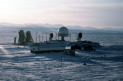
Satellite era
The end of the Soviet Union in 1991 led to a dramatic decrease in regular observations from the Arctic. The Russian government ended the system of drifting North Pole stations, and closed many of the surface stations in the Russian Arctic. Likewise the United States and Canadian governments cut back on spending for Arctic observing as the perceived need for the DEWLINE declined. As a result, the most complete collection of surface observations from the Arctic is for the period 1960 to 1990 (Serreze and Barry, 2005).The extensive array of satellite-based remote-sensing
Remote sensing
Remote sensing is the acquisition of information about an object or phenomenon, without making physical contact with the object. In modern usage, the term generally refers to the use of aerial sensor technologies to detect and classify objects on Earth by means of propagated signals Remote sensing...
instruments now in orbit has helped to replace some of the observations that were lost after the Cold War, and has provided coverage that was impossible without them. Routine satellite observations of the Arctic began in the early 1970s, expanding and improving ever since. A result of these observations is a thorough record of sea-ice extent in the Arctic since 1979; the decreasing extent seen in this record (NASA, NSIDC), and its possible link to anthropogenic global warming, has helped increase interest in the Arctic in recent years. Today's satellite instruments provide routine views of not only cloud, snow, and sea-ice conditions in the Arctic, but also of other, perhaps less-expected, variables, including surface and atmospheric temperatures, atmospheric moisture content, winds, and ozone concentration.
Civilian scientific research on the ground has certainly continued in the Arctic, and it is getting a boost from 2007 to 2009 as nations around the world increase spending on polar research as part of the third International Polar Year. During these two years thousands of scientists from over 60 nations will co-operate to carry out over 200 projects to learn about physical, biological, and social aspects of the Arctic and Antarctic (IPY).
Modern researchers in the Arctic also benefit from computer models. These pieces of software are sometimes relatively simple, but often become highly complex as scientists try to include more and more elements of the environment to make the results more realistic. The models, though imperfect, often provide valuable insight into climate-related questions that cannot be tested in the real world. They are also used to try to predict future climate and the effect that changes to the atmosphere caused by humans may have on the Arctic and beyond. Another interesting use of models has been to use them, along with historical data, to produce a best estimate of the weather conditions over the entire globe during the last 50 years, filling in regions where no observations were made. These reanalysis datasets help compensate for the lack of observations over the Arctic.
Solar radiation
Latitude
In geography, the latitude of a location on the Earth is the angular distance of that location south or north of the Equator. The latitude is an angle, and is usually measured in degrees . The equator has a latitude of 0°, the North pole has a latitude of 90° north , and the South pole has a...
is the most important factor determining the amount of solar radiation reaching the top of the atmosphere; the incident solar radiation decreases smoothly from the Equator to the poles. This variation leads to the most obvious observation of regional climate: temperature tends to decrease with increasing latitude.
In addition the length of each day, which is determined by the season
Season
A season is a division of the year, marked by changes in weather, ecology, and hours of daylight.Seasons result from the yearly revolution of the Earth around the Sun and the tilt of the Earth's axis relative to the plane of revolution...
, has a significant impact on the climate. The 24-hour days found near the poles in summer result in a large daily-average solar flux reaching the top of the atmosphere in these regions. On the June solstice 36% more solar radiation reaches the top of the atmosphere over the course of the day at the North Pole than at the Equator (Serreze and Barry, 2005). However in the six months from the September to March equinoxes the North Pole receives no sunlight. Images from the NOAA's North Pole Web Cam illustrate Arctic daylight, darkness and the changing of the seasons.
The climate of the Arctic also depends on the amount of sunlight reaching the surface, and the amount that the surface absorbs are also important. Variations in the frequency of cloud cover can cause significant variations in the amount of solar radiation reaching the surface at locations with the same latitude. Changes in surface conditions, such as the appearance or disappearance of snow or sea ice, can cause large changes in the surface albedo
Albedo
Albedo , or reflection coefficient, is the diffuse reflectivity or reflecting power of a surface. It is defined as the ratio of reflected radiation from the surface to incident radiation upon it...
, the fraction of the solar radiation reaching the surface that is reflected rather than absorbed.
Winter
In the Arctic, during the winter months of November through February, the sun remains very low in the sky or does not rise at all. Where it does rise, the days are short, and the sun's low position in the sky means that, even at noon, not much energy is reaching the surface. Furthermore, most of the small amount of solar radiation that reaches the surface is reflected away by the bright snow cover. Cold snow reflects between 70% and 90% of the solar radiation that reaches it (Serreze and Barry, 2005), and most of the Arctic, with the exception of the ice-free parts of the sea, have snow covering the land or ice surface in winter. These factors result in a negligible input of solar energy to the Arctic in winter; the only things keeping the Arctic from continuously cooling all winter are the transport of warmer air and ocean water into the Arctic from the south and the transfer of heat from the subsurface land and ocean (both of which gain heat in summer and release it in winter) to the surface and atmosphere.Spring
Arctic days lengthen rapidly in March and April, and the sun rises higher in the sky during this time as well. Both of these changes bring more solar radiation to the Arctic during this period. During these early months of Northern Hemisphere spring most of the Arctic is still experiencing winter conditions, but with the addition of sunlight. The continued low temperatures, and the persisting snow cover, mean that this additional energy reaching the Arctic from the sun is slow to have a significant impact because it is mostly reflected away without warming the surface. By May, temperatures are rising, as 24-hour daylight reaches many areas, but most of the Arctic is still snow covered, so the Arctic surface reflects more than 70% of the sun's energy that reaches it over all areas but the Norwegian Sea and southern Bering Sea, where the ocean is ice free, and some of the land areas adjacent to these seas, where the moderating influence of the open water helps melt the snow early (Serreze and Barry, 2005).In most of the Arctic the significant snow melt begins in late May or sometime in June. This begins a feedback, as melting snow reflects less solar radiation (50% to 60%) than dry snow, allowing more energy to be absorbed and the melting to take place faster. As the snow disappears on land, the underlying surfaces absorb even more energy, and begin to warm rapidly.
The interior of Greenland differs from the rest of the Arctic. The low springtime cloud frequency there and the high elevation, which reduces the amount of solar radiation absorbed or scattered by the atmosphere, combine to give this region the highest surface flux of solar radiation anywhere in the Arctic. However, the high elevation, and corresponding lower temperatures, help keep the bright snow from melting, limiting the warming effect of all this solar radiation.
Summer
At the North Pole on the June solstice, around 21 June, the sun circles overhead at 23.5° above the horizon. This marks noon in the Pole's year-long day; from then until the September equinox, the sun will slowly approach nearer and nearer the horizon, offering less and less solar radiation to the Pole. This period of setting sun also roughly corresponds to summer in the Arctic. The rest of the Arctic will have the sun get lower in the sky and receive progressively shorter days.Frequent cloud cover, exceeding 80% frequency over much of the Arctic Ocean in July (Serreze and Barry, 2005), reduces the amount of solar radiation that reaches the surface by reflecting much of it before it gets to the surface. Unusual clear periods can lead to increased sea-ice melt or higher temperatures (NSIDC). The interior of Greenland continues to have less cloud cover than most of the Arctic, so during the summer period, like in spring, this area receives more solar radiation at the surface than any other part of the Arctic. Again though, interior Greenland's permanent snow cover reflects over 80% of this energy away from the surface.
Autumn
In September and October the days get rapidly shorter, and in northern areas the sun disappears from the sky entirely. As the amount of solar radiation available to the surface rapidly decreases, the temperatures follow suit. The sea ice begins to refreeze, and eventually gets a fresh snow cover, causing it to reflect even more of the dwindling amount of sunlight reaching it. Likewise, the northern land areas receive their winter snow cover, which combined with the reduced solar radiation at the surface, ensures an end to the warm days those areas may experience in summer. By November, winter is in full swing in most of the Arctic, and the small amount of solar radiation still reaching the region does not play a significant role in its climate.Temperature
The maps at right show the average temperature over the Arctic in January and July, generally the coldest and warmest months. These maps were made with data from the NCEP/NCAR Reanalysis
NCEP/NCAR Reanalysis
The NCEP/NCAR Reanalysis reanalysis data set is a continually updating gridded data set representing the state of the Earth's atmosphere, incorporating observations and numerical weather prediction model output dating back to 1948...
, which incorporates available data into a computer model to create a consistent global data set. Neither the models nor the data are perfect, so these maps may differ from other estimates of surface temperatures; in particular, most Arctic climatologies show temperatures over the central Arctic Ocean in July averaging just below freezing, a few degrees lower than these maps show (Serreze and Barry, 2005; USSR, 1985; CIA, 1978). An earlier climatology of temperatures in the Arctic, based entirely on available data, is shown in this map from the CIA Polar Regions Atlas (1978).
Before discussing temperatures across the Arctic, it is worth noting that the coldest location in the Northern Hemisphere is not in the Arctic, but rather in the interior of Russia's Far East, in the upper-right quadrant of the maps. This is due to the region's continental climate
Continental climate
Continental climate is a climate characterized by important annual variation in temperature due to the lack of significant bodies of water nearby...
, far from the moderating influence of the ocean, and to the valleys in the region that can trap cold, dense air and create strong temperature inversions, where the temperature increases, rather than decreases, with height (Serreze and Barry, 2005). The lowest officially recorded temperature in the Northern Hemisphere is −67.3 °C (−93.6 °F) in 1892 in Verkhoyansk
Verkhoyansk
Verkhoyansk is a town in Verkhoyansky District of the Sakha Republic, Russia, situated on the Yana River, near the Arctic Circle, from Yakutsk. Population: There is a river port, an airport, a fur-collecting depot, and the center of a reindeer-raising area....
. This region is not part of the Arctic because its continental climate also allows it to have warm summers, with an average July temperature of 15 °C (59 °F) (see the climate chart for Verkhoyansk on the Russian Wikipedia, Верхоянск, or the Google-translated version here). In the figure below showing station climatologies, the plot for Yakutsk is representative of this part of the Far East; Yakutsk has a slightly less extreme climate than Verkhoyansk.
Arctic Basin
The Arctic Basin is typically covered by sea ice year round, which strongly influences its summer temperatures. It also experiences the longest period without sunlight of any part of the Arctic, and the longest period of continuous sunlight, though the frequent cloudiness in summer reduces the importance of this solar radiation.Despite its location centered on the North Pole, and the long period of darkness this brings, this is not the coldest part of the Arctic. In winter, the heat transferred from the −2 °C (28 °F) water through cracks in the ice and areas of open water helps to moderate the climate some, keeping average winter temperatures around −30 to −35 °C (−22 to −31 °F). Minimum temperatures in this region in winter are around −50 °C (−58 °F).
In summer, the sea ice keeps the surface from warming above freezing. Sea ice is mostly fresh water since the salt is rejected by the ice as it forms, so the melting ice has a temperature of 0 °C (32 °F), and any extra energy from the sun goes to melting more ice, not to warming the surface. Air temperatures, at the standard measuring height of about 2 meters above the surface, can rise a few degrees above freezing between late May and September, though they tend to be within a degree of freezing, with very little variability during the height of the melt season.
In the figure above showing station climatologies, the lower-left plot, for NP 7–8, is representative of conditions over the Arctic Basin. This plot shows data from the Soviet North Pole drifting stations, numbers 7 and 8. It shows the average temperature in the coldest months is in the −30s, and the temperature rises rapidly from April to May; July is the warmest month, and the narrowing of the maximum and minimum temperature lines shows the temperature does not vary far from freezing in the middle of summer; from August through December the temperature drops steadily. The small daily temperature range (the length of the vertical bars) results from the fact that the sun's elevation above the horizon does not change much or at all in this region during one day.
Much of the winter variability in this region is due to clouds. Since there is no sunlight, the thermal radiation
Thermal radiation
Thermal radiation is electromagnetic radiation generated by the thermal motion of charged particles in matter. All matter with a temperature greater than absolute zero emits thermal radiation....
emitted by the atmosphere is one of this region's main sources of energy in winter. A cloudy sky can emit much more energy toward the surface than a clear sky, so when it is cloudy in winter, this region tends to be warm, and when it is clear, this region cools quickly (Serreze and Barry, 2005).
Canadian Archipelago
In winter, the Canadian Archipelago experiences temperatures similar to those in the Arctic Basin, but in the summer months of June to August, the presence of so much land in this region allows it to warm more than the ice-covered Arctic Basin. In the station-climatology figure above, the plot for Resolute is typical of this region. The presence of the islands, most of which lose their snow cover in summer, allows the summer temperatures to rise well above freezing. The average high temperature in summer approaches 10 °C (50 °F), and the average low temperature in July is above freezing, though temperatures below freezing are observed every month of the year.The straits between these islands often remain covered by sea ice throughout the summer. This ice acts to keep the surface temperature at freezing, just as it does over the Arctic Basin, so a location on a strait would likely have a summer climate more like the Arctic Basin, but with higher maximum temperatures because of winds off of the nearby warm islands.
Greenland
Climatically, Greenland is divided into two very separate regions: the coastal region, much of which is ice free, and the inland ice sheetIce sheet
An ice sheet is a mass of glacier ice that covers surrounding terrain and is greater than 50,000 km² , thus also known as continental glacier...
. The Greenland Ice Sheet
Greenland ice sheet
The Greenland ice sheet is a vast body of ice covering , roughly 80% of the surface of Greenland. It is the second largest ice body in the world, after the Antarctic Ice Sheet. The ice sheet is almost long in a north-south direction, and its greatest width is at a latitude of 77°N, near its...
covers about 80% of Greenland, extending to the coast in places, and has an average elevation of 6900 feet (2,103.1 m) and a maximum elevation of 10500 feet (3,200.4 m). Much of the ice sheet remains below freezing all year, and it has the coldest climate of any part of the Arctic. Coastal areas can be affected by nearby open water, or by heat transfer through sea ice from the ocean, and many parts lose their snow cover in summer, allowing them to absorb more solar radiation and warm more than the interior.
Coastal regions on the northern half of Greenland experience winter temperatures similar to or slightly warmer than the Canadian Archipelago, with average January temperatures of −30 °C to −25 °C (−22 °F to −13 °F). These regions are slightly warmer than the Archipelago because of their closer proximity to areas of thin, first-year sea ice cover or to open ocean in the Baffin Bay and Greenland Sea.
The coastal regions in the southern part of the island are influenced more by open ocean water and by frequent passage of cyclones
Extratropical cyclone
Extratropical cyclones, sometimes called mid-latitude cyclones or wave cyclones, are a group of cyclones defined as synoptic scale low pressure weather systems that occur in the middle latitudes of the Earth having neither tropical nor polar characteristics, and are connected with fronts and...
, both of which help to keep the temperature there from being as low as in the north. As a result of these influences, the average temperature in these areas in January is considerably higher, between about −20 °C and −4 °C (−4 °F and +25 °F).
The interior ice sheet escapes much of the influence of heat transfer from the ocean or from cyclones, and its high elevation also acts to give it a colder climate since temperatures tend to decrease with elevation. The result is winter temperatures that are lower than anywhere else in the Arctic, with average January temperatures of −45 °C to −30 °C (−49 °F to −22 °F), depending on location and on which data set is viewed. Minimum temperatures in winter over the higher parts of the ice sheet can drop below −60 °C (−76 °F; CIA, 1978). In the station climatology figure above, the Centrale plot is representative of the high Greenland Ice Sheet.
In summer, the coastal regions of Greenland experience temperatures similar to the islands in the Canadian Archipelago, averaging just a few degrees above freezing in July, with slightly higher temperatures in the south and west than in the north and east. The interior ice sheet remains snow covered throughout the summer, though significant portions do experience some snow melt (Serreze and Barry, 2005). This snow cover, combined with the ice sheet's elevation, help to keep temperatures here lower, with July averages between −12 °C and 0 °C (10 °F and 32 °F). Along the coast, temperatures are kept from varying too much by the moderating influence of the nearby water or melting sea ice. In the interior, temperatures are kept from rising much above freezing because of the snow-covered surface but can drop to −30 °C (−22 °F) even in July. Temperatures above 20°C are rare but do sometimes occur in the far south and south-west coastal areas.
Ice-free seas
Most of the ice-free seas are covered by ice for part of the year (see the map in the sea-ice section below). The exceptions are the southern part of the Bering Sea and most of the Norwegian Sea. These regions that remain ice-free throughout the year have very small annual temperature variations; average winter temperatures are kept near or above the freezing point of sea water (about −2 °C [28 °F]) since the unfrozen ocean cannot have a temperature below that, and summer temperatures in the parts of these regions that are considered part of the Arctic average less than 10 °C (50 °F). During the 46-year period when weather records were kept on Shemya IslandShemya
Shemya or Simiya is a small island in the Near Islands group of the Semichi Islands chain in the Aleutian Islands archipelago southwest of Alaska, at . It has a land area of 5.903 sq mi , and is about 1,200 miles southwest of Anchorage, Alaska.The Russian vessel Saint Peter and Paul wrecked at...
, in the southern Bering Sea, the average temperature of the coldest month (February) was −0.6 °C (30.9 °F) and that of the warmest month (August) was 9.7 °C (49.4 °F); temperatures never dropped below −17 °C (+2 °F) or rose above 18 °C (64 °F; Western Regional Climate Center)
The rest of the ice-free seas have ice cover for some part of the winter and spring, but lose that ice during the summer. These regions have summer temperatures between about 0 °C and 8 °C (32 °F and 46 °F). The winter ice cover allows temperatures to drop much lower in these regions than in the regions that are ice-free all year. Over most of the seas that are ice-covered seasonally, winter temperatures average between about −30 °C and −15 °C (−22 °F and +5 °F). Those areas near the sea-ice edge will remain somewhat warmer due to the moderating influence of the nearby open water. In the station-climatology figure above, the plots for Point Barrow, Tiksi, Murmansk, and Isfjord are typical of land areas adjacent to seas that are ice-covered seasonally. The presence of the land allows temperatures to reach slightly more extreme values than the seas themselves.
Precipitation
Precipitation in most of the Arctic falls as both rain and snow. Over most areas snow is the dominant, or only, form of precipitation in winter, while both rain and snow fall in summer (Serreze and Barry 2005). The main exception to this general description is the high part of the Greenland Ice Sheet, which receives all of its precipitation as snow, in all seasons.Accurate climatologies of precipitation amount are more difficult to compile for the Arctic than climatologies of other variables such as temperature and pressure. All variables are measured at relatively few stations in the Arctic, but precipitation observations are made more uncertain due to the difficulty in catching in a gauge all of the snow that falls. Typically some falling snow is kept from entering precipitation gauges by winds, causing an underreporting of precipitation amounts in regions that receive a large fraction of their precipitation as snowfall. Corrections are made to data to account for this uncaught precipitation, but they are not perfect and introduce some error into the climatologies (Serreze and Barry 2005).
The observations that are available show that precipitation amounts vary by about a factor of 10 across the Arctic, with some parts of the Arctic Basin and Canadian Archipelago receiving less than 150 mm (6 in) of precipitation annually, and parts of southeast Greenland receiving over 1200 mm (47 in) annually. Most regions receive less than 500 mm (20 in) annually (Serreze and Hurst 2000, USSR 1985). For comparison, annual precipitation averaged over the whole planet is about 1000 mm (39 in; see Precipitation
Precipitation (meteorology)
In meteorology, precipitation In meteorology, precipitation In meteorology, precipitation (also known as one of the classes of hydrometeors, which are atmospheric water phenomena is any product of the condensation of atmospheric water vapor that falls under gravity. The main forms of precipitation...
). Unless otherwise noted, all precipitation amounts given in this article are liquid-equivalent amounts, meaning that frozen precipitation is melted before it is measured.
Arctic Basin
The Arctic Basin is one of the driest parts of the Arctic. Most of the Basin receives less than 250 mm (10 in) of precipitation per year, qualifying it as a desertDesert
A desert is a landscape or region that receives an extremely low amount of precipitation, less than enough to support growth of most plants. Most deserts have an average annual precipitation of less than...
. Smaller regions of the Arctic Basin just north of Svalbard
Svalbard
Svalbard is an archipelago in the Arctic, constituting the northernmost part of Norway. It is located north of mainland Europe, midway between mainland Norway and the North Pole. The group of islands range from 74° to 81° north latitude , and from 10° to 35° east longitude. Spitsbergen is the...
and the Taymyr Peninsula
Taymyr Peninsula
The Taymyr Peninsula is a peninsula in the Far North of Russia, in the Siberian Federal District, that forms the northernmost part of mainland Eurasia and Asia...
receive up to about 400 mm (16 in) per year (Serreze and Hurst 2000).
Monthly precipitation totals over most of the Arctic Basin average about 15 mm (0.6 in) from November through May, and rise to 20 to 30 mm (0.8 to 1.2 in) in July, August, and September (Serreze and Hurst 2000). The dry winters result from the low frequency of cyclone
Cyclone
In meteorology, a cyclone is an area of closed, circular fluid motion rotating in the same direction as the Earth. This is usually characterized by inward spiraling winds that rotate anticlockwise in the Northern Hemisphere and clockwise in the Southern Hemisphere of the Earth. Most large-scale...
s in the region during that time, and the region's distance from warm open water that could provide a source of moisture (Serreze and Barry 2005). Despite the low precipitation totals in winter, precipitation frequency is higher in January, when 25% to 35% of observations reported precipitation, than in July, when 20% to 25% of observations reported precipitation (Serreze and Barry 2005). Much of the precipitation reported in winter is very light, possibly diamond dust
Diamond dust
Diamond dust is a ground-level cloud composed of tiny ice crystals. This meteorological phenomenon is also referred to simply as ice crystals and is reported in the METAR code as IC. Diamond dust generally forms under otherwise clear or nearly clear skies, so it is sometimes referred to as...
. The number of days with measurable precipitation (more than 0.1 mm [0.004 in] in a day) is slightly greater in July than in January (USSR 1985). Of January observations reporting precipitation, 95% to 99% of them indicate it was frozen. In July, 40% to 60% of observations reporting precipitation indicate it was frozen (Serreze and Barry 2005).
The parts of the Basin just north of Svalbard and the Taymyr Peninsula are exceptions to the general description just given. These regions receive many weakening cyclones from the North-Atlantic storm track
Storm track
Storm tracks are the relatively narrow zones in the Atlantic and Pacific along which most Atlantic or Pacific extratropical cyclones travel.The storm tracks begin in the westernmost parts of Atlantic and Pacific, where the large temperature contrasts between land and sea cause cyclones to form,...
, which is most active in winter. As a result, precipitation amounts over these parts of the basin are larger in winter than those given above. The warm air transported into these regions also mean that liquid precipitation is more common than over the rest of the Arctic Basin in both winter and summer.
Canadian Archipelago
Annual precipitation totals in the Canadian Archipelago increase dramatically from north to south. The northern islands receive similar amounts, with a similar annual cycle, to the central Arctic Basin. Over Baffin IslandBaffin Island
Baffin Island in the Canadian territory of Nunavut is the largest island in the Canadian Arctic Archipelago, the largest island in Canada and the fifth largest island in the world. Its area is and its population is about 11,000...
and the smaller islands around it, annual totals increase from just over 200 mm (8 in) in the north to about 500 mm (20 in) in the south, where cyclones from the North Atlantic are more frequent (Serreze and Hurst 2000).
Greenland
Annual precipitation amounts given below for Greenland are from Figure 6.5 in Serreze and Barry (2005). Due to the scarcity of long-term weather records in Greenland, especially in the interior, this precipitation climatology was developed by analyzing the annual layers in the snow to determine annual snow accumulation (in liquid equivalent) and was modified on the coast with a model to account for the effects of the terrain on precipitation amounts.The southern third of Greenland protrudes into the North-Atlantic storm track, a region frequently influenced by cyclones. These frequent cyclones lead to larger annual precipitation totals than over most of the Arctic. This is especially true near the coast, where the terrain rises from sea level to over 2500 m (8200 ft), enhancing precipitation due to orographic lift
Orographic lift
Orographic lift occurs when an air mass is forced from a low elevation to a higher elevation as it moves over rising terrain. As the air mass gains altitude it quickly cools down adiabatically, which can raise the relative humidity to 100% and create clouds and, under the right conditions,...
. The result is annual precipitation totals of 400 mm (16 in) over the southern interior to over 1200 mm (47 in) near the southern and southeastern coasts. Some locations near these coasts where the terrain is particularly conducive to causing orographic lift receive up 2200 mm (87 in) of precipitation per year. More precipitation falls in winter, when the storm track is most active, than in summer.
The west coast of the central third of Greenland is also influenced by some cyclones and orographic lift, and precipitation totals over the ice sheet slope near this coast are up to 600 mm (24 in) per year. The east coast of the central third of the island receives between 200 and 600 mm (8 and 24 in) of precipitation per year, with increasing amounts from north to south. Precipitation over the north coast is similar to that over the central Arctic Basin.
The interior of the central and northern Greenland Ice Sheet is the driest part of the Arctic. Annual totals here range from less than 100 to about 200 mm (4 to 8 in). This region is continuously below freezing, so all precipitation falls as snow, with more in summer than in winter (USSR 1985).
Ice-free seas
The Chukchi, Laptev, and Kara Seas and Baffin Bay receive somewhat more precipitation than the Arctic Basin, with annual totals between 200 and 400 mm (8 and 16 in); annual cycles in the Chukchi and Laptev Seas and Baffin Bay are similar to those in the Arctic Basin, with more precipitation falling in summer than in winter, while the Kara Sea has a smaller annual cycle due to enhanced winter precipitation caused by cyclones from the North Atlantic storm track (Serreze and Hurst 2000; Serreze and Barry 2005).The Labrador, Norwegian, Greenland, and Barents Seas and Denmark and Davis Straits are strongly influenced by the cyclones in the North Atlantic storm track, which is most active in winter. As a result, these regions receive more precipitation in winter than in summer. Annual precipitation totals increase quickly from about 400 mm (16 in) in the northern to about 1400 mm (55 in) in the southern part of the region (Serreze and Hurst 2000). Precipitation is frequent in winter, with measurable totals falling on an average of 20 days each January in the Norwegian Sea (USSR 1985). The Bering Sea is influenced by the North Pacific storm track, and has annual precipitation totals between 400 mm and 800 mm (16 and 31 in), also with a winter maximum.
Sea ice
Sea ice
Sea ice is largely formed from seawater that freezes. Because the oceans consist of saltwater, this occurs below the freezing point of pure water, at about -1.8 °C ....
is frozen sea water that floats on the ocean's surface. It is the dominant surface type throughout the year in the Arctic Basin, and covers much of the ocean surface in the Arctic at some point during the year. The ice may be bare ice, or it may be covered by snow or ponds of melt water, depending on location and time of year. Sea ice is relatively thin, generally less than about 4 m (13 feet), with thicker ridges (NSIDC). NOAA's North Pole Web Cams having been tracking the Arctic summer sea ice transitions through spring thaw, summer melt ponds, and autumn freeze-up since the first webcam was deployed in 2002-present.
Sea ice is important to the climate and the ocean in a variety of ways. It reduces the transfer of heat from the ocean to the atmosphere; it causes less solar energy to be absorbed at the surface, and provides a surface on which snow can accumulate, which further decreases the absorption of solar energy; since salt is rejected from the ice as it forms, the ice increases the salinity of the ocean's surface water where it forms and decreases the salinity where it melts, both of which can affect the ocean's circulation (NSIDC).
The map at right shows the areas covered by sea ice when it is at its maximum extent (March) and its minimum extent (September). This map was made in the 1970s, and the extent of sea ice has decreased since then (see below), but this still gives a reasonable overview. At its maximum extent, in March, sea ice covers about 15 million km² (5.8 million sq mi) of the Northern Hemisphere, nearly as much area as the largest country, Russia
Russia
Russia or , officially known as both Russia and the Russian Federation , is a country in northern Eurasia. It is a federal semi-presidential republic, comprising 83 federal subjects...
(UNEP 2007).
Winds and ocean currents cause the sea ice to move. The typical pattern of ice motion is shown on the map at right. On average, these motions carry sea ice from the Russian side of the Arctic Ocean into the Atlantic Ocean through the area east of Greenland, while they cause the ice on the North American side to rotate clockwise, sometimes for many years.
Wind
Wind speeds over the Arctic Basin and the western Canadian Archipelago average between 4 and 6 metres per second (14 and 22 kilometres per hour, 9 and 13 miles per hour) in all seasons. Stronger winds do occur in storms, often causing whiteoutWhiteout (weather)
Whiteout is a weather condition in which visibility and contrast are severely reduced by snow or sand. The horizon disappears completely and there are no reference points at all, leaving the individual with a distorted orientation...
conditions, but they rarely exceed 25 m/s (90 km/h, 55 mph) in these areas (Przybylak 2003).
During all seasons, the strongest average winds are found in the North-Atlantic seas, Baffin Bay, and Bering and Chukchi Seas, where cyclone
Cyclone
In meteorology, a cyclone is an area of closed, circular fluid motion rotating in the same direction as the Earth. This is usually characterized by inward spiraling winds that rotate anticlockwise in the Northern Hemisphere and clockwise in the Southern Hemisphere of the Earth. Most large-scale...
activity is most common. On the Atlantic side, the winds are strongest in winter, averaging 7 to 12 m/s (25 to 43 km/h, 16 to 27 mph), and weakest in summer, averaging 5 to 7 m/s (18 to 25 km/h, 11 to 16 mph). On the Pacific side they average 6 to 9 m/s (22 to 32 km/h, 13 to 20 mph) year round. Maximum wind speeds in the Atlantic region can approach 50 m/s (180 km/h, 110 mph) in winter (Przybylak 2003).
Climate change
As with the rest of the planet, the climate in the Arctic has changed throughout time. About 55 million years ago it is thought that parts of the Arctic supported subtropical ecosystems (Serreze and Barry 2005) and that Arctic sea-surface temperatures rose to about 23 °C (73 °F) during the Paleocene–Eocene Thermal Maximum. In the more recent past, the planet has experienced a series of ice ageIce age
An ice age or, more precisely, glacial age, is a generic geological period of long-term reduction in the temperature of the Earth's surface and atmosphere, resulting in the presence or expansion of continental ice sheets, polar ice sheets and alpine glaciers...
s and interglacial periods
Interglacial
An Interglacial period is a geological interval of warmer global average temperature lasting thousands of years that separates consecutive glacial periods within an ice age...
over about the last 2 million years, with the last ice age
Quaternary glaciation
Quaternary glaciation, also known as the Pleistocene glaciation, the current ice age or simply the ice age, refers to the period of the last few million years in which permanent ice sheets were established in Antarctica and perhaps Greenland, and fluctuating ice sheets have occurred elsewhere...
reaching its maximum extent about 18,000 years ago and ending by about 10,000 years ago. During these ice ages, large areas of northern North America and Eurasia were covered by ice sheets similar to the one found today on Greenland; Arctic climate conditions would have extended much further south, and conditions in the present-day Arctic region were likely colder. Temperature proxies
Proxy (climate)
In the study of past climates is known as paleoclimatology, climate proxies are preserved physical characteristics of the past that stand in for direct measurements , to enable scientists to reconstruct the climatic conditions that prevailed during much of the Earth's history...
suggest that over the last 8000 years the climate has been stable, with globally averaged temperature variations of less than about 1 °C (2 °F; see Paleoclimate).
Global warming
There are several reasons to expect that climate changes, from whatever cause, may be enhanced in the Arctic, relative to the mid-latitudes and tropics. First, is the ice-albedo feedback, whereby an initial warming causes snow and ice to melt, exposing darker surfaces that absorb more sunlight, leading to more warming. Second, because colder air holds less water vapour than warmer air, in the Arctic, a greater fraction of any increase in radiation absorbed by the surface goes directly into warming the atmosphere, whereas in the tropics, a greater fraction goes into evaporation. Third, because the Arctic temperature structure inhibits vertical air motions, the depth of the atmospheric layer that has to warm in order to cause warming of near-surface air is much shallower in the Arctic than in the tropics. Fourth, a reduction in sea-ice extent will lead to more energy being transferred from the warm ocean to the atmosphere, enhancing the warming. Finally, changes in atmospheric and oceanic circulation patterns caused by a global temperature change may cause more heat to be transferred to the Arctic, enhancing Arctic warming (ACIA 2004).According to the Intergovernmental Panel on Climate Change (IPCC), "warming of the climate system is unequivocal", and the global-mean temperature has increased by 0.6 to 0.9 °C (1.1 to 1.6 °F) over the last century. This report also states that "most of the observed increase in global average temperatures since the mid-20th century is very likely
There was a period from the late 1920s to the early 1950s during which the Arctic was almost as warm as it is today, though the spatial pattern of today's warming differs from that of the earlier period. Sea ice extent has decreased by 5.25% to 8.25% since 1979, the beginning of the reliable satellite record, with a larger decrease in summer (12.5% to 24.5%) than in winter (IPCC 2007).
Climate models predict that the temperature increase in the Arctic over the next century will continue to be about twice the global average temperature increase. By the end of the 21st century, the annual average temperature in the Arctic is predicted to increase by 2.8 to 7.8 °C (5.0 to 14.0 °F), with more warming in winter (4.3 to 11.4 °C; 7.7 to 20.5 °F) than in summer (IPCC 2007). Decreases in sea-ice extent and thickness are expected to continue over the next century, with some models predicting the Arctic Ocean will be free of sea ice in late summer by the mid to late part of the century (IPCC 2007).
A study published in the journal Science
Science (journal)
Science is the academic journal of the American Association for the Advancement of Science and is one of the world's top scientific journals....
in September 2009 determined that temperatures in the Arctic are higher presently than they have been at any time in the previous 2,000 years. Samples from ice cores, tree rings and lake sediments from 23 sites were used by the team, led by Darrell Kaufman of Northern Arizona University
Northern Arizona University
Northern Arizona University is a public university located in Flagstaff, Arizona, United States. It is accredited by the North Central Association of Colleges and Schools, and has 39 satellite campuses in the state of Arizona. The university offers both undergraduate and graduate degrees.As of...
, to provide snapshots of the changing climate. Geologists were able to track the summer Arctic temperatures as far back as the time of the Romans by studying natural signals in the landscape. The results highlighted that for around 1,900 years temperatures steadily dropped, caused by precession of earth's orbit that caused the planet to be slightly farther away from the sun during summer in the Northern Hemisphere. These orbital changes led to a cold period known as the little ice age
Little Ice Age
The Little Ice Age was a period of cooling that occurred after the Medieval Warm Period . While not a true ice age, the term was introduced into the scientific literature by François E. Matthes in 1939...
during the 17th, 18th and 19th centuries. However, during the last 100 years temperatures have been rising, despite the fact that the continued changes in earth's orbit would have driven further cooling. The largest rises have occurred since 1950, with four of the five warmest decades in the last 2,000 years occurring between 1950 and 2000. The last decade was the warmest in the record.
See also
- Alaska CurrentAlaska CurrentThe Alaska Current is a southwestern warm-water current along the coast of British Columbia and the Alaska Panhandle. The current results from the northward diversion of a portion of the North Pacific Current when that current meets the west coast of the North American continent. It forms a part...
- Aleutian LowAleutian lowThe Aleutian Low is a semi-permanent low pressure center located near the Aleutian Islands during the winter. It is one of the main centers of action in the atmospheric circulation of the Northern Hemisphere...
- Arctic dipole anomalyArctic dipole anomalyThe Arctic dipole anomaly is a pressure pattern characterized by high pressure on the arctic regions of North America, and a low pressure on the Eurasia region. This pattern sometimes replaces the Arctic oscillation and the North Atlantic Oscillation. It was observed for the first time in the...
- Arctic hazeArctic HazeArctic haze is the phenomenon of a visible reddish-brown haze in the atmosphere at high latitudes in the Arctic due to air pollution. A major distinguishing factor of Arctic haze is the ability of its chemical ingredients to persist in the atmosphere for an extended period of time compared to other...
- Arctic methane releaseArctic methane releaseArctic methane release is the release of methane from seas and soils in permafrost regions of the Arctic, as part of a more general release of carbon from these soils and seas. Whilst a long-term natural process, it may be exacerbated by global warming. This results in a weak positive feedback...
- Arctic Report CardArctic Report CardThe National Oceanic and Atmospheric Administration's Arctic Report Card presents annually updated, peer-reviewed information on recent observations of environmental conditions in the Arctic relative to historical records...
- Arctic oscillationArctic oscillationThe Arctic oscillation or Northern Annular Mode/Northern Hemisphere Annular Mode is an index of the dominant pattern of non-seasonal sea-level pressure variations north of 20N latitude, and it is characterized by pressure anomalies of one sign in the Arctic with the opposite anomalies centered...
- Arctic outflow
- Arctic shrinkageArctic shrinkageOngoing changes in the climate of the Arctic include rising temperatures, loss of sea ice, and melting of the Greenland ice sheet. Projections of sea ice loss suggest that the Arctic ocean will likely be free of summer sea ice sometime between 2060 and 2080, while another estimate puts this date at...
- Beaufort GyreBeaufort GyreThe Beaufort Gyre is a wind driven ocean current located in the Arctic Ocean. The gyre contains both ice and water. It accumulates fresh water by the process of melting the ice floating on the surface of the water.-Studies:...
- Beringia
- Climate of AntarcticaClimate of AntarcticaThe climate of Antarctica is the coldest on the whole of Earth. Antarctica has the lowest naturally occurring temperature ever recorded on the ground on Earth: −89.2 °C at Vostok Station. It is also extremely dry , averaging 166 mm of precipitation per year...
- Climate of Greenland
- Climate of the Nordic countriesClimate of the Nordic countriesThe climate of the Nordic countries make up a region in Northern Europe, consisting of Denmark, Finland, Iceland, Norway and Sweden and their associated territories which include the Faroe Islands, Greenland and Åland...
- East Greenland CurrentEast Greenland CurrentThe East Greenland Current is a cold, low salinity current that extends from Fram Strait to Cape Farewell . The current is located off the eastern coast of Greenland along the Greenland continental margin. The current cuts through the Nordic Seas and through the Denmark Strait...
- Ellesmere Ice ShelfEllesmere Ice ShelfThe former Ellesmere Ice Shelf was the largest ice shelf in the Arctic, encompassing about of the north coast of Ellesmere Island, Nunavut, Canada. The ice shelf was first documented by the British Arctic Expedition of 1875-76, in which Lieutenant Pelham Aldrich's party went from Cape Sheridan ...
- European windstormEuropean windstormA European windstorm is a severe cyclonic windstorm associated with areas of low atmospheric pressure that track across the North Atlantic towards northwestern Europe. They are most common in the winter months...
- Icelandic LowIcelandic LowThe Icelandic Low is a semi-permanent centre of low atmospheric pressure found between Iceland and southern Greenland and extending in the Northern Hemisphere winter into the Barents Sea. In summer it weakens and splits into two centres, one near Davis Strait and the other west of Iceland...
- Labrador CurrentLabrador CurrentThe Labrador Current is a cold current in the North Atlantic Ocean which flows from the Arctic Ocean south along the coast of Labrador and passes around Newfoundland, continuing south along the east coast of Nova Scotia...
- Midnight sunMidnight sunThe midnight sun is a natural phenomenon occurring in summer months at latitudes north and nearby to the south of the Arctic Circle, and south and nearby to the north of the Antarctic Circle where the sun remains visible at the local midnight. Given fair weather, the sun is visible for a continuous...
- North Atlantic DriftNorth Atlantic DriftNorth Atlantic Drift is:* An ocean current that continues from the North Atlantic Current* An album by Ocean Colour Scene: North Atlantic Drift this doesn't make any goddamn sense....
- Oyashio CurrentOyashio Current, also known as Oya Siwo, Okhotsk or the Kurile current, is a cold subarctic ocean current that flows south and circulates counterclockwise in the western North Pacific Ocean. It collides with the Kuroshio Current off the eastern shore of Japan to form the North Pacific Current...
- PermafrostPermafrostIn geology, permafrost, cryotic soil or permafrost soil is soil at or below the freezing point of water for two or more years. Ice is not always present, as may be in the case of nonporous bedrock, but it frequently occurs and it may be in amounts exceeding the potential hydraulic saturation of...
- Petermann GlacierPetermann glacierPetermann Glacier is a large glacier located in North-West Greenland to the east of Nares Strait. It connects the Greenland ice sheet to the Arctic Ocean near 81 degrees north latitude. The tidewater glacier consists of a long and wide floating ice tongue whose thickness changes from about at...
- Polar climatePolar climateRegions with a polar climate are characterized by a lack of warm summers . Regions with polar climate cover over 20% of the Earth. The sun shines 24 hours in the summer, and barely ever shines at all in the winter...
- Polar easterliesPolar easterliesThe polar easterlies are the dry, cold prevailing winds that blow from the high-pressure areas of the polar highs at the north and south poles towards low-pressure areas within the Westerlies at high latitudes...
- Polar highPolar highThe polar highs are areas of high atmospheric pressure around the north and south poles, south polar high being the stronger one because land gains and loses heat more effectively than sea...
- Polar lowPolar lowA polar low is a small-scale, long-lived atmospheric low pressure system that is found over the ocean areas poleward of the main polar front in both the Northern and Southern Hemispheres. The systems usually have a horizontal length scale of less than and exist for no more than a couple of days. ...
- Polar vortexPolar vortexA polar vortex is a persistent, large-scale cyclone located near one or both of a planet's geographical poles. On Earth, the polar vortices are located in the middle and upper troposphere and the stratosphere...
- Siberian HighSiberian HighThe Siberian High is a massive collection of cold or very cold dry air that accumulates on the Eurasian terrain for much of the year. It reaches its greatest size and strength in the winter, when the air temperature near the center of the high-pressure cell or anticyclone is often lower than...
- Subarctic climateSubarctic climateThe subarctic climate is a climate characterized by long, usually very cold winters, and short, cool to mild summers. It is found on large landmasses, away from the moderating effects of an ocean, generally at latitudes from 50° to 70°N poleward of the humid continental climates...
- TaigaTaigaTaiga , also known as the boreal forest, is a biome characterized by coniferous forests.Taiga is the world's largest terrestrial biome. In North America it covers most of inland Canada and Alaska as well as parts of the extreme northern continental United States and is known as the Northwoods...
and tundraTundraIn physical geography, tundra is a biome where the tree growth is hindered by low temperatures and short growing seasons. The term tundra comes through Russian тундра from the Kildin Sami word tūndâr "uplands," "treeless mountain tract." There are three types of tundra: Arctic tundra, alpine... - West Greenland CurrentWest Greenland CurrentThe West Greenland Current is a weak cold water current that flows to the north along the west coast of Greenland. The current results from the movement of water flowing around the southernmost point of Greenland caused by the East Greenland Current....
External links
- DAMOCLES, Developing Arctic Modeling and Observing Capabilities for Long-term Environmental Studies, European Union
- Video on Climate Research in the Bering Sea
- NOAA: Arctic Theme Page - A comprehensive resource focused on the Arctic
- NOAA: The Future of Arctic Climate and Global Impacts