
Climate of Peru
Encyclopedia
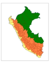
The climate of Peru
is very diverse, with a large variety of climate
s and microclimate
s, including 28 of the 32 world climates. Such a diversity is chiefly conditioned by the presence of the Andes mountains and the cold Humboldt Current
.
In general, the climate on the coast is subtropical
with very little rain
fall. The Andes mountains observe a cool-to-cold climate with rainy summer
s and very dry winter
s (Köppen climate classification
). The eastern lowlands present an Equatorial climate with hot weather and rain distributed all year long.
north of 5°S (thus, very close to the equator) to a climate which is a bit like the Mediterranean (Köppen Csb) climate with an important difference. The winter, although cloudy, cool and very humid, does not have sufficient rainfall to be considered a Köppen C climate.
The coast is chiefly determined by the influence of the cold Humboldt Current
, which runs The northern coast's (3°S–6°S) temperature extremes range from 14 to 38 °C (57.2 to 100.4 °F). Summers are characterized by hot, humid and sunny conditions, with occasional afternoon and nocturnal rainshowers. The farther north, the less arid, due to the Humboldt Current getting less cold as it nears the Equator. Thus, the Tumbes Region
, bordering Ecuador
, is the only coastal one with regular seasonal precipitation.
Summer rainfall totals rarely exceed 200 mm (7.9 in), save for severe El Niño events, which can provoke major floodings, with precipitations which can be as high as 4000 mm (157.5 in), especially in the readings observed over the entire Peruvian coast; the aforementioned Tumbes region and Piura
are the hottest. Winter is characterized by warm yet comfortable conditions and absence of rain.
Winter is characterized by overcast, cool and damp conditions, which keep daytime temperatures cool. Strictly by the coast and a few kilometers inland, winter is determined by an almost permanent layer of fog, which creates garua, a particular mist own to coastal Peru and Chile. In those areas located right by the ocean, the so-called 'rainy season' develops by late May and comes to an end by mid October. Precipitation occurs in the form of nocturnal-morning drizzle
and seasonal totals range between 10 and 150 mm (0.393700787401575 and 5.9 in). Winter precipitation favors the development of vegetation over particular coastal mountain ranges known as "Lomas". The desert green-up peaks between July and early November.
Temperatures range from 14 – at night and 19 – during the day. Winter highs oscillate between 15 and 21 °C (59 and 69.8 °F) and the lows between 8 and 15 °C (46.4 and 59 °F). Several weeks of persistent overcast skies and highs below 19 °C (66.2 °F) are not uncommon between July and September.
Some representative weather station
averages:
) exhibits the largest diversity among the country. Temperature is inversely proportional to altitude, varying from temperate (annual average of 18 °C (64.4 °F)) in the low-lying valleys to frigid (annual average below 0 °C (32 °F)) in the highest elevations
. The maximum temperature is often steady throughout the year, the low varying due to the presence of clouds in the rainy season, which help keeping to some extent the daytime heat during the night. In the absence of clouds, nights are much colder.
Precipitation varies in different scales and has a marked seasonality. The rainy season
starts in September but peaks between January and March, whereas the May–August period is characterized by strong insolation
, very dry conditions and cold night
s and morning
s, which is almost the exact reverse, in terms of insolation, to the coast climate. There is a marked southwest-northeast rainfall gradient with the driest conditions (200–500 mm (7.9–19.7 in)/year) along the southwestern Andes, and the wettest conditions along the eastern slopes (>1000 mm (39.4 in)/year). Upon the interaction between the topography and the mean flow, some regions immediately east of the Andes can receive as much as 10000 mm (393.7 in)/year. Rainfall is also larger over mountain ranges than over valley floors, since most of the rainfall occurs in the form of afternoon convective storms. Lakes also modulate the distribution and rainfall amounts. Lake Titicaca
, for example, induces nocturnal convective storms that produce twice as much rainfall over the lake than over the surrounding terrain. Occasionally thunderstorm
s can be accompanied by frequent cloud to ground lightning
, strong wind
s and damaging hail
, especially during the onset of the rainy season and over higher elevations. Snow
fall is frequent above 5000 m (16,404 ft) during the rainy season, and occasional above 3800 m (12,467 ft) between May and August. It can get cold!
Some representative averages
. The climate of this region is hot and rainy most of the year. Temperatures oscillate between 18 – most of the year and rainfall varies between 1000 and 4000 mm (39.4 and 157.5 in) per year. South of 8°S, a short dry season occurs between June and August. Occasional cold surges that originate over Argentina
may lower the temperature to 10 –. These events occur 1–5 times per year between May and September.
Some representative averages:
reported over 13,500 cases of pneumonia
, and more than 60,000 cases of respiratory infections. The Adventist Development and Relief Agency
(ADRA) is distributing blankets and warm clothing. Whereas pneumonia cases resulting in death of infants (who are often underclothed, if not barefoot) are the norm during winter, the 2009 winter season was unusual in that it began 12 weeks earlier than usual. More than 80 of the deaths occurred in Puno
, Peru, one of the larger cities of the Altiplano
lying in the central Andes
. The children suffering from malnourishment are the population at greatest risk in an impoverished southern area of Peru lacking health care facilities.
Yehude Simon, presidential Cabinet Chief, reported that 27 million S/
or US$
9 million was allotted for Puno
and 23,230 vaccine doses were shipped out. Oscar Ugarte, the Health Minister reported that only 234 of these vaccines were administered. Carmen Vildoso, Minister of Women's Affairs is working at developing a program to create solar panel heated walls in residential homes to provide heating.
In June, Percy Zaga Bustinza, Director of Puno's Social Development reported that a new Pinaya health centre would be opening up and also a small hospital in Santa Lucia
. UNICEF would like action taken so that the deaths from the predictable cold weather can be prevented. As well preventative measures should be put in place so that the cold weather does not arise in an emergency situation anymore. School hours were modified for the children's school days so they are not out in the coldest part of the day. By the middle of June, livestock and crops had been adversely affected by the cold weather across 92000 hectares (227,337 acre) of land. In July 2009, a state of emergency
was declared by President of Peru Alan García Pérez
in 11 regions of Peru: Apurímac
, Arequipa
, Ayacucho
, Cusco
, Huancavelica
, Junín
, Lima
, Moquegua
, Pasco
, Puno
and Tacna
. The cold winter weather is expected to end in September.
Peru
Peru , officially the Republic of Peru , is a country in western South America. It is bordered on the north by Ecuador and Colombia, on the east by Brazil, on the southeast by Bolivia, on the south by Chile, and on the west by the Pacific Ocean....
is very diverse, with a large variety of climate
Climate
Climate encompasses the statistics of temperature, humidity, atmospheric pressure, wind, rainfall, atmospheric particle count and other meteorological elemental measurements in a given region over long periods...
s and microclimate
Microclimate
A microclimate is a local atmospheric zone where the climate differs from the surrounding area. The term may refer to areas as small as a few square feet or as large as many square miles...
s, including 28 of the 32 world climates. Such a diversity is chiefly conditioned by the presence of the Andes mountains and the cold Humboldt Current
Humboldt Current
The Humboldt Current , also known as the Peru Current, is a cold, low-salinity ocean current that flows north-westward along the west coast of South America from the southern tip of Chile to northern Peru. It is an eastern boundary current flowing in the direction of the equator, and can extend...
.
In general, the climate on the coast is subtropical
Subtropics
The subtropics are the geographical and climatical zone of the Earth immediately north and south of the tropical zone, which is bounded by the Tropic of Cancer and the Tropic of Capricorn, at latitudes 23.5°N and 23.5°S...
with very little rain
Rain
Rain is liquid precipitation, as opposed to non-liquid kinds of precipitation such as snow, hail and sleet. Rain requires the presence of a thick layer of the atmosphere to have temperatures above the melting point of water near and above the Earth's surface...
fall. The Andes mountains observe a cool-to-cold climate with rainy summer
Summer
Summer is the warmest of the four temperate seasons, between spring and autumn. At the summer solstice, the days are longest and the nights are shortest, with day-length decreasing as the season progresses after the solstice...
s and very dry winter
Winter
Winter is the coldest season of the year in temperate climates, between autumn and spring. At the winter solstice, the days are shortest and the nights are longest, with days lengthening as the season progresses after the solstice.-Meteorology:...
s (Köppen climate classification
Köppen climate classification
The Köppen climate classification is one of the most widely used climate classification systems. It was first published by Crimea German climatologist Wladimir Köppen in 1884, with several later modifications by Köppen himself, notably in 1918 and 1936...
). The eastern lowlands present an Equatorial climate with hot weather and rain distributed all year long.
Pacific coast
The climate of the coast ranges from warm-semiaridSemi-arid
A semi-arid climate or steppe climate describes climatic regions that receive precipitation below potential evapotranspiration, but not extremely...
north of 5°S (thus, very close to the equator) to a climate which is a bit like the Mediterranean (Köppen Csb) climate with an important difference. The winter, although cloudy, cool and very humid, does not have sufficient rainfall to be considered a Köppen C climate.
The coast is chiefly determined by the influence of the cold Humboldt Current
Humboldt Current
The Humboldt Current , also known as the Peru Current, is a cold, low-salinity ocean current that flows north-westward along the west coast of South America from the southern tip of Chile to northern Peru. It is an eastern boundary current flowing in the direction of the equator, and can extend...
, which runs The northern coast's (3°S–6°S) temperature extremes range from 14 to 38 °C (57.2 to 100.4 °F). Summers are characterized by hot, humid and sunny conditions, with occasional afternoon and nocturnal rainshowers. The farther north, the less arid, due to the Humboldt Current getting less cold as it nears the Equator. Thus, the Tumbes Region
Tumbes Region
Tumbes is a coastal region in northwestern Peru and southwestern Ecuador. Due to the region's location near the Equator it has a warm climate, with beaches that are considered among the finest in Peru...
, bordering Ecuador
Ecuador
Ecuador , officially the Republic of Ecuador is a representative democratic republic in South America, bordered by Colombia on the north, Peru on the east and south, and by the Pacific Ocean to the west. It is one of only two countries in South America, along with Chile, that do not have a border...
, is the only coastal one with regular seasonal precipitation.
Summer rainfall totals rarely exceed 200 mm (7.9 in), save for severe El Niño events, which can provoke major floodings, with precipitations which can be as high as 4000 mm (157.5 in), especially in the readings observed over the entire Peruvian coast; the aforementioned Tumbes region and Piura
Piura Region
Piura is a coastal region in northwestern Peru. The region's capital is Piura and its largest port cities, Paita and Talara, are also among the most important in Peru...
are the hottest. Winter is characterized by warm yet comfortable conditions and absence of rain.
Central and southern coast
In the central and southern coasts (south of 6°S) temperature ranges from 8 to 29 °C (46.4 to 84.2 °F) and rainfall is scarce with annual totals are 150 mm. Summer is characterized by warm, moist and sunny conditions with lows between 18 and 22 °C (64.4 and 71.6 °F) and highs between 24 and 29 °C (75.2 and 84.2 °F). Temperatures over 29 °C (84.2 °F) are commonly observed less than 10 days per year except at the Ica deserts where summer highs can sometimes reach 35 °C (95 °F). Little or no rainfall occurs during the summer. Very rare rainfall events are produced by the leftovers of Andean convection and occur during the night. Summer rainfall totals are generally less than 10 mm (0.393700787401575 in).Winter is characterized by overcast, cool and damp conditions, which keep daytime temperatures cool. Strictly by the coast and a few kilometers inland, winter is determined by an almost permanent layer of fog, which creates garua, a particular mist own to coastal Peru and Chile. In those areas located right by the ocean, the so-called 'rainy season' develops by late May and comes to an end by mid October. Precipitation occurs in the form of nocturnal-morning drizzle
Drizzle
Drizzle is a light rain precipitation consisting of liquid water drops smaller than those of rain, and generally smaller than 0.5 mm in diameter. Drizzle is normally produced by low stratiform clouds and stratocumulus clouds. Precipitation rates due to drizzle are on the order of a millimetre...
and seasonal totals range between 10 and 150 mm (0.393700787401575 and 5.9 in). Winter precipitation favors the development of vegetation over particular coastal mountain ranges known as "Lomas". The desert green-up peaks between July and early November.
Temperatures range from 14 – at night and 19 – during the day. Winter highs oscillate between 15 and 21 °C (59 and 69.8 °F) and the lows between 8 and 15 °C (46.4 and 59 °F). Several weeks of persistent overcast skies and highs below 19 °C (66.2 °F) are not uncommon between July and September.
Some representative weather station
Weather station
A weather station is a facility, either on land or sea, with instruments and equipment for observing atmospheric conditions to provide information for weather forecasts and to study the weather and climate. The measurements taken include temperature, barometric pressure, humidity, wind speed, wind...
averages:
- PiuraPiuraPiura is a city in northwestern Peru. It is the capital of the Piura Region and the Piura Province. The population is 377,496.It was here that Spanish Conqueror Francisco Pizarro founded the third Spanish city in South America and first in Peru, San Miguel de Piura, in July 1532...
(north); 55 m (180 ft); annual mean temperature 24.4 °C (75.9 °F); annual mean precipitation 72 mm (2.8 in) Climate type BWh (hot desertDesertA desert is a landscape or region that receives an extremely low amount of precipitation, less than enough to support growth of most plants. Most deserts have an average annual precipitation of less than...
). - LimaLimaLima is the capital and the largest city of Peru. It is located in the valleys of the Chillón, Rímac and Lurín rivers, in the central part of the country, on a desert coast overlooking the Pacific Ocean. Together with the seaport of Callao, it forms a contiguous urban area known as the Lima...
, (central); 30 m (98 ft); annual mean temperature 19.2 °C (66.6 °F); annual 15 mm (0.590551181102362 in), Climate type BWk (temperate desert, cold Humboldt CurrentHumboldt CurrentThe Humboldt Current , also known as the Peru Current, is a cold, low-salinity ocean current that flows north-westward along the west coast of South America from the southern tip of Chile to northern Peru. It is an eastern boundary current flowing in the direction of the equator, and can extend...
generates fog). - Lomas de LachayLomas de LachayThe Lomas de Lachay is a national reserve in the desert foothills of Huaura Province in Lima region of Peru. The reserve is located north from the capital Lima and features a unique mist-fed ecosystem of wild plant and animal species...
, Huaral ProvinceHuaral ProvinceThe Huaral Province is one of the nine provinces in the Lima Region of Peru. It was created by Law No. 21488 on May 11, 1976 by president Francisco Morales Bermúdez out of eight districts of the Canta Province and four of the Huaura Province...
in LimaLimaLima is the capital and the largest city of Peru. It is located in the valleys of the Chillón, Rímac and Lurín rivers, in the central part of the country, on a desert coast overlooking the Pacific Ocean. Together with the seaport of Callao, it forms a contiguous urban area known as the Lima...
, a unique mist-fed ecosystem.
Andean highlands
The Peruvian Andes (clima de Sierra in SpanishSpanish language
Spanish , also known as Castilian , is a Romance language in the Ibero-Romance group that evolved from several languages and dialects in central-northern Iberia around the 9th century and gradually spread with the expansion of the Kingdom of Castile into central and southern Iberia during the...
) exhibits the largest diversity among the country. Temperature is inversely proportional to altitude, varying from temperate (annual average of 18 °C (64.4 °F)) in the low-lying valleys to frigid (annual average below 0 °C (32 °F)) in the highest elevations
Alpine climate
Alpine climate is the average weather for a region above the tree line. This climate is also referred to as mountain climate or highland climate....
. The maximum temperature is often steady throughout the year, the low varying due to the presence of clouds in the rainy season, which help keeping to some extent the daytime heat during the night. In the absence of clouds, nights are much colder.
Precipitation varies in different scales and has a marked seasonality. The rainy season
Wet season
The the wet season, or rainy season, is the time of year, covering one or more months, when most of the average annual rainfall in a region occurs. The term green season is also sometimes used as a euphemism by tourist authorities. Areas with wet seasons are dispersed across portions of the...
starts in September but peaks between January and March, whereas the May–August period is characterized by strong insolation
Insolation
Insolation is a measure of solar radiation energy received on a given surface area in a given time. It is commonly expressed as average irradiance in watts per square meter or kilowatt-hours per square meter per day...
, very dry conditions and cold night
Night
Night or nighttime is the period of time when the sun is below the horizon. This occurs after dusk. The opposite of night is day...
s and morning
Morning
The word morning originally referred to the sunrise. Morning precedes midday, afternoon, and night in the sequence of a day.Morning is the part of the day usually reckoned from dawn to noon...
s, which is almost the exact reverse, in terms of insolation, to the coast climate. There is a marked southwest-northeast rainfall gradient with the driest conditions (200–500 mm (7.9–19.7 in)/year) along the southwestern Andes, and the wettest conditions along the eastern slopes (>1000 mm (39.4 in)/year). Upon the interaction between the topography and the mean flow, some regions immediately east of the Andes can receive as much as 10000 mm (393.7 in)/year. Rainfall is also larger over mountain ranges than over valley floors, since most of the rainfall occurs in the form of afternoon convective storms. Lakes also modulate the distribution and rainfall amounts. Lake Titicaca
Lake Titicaca
Lake Titicaca is a lake located on the border of Peru and Bolivia. It sits 3,811 m above sea level, making it the highest commercially navigable lake in the world...
, for example, induces nocturnal convective storms that produce twice as much rainfall over the lake than over the surrounding terrain. Occasionally thunderstorm
Thunderstorm
A thunderstorm, also known as an electrical storm, a lightning storm, thundershower or simply a storm is a form of weather characterized by the presence of lightning and its acoustic effect on the Earth's atmosphere known as thunder. The meteorologically assigned cloud type associated with the...
s can be accompanied by frequent cloud to ground lightning
Lightning
Lightning is an atmospheric electrostatic discharge accompanied by thunder, which typically occurs during thunderstorms, and sometimes during volcanic eruptions or dust storms...
, strong wind
Wind
Wind is the flow of gases on a large scale. On Earth, wind consists of the bulk movement of air. In outer space, solar wind is the movement of gases or charged particles from the sun through space, while planetary wind is the outgassing of light chemical elements from a planet's atmosphere into space...
s and damaging hail
Hail
Hail is a form of solid precipitation. It consists of balls or irregular lumps of ice, each of which is referred to as a hail stone. Hail stones on Earth consist mostly of water ice and measure between and in diameter, with the larger stones coming from severe thunderstorms...
, especially during the onset of the rainy season and over higher elevations. Snow
Snow
Snow is a form of precipitation within the Earth's atmosphere in the form of crystalline water ice, consisting of a multitude of snowflakes that fall from clouds. Since snow is composed of small ice particles, it is a granular material. It has an open and therefore soft structure, unless packed by...
fall is frequent above 5000 m (16,404 ft) during the rainy season, and occasional above 3800 m (12,467 ft) between May and August. It can get cold!
Some representative averages
- Chachapoyas, PeruChachapoyas, PeruIn this part of Peru, located in the eyebrow of the jungle, the climate is subtropical highland, described by the Köppen climate classification as Cwb, with an average temperature of 18 °C and an average relative humidity of 74 percent. However, in some areas the temperature can drop to 2 °C....
; 2435 m (7,989 ft); annual mean temperature 15.3 °C (59.5 °F); annual mean precipitation 796 mm (31.3 in), Climate type CwbOceanic climateAn oceanic climate, also called marine west coast climate, maritime climate, Cascadian climate and British climate for Köppen climate classification Cfb and subtropical highland for Köppen Cfb or Cwb, is a type of climate typically found along the west coasts at the middle latitudes of some of the...
. - CuzcoCuscoCusco , often spelled Cuzco , is a city in southeastern Peru, near the Urubamba Valley of the Andes mountain range. It is the capital of the Cusco Region as well as the Cuzco Province. In 2007, the city had a population of 358,935 which was triple the figure of 20 years ago...
, Peru; 3249 m (10,659 ft); annual mean temperature 12.5 °C (54.5 °F); annual mean precipitation 736 mm (29 in), Climate type CwbOceanic climateAn oceanic climate, also called marine west coast climate, maritime climate, Cascadian climate and British climate for Köppen climate classification Cfb and subtropical highland for Köppen Cfb or Cwb, is a type of climate typically found along the west coasts at the middle latitudes of some of the...
.
Eastern lowlands
The eastern lowlands are characterized by the Equatorial climate which feeds the Amazon RainforestAmazon Rainforest
The Amazon Rainforest , also known in English as Amazonia or the Amazon Jungle, is a moist broadleaf forest that covers most of the Amazon Basin of South America...
. The climate of this region is hot and rainy most of the year. Temperatures oscillate between 18 – most of the year and rainfall varies between 1000 and 4000 mm (39.4 and 157.5 in) per year. South of 8°S, a short dry season occurs between June and August. Occasional cold surges that originate over Argentina
Argentina
Argentina , officially the Argentine Republic , is the second largest country in South America by land area, after Brazil. It is constituted as a federation of 23 provinces and an autonomous city, Buenos Aires...
may lower the temperature to 10 –. These events occur 1–5 times per year between May and September.
Some representative averages:
- IquitosIquitosIquitos is the largest city in the Peruvian rainforest, with a population of 370,962. It is the capital of Loreto Region and Maynas Province.Located on the Amazon River, it is only above sea level, although it is more than from the mouth of the Amazon at Belém on the Atlantic Ocean...
, Peru; 126 m (413 ft), annual mean temperature 26.2 °C (79.2 °F); annual mean precipitation 2853 mm (112.3 in), Climate type Af. - YurimaguasYurimaguasYurimaguas is a thriving port-town in the Loreto Region of northeastern Peruvian Amazonia. Historically associated with Maynas Pais de los Maynas, the culturally diverse town is affectionately known as the "Pearl of the Huallaga"...
, Peru; 184 m (604 ft); annual mean temperature 26.9 °C (80.4 °F); annual mean precipitation 2047 mm (80.6 in), Climate type Af.
2009 winter
From April to July 2009, unusually cold weather resulted in the deaths of more than 250 children under the age of five. In June, there were 50,000 suffering from acute respiratory infections, and 4,851 with pneumonia. Between mid April and mid June, 61 children perished. The United Nations Population FundUnited Nations Population Fund
The United Nations Population Fund is a UN organization. The work of the UNFPA involves promotion of the right of every woman, man and child to enjoy a life of health and equal opportunity. This is done through major national and demographic surveys and with population censuses...
reported over 13,500 cases of pneumonia
Pneumonia
Pneumonia is an inflammatory condition of the lung—especially affecting the microscopic air sacs —associated with fever, chest symptoms, and a lack of air space on a chest X-ray. Pneumonia is typically caused by an infection but there are a number of other causes...
, and more than 60,000 cases of respiratory infections. The Adventist Development and Relief Agency
Adventist Development and Relief Agency
The Adventist Development and Relief Agency International is a humanitarian agency operated by the Seventh-day Adventist Church for the purpose of providing individual and community development and disaster relief...
(ADRA) is distributing blankets and warm clothing. Whereas pneumonia cases resulting in death of infants (who are often underclothed, if not barefoot) are the norm during winter, the 2009 winter season was unusual in that it began 12 weeks earlier than usual. More than 80 of the deaths occurred in Puno
Puno
Puno is a city in southeastern Peru, located on the shore of Lake Titicaca. It is the capital city of the Puno Region and the Puno Province with a population of approximately 100,000. The city was established in 1668 by viceroy Pedro Antonio Fernández de Castro as capital of the province of...
, Peru, one of the larger cities of the Altiplano
Altiplano
The Altiplano , in west-central South America, where the Andes are at their widest, is the most extensive area of high plateau on Earth outside of Tibet...
lying in the central Andes
Andes
The Andes is the world's longest continental mountain range. It is a continual range of highlands along the western coast of South America. This range is about long, about to wide , and of an average height of about .Along its length, the Andes is split into several ranges, which are separated...
. The children suffering from malnourishment are the population at greatest risk in an impoverished southern area of Peru lacking health care facilities.
Yehude Simon, presidential Cabinet Chief, reported that 27 million S/
Peruvian nuevo sol
The nuevo sol plural: nuevos soles; currency sign: S/.) is the currency of Peru. It is subdivided into 100 cents, called céntimos in Spanish. The ISO 4217 currency code is PEN. It is most commonly referred to just as sol...
or US$
United States dollar
The United States dollar , also referred to as the American dollar, is the official currency of the United States of America. It is divided into 100 smaller units called cents or pennies....
9 million was allotted for Puno
Puno
Puno is a city in southeastern Peru, located on the shore of Lake Titicaca. It is the capital city of the Puno Region and the Puno Province with a population of approximately 100,000. The city was established in 1668 by viceroy Pedro Antonio Fernández de Castro as capital of the province of...
and 23,230 vaccine doses were shipped out. Oscar Ugarte, the Health Minister reported that only 234 of these vaccines were administered. Carmen Vildoso, Minister of Women's Affairs is working at developing a program to create solar panel heated walls in residential homes to provide heating.
In June, Percy Zaga Bustinza, Director of Puno's Social Development reported that a new Pinaya health centre would be opening up and also a small hospital in Santa Lucia
Santa Lucia
Santa Lucia is a traditional Neapolitan song. It was transcribed by Teodoro Cottrau and published by the Cottrau firm, as a "barcarolla", at Naples in 1849. Cottrau translated it from Napuletano into Italian during the first stage of the Risorgimento, the first Neapolitan song to be given Italian...
. UNICEF would like action taken so that the deaths from the predictable cold weather can be prevented. As well preventative measures should be put in place so that the cold weather does not arise in an emergency situation anymore. School hours were modified for the children's school days so they are not out in the coldest part of the day. By the middle of June, livestock and crops had been adversely affected by the cold weather across 92000 hectares (227,337 acre) of land. In July 2009, a state of emergency
State of emergency
A state of emergency is a governmental declaration that may suspend some normal functions of the executive, legislative and judicial powers, alert citizens to change their normal behaviours, or order government agencies to implement emergency preparedness plans. It can also be used as a rationale...
was declared by President of Peru Alan García Pérez
Alan García Pérez
Alan Gabriel Ludwig García Pérez was the President of Peru, having won the 2006 elections on 4 June 2006 in a run-off against Union for Peru candidate Ollanta Humala. He is the leader of the APRA and the only party member ever to have served as President of Peru. He served a first term as...
in 11 regions of Peru: Apurímac
Apurímac Region
Apurímac is a region in southern-central Peru. It is bordered on the east by the Cusco Region, on the west by the Ayacucho Region, and on the south by the Arequipa and Ayacucho regions...
, Arequipa
Arequipa Region
Arequipa is a region in southwestern Peru. It is bordered by the Ica, Ayacucho, Apurímac and Cusco regions on the north; the Puno Region on the east; the Moquegua Region on the south; and the Pacific Ocean on the west...
, Ayacucho
Ayacucho Region
Ayacucho is a region of Peru, located in the south-central Andes of the country. Its capital is the city of Ayacucho. The region was one of the hardest hit by terrorism during the 1980s during the guerrilla war waged by Shining Path known as the internal conflict in Peru.A referendum was held on...
, Cusco
Cusco Region
Cusco is a region in Peru. It is bordered by the Ucayali Region on the north; the Madre de Dios and Puno regions on the east; the Arequipa Region on the south; and the Apurímac, Ayacucho and Junín regions on the west...
, Huancavelica
Huancavelica Region
Huancavelica is a region in Peru. Area: 22,131.47 km². Population: 447,054 . The capital is the city of Huancavelica.It is bordered by Lima Region and Ica in the west, Junín in the north, and Ayacucho in the east....
, Junín
Junín Region
Junín is a region in the central highlands and westernmost Amazonia of Peru. Its capital is Huancayo.-Geography:The region has a very heterogeneous topography. The western cordillera located near the border with the Lima Region, has snowy and ice covered peaks. On the east, there are high glacier...
, Lima
Lima Region
Lima Region, also known as Lima Provincias, is one of twenty-five regions of Peru. Located in the central coast of the country, its regional seat is Huacho....
, Moquegua
Moquegua Region
Moquegua is a small department in southern Peru that extends from the coast to the highlands. The region's name is of Quechua origin and means "quiet place". The regional capital is the city of Moquegua, but the port city of Ilo is more commercially active....
, Pasco
Pasco Region
Pasco is a region in central Peru. Its capital is Cerro de Pasco.-Political division:The region is divided into 3 provinces , which are composed of 28 districts .-Provinces:...
, Puno
Puno Region
Puno is a region in southeastern Peru. It is bordered by Bolivia on the east, the Madre de Dios Region on the north, the Cusco and Arequipa regions on the west, the Moquegua Region on the southwest, and the Tacna Region on the south...
and Tacna
Tacna Region
Tacna is the southernmost region in Peru. Its name originates from the Quechua words taka and na , which would mean "a place to hit". This expression is thought to be related to the Quechua conquest of the Aymara people...
. The cold winter weather is expected to end in September.