

Climate of Antarctica
Encyclopedia
Climate
Climate encompasses the statistics of temperature, humidity, atmospheric pressure, wind, rainfall, atmospheric particle count and other meteorological elemental measurements in a given region over long periods...
of Antarctica is the coldest on the whole of Earth. Antarctica has the lowest naturally occurring temperature
Temperature
Temperature is a physical property of matter that quantitatively expresses the common notions of hot and cold. Objects of low temperature are cold, while various degrees of higher temperatures are referred to as warm or hot...
ever recorded on the ground on Earth: −89.2 °C (−128.6 °F) at Vostok Station. It is also extremely dry (technically a desert
Desert
A desert is a landscape or region that receives an extremely low amount of precipitation, less than enough to support growth of most plants. Most deserts have an average annual precipitation of less than...
), averaging 166 mm (6.5 in) of precipitation
Precipitation (meteorology)
In meteorology, precipitation In meteorology, precipitation In meteorology, precipitation (also known as one of the classes of hydrometeors, which are atmospheric water phenomena is any product of the condensation of atmospheric water vapor that falls under gravity. The main forms of precipitation...
per year. Even so, on most parts of the continent the snow rarely melts and is eventually compressed to become the glacial
Glacier
A glacier is a large persistent body of ice that forms where the accumulation of snow exceeds its ablation over many years, often centuries. At least 0.1 km² in area and 50 m thick, but often much larger, a glacier slowly deforms and flows due to stresses induced by its weight...
ice that makes up the ice sheet
Ice sheet
An ice sheet is a mass of glacier ice that covers surrounding terrain and is greater than 50,000 km² , thus also known as continental glacier...
. Weather front
Weather front
A weather front is a boundary separating two masses of air of different densities, and is the principal cause of meteorological phenomena. In surface weather analyses, fronts are depicted using various colored lines and symbols, depending on the type of front...
s rarely penetrate far into the continent. Most of Antarctica has an ice cap
Ice cap
An ice cap is an ice mass that covers less than 50 000 km² of land area . Masses of ice covering more than 50 000 km² are termed an ice sheet....
climate (Köppen EF) with very cold, generally extremely dry weather throughout the year and no month averaging above 0 °C (32 °F). Some fringe coastal areas have a polar climate
Polar climate
Regions with a polar climate are characterized by a lack of warm summers . Regions with polar climate cover over 20% of the Earth. The sun shines 24 hours in the summer, and barely ever shines at all in the winter...
(Köppen ET) with a short summer averaging above freezing, and much higher precipitation.
Temperature
The lowest naturally occurring temperature on Earth was −89.2°C (−128.6°F); recorded on Thursday, July 21, 1983 at Vostok Station. For comparison, this is colder than subliming dry iceDry ice
Dry ice, sometimes referred to as "Cardice" or as "card ice" , is the solid form of carbon dioxide. It is used primarily as a cooling agent. Its advantages include lower temperature than that of water ice and not leaving any residue...
. The highest temperature ever recorded in Antarctica was 14.6°C (58.3°F) in two places, Hope Bay
Hope Bay
Hope Bay on Trinity Peninsula, is long and wide, indenting the tip of Antarctic Peninsula and opening on Antarctic Sound....
and Vanda Station
Vanda Station
Vanda Station was an Antarctic research base in the western highlands of the Ross Dependency, specifically on the shore of Lake Vanda, at the mouth of Onyx River, in the Wright Valley...
, on January 5, 1974. The mean annual temperature of the interior is −57°C (−70°F). The coast is warmer. Monthly means at McMurdo Station
McMurdo Station
McMurdo Station is a U.S. Antarctic research center located on the southern tip of Ross Island, which is in the New Zealand-claimed Ross Dependency on the shore of McMurdo Sound in Antarctica. It is operated by the United States through the United States Antarctic Program, a branch of the National...
range from −28°C (−18.4°F) in August to −3°C (26.6°F) in January. At the South Pole
South Pole
The South Pole, also known as the Geographic South Pole or Terrestrial South Pole, is one of the two points where the Earth's axis of rotation intersects its surface. It is the southernmost point on the surface of the Earth and lies on the opposite side of the Earth from the North Pole...
, the highest temperature recorded was −14°C (7°F). Along the Antarctic Peninsula
Antarctic Peninsula
The Antarctic Peninsula is the northernmost part of the mainland of Antarctica. It extends from a line between Cape Adams and a point on the mainland south of Eklund Islands....
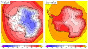
, temperatures as high as 15°C (59°F) have been recorded, though the summer temperature is usually around 2°C (36°F). Severe low temperatures vary with latitude, elevation, and distance from the ocean. East Antarctica is colder than West Antarctica because of its higher elevation. The Antarctic Peninsula has the most moderate climate. Higher temperatures occur in January along the coast and average slightly below freezing.
Precipitation
Precipitation (meteorology)
In meteorology, precipitation In meteorology, precipitation In meteorology, precipitation (also known as one of the classes of hydrometeors, which are atmospheric water phenomena is any product of the condensation of atmospheric water vapor that falls under gravity. The main forms of precipitation...
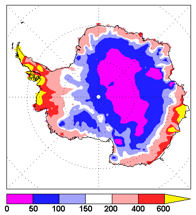
in Antarctica, averaged over the entire continent, is about 166 mm (6.5 in) per year (Vaughan et al., J Climate, 1999). The actual rates vary widely, from high values over the Peninsula
Antarctic Peninsula
The Antarctic Peninsula is the northernmost part of the mainland of Antarctica. It extends from a line between Cape Adams and a point on the mainland south of Eklund Islands....
(meters/yards per year) to very low values (as little as 50 mm (2 in) per year) in the high interior. Areas that receive less than 250 mm (10 in) of precipitation per year are classified as desert
Desert
A desert is a landscape or region that receives an extremely low amount of precipitation, less than enough to support growth of most plants. Most deserts have an average annual precipitation of less than...
s. Almost all Antarctic precipitation falls as snow
Snow
Snow is a form of precipitation within the Earth's atmosphere in the form of crystalline water ice, consisting of a multitude of snowflakes that fall from clouds. Since snow is composed of small ice particles, it is a granular material. It has an open and therefore soft structure, unless packed by...
. Note that the quoted precipitation is a measure of its equivalence to water, rather than being the actual depth of snow. The air in Antarctica is also very dry. The low temperatures result in a very low absolute humidity
Humidity
Humidity is a term for the amount of water vapor in the air, and can refer to any one of several measurements of humidity. Formally, humid air is not "moist air" but a mixture of water vapor and other constituents of air, and humidity is defined in terms of the water content of this mixture,...
, which means that dry skin and cracked lips are a continual problem for scientists and expeditioners working in the continent.
Weather condition classification
The weather in Antarctica can be highly variable, and the weather conditions can often change dramatically in short periods of time. There are three classifications for describing weather conditions in Antarctica. At least one of the following criteria must be met for each category.Condition 1
- Windspeed over 55 knots (60 miles per hour)
- Visibility less than 100 feet (30 meters)
- Wind chill below −100 °F (−73 °C)
- Description: Dangerous conditions; outside travel is not permitted.
Condition 2
- Windspeed of 48 to 55 knots (55 to 63 miles per hour)
- Visibility 1/4 of a mile to 100 feet (402 to 30 meters)
- Wind chill of −75 °F (−60 °C) to −100 °F (−73 °C)
- Description: Unpleasant conditions; outside travel is permitted but not recommended.
Condition 3
- Windspeed below 48 knots (55 miles per hour)
- Visibility greater than 1/4 of a mile (402 meters)
- Wind chill above −75 °F (−60 °C)
- Description: Pleasant conditions; all outside travel is permitted.
Ice cover
Nearly all of Antarctica is covered by an ice sheetIce sheet
An ice sheet is a mass of glacier ice that covers surrounding terrain and is greater than 50,000 km² , thus also known as continental glacier...
that is, on average, at least 1.6 kilometres thick. Antarctica contains 90% of the world's ice and more than 70% of its fresh water. If all the land-ice covering Antarctica were to melt — around 30 million cubic kilometres of ice — the seas would rise by over 60 metres. This is, however, very unlikely within the next few centuries. The Antarctic is so cold that even with increases of a few degrees, temperatures would generally remain below the melting point of ice. Warmer temperatures are expected to lead to more snow, which would increase the amount of ice in Antarctica, offsetting approximately one third of the expected sea level rise from thermal expansion of the oceans.
During a recent decade, East Antarctica thickened at an average rate of about 1.8 centimetres per year while West Antarctica showed an overall thinning of 0.9 centimetres per year (Davis et al., Science 2005) . For the contribution of Antarctica to present and future sea level
Future sea level
The rate of global mean sea-level rise has accelerated compared to the mean of the 20th century , but the rate of rise is locally variable. Factors contributing to SLR include decreased global ice volume and warming of the ocean. On Greenland, the deficiency between annual ice gained and lost...
change, see sea level rise. Because ice flows, albeit slowly, the ice within the ice sheet is younger than the age of the sheet itself.
| Surface | Area (km²) |
Percent | Mean ice thickness (m) |
Volume (km³) |
Percent |
|---|---|---|---|---|---|
| Inland ice sheet | 11,965,700 | 85.97 | 2,450 | 29,324,700 | 97.39 |
| Ice shelves | 1,541,710 | 11.08 | 475 | 731,900 | 2.43 |
| Ice rise Ice rise An ice rise is a clearly defined elevation of the otherwise totally flat ice shelf, typically dome-shaped and rising 100 to 200 meters above the surrounding ice shelf. An ice rise forms where the ice shelf touches the rocky seabed because of an elevation in the seabed that remains below sea level... s |
78,970 | .57 | 670 | 53,100 | .18 |
| Glacier ice (total) | 13,586,380 | 2,160 | 30,109,800¹ | ||
| Rock outcrop | 331,690 | 2.38 | |||
| Antarctica (total) | 13,918,070 | 100.00 | 2,160 | 30,109,800¹ | 100.00 |
| ¹The total ice volume is different from the sum of the component parts because individual figures have been rounded. | |||||
| Region | Area (km²) |
Mean ice thickness (m) |
Volume (km³) |
|---|---|---|---|
| East Antarctica | |||
| Inland ice | 9,855,570 | 2,630 | 25,920,100 |
| Ice shelves | 293,510 | 400 | 117,400 |
| Ice rises | 4,090 | 400 | 1,600 |
| West Antarctica (excluding Antarctic Peninsula) | |||
| Inland ice sheet West Antarctic Ice Sheet The West Antarctic Ice Sheet is the segment of the continental ice sheet that covers West Antarctica, the portion of Antarctica on the side of the Transantarctic Mountains which lies in the Western Hemisphere. The WAIS is classified as a marine-based ice sheet, meaning that its bed lies well... |
1,809,760 | 1,780 | 3,221,400 |
| Ice shelves | 104,860 | 375 | 39,300 |
| Ice rises | 3,550 | 375 | 1,300 |
| Antarctic Peninsula Antarctic Peninsula The Antarctic Peninsula is the northernmost part of the mainland of Antarctica. It extends from a line between Cape Adams and a point on the mainland south of Eklund Islands.... |
|||
| Inland ice sheet | 300,380 | 610 | 183,200 |
| Ice shelves | 144,750 | 300 | 43,400 |
| Ice rises | 1,570 | 300 | 500 |
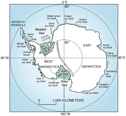
| Ross Ice Shelf Ross Ice Shelf The Ross Ice Shelf is the largest ice shelf of Antarctica . It is several hundred metres thick. The nearly vertical ice front to the open sea is more than 600 km long, and between 15 and 50 metres high above the water surface... |
|||
| Ice shelf | 525,840 | 427 | 224,500 |
| Ice rises | 10,320 | 500 | 5,100 |
| Filchner-Ronne Ice Shelf Filchner-Ronne Ice Shelf The Filchner-Ronne Ice Shelf, also known as Ronne-Filchner Ice Shelf, is an Antarctic ice shelf bordering the Weddell Sea.-Description:... |
|||
| Ice shelf | 472,760 | 650 | 307,300 |
| Ice rises | 59,440 | 750 | 44,600 |
Ice shelves
Ice shelf
An ice shelf is a thick, floating platform of ice that forms where a glacier or ice sheet flows down to a coastline and onto the ocean surface. Ice shelves are only found in Antarctica, Greenland and Canada. The boundary between the floating ice shelf and the grounded ice that feeds it is called...
(floating ice sheet) or ice walls (grounded ice). Melting or breakup of floating shelf ice does not affect global sea levels, and happens regularly as shelves grow. Known changes in coastline ice:
- Around the Antarctic Peninsula:
- 1936–1989: Wordie Ice ShelfWordie Ice ShelfThe Wordie Ice Shelf was a confluent glacier projecting as an ice shelf into the SE part of Marguerite Bay between Cape Berteaux and Mount Edgell, along the western coast of Antarctic Peninsula....
significantly reduced in size. - 1995: Prince Gustav ChannelPrince Gustav ChannelThe Prince Gustav Channel was named in 1903 after Crown Prince Gustav of Sweden by Otto Nordenskiöld of the Swedish Antarctic Expedition.The channel is bounded on the west by the Antarctic Peninsula and on the east by James Ross Island...
no longer blocked by ice. Last open from about 1900 years ago to 6500 years ago, probably due to warmth during the Holocene Climatic OptimumHolocene climatic optimumThe Holocene Climate Optimum was a warm period during roughly the interval 9,000 to 5,000 years B.P.. This event has also been known by many other names, including: Hypsithermal, Altithermal, Climatic Optimum, Holocene Optimum, Holocene Thermal Maximum, and Holocene Megathermal.This warm period...
. - Parts of the Larsen Ice ShelfLarsen Ice ShelfThe Larsen Ice Shelf is a long, fringing ice shelf in the northwest part of the Weddell Sea, extending along the east coast of Antarctic Peninsula from Cape Longing to the area just southward of Hearst Island...
broke up in recent decades.- 1995: The Larsen A ice shelf disintegrated in January 1995.
- 2001: 3,250 km² of the Larsen B ice shelf disintegrated in February 2001. It had been gradually retreating before the breakup event.
- 1936–1989: Wordie Ice Shelf
The George VI Ice Shelf
George VI Ice Shelf
The George VI Ice Shelf is an extensive ice shelf that occupies George VI Sound between Alexander Island and Palmer Land in Antarctica. The ice shelf extends from Ronne Entrance, at the southwest end of the sound, to Niznik Island, about south of the north entrance between Cape Brown and Cape...
, which may be on the brink of instability, has probably existed for approximately 8000 years, after melting 1500 years earlier. Warm ocean currents may have been the cause of the melting. The idea that it was warmer in Antarctica 10,000 years ago is supported by ice cores, though the timing is not quite right.
Climate change
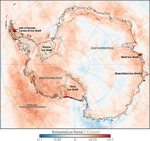
The West Antarctic ice sheet has warmed by more than 0.1°C/decade in the last 50 years, and is strongest in winter and spring. Although this is partly offset by fall cooling in East Antarctica, this effect is restricted to the 1980s and 1990s.
The British Antarctic Survey
British Antarctic Survey
The British Antarctic Survey is the United Kingdom's national Antarctic operation and has an active role in Antarctic affairs. BAS is part of the Natural Environment Research Council and has over 400 staff. It operates five research stations, two ships and five aircraft in and around Antarctica....
, which has undertaken the majority of Britain's scientific research in the area, has the following positions: http://www.antarctica.ac.uk/Key_Topics/Climate_Change/Climate_Change_Position.html
- Ice makes polar climate sensitive by introducing a strong positive feedbackPositive feedbackPositive feedback is a process in which the effects of a small disturbance on a system include an increase in the magnitude of the perturbation. That is, A produces more of B which in turn produces more of A. In contrast, a system that responds to a perturbation in a way that reduces its effect is...
loop. - Melting of continental Antarctic ice could contribute to global sea level rise.
- Climate modelClimate modelClimate models use quantitative methods to simulate the interactions of the atmosphere, oceans, land surface, and ice. They are used for a variety of purposes from study of the dynamics of the climate system to projections of future climate...
s predict more snowfall than ice melting during the next 50 years, but models are not good enough for them to be confident about the prediction. - Antarctica seems to be both warming around the edges and cooling at the center at the same time. Thus it is not possible to say whether it is warming or cooling overall.
- There is no evidence for a decline in overall Antarctic sea ice extent.
- The central and southern parts of the west coast of the Antarctic Peninsula have warmed by nearly 3°C. The cause is not known.
- Changes have occurred in the upper atmosphere over Antarctica.
Ultraviolet
Ultraviolet light is electromagnetic radiation with a wavelength shorter than that of visible light, but longer than X-rays, in the range 10 nm to 400 nm, and energies from 3 eV to 124 eV...
-absorbing ozone
Ozone
Ozone , or trioxygen, is a triatomic molecule, consisting of three oxygen atoms. It is an allotrope of oxygen that is much less stable than the diatomic allotrope...
may have cooled the stratosphere
Stratosphere
The stratosphere is the second major layer of Earth's atmosphere, just above the troposphere, and below the mesosphere. It is stratified in temperature, with warmer layers higher up and cooler layers farther down. This is in contrast to the troposphere near the Earth's surface, which is cooler...
and strengthened the polar vortex
Polar vortex
A polar vortex is a persistent, large-scale cyclone located near one or both of a planet's geographical poles. On Earth, the polar vortices are located in the middle and upper troposphere and the stratosphere...
, a pattern of spinning winds around the South Pole. The vortex acts like an atmospheric barrier, preventing warmer, coastal air from moving in to the continent's interior. A stronger polar vortex might explain the cooling trend in the interior of Antarctica. http://earthobservatory.nasa.gov/Newsroom/NewImages/images.php3?img_id=17257
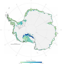
In their latest study (September 20, 2007) NASA researchers have confirmed that Antarctic snow is melting farther inland from the coast over time, melting at higher altitudes than ever and increasingly melting on Antarctica's largest ice shelf.
There is also evidence for widespread glacier retreat around the Antarctic Peninsula.
See also
- Antarctica cooling controversyAntarctica cooling controversyThe Antarctica cooling controversy relates to questions posed in popular media regarding whether or not current temperature trends in Antarctica cast doubt on global warming. Observations unambiguously show the Antarctic Peninsula to be warming...
- Climate of the ArcticClimate of the ArcticThe climate of the Arctic is characterized by long, cold winters and short, cool summers. There is a large amount of variability in climate across the Arctic, but all regions experience extremes of solar radiation in both summer and winter...
- Effects of global warmingEffects of global warmingThis article is about the effects of global warming and climate change. The effects, or impacts, of climate change may be physical, ecological, social or economic. Evidence of observed climate change includes the instrumental temperature record, rising sea levels, and decreased snow cover in the...
- Retreat of glaciers since 1850Retreat of glaciers since 1850The retreat of glaciers since 1850 affects the availability of fresh water for irrigation and domestic use, mountain recreation, animals and plants that depend on glacier-melt, and in the longer term, the level of the oceans...
Climate
- Climate data from Antarctic surface stations with trends
- Temperature data from the READER project
- A pamphlet about the weather and climate of Antarctica
- http://www.antarctica.ac.uk/met/bas_publ.htmlInformation concerning recent ice shelf calvingIce calvingIce calving, also known as glacier calving or iceberg calving, is a form of ice ablation or ice disruption. It is the sudden release and breaking away of a mass of ice from a glacier, iceberg, ice front, ice shelf, or crevasse...
] - (unreliable) maps of snowfall and temperature
- Temperature statistics at the Amundsen-Scott station on the South Pole
- Warmer temperatures, more snow...
- Antarctica's central ice cap grows while glaciers melt
- http://www.coolantarctica.com/Antarctica%20fact%20file/antarctica%20environment/climate_graph/climate_weather.htm
Climate change in Antarctica
- http://www.antarctica.ac.uk/Key_Topics/Climate_Change/Climate_Change_Position.html
- http://www.antarctica.ac.uk/Key_Topics/IceSheet_SeaLevel/ice_shelf_loss.html