
Clark Canyon Dam
Encyclopedia
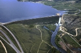
Clark Canyon Dam is an earthfill dam
located in Beaverhead County, Montana
, about 20 miles (30 km) south of the county seat of Dillon
. The dam impounds the waters of the Beaverhead River
, creating a body of water known as Clark Canyon Reservoir. The structure was constructed in 1961-1964 by the United States Bureau of Reclamation
, to hold water for downstream irrigation and for flood-control purposes.
Clark Canyon Dam has a crest length of 2,950 feet (899 m), and a maximum height of 147 feet (45 m). The dam contains 1,970,000 cubic yards (1,510,000 m³) of material. The elevation of the dam crest is 5,578 feet (1,700 m). The reservoir has a total capacity of 257152 acre.ft, and when full has a surface area of 5,903 acres (24 km²).
Construction of the dam and reservoir required the relocation of U.S. Route 91
(rebuilt as Interstate 15) and a main line of the Union Pacific Railroad
. The reservoir inundated the former site of the small community of Armstead, Montana
, and the site of Camp Fortunate, where the Lewis and Clark Expedition
camped from August 17 to 22, 1805 and held negotiations with the Shoshone
.
Dam
A dam is a barrier that impounds water or underground streams. Dams generally serve the primary purpose of retaining water, while other structures such as floodgates or levees are used to manage or prevent water flow into specific land regions. Hydropower and pumped-storage hydroelectricity are...
located in Beaverhead County, Montana
Beaverhead County, Montana
-National protected areas:* Beaverhead National Forest * Big Hole National Battlefield* Nez Perce National Historical Park * Red Rock Lakes National Wildlife Refuge-History:...
, about 20 miles (30 km) south of the county seat of Dillon
Dillon, Montana
- Notable residents :* Ed Barker - NFL wide receiver - Washington Redskins* Cree Paul - [Where is she now?]* Charles Xavier Larrabee - owner of the nearby stock ranch Brooknook.* Lloyd Meeds - Politician, lobbyist, and navy officer....
. The dam impounds the waters of the Beaverhead River
Beaverhead River
The Beaverhead River is an approximately -long tributary of the Jefferson River in southwest Montana . It drains an area of roughly . The river's original headwaters, formed by the confluence of the Red Rock River and Horse Prairie Creek, are now flooded under Clark Canyon Reservoir, which also...
, creating a body of water known as Clark Canyon Reservoir. The structure was constructed in 1961-1964 by the United States Bureau of Reclamation
United States Bureau of Reclamation
The United States Bureau of Reclamation , and formerly the United States Reclamation Service , is an agency under the U.S...
, to hold water for downstream irrigation and for flood-control purposes.
Clark Canyon Dam has a crest length of 2,950 feet (899 m), and a maximum height of 147 feet (45 m). The dam contains 1,970,000 cubic yards (1,510,000 m³) of material. The elevation of the dam crest is 5,578 feet (1,700 m). The reservoir has a total capacity of 257152 acre.ft, and when full has a surface area of 5,903 acres (24 km²).
Construction of the dam and reservoir required the relocation of U.S. Route 91
U.S. Route 91
U.S. Route 91 is a north–south United States highway. The highway currently serves as a connection between the Cache Valley area of Utah and Idaho to the Salt Lake and Idaho Falls population centers. Prior the mid-1970s, U.S. 91 was an international commerce route from Long Beach, California...
(rebuilt as Interstate 15) and a main line of the Union Pacific Railroad
Union Pacific Railroad
The Union Pacific Railroad , headquartered in Omaha, Nebraska, is the largest railroad network in the United States. James R. Young is president, CEO and Chairman....
. The reservoir inundated the former site of the small community of Armstead, Montana
Armstead, Montana
Armstead is a ghost town in Beaverhead County, Montana, United States, about south of the county seat of Dillon. It was named after miner Harry Armstead. Armstead was located in a narrow valley of the Beaverhead River, near the mouth of Horse Prairie Creek. The town was a station stop on the...
, and the site of Camp Fortunate, where the Lewis and Clark Expedition
Lewis and Clark Expedition
The Lewis and Clark Expedition, or ″Corps of Discovery Expedition" was the first transcontinental expedition to the Pacific Coast by the United States. Commissioned by President Thomas Jefferson and led by two Virginia-born veterans of Indian wars in the Ohio Valley, Meriwether Lewis and William...
camped from August 17 to 22, 1805 and held negotiations with the Shoshone
Shoshone
The Shoshone or Shoshoni are a Native American tribe in the United States with three large divisions: the Northern, the Western and the Eastern....
.