
.gif)
Clarence River (New South Wales)
Encyclopedia
New South Wales
New South Wales is a state of :Australia, located in the east of the country. It is bordered by Queensland, Victoria and South Australia to the north, south and west respectively. To the east, the state is bordered by the Tasman Sea, which forms part of the Pacific Ocean. New South Wales...
, Australia
Australia
Australia , officially the Commonwealth of Australia, is a country in the Southern Hemisphere comprising the mainland of the Australian continent, the island of Tasmania, and numerous smaller islands in the Indian and Pacific Oceans. It is the world's sixth-largest country by total area...
. The river originates on the watershed that marks the Queensland
Queensland
Queensland is a state of Australia, occupying the north-eastern section of the mainland continent. It is bordered by the Northern Territory, South Australia and New South Wales to the west, south-west and south respectively. To the east, Queensland is bordered by the Coral Sea and Pacific Ocean...
border. After flowing south and northeast for 394 km it then empties into the Pacific Ocean
Pacific Ocean
The Pacific Ocean is the largest of the Earth's oceanic divisions. It extends from the Arctic in the north to the Southern Ocean in the south, bounded by Asia and Australia in the west, and the Americas in the east.At 165.2 million square kilometres in area, this largest division of the World...
at Iluka
Iluka, New South Wales
Iluka is a small village at the mouth of the Clarence River in New South Wales, Australia. It is situated directly across the river from the resort town of Yamba. At the 2006 census, Iluka had a population of 1,739 people. The town's name is derived from an aboriginal word meaning 'near the sea'.It...
/Yamba
Yamba, New South Wales
Yamba is a town in northern New South Wales, Australia at the mouth of the Clarence River. The first European to visit the area was Matthew Flinders, who stopped by in Yamba Bay for six days in July 1799....
. On its journey it passes through the towns of Grafton
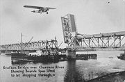
Grafton, New South Wales
The city of Grafton is the commercial hub of the Clarence River Valley. Established in 1851, Grafton features many historic buildings and tree-lined streets. Located approximately 630 kilometres north of Sydney and 340 km south of Brisbane, Grafton and the Clarence Valley can be reached...
, Ulmarra
Ulmarra, New South Wales
Ulmarra is a small town on the south bank of the Clarence River in New South Wales, Australia. It is located in the Clarence Valley district. At the 2006 census, Ulmarra had a population of 446 people....
, Cowper/Brushgrove, Maclean
Maclean, New South Wales
Maclean is a town in Clarence Valley Local Government Area in the Northern Rivers region of New South Wales, Australia. It is on the Clarence River and near the Pacific Highway. At the 2006 census, Maclean had a population of 3,245 people...
and Harwood. Its chief tributaries are the Mann River, Nymboida River
Nymboida River
The Nymboida River is a river in the Northern Rivers region of New South Wales in Australia. The headwaters of the river rise approximately 30 kilometres to the west of Dorrigo in the New England National Park near Barren Mountain....
, and Orara River
Orara River
The Orara River is a significant tributary of the Clarence River, located in northern New South Wales, Australia.The river begins in the hills behind the city of Coffs Harbour and runs in a general north-westerly direction for approximately 100 kilometres to the Clarence River at Eatonsville,...
. The river features many large river islands, including Woodford Island
Woodford Island
Woodford Island is an inland island in the Far-North Coast of New South Wales, Australia. It is formed by the Clarence River where it splits into the South Arm and North Arm at the small village of Brushgrove then reforms at the town of Maclean...
, Chatsworth Island, and Harwood Island. The river supports a large prawn trawling and fishing industry.
The Clarence River system is an extensive East Coast drainage with many tributaries of differing size. Apart from the Murray River
Murray River
The Murray River is Australia's longest river. At in length, the Murray rises in the Australian Alps, draining the western side of Australia's highest mountains and, for most of its length, meanders across Australia's inland plains, forming the border between New South Wales and Victoria as it...
, it is the largest river in mainland Australia south of the Tropic of Capricorn
Tropic of Capricorn
The Tropic of Capricorn, or Southern tropic, marks the most southerly latitude on the Earth at which the Sun can be directly overhead. This event occurs at the December solstice, when the southern hemisphere is tilted towards the Sun to its maximum extent.Tropic of Capricorn is one of the five...
, though its flow for comparison is only half that of the Potomac
Potomac River
The Potomac River flows into the Chesapeake Bay, located along the mid-Atlantic coast of the United States. The river is approximately long, with a drainage area of about 14,700 square miles...
. Its basin is, together with the very similarly-sized Hawkesbury
Hawkesbury River
The Hawkesbury River, also known as Deerubbun, is one of the major rivers of the coastal region of New South Wales, Australia. The Hawkesbury River and its tributaries virtually encircle the metropolitan region of Sydney.-Geography:-Course:...
, Australia's largest Pacific watershed south of Bundaberg. The extremely intense rainfalls that typify the North Coast mean, however, that major floods can temporarily raise the flow of the Clarence to levels equivalent to some of the largest rivers in the world.
The climate of most of the basin is subtropical (Köppen
Köppen climate classification
The Köppen climate classification is one of the most widely used climate classification systems. It was first published by Crimea German climatologist Wladimir Köppen in 1884, with several later modifications by Köppen himself, notably in 1918 and 1936...
Cfa), though the highest areas with cooler weather are of the temperate Cfb type. Annual rainfall ranges from 1600 millimetres (63 in) on the coast at Yamba down to 960 millimetres (37.8 in) in the shielded valley at Grafton. At higher altitudes, rainfall may reach 2000 millimetres (78.7 in) on exposed slopes but data are very poor. Most of the high areas actually receive no more rain than Grafton though variability from year to year is less. Temperatures are generally very warm, with maxima in lower area ranging from 27 °C (80.6 °F) in January to 19 °C (66.2 °F) in July. In the highlands, however, temperatures are much cooler and in July range from lows of around 2 °C (35.6 °F) to maxima around 13 °C (55.4 °F) - though in January days remain very warm at around 25 °C (77 °F). Rainfall per month on the coast typically ranges from around 220 millimetres (8.7 in) in February and March to around 70 millimetres (2.8 in) in September; it can average as low as 40 millimetres (1.6 in) between May and September inland, where exposed areas sometimes suffer bushfires after drought
Drought
A drought is an extended period of months or years when a region notes a deficiency in its water supply. Generally, this occurs when a region receives consistently below average precipitation. It can have a substantial impact on the ecosystem and agriculture of the affected region...
s, as occurred in 1915 and 2000.
Most of the Clarence basin is heavily forested, with important areas of remnant subtropical and temperate rainforest occurring all along the course. Only in alluvial areas where soil
Soil
Soil is a natural body consisting of layers of mineral constituents of variable thicknesses, which differ from the parent materials in their morphological, physical, chemical, and mineralogical characteristics...
s are less leached is there major agricultural development: in these areas the chief industries are cattle
Cattle
Cattle are the most common type of large domesticated ungulates. They are a prominent modern member of the subfamily Bovinae, are the most widespread species of the genus Bos, and are most commonly classified collectively as Bos primigenius...
rearing and the growing of sugar cane in lower-lying areas.
Of particular interest is the small island town of Harwood, where a Sperry New Holland factory and a quaint Bush Pub overlook the Clarence Delta. Harwood is also the location of the local sugar Mill, the Harwood Sugar Mill
Harwood Mill
The Harwood Sugar Mill is located on Harwood Island on the Clarence River in the Northern Rivers region in north-eastern New South Wales, Australia. It began operations in 1874, and is the oldest mill still operating in Australia...
built in 1873 and is the oldest Australian mill still operational. The sugar mill is situated on the river due to its importance in transporting sugar cane from farms in the surrounding area in previous times. Harwood is just after the Yamba Bridge on part of Australia
Australia
Australia , officially the Commonwealth of Australia, is a country in the Southern Hemisphere comprising the mainland of the Australian continent, the island of Tasmania, and numerous smaller islands in the Indian and Pacific Oceans. It is the world's sixth-largest country by total area...
's National Highway
National Highway (Australia)
thumb|right|150px|The National Highway Shield in NSW, QLD, WA, NT & TAS.The National Highway is a system of roads connecting all the States and Territories of Australia, and is the major network of highways connecting Australia's largest and most important cities.The National Highway was...
from Sydney
Sydney
Sydney is the most populous city in Australia and the state capital of New South Wales. Sydney is located on Australia's south-east coast of the Tasman Sea. As of June 2010, the greater metropolitan area had an approximate population of 4.6 million people...
, Port Macquarie, Coffs Harbour to Brisbane
Brisbane
Brisbane is the capital and most populous city in the Australian state of Queensland and the third most populous city in Australia. Brisbane's metropolitan area has a population of over 2 million, and the South East Queensland urban conurbation, centred around Brisbane, encompasses a population of...
.
The freshwater reaches of the Clarence River support important populations of native freshwater fish including Eastern freshwater cod
Eastern freshwater cod
Eastern freshwater cod, Maccullochella ikei, also known as eastern cod, are a large and striking predatory freshwater fish of the Maccullochella genus and the Percichthyidae family, that occur in the coastal Clarence River system of north-eastern New South Wales...
, an endangered fish species unique to the Clarence River system, and Australian bass
Australian bass
Australian bass are a small to medium sized, primarily freshwater native fish found in coastal rivers and streams along the east coast of Australia. They are a member of the Percichthyidae family and, currently, the Macquaria genus. Australian bass are an iconic, highly predatory native fish...
.
The lower half of the river valley is part of the Local Government Area of the Clarence Valley.
The Aboriginal people of the lower reaches call the river there Breimba or Berrinbah.