

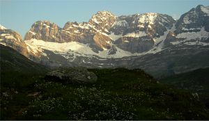
Cirque d'Estaubé
Encyclopedia
Cirque (landform)
thumb|250 px|Two cirques with semi-permanent snowpatches in [[Abisko National Park]], [[Sweden]].A cirque or corrie is an amphitheatre-like valley head, formed at the head of a valley glacier by erosion...
in the central Pyrenees
Pyrenees
The Pyrenees is a range of mountains in southwest Europe that forms a natural border between France and Spain...
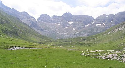
in the Pyrenees National Park
Pyrenees National Park
The Pyrénées National Park is a national park located within the French départements of Hautes-Pyrénées and Pyrénées-Atlantiques.Located along the border of France and Spain is a scenic and mountainous landscape offering a variety of outdoor activities including hiking, skiing, mountain climbing...
, forming the frontier between France
France
The French Republic , The French Republic , The French Republic , (commonly known as France , is a unitary semi-presidential republic in Western Europe with several overseas territories and islands located on other continents and in the Indian, Pacific, and Atlantic oceans. Metropolitan France...
and Spain
Spain
Spain , officially the Kingdom of Spain languages]] under the European Charter for Regional or Minority Languages. In each of these, Spain's official name is as follows:;;;;;;), is a country and member state of the European Union located in southwestern Europe on the Iberian Peninsula...
. The cirque lies 4 km to the east of its better known neighbour, the Cirque de Gavarnie
Cirque de Gavarnie
The Cirque de Gavarnie is a cirque in the central Pyrenees, in the Pyrenees National Park. The cirque is 800m wide and about 3000m wide at the top.Major features of the cirque are La Brèche de Roland and the Gavarnie Falls....
, which is accessible via the Hourquette d'Alans (2,430 m); the Marboré valley is reached via the Brèche de Tuquerouye (Tuca Arroja) (2,666 m), where there is a small CAF hut.
The Gave d'Estaubé descends north from the cirque, first flowing into a small reservoir, the Barrage des Gloriettes (1,668 m), then into the main Héas valley.
Principal summits
- Pic Rouge de Pailla (2,780 m/2,779 m)
- Grand Astazou (3,071 m /3,083 m)
- Pic de Tuquerouye (Pic de Tuquerouge) (2,819 m)
- Pic de Pinède (2,860 m/2,861 m)
- Pic Blanc (2,828 m)
- Pic de la Canau (2,766 m)
- Soum de Port Bieil (2,846 m)
- Pics d'Estaubé (2,810 m)