

Cimmerian Plate
Encyclopedia
Anatolia
Anatolia is a geographic and historical term denoting the westernmost protrusion of Asia, comprising the majority of the Republic of Turkey...
, Iran
Iran
Iran , officially the Islamic Republic of Iran , is a country in Southern and Western Asia. The name "Iran" has been in use natively since the Sassanian era and came into use internationally in 1935, before which the country was known to the Western world as Persia...
, Afghanistan
Afghanistan
Afghanistan , officially the Islamic Republic of Afghanistan, is a landlocked country located in the centre of Asia, forming South Asia, Central Asia and the Middle East. With a population of about 29 million, it has an area of , making it the 42nd most populous and 41st largest nation in the world...
, Tibet
Tibet
Tibet is a plateau region in Asia, north-east of the Himalayas. It is the traditional homeland of the Tibetan people as well as some other ethnic groups such as Monpas, Qiang, and Lhobas, and is now also inhabited by considerable numbers of Han and Hui people...
, Indochina
Indochina
The Indochinese peninsula, is a region in Southeast Asia. It lies roughly southwest of China, and east of India. The name has its origins in the French, Indochine, as a combination of the names of "China" and "India", and was adopted when French colonizers in Vietnam began expanding their territory...
and Malaya
Malay Peninsula
The Malay Peninsula or Thai-Malay Peninsula is a peninsula in Southeast Asia. The land mass runs approximately north-south and, at its terminus, is the southern-most point of the Asian mainland...
regions. The Cimmerian Plate was formerly part of the ancient supercontinent
Supercontinent
In geology, a supercontinent is a landmass comprising more than one continental core, or craton. The assembly of cratons and accreted terranes that form Eurasia qualifies as a supercontinent today.-History:...
of Pangaea
Pangaea
Pangaea, Pangæa, or Pangea is hypothesized as a supercontinent that existed during the Paleozoic and Mesozoic eras about 250 million years ago, before the component continents were separated into their current configuration....
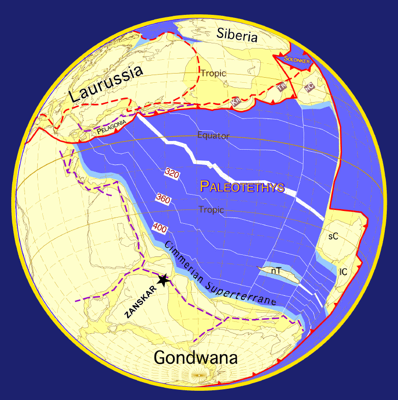
. Pangaea was shaped like a vast "C", facing east, and inside of the "C" was the Paleo-Tethys Ocean
Paleo-Tethys Ocean
The Paleo-Tethys Ocean was an ancient Paleozoic ocean. It was located between the paleocontinent Gondwana and the so called Hunic terranes. These are divided into the European Hunic and Asiatic Hunic...
. Two microcontinents, which are part of present-day China
China
Chinese civilization may refer to:* China for more general discussion of the country.* Chinese culture* Greater China, the transnational community of ethnic Chinese.* History of China* Sinosphere, the area historically affected by Chinese culture...
, lay in the eastern expanse of the Paleo-Tethys Ocean
Paleo-Tethys Ocean
The Paleo-Tethys Ocean was an ancient Paleozoic ocean. It was located between the paleocontinent Gondwana and the so called Hunic terranes. These are divided into the European Hunic and Asiatic Hunic...
. About 300 Mya (million years ago), a rift
Rift
In geology, a rift or chasm is a place where the Earth's crust and lithosphere are being pulled apart and is an example of extensional tectonics....
started opening from the east which split a long, thin arc off of the inside of the southern arm of the continent, which comprised present day Australia
Australia
Australia , officially the Commonwealth of Australia, is a country in the Southern Hemisphere comprising the mainland of the Australian continent, the island of Tasmania, and numerous smaller islands in the Indian and Pacific Oceans. It is the world's sixth-largest country by total area...
, Antarctica, India
India
India , officially the Republic of India , is a country in South Asia. It is the seventh-largest country by geographical area, the second-most populous country with over 1.2 billion people, and the most populous democracy in the world...
, and Africa
Africa
Africa is the world's second largest and second most populous continent, after Asia. At about 30.2 million km² including adjacent islands, it covers 6% of the Earth's total surface area and 20.4% of the total land area...
-Arabia. This micro-continent has been named Cimmeria
Cimmeria (continent)
Cimmeria was an ancient microcontinent that existed about 200 million years ago. It rifted north from Gondwana during the Late Carboniferous and collided against eastern Laurasia during the Late Triassic together with the Chinese continents. The collision created new mountain ranges between...
. Behind this new micro-continent the rift formed a new ocean, the Tethys Ocean
Tethys Ocean
The Tethys Ocean was an ocean that existed between the continents of Gondwana and Laurasia during the Mesozoic era before the opening of the Indian Ocean.-Modern theory:...
. As the Tethys Ocean widened, it pushed Cimmeria and the floor of the Paleo-Tethys Ocean
Paleo-Tethys Ocean
The Paleo-Tethys Ocean was an ancient Paleozoic ocean. It was located between the paleocontinent Gondwana and the so called Hunic terranes. These are divided into the European Hunic and Asiatic Hunic...
northward towards Laurasia
Laurasia
In paleogeography, Laurasia was the northernmost of two supercontinents that formed part of the Pangaea supercontinent from approximately...
, the northeastern arm of Pangaea.
Subduction
In geology, subduction is the process that takes place at convergent boundaries by which one tectonic plate moves under another tectonic plate, sinking into the Earth's mantle, as the plates converge. These 3D regions of mantle downwellings are known as "Subduction Zones"...
under Laurasia and Cimmeria
Cimmeria (continent)
Cimmeria was an ancient microcontinent that existed about 200 million years ago. It rifted north from Gondwana during the Late Carboniferous and collided against eastern Laurasia during the Late Triassic together with the Chinese continents. The collision created new mountain ranges between...
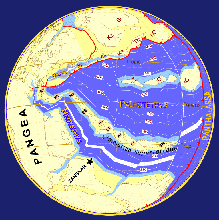
eventually collided with Laurasia, first at its western end c. 220 Ma, and Paleo-Tethys began to disappear altogether, closing from west to east. The collision of the continents raised mountains along the suture, called the Cimmerian orogeny
Cimmerian Orogeny
The Cimmerian Orogeny, is an orogeny that created mountain ranges that now lie in Central Asia. The orogeny is believed to have begun 200 - 150 million years ago , when the Cimmerian plate collided with the southern coast of Kazakhstania and North and South China, closing the ancient Paleo-Tethys...
. On its eastern end, Cimmeria collided with the Chinese micro-continents c. 200 Ma, and the Cimmerian orogeny was extended along the entire northern boundary of the plate. Most of Paleo-Tethys disappeared by c.150 Ma. More mountains were raised as the northern edge of the China plates collided with eastern Laurasia. After it collided with Laurasia around 200 Ma (Early Jurassic
Early Jurassic
The Early Jurassic epoch is the earliest of three epochs of the Jurassic period...
), the Tethyan Trench
Tethyan Trench
The Tethyan Trench was an ancient oceanic trench that existed in the northern part of the Tethys Ocean during the middle Mesozoic to early Cenozoic eras.-Geology:...
formed on southern Cimmeria, subducting the Tethys Ocean
Tethys Ocean
The Tethys Ocean was an ocean that existed between the continents of Gondwana and Laurasia during the Mesozoic era before the opening of the Indian Ocean.-Modern theory:...
which created island arc
Island arc
An island arc is a type of archipelago composed of a chain of volcanoes which alignment is arc-shaped, and which are situated parallel and close to a boundary between two converging tectonic plates....
s and new mountain range
Mountain range
A mountain range is a single, large mass consisting of a succession of mountains or narrowly spaced mountain ridges, with or without peaks, closely related in position, direction, formation, and age; a component part of a mountain system or of a mountain chain...
s in the area.
The Tethys rift eventually extended westward to split Pangaea in two, and the growing Atlantic Ocean
Atlantic Ocean
The Atlantic Ocean is the second-largest of the world's oceanic divisions. With a total area of about , it covers approximately 20% of the Earth's surface and about 26% of its water surface area...
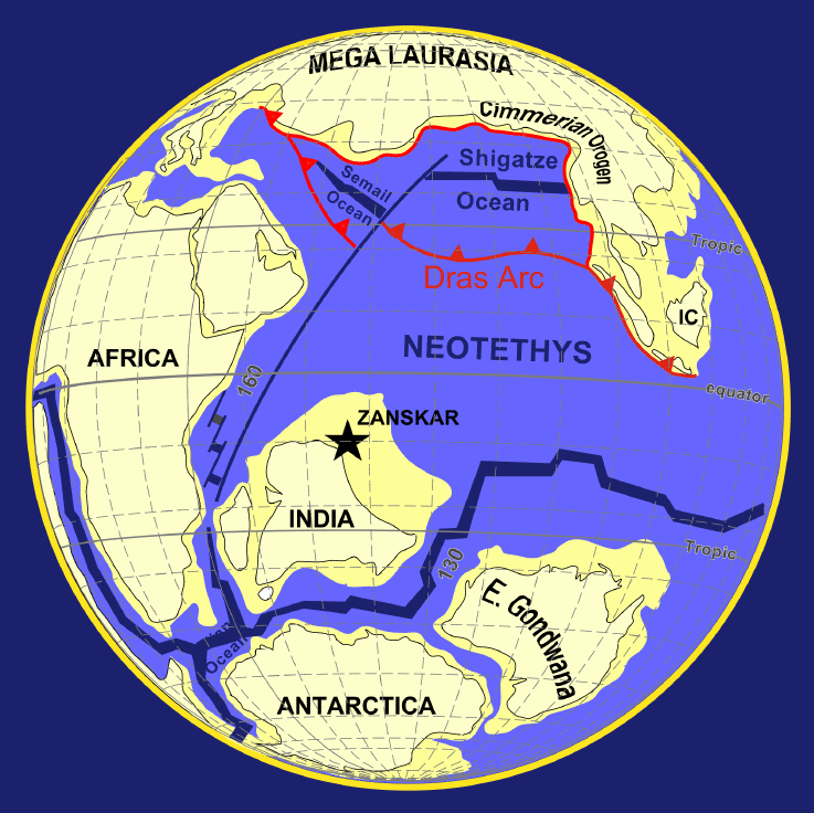
separated the northern supercontinent of Laurasia from the southern supercontinent Gondwana. Around 150 Ma Gondwana also began to rift apart c. 150 Ma, and the continents of India and Africa-Arabia began to drift north towards Laurasia, of which Cimmeria
Cimmeria (continent)
Cimmeria was an ancient microcontinent that existed about 200 million years ago. It rifted north from Gondwana during the Late Carboniferous and collided against eastern Laurasia during the Late Triassic together with the Chinese continents. The collision created new mountain ranges between...
now formed the southern coast. Africa-Arabia and India eventually collided with Asia c. 30 Ma, reuniting Cimmeria with its former Gondwanian neighbors and buckling and folding the former Cimmerian continent to form the Alps
Alps
The Alps is one of the great mountain range systems of Europe, stretching from Austria and Slovenia in the east through Italy, Switzerland, Liechtenstein and Germany to France in the west....
, Caucasus
Caucasus
The Caucasus, also Caucas or Caucasia , is a geopolitical region at the border of Europe and Asia, and situated between the Black and the Caspian sea...
, Zagros Mountains
Zagros Mountains
The Zagros Mountains are the largest mountain range in Iran and Iraq. With a total length of 1,500 km , from northwestern Iran, and roughly correlating with Iran's western border, the Zagros range spans the whole length of the western and southwestern Iranian plateau and ends at the Strait of...
, Hindu Kush
Hindu Kush
The Hindu Kush is an mountain range that stretches between central Afghanistan and northern Pakistan. The highest point in the Hindu Kush is Tirich Mir in the Chitral region of Khyber-Pakhtunkhwa, Pakistan.It is the westernmost extension of the Pamir Mountains, the Karakoram Range, and is a...
, the Pamir Mountains
Pamir Mountains
The Pamir Mountains are a mountain range in Central Asia formed by the junction or knot of the Himalayas, Tian Shan, Karakoram, Kunlun, and Hindu Kush ranges. They are among the world’s highest mountains and since Victorian times they have been known as the "Roof of the World" a probable...
, the Sulaiman Mountains, the Iranian plateau
Iranian plateau
The Iranian plateau, or Iranic plateau, is a geological formation in Southwest Asia. It is the part of the Eurasian Plate wedged between the Arabian and Indian plates, situated between the Zagros mountains to the west, the Caspian Sea and the Kopet Dag to the north, the Hormuz Strait and Persian...
, the Himalayas, the Tibetan Plateau
Tibetan Plateau
The Tibetan Plateau , also known as the Qinghai–Tibetan Plateau is a vast, elevated plateau in Central Asia covering most of the Tibet Autonomous Region and Qinghai, in addition to smaller portions of western Sichuan, southwestern Gansu, and northern Yunnan in Western China and Ladakh in...
, and the Burmese highlands. This is called the Alpine orogeny
Alpine orogeny
The Alpine orogeny is an orogenic phase in the Late Mesozoic and Tertiary that formed the mountain ranges of the Alpide belt...
).
See also
- Geology of the HimalayaGeology of the HimalayaThe geology of the Himalaya is a record of the most dramatic and visible creations of modern plate tectonic forces. The Himalayas, which stretch over 2400 km between the Namche Barwa syntaxis in Tibet and the Nanga Parbat syntaxis in Pakistan, are the result of an ongoing orogeny — the result...
- Tethys OceanTethys OceanThe Tethys Ocean was an ocean that existed between the continents of Gondwana and Laurasia during the Mesozoic era before the opening of the Indian Ocean.-Modern theory:...
- Paleo-Tethys OceanPaleo-Tethys OceanThe Paleo-Tethys Ocean was an ancient Paleozoic ocean. It was located between the paleocontinent Gondwana and the so called Hunic terranes. These are divided into the European Hunic and Asiatic Hunic...
- PangaeaPangaeaPangaea, Pangæa, or Pangea is hypothesized as a supercontinent that existed during the Paleozoic and Mesozoic eras about 250 million years ago, before the component continents were separated into their current configuration....
- Pangaea UltimaPangaea UltimaPangaea Ultima is a possible future supercontinent configuration and an alternative to the Amasia supercontinent. Consistent with the supercontinent cycle, Pangaea Ultima could occur within the next 250 million years...
- Supercontinent cycleSupercontinent cycleThe supercontinent cycle describes the quasi-periodic aggregation and dispersal of Earth's continental crust. There are varying opinions as to whether the amount of continental crust is increasing, decreasing, or staying about the same, but it is agreed that the Earth's crust is constantly being...
External links
- Website of the PALEOMAP Project
- Late Permian paleoglobe showing the expanding Tethys Ocean, the closure of Paleo-Tethys, and the movement of the Cimmerian Plate
- Early Jurassic paleoglobe showing the a narrow seaway of Paleo-Tethys Ocean, and beginnings of the Cimmerian OrogenyCimmerian OrogenyThe Cimmerian Orogeny, is an orogeny that created mountain ranges that now lie in Central Asia. The orogeny is believed to have begun 200 - 150 million years ago , when the Cimmerian plate collided with the southern coast of Kazakhstania and North and South China, closing the ancient Paleo-Tethys...