
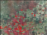
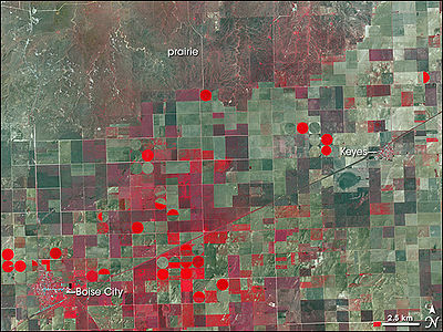
Cimarron County, Oklahoma
Encyclopedia
U.S. state
A U.S. state is any one of the 50 federated states of the United States of America that share sovereignty with the federal government. Because of this shared sovereignty, an American is a citizen both of the federal entity and of his or her state of domicile. Four states use the official title of...
of Oklahoma
Oklahoma
Oklahoma is a state located in the South Central region of the United States of America. With an estimated 3,751,351 residents as of the 2010 census and a land area of 68,667 square miles , Oklahoma is the 28th most populous and 20th-largest state...
. Throughout most of its history it has had the smallest population and the lowest population density of any county in Oklahoma. As of 2010 census, the population was 2,475. Its county seat
County seat
A county seat is an administrative center, or seat of government, for a county or civil parish. The term is primarily used in the United States....
is Boise City
Boise City, Oklahoma
Boise City is a city in and the county seat of Cimarron County, Oklahoma, United States. The population was 1,266 at the 2010 census.'Boise' rhymes with 'voice'...
.
Geography
Cimarron County is the only county in the United States that borders four states: ColoradoColorado
Colorado is a U.S. state that encompasses much of the Rocky Mountains as well as the northeastern portion of the Colorado Plateau and the western edge of the Great Plains...
, Kansas
Kansas
Kansas is a US state located in the Midwestern United States. It is named after the Kansas River which flows through it, which in turn was named after the Kansa Native American tribe, which inhabited the area. The tribe's name is often said to mean "people of the wind" or "people of the south...
, New Mexico
New Mexico
New Mexico is a state located in the southwest and western regions of the United States. New Mexico is also usually considered one of the Mountain States. With a population density of 16 per square mile, New Mexico is the sixth-most sparsely inhabited U.S...
, and Texas
Texas
Texas is the second largest U.S. state by both area and population, and the largest state by area in the contiguous United States.The name, based on the Caddo word "Tejas" meaning "friends" or "allies", was applied by the Spanish to the Caddo themselves and to the region of their settlement in...
. As a result, Cimarron County is the only county in the United States to border at least five counties from five different states (one from each of the four aforementioned states, plus one in Oklahoma and a second county in Texas). According to the United States Census Bureau
United States Census Bureau
The United States Census Bureau is the government agency that is responsible for the United States Census. It also gathers other national demographic and economic data...
, the county has a total area of 1841 square miles (4,768 km²), of which 1835 square miles (4,753 km²) is land and 6 square miles (16 km²) (0.33%) is water. It also has Oklahoma's highest point at 4973 feet (1,516 m) (AMSL
Above mean sea level
The term above mean sea level refers to the elevation or altitude of any object, relative to the average sea level datum. AMSL is used extensively in radio by engineers to determine the coverage area a station will be able to reach...
) on the Black Mesa.
A location 300 yards east of Rt. 287/385 1.75 miles south of the Cimarron River is the only place in the US
United States
The United States of America is a federal constitutional republic comprising fifty states and a federal district...
less than 27 miles from five different states: 26.99 miles from Kansas
Kansas
Kansas is a US state located in the Midwestern United States. It is named after the Kansas River which flows through it, which in turn was named after the Kansa Native American tribe, which inhabited the area. The tribe's name is often said to mean "people of the wind" or "people of the south...
, New Mexico
New Mexico
New Mexico is a state located in the southwest and western regions of the United States. New Mexico is also usually considered one of the Mountain States. With a population density of 16 per square mile, New Mexico is the sixth-most sparsely inhabited U.S...
, and Texas
Texas
Texas is the second largest U.S. state by both area and population, and the largest state by area in the contiguous United States.The name, based on the Caddo word "Tejas" meaning "friends" or "allies", was applied by the Spanish to the Caddo themselves and to the region of their settlement in...
and seven miles from Colorado
Colorado
Colorado is a U.S. state that encompasses much of the Rocky Mountains as well as the northeastern portion of the Colorado Plateau and the western edge of the Great Plains...
.
Major highways

 U.S. Highway 56/U.S. Highway 412
 U.S. Highway 64
 U.S. Highway 287
 U.S. Highway 385
 State Highway 3State Highway 3 (Oklahoma)State Highway 3, also abbreviated as SH-3 or OK-3, is a highway maintained by the U.S. state of Oklahoma. Traveling diagonally through Oklahoma, from the Panhandle to the far southeastern corner of the state, SH-3 is the longest state highway in the Oklahoma road system, at a total length of...
Adjacent counties
- Baca County, ColoradoBaca County, ColoradoBaca County is the southeasternmost of the 64 counties of the state of Colorado of the United States. The county population was 4,517 at U.S. Census 2000. The county seat is Springfield.- History :...
(north) - Morton County, KansasMorton County, KansasMorton County is a county located in the U.S. state of Kansas. As of the 2010 census, the county population was 3,233...
(northeast) - Texas County, OklahomaTexas County, OklahomaTexas County is a county located in the U.S. state of Oklahoma. Texas County was formed at Oklahoma statehood from the central one-third of "Old Beaver County" also known as "No Man's Land"...
(east) - Dallam County, Texas (south)
- Sherman County, Texas (southeast)
- Union County, New MexicoUnion County, New Mexico-2010:Whereas according to the 2010 U.S. Census Bureau:*81.7% White*1.8% Black*2.0% Native American*0.5% Asian*0.0% Native Hawaiian or Pacific Islander*2.3% Two or more races*11.7% Other races*39.7% Hispanic or Latino -2000:...
(west)
National protected area
- Rita Blanca National GrasslandRita Blanca National GrasslandRita Blanca National Grassland is a National Grassland located in northern Dallam County, Texas, in the Texas Panhandle, and in southern Cimarron County, Oklahoma, in the western Oklahoma Panhandle, USA. It is not one solid block of government owned land but rather several small blocks of...
(part)

Demographics

Census
A census is the procedure of systematically acquiring and recording information about the members of a given population. It is a regularly occurring and official count of a particular population. The term is used mostly in connection with national population and housing censuses; other common...
of 2000, there were 3,148 people, 1,257 households, and 868 families residing in the county. The population density
Population density
Population density is a measurement of population per unit area or unit volume. It is frequently applied to living organisms, and particularly to humans...
was 2 people per square mile (1/km²). There were 1,583 housing units at an average density of 1 per square mile (0/km²). The racial makeup of the county was 85.77% White
Race (United States Census)
Race and ethnicity in the United States Census, as defined by the Federal Office of Management and Budget and the United States Census Bureau, are self-identification data items in which residents choose the race or races with which they most closely identify, and indicate whether or not they are...
, 0.57% Black
Race (United States Census)
Race and ethnicity in the United States Census, as defined by the Federal Office of Management and Budget and the United States Census Bureau, are self-identification data items in which residents choose the race or races with which they most closely identify, and indicate whether or not they are...
or African American
Race (United States Census)
Race and ethnicity in the United States Census, as defined by the Federal Office of Management and Budget and the United States Census Bureau, are self-identification data items in which residents choose the race or races with which they most closely identify, and indicate whether or not they are...
, 1.02% Native American
Race (United States Census)
Race and ethnicity in the United States Census, as defined by the Federal Office of Management and Budget and the United States Census Bureau, are self-identification data items in which residents choose the race or races with which they most closely identify, and indicate whether or not they are...
, 0.16% Asian
Race (United States Census)
Race and ethnicity in the United States Census, as defined by the Federal Office of Management and Budget and the United States Census Bureau, are self-identification data items in which residents choose the race or races with which they most closely identify, and indicate whether or not they are...
, 9.94% from other races
Race (United States Census)
Race and ethnicity in the United States Census, as defined by the Federal Office of Management and Budget and the United States Census Bureau, are self-identification data items in which residents choose the race or races with which they most closely identify, and indicate whether or not they are...
, and 2.54% from two or more races. 15.41% of the population were Hispanic
Race (United States Census)
Race and ethnicity in the United States Census, as defined by the Federal Office of Management and Budget and the United States Census Bureau, are self-identification data items in which residents choose the race or races with which they most closely identify, and indicate whether or not they are...
or Latino
Race (United States Census)
Race and ethnicity in the United States Census, as defined by the Federal Office of Management and Budget and the United States Census Bureau, are self-identification data items in which residents choose the race or races with which they most closely identify, and indicate whether or not they are...
of any race.
There were 1,257 households out of which 31.30% had children under the age of 18 living with them, 60.40% were married couples
Marriage
Marriage is a social union or legal contract between people that creates kinship. It is an institution in which interpersonal relationships, usually intimate and sexual, are acknowledged in a variety of ways, depending on the culture or subculture in which it is found...
living together, 6.00% had a female householder with no husband present, and 30.90% were non-families. 29.30% of all households were made up of individuals and 15.50% had someone living alone who was 65 years of age or older. The average household size was 2.47 and the average family size was 3.07.
In the county, the population was spread out with 27.60% under the age of 18, 6.40% from 18 to 24, 23.40% from 25 to 44, 24.00% from 45 to 64, and 18.60% who were 65 years of age or older. The median age was 39 years. For every 100 females there were 97.40 males. For every 100 females age 18 and over, there were 95.30 males.
The median income for a household in the county was $30,625, and the median income for a family was $36,250. Males had a median income of $24,327 versus $18,110 for females. The per capita income
Per capita income
Per capita income or income per person is a measure of mean income within an economic aggregate, such as a country or city. It is calculated by taking a measure of all sources of income in the aggregate and dividing it by the total population...
for the county was $15,744. About 13.90% of families and 17.60% of the population were below the poverty line, including 22.20% of those under age 18 and 10.10% of those age 65 or over.