

Chihuahua
Encyclopedia
Chihuahua officially Estado Libre y Soberano de Chihuahua (Free and Sovereign State of Chihuahua) is one of the 31 states which, with the Federal District
, comprise the 32 Federal Entities of Mexico
. Its capital city is Chihuahua
.
It is located in Northwestern Mexico. It is bordered by the states of Sonora
to the west, Sinaloa
to the southwest, Durango
to the south, and Coahuila
to the east. To the north and northeast, it has a long line with the U.S.-Mexico border adjacent to the U.S. state
s of New Mexico
and Texas
.
Chihuahua is the largest state in Mexico by area, with a mainland area of 247455 square kilometres (95,542.9 sq mi), it is slightly larger than the United Kingdom. It is consequently known under the nickname El Estado Grande ("The Big State").
Although Chihuahua is primarily identified with the Chihuahuan Desert
for namesake, it has more forests than any other state in Mexico. Due to its variant climate the state has a large variety of fauna and flora. The state is mostly characterized by rugged mountainous terrain and wide river valleys. The Sierra Madre Occidental
mountain range, an extension of the Rocky Mountains
, dominates the state's terrain and is home to the state's greatest attraction, Las Barrancas del Cobre, or Copper Canyon
, a spectacular canyon system larger and deeper than the Grand Canyon
. On the slope of the Sierra Madre Occidental mountains (around the regions of Casas Grandes
, Cuauhtémoc
and Parral
), there are vast prairies of short yellow grass, the source of the bulk of the state's agricultural production. Most of the inhabitants live along the Rio Grande
Valley and the Conchos River
Valley.
The etymology of the name Chihuahua has long been disputed by historians and linguists. The most accepted theory explains that the name was derived from the Nahuatl language meaning "The place where the water of the rivers meet".
Chihuahua has a diversified state economy. The three most important economic centers in the state are: Ciudad Juárez
, an international manufacturing center; Chihuahua
, the state capital; and Delicias
, the state's main agriculture hub. Today Chihuahua serves as an important commercial route prospering from billions of dollars from international trade as a result of NAFTA. On the other hand the state suffers the fallout of illicit trade and activities especially at the border.
On February 6, 2010, former Governor
José Reyes Baeza proposed to move the three State Powers (Executive, Legislative and Judicial) from Chihuahua
to Ciudad Juárez
in order to face the insecurity problems in the latter city, but that request was rejected by the State Legislature on February 12.
s have been found in northeastern Chihuahua that have been dated between 12000 BC to 7000 BC. It is thought that these inhabitants were hunter gatherers. Inhabitants of the state later developed farming with the domestication of corn. An archeological site in northern Chihuahua known as Cerro Juanaqueña revealed squash cultivation, irrigation techniques, and ceramic artifacts dating to around 2000 BC.
Between 300-1300 AD in the northern part of the state along the wide, fertile valley on the San Miguel River the Casas Grandes
(Big Houses) culture developed into an advanced civilization. The Casas Grandes civilization is part of a major prehistoric archaeological culture known as Mogollon which is related to the Anasazi. Paquime was the center of the Casas Grandes civilization. There is extensive archeological evidence of commerce, agriculture, and hunting at Paquime and Cuarenta Casas (Forty Houses).
Cuarenta Casas
, also known as La Cueva De Las Ventanas (The Cave of Windows), are a series of cliff dwellings along an important trade route. Cuarenta Casas is thought to have been a branch settlement from Paquime to protect the trade route from attack. Archeologists believe the civilization began to decline during the 13th century and by the 15th century the inhabitants of Paquime sought refuge in the Sierra Madre Occidental
while others are thought to have immigrated north and joined the Anasazi. According to anthropologist current natives tribes (Yaqui, Mayo
, Opata, and Tarahumara
) are descendants of the Casas Grandes culture.
During the 14th century in the northeastern part of the state nomad tribes by the name of Jornado hunted bison
along the Rio Grande
; they left numerous rock paintings throughout the northeastern part of the state. When the Spanish explorers reached this area they found their descendants, Suma
and Manso
tribes. Between 300- 1300 AD in the southern part of the state in a zone known as Aridoamerica the Chichimeca
cuture survived by hunting, gathering, and farming. The Chichimeca are the ancestors of the Tepehuane tribe.
 Nueva Vizcaya (New Biscay) was the first province of northern New Spain
to be explored and settled by the Spanish. Around 1528, a group of Spaniard explorers, led by Álvar Núñez Cabeza de Vaca
, first entered the actual territory of what is now Chihuahua. The conquest of the territory lasted nearly one century, and encountered fierce resistance from the Conchos tribe, but the desire of the Spanish Crown to transform the region into a bustling mining center led to a strong strategy to control the area.
In 1562 Francisco de Ibarra
headed a personal expedition in search of the mythical cities of Cibola
and Quivira
; he traveled through the present-day state of Chihuahua. Francisco de Ibarra
is thought to have been the first European to see the ruins of Paquime. In 1564 Rodrigo de Río de Loza, a lieutenant under Francisco de Ibarra, stayed behind after the expedition and found gold at the foot of the mountains of the Sierra Madre Occidental
; he founded the first Spanish city in the region, Santa Barbara
by bringing 400 European families to the settlement. A few years later in 1569 Franciscan missionaries led by Fray Agustín Rodríguez from the coast of Sinaloa and the state of Durango founded the first mission in the state in Valle de San Bartolomé (present-day Valle de Allende). Fray Agustín Rodríguez evangelized the native population until 1581. Between 1586 and 1588 a epidemic caused a temporary exodus of the small population in the territory of Nueva Vizcaya.
Santa Bárbara became the launching place for expeditions into New Mexico
by Spanish conquistadors like: Antonio de Espejo
, Gaspar Castaño, Antonio Gutiérrez de Umaña, Francisco Leyba de Bonilla, and Vicente de Zaldívar. Several expeditions were led to find a shorter route from Santa Barbara to New Mexico. In April 1598, Juan de Oñate
finally found a short route from Santa Barbara to New Mexico which came to be called El Paso del Norte (The Northern Pass). The discovery of El Paso Del Norte was important for the expansion of El Camino Real de Tierra Adentro (The Inner Land Royal Road) to link Spanish settlements in New Mexico to Mexico City; El Camino Real de Tierra Adentro facilitated transport of settlers and supplies to New Mexico.
Many other mining towns, missions and presidios were founded in the region Santa Eulalia
and Camargo
. In 1631 Noah Carrasco de Biesma discovered a rich vein of silver, and subsequently established San Jose del Parral
near the site. Parral remained an important economic and cultural center for the next 300 years. On December 8, 1659 Fray García de San Francisco founded the mission of Nuestra Señora de Guadalupe de Mansos del Paso del Río del Norte and founded the town El Paso Del Norte (present day Ciudad Juárez
) in 1667. The Spanish society that developed in the region replaced the sparse population of indigenous peoples. The absence of servants and workers forged the spirit of northern people as self-dependent, creative people that defended their European heritage. In 1680 settlers from Santa Fe
, New Mexico sought refuge in El Paso Del Norte for twelve years after fleeing the attacks from Pueblo tribes, but returned to Santa Fe in 1692 after Diego de Vargas recaptured the city and vicinity. In 1709, Antonio de Deza y Ulloa founded the state capital Chihuahua City
; shortly after, the city became the headquarters for the regional mining offices of the Spanish crown known as Real de Minas de San Francisco de Cuéllar in honor of the Viceroy of New Spain, Francisco Fernández de la Cueva Enríquez, Duke of Alburquerque and the Marquee of Cuéllar..
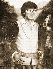
 During the Napoleonic Occupation of Spain, Miguel Hidalgo y Costilla, a Catholic priest of progressive ideas, declared Mexican independence in the small town of Dolores, Guanajuato on September 16, 1810 with a proclamation known as the "Grito de Dolores". Hidalgo built a large support among intellectuals, liberal priests and many poor people. Hidalgo fought to protect the rights of the poor and indigenous population. He started on a march to the capital, Mexico City
, but retreated back north when faced with the elite of the royal forces at the outskirts of the capital. He established a liberal government from Guadalajara, Jalisco
but was soon forced to flee north by the royal forces that recaptured the city. Hidalgo attempted to reach the United States and gain American support for Mexican independence. HIdalgo reached Saltillo
, Coahuila
where he publicly resigned his military post and rejected a pardon offered by Viceroy
Francisco Venegas
in return for Hidalgo's surrender. A short time later, he and his supporters were captured by royalist Ignacio Elizondo
at the Wells of Baján (Norias de Baján) on March 21, 1811 and taken to the city of Chihuahua. Hidalgo forced the Bishop of Valladolid, Manuel Abad y Queipo
, to rescind the excommunication
order he had circulated against him on September 24, 1810. Later, the Inquisition issued an excommunication edict on October 13, 1810 condemning Miguel Hidalgo as a seditionary, apostate, and heretic
.
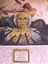
Hidalgo was turned over to the Bishop of Durango
, Francisco Gabriel de Olivares, for an official defrocking
and excommunication on July 27, 1811. He was then found guilty of treason by a military court and executed by firing squad on July 30 at 7 in the morning. Before his execution, he thanked his jailers, Private Soldiers Ortega and Melchor, in letters for their humane treatment. At his execution, Hidalgo placed his right hand over his heart to show the riflemen where they should aim. He also refused the use of a blindfold. His body, along with the bodies of Allende, Aldama and José Mariano Jiménez
were decapitated, and the heads were put on display on the four corners of the Alhóndiga de Granaditas
in Guanajuato
. The heads remained there for ten years until the end of the Mexican War of Independence
to serve as a warning to other insurgents. Hidalgo's headless body was first displayed outside the prison but then buried in the Church of St Francis
in Chihuahua. Those remains would later be transferred in 1824 to Mexico City.
 Hidalgo's death resulted in a political vacuum on the insurgent side until 1812. The royalist military commander, General Felix Calleja, continued to pursue rebel troops. Insurgent fighting evolved into guerrilla warfare, and eventually the next major insurgent leader, Jose Maria Morelos y Pavon
, who had led rebel movements with Hidalgo, became head of the insurgents.
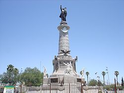
Hidalgo is hailed as the Father of the Nation even though it was Agustin de Iturbide
and not Hidalgo who achieved Mexican Independence in 1821. Shortly after gaining independence, the day to celebrate it varied between September 16, the day of Hidalgo's Grito and September 27, the day Iturbide rode into Mexico City to end the war. Later, political movements would favor the more liberal Hidalgo over the conservative Iturbide, so that eventually September 16, 1810 became the officially recognized day of Mexican independence. The reason for this is that Hidalgo is considered to be "precursor and creator of the rest of the heroes of the (Mexican War of) Independence." Hidalgo has become an icon for Mexicans who resist tyranny in the country. Diego Rivera
painted Hidalgo's image in half a dozen murals. José Clemente Orozco
depicted him with a flaming torch of liberty and considered the painting among his best work. David Alfaro Siqueiros
was commissioned by San Nicolas University in Morelia to paint a mural for a celebration commemorating the 200th anniversary of Hidalgo's birth. The town of his parish was renamed Dolores Hidalgo in his honor and the state of Hidalgo was created in 1869. Every year on the night of 15–16 September, the president of Mexico re-enacts the Grito from the balcony of the National Palace
. This scene is repeated by the heads of cities and towns all over Mexico. The remains of Miguel Hidalgo y Costilla lie in the column of the Angel of Independence
in Mexico City. Next to it is a lamp lit to represent the sacrifice of those who gave their lives for Mexican Independence.
and liberal
elements formed using the nicknames of Chirrines and Cuchas. The military entered as a third party. The elections for the first regular legislature were disputed, and it was not until May 1, 1826, that the body was installed. The liberals gained control and the opposition responded by fomenting a conspiracy. This was promptly stopped with the aid of informers, and more strenuous measures were taken against the conservatives. Extra powers were conferred on the Durango governor, Santiago Baca Ortiz, deputy to the first national congress, and leader of the liberal party.
. When elections failed, the government intervened in favor of the Yorkino
party, which had elected Vicente Guerrero
to the presidency.
Because of the general instability of the federal government during 1828, the installation of the new legislature did not take place until the middle of the following year. It was quickly dissolved by Governor Santiago de Baca Ortiz, who replaced it with a more pronounced Yorkino type. When Guerrero's liberal administration was overthrown in December, Gaspar de Ochoa aligned with Anastasio Bustamante
, and in February 1830, organized an opposition group that arrested the new governor, F. Elorriaga, along with other prominent Yorkinos. He then summoned the legislature, which had been dissolved by Baca. The civil and military authorities were now headed by J. A. Pescador and Simón Ochoa.
, was induced to remain there. José Antonio Arcé took his place as ruler in Chihuahua. In 1829, González became general commander of Chihuahua, when his term of office on the west coast expired. Arcé was less of a yorkino than his confrere of Durango. Although unable to resist the popular demand for the expulsion of the Spaniards, he soon quarreled with the legislature, which declared itself firmly for Guerrero
, and announcing his support of Bustamante
's revolution, he suspended, in March 1830, eight members of that body, the vice-governor, and several other officials, and expelled them from the state. The course thus outlined was followed by Governor José Isidro Madero, who succeeded in 1830, associated with J. J. Calvo as general commander, stringent laws being issued against secret societies, which were supposed to be the main spring to the anti-clerical feeling among liberals.
supported the initial reaction against the government at Mexico. In May 1832, José Urrea, a rising officer, supported the restoration of President Pedraza
. On July 20, Governor Elorriaga was reinstated, and Baca along with the legislative minority were brought back to form a new legislature, which met on September 1. Chihuahua showied no desire to imitate the revolutionary movement and Urrea prepared to invade the state. Comandante-general J.J.Calvo threatened to retaliate, and a conflict seemed imminent. The entry of General Santa Anna into Mexico brought calm, as the leaders waited for clarity.
was in power. Because the plan was not enforced, commanding officer, Colonel J.I. Gutiérrez, declared the term of the legislature and governor expired on September 3.
At a convention of citizens called to select a new provisional ruler, Gutierrez obtained the vote, with P. J. Escalante for his deputy, and a council to guide the administration. Santa Anna ordered the reinstatement of Mendarozqueta as comandante general. Gutiérrez yielded, but Escalante refused to surrender office, demonstrations of support ensued, but Escalante yielded when troops were summoned from Zacatecas
. A new election brought a new legislature, and conforming governors. In September 1835 José Urrea a federalist army officer came into power.
Comandante general Simón Elías González, was nominated governor and military command was given to Colonel J.J. Calvo, whose firmness had earned well-merited praise. The state was in the midst of a war with the Apache
s, which became the focus of all their energy and resources. After a review of the situation, Simón Elías González declared that the interests of the territory would be best served by uniting the civil and military power, at least while the campaign lasted. He resigned under opposition, but was renominated in 1837.
The United States Congress declared war on Mexico on May 13, 1846 after only having a few hours to debate. Although President José Mariano Paredes's issuance of a manifesto on May 23 is sometimes considered the declaration of war, Mexico officially declared war by Congress on July 7. After the American invasion of New Mexico, Chihuahua sent 12,000 men led by Coronel Vidal to the border to stop the American military advance into the state. The Mexican forces being impatient to confront the American forces passed beyond El Paso del Norte about 20 miles (32.2 km) north along the Rio Grande. The first battle that Chihuahua fought was the battle of El Bracito; the Mexican forces consisting of 500 cavalry and 70 infantry confronted a force of 1100–1200 Americans on December 25, 1846. The battle ended badly by the Mexican forces that were then forced to retreat back into the state of Chihuahua. By December 27, 1846, the American forces occupied El Paso Del Norte. General Doniphan maintained camp in El Paso Del Norte awaiting supplies and artillery which he received in February 1847.
On February 8, 1847, Doniphan continued his march with 924 men mostly from Missouri; he accompanied a train of 315 wagons of a large commercial caravan heading to the state capital. Meanwhile, the Mexican forces in the state had time to prepare a defense against the Americans. About 20 miles (32.2 km) north of the capital where two mountain ranges join from east to west is the only pass into the capital; known as Sacramento Pass, this point is now part of present-day Chihuahua City. The Battle of Sacramento was the most important battle fought in the state of Chihuahua because it was the sole defense for the state capital. The battle ended quickly because of some devastating defensive errors from the Mexican forces and the ingenious strategic moves by the American forces. After their loss at the Battle of Sacramento, the remaining Mexican soldiers retreated south, leaving the city to American occupation. Almost 300 Mexicans were killed in the battle, as well as almost 300 wounded. The Americans also confiscated large amounts of Mexican supplies and took 400 Mexican soldiers prisoners of war. American forces maintained an occupation of the state capital for the rest of the Mexican American War.
The Treaty of Guadalupe Hidalgo, signed on February 2, 1848, by American diplomat Nicholas Trist and Mexican plenipotentiary representatives Luis G. Cuevas, Bernardo Couto, and Miguel Atristain, ended the war, gave the U.S. undisputed control of Texas, and established the U.S.–Mexican border of the Rio Grande. As news of peace negotiations reached the state, new call to arms began to flare among the people of the state. But as the Mexican officials in Chihuahua heard that General Price was heading back to Mexico with a large force comprising several companies of infantry and three companies of cavalry and one division of light artillery from Santa Fe on February, 8 1848, Ángel Trías sent a message to Sacramento Pass to ask for succession of the area as they understood the war had concluded. General Price, misunderstanding this as a deception by the Mexican forces, continued to advance towards the state capital. On March 16, 1848 Price began negotiations with Ángel Trías, but the Mexican leader responded with an ultimatum to General Price. The American forces engaged with the Mexican forces near Santa Cruz de los Rosales on March 16, 1848. The Battle of Santa Cruz de los Rosales was the last battle of the Mexican–American War and it occurred after the peace treaty was signed. The American forces maintained control over the state capital for three months after the confirmation of the peace treaty. The American presence served to delay the possible succession of the state which had been discussed at the end of 1847, and the state remained under United States occupation until May 22, 1848.
During the American occupation of the state, the number of Indian attacks was drastically reduced, but in 1848 the attacks resumed to such a degree that the Mexican officials had no choice but to resume military projects to protect Mexican settlements in the state. Through the next three decades the state faced constant attacks from indigenous on Mexican settlements. After the occupation the people of the state were worried about the potential attack from the hostile indigenous tribes north of the Rio Grande; as a result a decree on July 19, 1848 the state established 18 military colonies along the Rio Grande. The new military colonies were to replace the presidios as population centers to prevent future invasions by indigenous tribes; these policies remained prominent in the state until 1883. Eventually the state replaced the old state security with a state policy to form militias organized with every Mexican in the state capable to serve between the ages of 18 and 55 to fulfill the mandate of having six men defending for every 1000 residents.
, but were soon disappointed by the federal governments decision to deploy military forces to other areas of the country due to internal challenges in the state of Jalisco
. Ángel Trías led a rebellion to successfully depose the unpopular conservative Governor Cordero at the end of 1852.
Despite the efforts of strong political forces lea by Ángel Trías in the state could not stop President Santa Anna from selling La Mesilla
as part of the Gadsden Purchase
on December 30, 1853 for 15 million USD. It was then ratified in the United States on April 25, 1854 and signed by President Franklin Pierce
, with final approval action taken by Mexico on June 8, 1854. The citizens of the area held strong anti-American sentiments and raided American settlers and travelers across the area.
and ratified the new constitution in 1855. The state was able to survive through the Reform War
with minimal damage due to the large number of liberal political figures. The 1858 conservative movement did not succeed in the state even after the successful military campaign of the conservative Zuloaga with 1,000 men occupied the cities of Chihuahua and Parral. In August 1859, Zuloaga and his forces were defeated by the liberal Orozco and his forces; Orozco soon after deposed the state governor, but had to flee to Durango two months later. In late 1860s the conservative General Cajen briefly entered the state after his campaign through the state of Jalisco and helped establish conservative politicians and ran out the liberal leaders Jesús González Ortega and José María Patoni. Cajen took possession of the state capital and established himself as governor; he brooked no delay in uniting a large force to combat the liberal forces which he defeated in La Batalla del Gallo. Cajen attained several advantages over the liberals within the state, but soon lost his standing due to a strong resurgence of the liberal forces within the state. The successful liberal leaders José María Patoni of Durango and J.E. Muñoz of Chihuahua quickly strengthened their standing by limiting the political rights of the clergy implementing the presidential decree. The state elected General Luis Terrazas
, a liberal leader, as governor; he would continue to fight small battles within the state to suppress conservative uprisings during 1861.
In consequence to the Reform War, the federal government was bankrupt and could not pay its foreign debts to Spain, England, and France. On July 17, 1861, President Juárez decreed a moratorium on payment to foreign debtors for a period of two years. Spain, England, and France did not accept the moratorium by Mexico; they united at the Convention of the Triple Alliance on October 31, 1861 in which they agreed to take possession of several custom stations within Mexico as payment. A delegation of the Triple Alliance arrived in Veracruz in December 1861. President Juárez immediately sent his Foreign Affairs Minister, Manuel Doblado
, who is able to reduce the debts through the Pacto de Soledad (Soledad Pact). General Juan Prim
of Spain persuaded the English delegation to accept the terms of the Pacto de Soledad, but the French delegation refused.
The liberal political forces maintained strong control over the state government until shortly after the French Intervention which turned the tables in favor to the conservative forces once again. The intervention had serious repercussions for the state of Chihuahua. President Juárez, in an effort to organize a strong defense against the French, decreed a list of national guard units that every state had to contribute to the Ministry of War and the Navy; Chihuahua was responsible for inducting 2,000 men. Regaining power, Governor Luis Terrazas
assigned the First Battalion of Chihuahua for integration into the national army led by General Jesús González Ortega; the battalion was deployed to Puebla. After the defeat of the army in Puebla, the Juárez administration was forced to abandon Mexico City; the president retreated further north seeking refuge in the state of Chihuahua.
Under threat from the conservative forces, Governor Terrazas was deposed, and the state legislature proclaimed martial law in the state in April 1864 and established Jesús José Casavantes as the new governor. In response, José María Patoni decided to march to Chihuahua with presidential support. Meanwhile, Maximilian von Habsburg, a younger brother of the Emperor of Austria, was proclaimed Emperor Maximilian I
of Mexico on April 10, 1864 with the backing of Napoleon III and a group of Mexican conservatives. Before President Benito Juárez
was forced to flee, Congress granted him an emergency extension of his presidency, which would go into effect in 1865 when his term expired, and last until 1867. At the same time, the state liberals and conservatives compromised to allow the popular Ángel Trías take the governorship; by this time the French forces had taken control over the central portions of the country and were making preparations to invade the northern states.
The French forces tried to subdue and capture the liberal government based in Saltillo
. On September 21, 1864, José María Patoni and Jesús González Ortega lost against the French forces at the Battle of Estanzuelas; the supreme government led by President Juárez was forced to evacuate the city of Saltillo
and relocate to Chihuahua. Juárez stopped in Ciudad Jiménez
, Valle de Allende
, and Hidalgo de Parral
, in turn. He decreed Parral the capital of Mexico from October 2–5, 1864. Perceiving the threat from the advancing French forces, the president continued his evacuation through Santa Rosalía de Camargo, Santa Cruz de Rosales
, and finally Chihuahua City
. On October 12, 1864, the people of the state gave President Juárez an overwhelmingly supportive reception, led by Governor Ángel Trías. On October 15, 1864 the city of Chihuahua was declared the temporary capital of Mexico.
After running imperial military affairs in the states of Coahuila and Durango, General Agustín Enrique Brincourt
made preparations to invade the state of Chihuahua. On July 8, 1865 Brincourt crossed the Nazas River
in northern Durango, heading toward Chihuahua. On July 22 Brincourt crossed the banks of Río Florido into Ciudad Jiménez; one day later he arrived at Valle de Allende where he sent Colonel Pyot with a garrison to take control of Hidalgo del Parral. Brincourt continued through Santa Rosalia de Camargo and Santa Cruz de Rosales. President Juárez remained in the state capital until August 5, 1865 when he left for El Paso del Norte (present-day Ciudad Juárez
) due to evidence that the French were to attack the city. On the same day, the President named General Manuel Ojinaga the new governor and placed him in charge of all the republican forces. Meanwhile, General Villagran surprised the imperial forces in control of Hidalgo de Parral; after a short two hour battle, Colonel Pyot was defeated and forced to retreat. At the Battle of Parral, the French lost 55 men to the Republican forces. On August 13, 1865, the French forces with an estimated 2,500 men arrived at the outskirts of Chihuahua City, and on August 15, 1865, General Brincourt defeated the republican forces, taking control of the state capital. Brincourt designated Tomás Zuloaga as Prefect of Chihuahua. Fearing the French would continue their campaign to El Paso del Norte, President Juárez relocated to El Carrizal
, a secluded place in the mountains near El Paso del Norte, in August 1865, . It would have been easy for the French forces to continue in pursuit of President Juárez across the border, but they feared altercations with American forces. General François Achille Bazaine
ordered the French troops to retreat back to the state of Durango after only reaching a point one days travel north of Chihuahua City. General Brincourt asked for 1,000 men to be left behind to help maintain control over the state, but his request was denied. After the death of General Ojinaga, the Republican government declared General Villagran in charge of the fight against the Imperial forces. The French left the state on October 29, 1865. President Juárez returned to Chihuahua City on November 20, 1865 and remained in the city until December 9, 1865 when he returned to El Paso del Norte. Shortly after the president left Chihuahua City, Terrazas
was restored as governor of the state on December 11, 1865.
Maximilian was deeply dissatisfied with General Bazaine's decision to abandon the state capital of Chihuahua and immediately ordered Agustín B. Billaut to recapture the city. On December 11, 1865, Billaut with a force of 500 men took control of the city. By January 31, 1866 Billaut was ordered to leave Chihuahua, but he left behind 500 men to maintain control. At the zenith of their power, the imperialist forces controlled all but four states in Mexico; the only states to maintain strong opposition to the French were: Guerrero, Chihuahua, Sonora, and Baja California.
 President Juárez once again based his government in the state of Chihuahua and it served as the center for the resistance against the French invasion throughout Mexico. On March 25, 1866, a battle ensued in the Plaza de Armas in the center of Chihuahua City between the French imperial forces that were guarding the plaza and the Republican forces led by General Terrazas. Being completely caught off guard, the French imperial forces sought refuge by bunkering themselves in the Cathedral of the Holy Cross, Our Lady of Regla, and St Fancis of Assisi
and made it almost impossible to penetrate their defenses. General Terrazas then decided to fire a heavy artillery barrage with 8 kg cannon balls. The first cannon fired hit a bell in the tower of the church, instantly breaking it in half; soon after, 200 men of the imperial army forces surrendered. The republican forces had recovered control over the state capital. The bell in the church was declared a historical monument and can be seen today in the Cathedral. By April 1866, the state government had established a vital trading route from Chihuahua City to San Antonio, Texas; the government began to replenish their supplies and reinforce their fight against the Imperial forces.
General Aguirre moved to the deserts of the southeastern portion of the state and defeated the French forces in Parral, led by Colonel Cottret. By the middle of 1866, the state of Chihuahua was declared free of enemy control; Parral was the last French stronghold within the state. On June 17, 1866, President Juárez arrived in Chihuahua City and remained in the capital until December 10, 1866. During his two years in the state of Chihuahua, President Juárez passed ordinances regarding the rights of adjudication of property and nationalized the property of the clergy. The distance of the French forces and their allies allowed the Ministry of War, led by General Negrete, to reorganize the state's national guard into the Patriotic Battalion of Chihuahua, which was deployed to fight in the battle of Matamoros, Tamaulipas
against the French. After a series of major defeats and an escalating threat from Prussia, France began pulling troops out of Mexico in late 1866. Disillusioned with the liberal political views of Maximilian, the Mexican conservatives abandoned him, and in 1867 the last of the Emperor's forces were defeated. Maximilian was sentenced to death by a military court; despite national and international pleas for amnesty, Juárez refused to commute the sentence. Maximilian was executed by firing squad on June 19, 1867.
 President Benito Juárez was re-elected in the general election of 1867 in which he received strong liberal support, especially in Chihuahua. Luis Terrazas was confirmed by the people of Chihuahua to be governor of the state. But soon after the election, President Juárez had another crisis on his hands; the Juárez administration was suspected to be involved in the assassination of the military chief José María Patoni executed by General Canto in August 1868. General Canto turned himself over to Donato Guerra
. Canto was sentenced to death, but later his sentence changed to 10 years imprisonment. The sense of injustice gave rise to a new rebellion in 1869 that threatened the federal government. In response, the Juárez administration took drastic measures by temporarily suspending constitutional rights, but the governor of Chihuahua did not support this action. Hostilities continued to increase especially after the election of 1871 which was perceived to be fraudulent. A new popular leader arose among the rebels, Porfirio Díaz. The federal government was successful in quelling rebellions in Durango an Chihuahua. On July, 18 1872, President Juárez died from a heart attack; soon after, many of his supporters ceased the fighting. Peace returned to Chihuahua and the new government was led by Governor A. Ochoa in 1873 after Luis Terrazas finished his term in 1872.
But the peace in the state did not last long, the elections of 1875 caused new hostilities. Ángel Trías led a new movement against the government on June 1875 and maintained control over the government until September 18, 1875 when Donato Guerra
the orchestrator of the Revolution of the North was captured. Donato Guerra was assassinated in a suburb of Chihuahua City where he was incarcerated for conspiring with Ángel Trías. During October 1875 several locations were controlled by rebel forces, but the government finally regained control on November 25, 1875.
 After the death of the president Benito Juárez in 1872, the first magistracy of the country was occupied by the vice-president Sebastián Lerdo de Tejada, who called for new elections. Two candidates were registered; Lerdo de Tejada and General Porfirio Díaz
, one of the heroes of the Battle of Puebla
which had taken place on May 5, 1862. Lerdeo de Tejada won the election, but lost popularity after he announced his intent to run for re-election. On March 21, 1876, Don Porfirio Díaz rebelled against President Sebastian Lerdo de Tejada. The Plan of Tuxtepec
defended the "No Re-election" principle. On June 2, 1876 the garrisons in the state of Chihuahua surrendered to the authority of General Porfirio Díaz; Governor Antonio Ochoa was arrested until all the Lerdista forces were suppressed throughout the state. Porfirio Díaz then helped Tíras regain the governorship of the state of Chihuahua allowing for the Plan of Tuxtepec to be implemented. The victory of the Plan of Tuxtepec, gave the interim presidency to Jose Maria Iglesias and later, as the only candidate, the General Porfirio Díaz assumed the presidency on May 5, 1877.
During the first years of the Porfiriato (Porfirio Díaz Era), the Díaz administration had to combat several attacks from the Lerdista forces and the Apache. A new rebellion led by the Lerdista party was orchestrated from exile in the United States. The Lerdista forces were able to temporarily occupy the city of El Paso del Norte until mid 1877. During 1877 the northern parts of the state suffered through a spell of extreme drought which were responsible for many deaths in El Paso del Norte.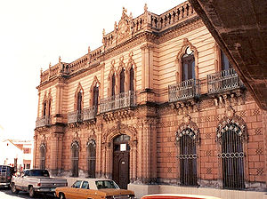 The officials in Mexico City reduced the price of corn from six cents to two cents a pound. The northern portion of the state continued to decline economically which led to another revolt led by G. Casavantes in August 1879; Governor Trías was accused of misappropriation of funds and inefficient administration of the state. Casavantes took the state capital and occupied it briefly; he was also successful in forcing Governor Trías to exile. Shortly afterwards, the federal government sent an entourage led by Treviño; Casavantes was immediately ordered to resign his position. Casavantes declared political victory as he was able to publicly accuse and depose Governor Trías. At the same time the states of Durango and Coahuila had a military confrontation over territorial claims and water rights; this altercation between the state required additional federal troops to stabilize the area. Later a dispute ensued again between the states of Coahuila, Durango, and Chihuahua over the mountain range area known as Sierra Mojada when large deposits of gold ore was discovered. The state of Chihuahua officially submitted a declaration of protest in May 1880 that was shortly after settled amicably. Despite the difficulties at the beginning, Díaz was able to secure and stabilize the state which earned the confidence and support of the people.
During the 1880s, the Díaz administration consolidated several government agencies throughout Mexico to control credit and currency by the creation of the Institution of Credit and Currency. Because Díaz had created such an effective centralized government, he was able to concentrate decision-making and maintain control over the economic instability. The Díaz administration made political decision and took legal measures that allowed the elite throughout Mexico to concentrate the nation's wealth by favoring monopolies. During this time, two fifths of the state's territory was divided among 17 rich families which owned practically all of the arable land in Chihuahua. The state economy grew at a rapid pace during the Porfiriato; the economy in Chihuahua was dominated by agriculture and mining. The Díaz administration helped Governor Luis Terrazas
by funding the Municipal Public Library in Chihuahua City and passing a federal initiative for the construction of the railroad from Chihuahua City to Ciudad Júarez. By 1881, the Central Mexican Railroad was completed which connected Mexico City to Cuidad Júarez. In 1883 telephone lines are installed throughout the state allowing communication between Chihuahua City and Aldama. By 1888 the telephone services were extended from the capital to the cites of Julimes, Meoqui, and Hidalgo del Parral; the telecommunication network in the state covered an estimated 3,500 kilometers. Due to the need of labor to construct the extensive infrastructure projects, a significant Asian immigration is observed in the state; most of the immigrants came from China. Asian immigrants soon become integral parts of the state economy by opening restaurants, small grocery stores, and hotels. By the end of the Terrazas term, the state experiences an increase in commerce, mining, and banking. The banks in the state are overtaken by the federal government which made Chihuahua the most important banking state in Mexico.
Under Governor Miguel Ahumada, the education system in the state is unified and brought under tighter control by the state government, and the metric system is standardized throughout the state which replaces the colonial system of weights and measurements. On September 16, 1897 the Civilian Hospital of Chihuahua is inaugurated in Chihuahua City which became known as one of the best in the country. In 1901 the Hero's Theatre is opened in Chihuahua City. On August 18, 1904 Governor Terrazas is replaced by Governor Enrique C. Creel. From 1907 to 1911, the Creel administration is successful in advancing the state's legal system, modernizing the mining industry, and raising public education standards. In 1908 the Chihuahuan State Penitentiary is built, and the construction on the first large scale dam project is initiated on the Chuviscar River. During the same time, the streets of Chihuahua City are paved and numerous monuments are built in Chihuahua City and Ciudad Júarez.
. The economy was characterized by the construction of factories, roads, dams, and better farms. The Díaz administration passed new land laws that virtually unraveled all the rights previously recognized and the land reforms passed by President Benito Júarez. No peasant or farmer could claim the land he occupied without formal legal title. A handful of families owned large estates (known as haciendas
)and controlled the greater part of the land across the state while the vast majority of Chihuahuans were landless. The state economy was largely defined by ranching and mining. At the expense of the working class
, the Díaz administration promoted economic growth by encouraging investment from foreign companies from the United Kingdom, France, Imperial Germany and the United States. The proletariat
was often exploited, and found no legal protection or political recourse to redress injustices.
Despite the internal stability (known as the "paz porfiriana"), modernization, and economic growth in Mexico during the Porfiriato from 1876 to 1910, many across the state became deeply dissatisfied with the political system. When Díaz first ran for office, he committed to a strict “No Re-election” policy in which he disqualified himself to serve consecutive terms. Eventually backtracking on many of his initial political positions Díaz became a de facto dictator. Díaz became increasingly unpopular due to brutal suppression of political dissidents by using the Rurales
and manipulating the elections to solidify his political machine. The working class was frustrated with the Díaz regime due to the corruption of the political system that had increased the inequality between the rich and poor. The peasants felt disenfranchised by the policies that promoted the unfair distribution of land where 95% of the land was owned by the top 5%.
 The state of Chihuahua is the largest state in the country and is known as El Estado Grande (The Big State); it accounts for 12.6% of the land of Mexico. The state landlocked by the states of Sonora to the west, Sinaloa to the south-west, Durango to the south, and Coahuila to the east, and by the U.S. states of Texas to the north-east and New Mexico to the north. The state is made up of three geologic regions: Mountains, Plains-Valleys, and Desert which occur in large bands from west to east. Because of the different geologic regions there are contrasting climates and ecosystems.
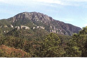
The main mountain range in the state is the Sierra Madre Occidental
reaching a maximum altitude of 10,826 ft (3,300 m) known as Cerro Mohinora
. Mountains account for one third of the state's surface area which include large coniferous forests. The climate in the mountainous regions varies Chihuahua has more forests than any other state in Mexico making the area a bountiful source of wood; the mountainous areas are rich in minerals important to Mexico's mining industry. Precipitation and temperature in the mountainous areas depends on the elevation. Between the months of November and March snow storms are possible in the lower elevations and are frequent in the higher elevations. There are several watersheds located in the Sierra Madre Occidental all of the water that flows through the state; most of the rivers finally empty into the Rio Grande
. Temperatures in some canyons in the state reach over 100°F in the summer while the same areas rarely drop below 32°F in the winter. There are microclimates found in the heart of the Sierra Madre Occidental in the state that could be considered tropical and there have been wild tropical plants found in some canyons. La Barranca del Cobre, or Copper Canyon
, a spectacular canyon system larger and deeper than the Grand Canyon
; the canyon also contains Mexico's two tallest waterfalls: Basaseachic Falls
and Piedra Volada
. There are two national parks found in the mountainous area of the state: Cumbres de Majalca National Park
and Basaseachic Falls National Park
.
The plains at the foot of the Sierra Madre Occidental is an elongated mesa known as Altiplanicie Mexicana that exhibits a steppe climate and serves as a transition zone from the mountain climate in the western part of the state to the desert climate in the eastern side of the state.
The steppe zone accounts for a third of the state's area, and it experiences pronounced dry and wet seasons. The pronounced rainy season in the steppe is usually observed in the months of July, August, and September. The steppe also encounters extreme temperatures that often reach over 100°F in the summer and drop below 32°F in the winter. The steppe zone is an important agriculture zone due to an extensive development of canals exploiting several rivers that flow down from the mountains. The steppe zone is the most populated area of the state.
The most important river in the state is Rio Conchos
which is the largest tributary to the Rio Grande
from the Mexican side; the river descends from the zenith of the Sierra Madre Occidental in the southwest part of the state an winds through the center of the state where the water is exploited in the steppe zone and it eventually empties into the Rio Grande in the small desert town of Ojinaga
.
The desert zone also accounts for about a third of the state's surface area. The Chihuahuan Desert
is an international biome that also extends into the neighboring Mexican state of Coahuila
and into the US states of Texas
and New Mexico
. The desert zone is mainly of flat topography with some small mountain ranges that run north to south. The desert in the state varies slightly with a small variant in climate. The lower elevations of the desert zone are found in the north along the Rio Grande which experience hotter temperatures in the summer and winter while the southern portion of the desert zone experiences cooler temperatures due to its higher elevation. Samalayuca covers an area of about 150 square kilometers; it is an impressive site of the Chihuahuan Desert
and is a protected area by the state due to unique species of plants and animals that can only be found in that area.
the state has five major climate zones. The Sierra Madre Occidental
dominates the western part of the state; there are two main climates in this area: Subtropical Highland
(Cfb) and Humid Subtropical (Cwa). There are some microclimates in the state due to the varying topology mostly found in the western side of the state. The two best known microclimates are: Tropical savanna climate
(Aw) in deep canyons located in the extreme southern part of the state; Continental Mediterranean climate (Dsb) in the extremely high elevations of the Sierra Madre Occidental. Satellite image to the right shows the vegetation is much greener in the west because of the cooler temperatures and larger amounts of precipitation as compared to the rest of the state.
In the far eastern part of the state the Chihuahuan Desert
dominates due to low precipitation and extremely high temperatures; some areas of the eastern part of the state are so dry no vegetation is found like the Sand Dunes of Samalayuca. There are two distinctive climate zones found in the eastern part of the state: Hot Desert (BWh) and Cool Desert (BWk) which are differentiated by average annual temperature due to differences in elevation. There is a transition zone in the middle of the state between the two extremely different climates from the east and west; this zone is the Steppe
characterized by a compromise between juxtaposed climate zones.
----
 The state has a great diversity due to the large number of microclimates found and dramatic varying terrain. The flora throughout the Sierra Madre Occidental
mountain range varies with elevation. Pine (Pinus) and Oak (Quercus) species are usually found at an elevation of 2,000 meters (6,560 ft) above sea level. The most common species of flora found in the mountains are: Pinus, Quercus, Abies, Ficus
, Vachellia
, Ipomoea
, Acacia
, Lysiloma
, Bursera
, Vitex
, Tabebuia
, Sideroxylon
, Cordia
, Fouquieria
, Pithecellobium
. The state is home to one of the largest variation species of the genus Pinus in the world. The lower elevations have a steppe vegetation with a variety of grasses and small bushes. Several species of Juniperus dot the steppe and the transition zone.
According to the World Wide Fund for Nature
, the Chihuahuan Desert may be the most biologically diverse desert in the world, whether measured on species richness or endemism, although the region has been heavily degraded over time. Many native species have been replaced with creosote shrubs. The most common desert flora in the state includes: Agave
, Larrea
, Prosopis
, Fouquieria
, Dasylirion
, Yucca
, Poaceae
, Lophophora
, Opuntia
, Echinocereus
, Baileya, Chilopsis
, Eucnide
, and Hylocereus
.
The fauna in the state is just as diverse as the flora and varies greatly due to the large contrast in climates. In the mountain zone of the state the most observed mammals are: Mexican Fox Squirrel (Sciurus nayaritensis), Antelope Jackrabbit (Lepus alleni), Raccoon (Procyon lotor), Hooded Skunk (Mephitis macroura), Wild Boar (Sus scrofa), Collared Peccary (Pecari tajacu), White-tailed Deer (Odocoileus virginianus), Mule Deer Odocoileus hemionus, American bison Bison bison, Cougar (Puma concolor), Eastern Cottontail Sylvilagus floridanus, North American Porcupine Erethizon dorsatum, Bobcat Lynx rufus, ; Mexican Wolf Canis lupus baileyi, and Coyote Canis latrans. American Black BearUrsus americanus is also found but in very small numbers. The Mexican wolf
, once abundant, has been extirpated. The main cause of degradation has been grazing. Although there are many reptilian species in the mountains the most observed species include: Northern Mexican Pine Snake, Pituophis deppei jani, Texas Horned Lizard (Phrynosoma cornutum), Rock Rattlesnake (Crotalus lepidus
), Black-tail Rattlesnake (Crotalus molossus
). Plateau Tiger Salamander Ambystoma velasci is one of possible many amphibians to be found in the mountains.
 The Chihuahuan Desert is home to a diverse ecosystem which is home to a large variety of mammals. The most common mammals in the desert include: Desert Cottontail Sylvilagus audubonii; Black-tailed Jackrabbit Lepus californicus; Hooded Skunk Mephitis macroura; Cactus Mouse Peromyscus eremicus; Swift Fox Vulpes velox; White-Throated Woodrat Neotoma albigula; Pallid bat Antrozous pallidus; and Coyote Canis latrans. The most observed reptiles in the desert include: Mohave rattlesnake Crotalus scutulatus
, Twin-spotted rattlesnake Crotalus pricei
, Prairie rattlesnake Crotalus viridis
, Ridge-nosed rattlesnake Crotalus willardi
; Whip Snake Masticophis flagellum
; New Mexico Whiptail Cnemidophorus neomexicanus
; Red-spotted Toad Bufo punctatus
.
The state is also a host to a large population of birds which include endemic species and migratory species: Greater Roadrunner Geococcyx californianus; Cactus Wren Campylorhynchus brunneicapillus; Mexican Jay Aphelocoma ultramarina; Steller's Jay Cyanocitta stelleri; Acorn Woodpecker Melanerpes formicivorus; Canyon Towhee Pipilo fuscus; Mourning Dove Zenaida macroura; Broad-billed Hummingbird Cynanthus latirostris; Montezuma Quail Cyrtonyx montezumae; Mountain Trogon Trogon mexicanus; Turkey Vulture Cathartes aura; and Golden Eagle Aquila chrysaetos. Trogon mexicanus is endemic species found in the mountains in Mexico; it is considered an endangered species and has symbolic significance to Mexicans.
According to the census by the Instituto Nacional de Estadística y Geografía (INEGI) in 2005, the state population is 3,241,444 making the state the 11th most populated state in Mexico. Census recorded 1,610,275 men and 1,631,169 women. The median age of the population is 25 years of age. The northern state is placed seventh in the nation regarding quality of life and sixth in terms of life expectancy at 75.2 years of age.
During the period from 2000–2005 it is estimated that 49,722 people left the state for the United States. 82,000 people are thought to have immigrated to the state from 2000–2005 mainly coming from Veracruz
(17.6%), United States (16.2%), Durango (13.2%), Coahuila
(8.0%) y Chiapas
(4.5%). It is believed that there is a large number of undocumented immigrants in that state the come from Central and South America which mainly settle in Ciudad Juárez
. According the to the 2005 census, the population grew 1.06% from 2000 to 2005. The state has an uneven settlement of people and the lowest population density of any Mexican state; according to the 2005 census there were 12 people per square kilometer. Of all the 3,241,444 people in the state, two thirds live in the cities of Ciudad Juárez
and Chihuahua
accounting together 2,072,129. Only three cities have more than one hundred thousand: Parral
101,147; Cuauhtémoc 105,725; and Delicias
108,187.
make up 55% of the population, most of them of Spanish
origin, but also of French
, Basque
, Italian
, German, Dutch
and Middle Eastern descent, while the rest of the population are Mestizo
groups of predominantly Spanish descent. Indians form 5% of the state inhabitants and remain isolated in the forests of southwestern Chihuahua. The admixture with Indians was never sizable in Nueva Vizcaya
due to the scarcity of natives (most of them warrior and anti-European Conchos and Tarahumaras), and the size of the territory. The most important indigenous tribes of the state of Chihuahua are:
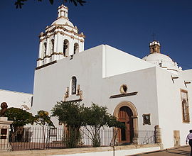
 Although the great majority of residents of the state of Chihuahua are Catholics, there is a large diversity of religions within the state. There are many apostolic churches, LDS churches, and large Mennonite communities.
Population of 5 years and older claim to be the following religious beliefs.
comprise one of the largest bi-national metropolitan areas in the world with a combined population of 2.4 million people. In fact, Ciudad Juárez is one of the fastest growing cities in the world in spite of the fact that it is "the most violent zone in the world outside of declared war zones." For instance, a few years ago the Federal Reserve Bank of Dallas
published that in Ciudad Juárez "the average annual growth over the 10-year period 1990–2000 was 5.3 percent. Juárez experienced much higher population growth than the state of Chihuahua and than Mexico as a whole."
Chihuahua City has one of the highest literacy rates in the country at 98%; 35% of the population is aged 14 or below, 60% between 15-65 and 5% over 65. The growth rate is 2.4%.
The 76.5% of the population of the state of Chihuahua live in cities which makes the state one of the most urbanized in Mexico.
Institutions of higher education include:
has recently been the scene of Mexico's most violent confrontations between rival drug cartels.
Chihuahua is subdivided into 67 municipios (municipalities
).
or 29,826 million USD. Chihuahua's economy has a strong focus on export-oriented manufacturing (i.e. maquiladora
). As of 2005, 329,939 people are employed in the manufacturing sector. There are a more than 406 companies operating under the federal IMMEX or Prosec
program in Chihuahua. The average wage for an employee in Chihuahua is approximately 193 pesos per day.
Mexico City
Mexico City is the Federal District , capital of Mexico and seat of the federal powers of the Mexican Union. It is a federal entity within Mexico which is not part of any one of the 31 Mexican states but belongs to the federation as a whole...
, comprise the 32 Federal Entities of Mexico
Mexico
The United Mexican States , commonly known as Mexico , is a federal constitutional republic in North America. It is bordered on the north by the United States; on the south and west by the Pacific Ocean; on the southeast by Guatemala, Belize, and the Caribbean Sea; and on the east by the Gulf of...
. Its capital city is Chihuahua
Chihuahua, Chihuahua
The city of Chihuahua is the state capital of the Mexican state of Chihuahua. It has a population of about 825,327. The predominant activity is industry, including domestic heavy, light industries, consumer goods production, and to a smaller extent maquiladoras.-History:It has been said that the...
.
It is located in Northwestern Mexico. It is bordered by the states of Sonora
Sonora
Sonora officially Estado Libre y Soberano de Sonora is one of the 31 states which, with the Federal District, comprise the 32 Federal Entities of Mexico. It is divided into 72 municipalities; the capital city is Hermosillo....
to the west, Sinaloa
Sinaloa
Sinaloa officially Estado Libre y Soberano de Sinaloa is one of the 31 states which, with the Federal District, comprise the 32 Federal Entities of Mexico. It is divided in 18 municipalities and its capital city is Culiacán Rosales....
to the southwest, Durango
Durango
Durango officially Estado Libre y Soberano de Durango is one of the 31 states which, with the Federal District, comprise the 32 Federal Entities of Mexico. The state is located in Northwest Mexico. With a population of 1,632,934, it has Mexico's second-lowest population density, after Baja...
to the south, and Coahuila
Coahuila
Coahuila, formally Coahuila de Zaragoza , officially Estado Libre y Soberano de Coahuila de Zaragoza is one of the 31 states which, with the Federal District, comprise the 32 Federal Entities of Mexico...
to the east. To the north and northeast, it has a long line with the U.S.-Mexico border adjacent to the U.S. state
U.S. state
A U.S. state is any one of the 50 federated states of the United States of America that share sovereignty with the federal government. Because of this shared sovereignty, an American is a citizen both of the federal entity and of his or her state of domicile. Four states use the official title of...
s of New Mexico
New Mexico
New Mexico is a state located in the southwest and western regions of the United States. New Mexico is also usually considered one of the Mountain States. With a population density of 16 per square mile, New Mexico is the sixth-most sparsely inhabited U.S...
and Texas
Texas
Texas is the second largest U.S. state by both area and population, and the largest state by area in the contiguous United States.The name, based on the Caddo word "Tejas" meaning "friends" or "allies", was applied by the Spanish to the Caddo themselves and to the region of their settlement in...
.
Chihuahua is the largest state in Mexico by area, with a mainland area of 247455 square kilometres (95,542.9 sq mi), it is slightly larger than the United Kingdom. It is consequently known under the nickname El Estado Grande ("The Big State").
Although Chihuahua is primarily identified with the Chihuahuan Desert
Chihuahuan Desert
The Chihuahuan Desert is a desert, and an ecoregion designation, that straddles the U.S.-Mexico border in the central and northern portions of the Mexican Plateau, bordered on the west by the extensive Sierra Madre Occidental range, and overlaying northern portions of the east range, the Sierra...
for namesake, it has more forests than any other state in Mexico. Due to its variant climate the state has a large variety of fauna and flora. The state is mostly characterized by rugged mountainous terrain and wide river valleys. The Sierra Madre Occidental
Sierra Madre Occidental
The Sierra Madre Occidental is a mountain range in western Mexico.-Setting:The range runs north to south, from just south of the Sonora–Arizona border southeast through eastern Sonora, western Chihuahua, Sinaloa, Durango, Zacatecas, Nayarit, Jalisco, Aguascalientes to Guanajuato, where it joins...
mountain range, an extension of the Rocky Mountains
Rocky Mountains
The Rocky Mountains are a major mountain range in western North America. The Rocky Mountains stretch more than from the northernmost part of British Columbia, in western Canada, to New Mexico, in the southwestern United States...
, dominates the state's terrain and is home to the state's greatest attraction, Las Barrancas del Cobre, or Copper Canyon
Copper Canyon
Copper Canyon is a group of canyons consisting of six distinct canyons in the Sierra Tarahumara in the southwestern part of the state of Chihuahua in Mexico...
, a spectacular canyon system larger and deeper than the Grand Canyon
Grand Canyon
The Grand Canyon is a steep-sided canyon carved by the Colorado River in the United States in the state of Arizona. It is largely contained within the Grand Canyon National Park, the 15th national park in the United States...
. On the slope of the Sierra Madre Occidental mountains (around the regions of Casas Grandes
Casas Grandes
Casas Grandes is the contemporary name given to a pre-Columbian archaeological zone and its central site, located in northwestern Mexico in the modern-day Mexican state of Chihuahua. It is one of the largest and most complex sites in the region...
, Cuauhtémoc
Cuauhtémoc, Chihuahua
Ciudad Cuauhtémoc is a city located in the west-central part of the Mexican state of Chihuahua. It serves as the seat of the municipality of Cuauhtémoc....
and Parral
Parral, Chihuahua
Hidalgo del Parral, is a city and seat of the municipality of Hidalgo del Parral in the Mexican state of Chihuahua. It is located in the southern part of the state, 220 km from the state capital, the city of Chihuahua, Chih....
), there are vast prairies of short yellow grass, the source of the bulk of the state's agricultural production. Most of the inhabitants live along the Rio Grande
Rio Grande
The Rio Grande is a river that flows from southwestern Colorado in the United States to the Gulf of Mexico. Along the way it forms part of the Mexico – United States border. Its length varies as its course changes...
Valley and the Conchos River
Rio Conchos
The Rio Conchos is a large river in the Mexican state of Chihuahua. It joins the Río Bravo del Norte at the town of Ojinaga, Chihuahua.-Description:...
Valley.
The etymology of the name Chihuahua has long been disputed by historians and linguists. The most accepted theory explains that the name was derived from the Nahuatl language meaning "The place where the water of the rivers meet".
Chihuahua has a diversified state economy. The three most important economic centers in the state are: Ciudad Juárez
Ciudad Juárez
Ciudad Juárez , officially known today as Heroica Ciudad Juárez, but abbreviated Juárez and formerly known as El Paso del Norte, is a city and seat of the municipality of Juárez in the Mexican state of Chihuahua. Juárez's estimated population is 1.5 million people. The city lies on the Rio Grande...
, an international manufacturing center; Chihuahua
Chihuahua, Chihuahua
The city of Chihuahua is the state capital of the Mexican state of Chihuahua. It has a population of about 825,327. The predominant activity is industry, including domestic heavy, light industries, consumer goods production, and to a smaller extent maquiladoras.-History:It has been said that the...
, the state capital; and Delicias
Delicias, Chihuahua
Delicias is a city in the Mexican state of Chihuahua and serves as the seat of the municipality of the same name. It is located southeast of the state capital, Chihuahua. Delicias was declared an official municipality of the state of Chihuahua on January 7, 1935...
, the state's main agriculture hub. Today Chihuahua serves as an important commercial route prospering from billions of dollars from international trade as a result of NAFTA. On the other hand the state suffers the fallout of illicit trade and activities especially at the border.
On February 6, 2010, former Governor
Governor of Chihuahua
According to the Political Constitution of the Free and Sovereign State of Chihuahua, Executive Power in that Mexican state resides with a single individual, the Constitutional Governor of the Free and Sovereign State of Chihuahua, who is chosen for a period of six years and cannot for any reason...
José Reyes Baeza proposed to move the three State Powers (Executive, Legislative and Judicial) from Chihuahua
Chihuahua, Chihuahua
The city of Chihuahua is the state capital of the Mexican state of Chihuahua. It has a population of about 825,327. The predominant activity is industry, including domestic heavy, light industries, consumer goods production, and to a smaller extent maquiladoras.-History:It has been said that the...
to Ciudad Juárez
Ciudad Juárez
Ciudad Juárez , officially known today as Heroica Ciudad Juárez, but abbreviated Juárez and formerly known as El Paso del Norte, is a city and seat of the municipality of Juárez in the Mexican state of Chihuahua. Juárez's estimated population is 1.5 million people. The city lies on the Rio Grande...
in order to face the insecurity problems in the latter city, but that request was rejected by the State Legislature on February 12.
Prehistory
The earliest evidence of human inhabitants of modern day Chihuahua was discovered in the area of Samalayuca and Rancho Colorado. Clovis pointClovis point
Clovis points are the characteristically-fluted projectile points associated with the North American Clovis culture. They date to the Paleoindian period around 13,500 years ago. Clovis fluted points are named after the city of Clovis, New Mexico, where examples were first found in 1929.At the right...
s have been found in northeastern Chihuahua that have been dated between 12000 BC to 7000 BC. It is thought that these inhabitants were hunter gatherers. Inhabitants of the state later developed farming with the domestication of corn. An archeological site in northern Chihuahua known as Cerro Juanaqueña revealed squash cultivation, irrigation techniques, and ceramic artifacts dating to around 2000 BC.
Between 300-1300 AD in the northern part of the state along the wide, fertile valley on the San Miguel River the Casas Grandes
Casas Grandes
Casas Grandes is the contemporary name given to a pre-Columbian archaeological zone and its central site, located in northwestern Mexico in the modern-day Mexican state of Chihuahua. It is one of the largest and most complex sites in the region...
(Big Houses) culture developed into an advanced civilization. The Casas Grandes civilization is part of a major prehistoric archaeological culture known as Mogollon which is related to the Anasazi. Paquime was the center of the Casas Grandes civilization. There is extensive archeological evidence of commerce, agriculture, and hunting at Paquime and Cuarenta Casas (Forty Houses).
Cuarenta Casas
Cuarenta Casas
Cuarenta Casas is an archaeological site located in Vallecito, belongs to the Municipality of Casas Grandes Chihuahua, it is 45 kilometers north of the Maderas Municipality, in the Sierra Madre Occidental, Mexico, some 250 kilometers northwest of Chihuahua City. The site consists of a series of...
, also known as La Cueva De Las Ventanas (The Cave of Windows), are a series of cliff dwellings along an important trade route. Cuarenta Casas is thought to have been a branch settlement from Paquime to protect the trade route from attack. Archeologists believe the civilization began to decline during the 13th century and by the 15th century the inhabitants of Paquime sought refuge in the Sierra Madre Occidental
Sierra Madre Occidental
The Sierra Madre Occidental is a mountain range in western Mexico.-Setting:The range runs north to south, from just south of the Sonora–Arizona border southeast through eastern Sonora, western Chihuahua, Sinaloa, Durango, Zacatecas, Nayarit, Jalisco, Aguascalientes to Guanajuato, where it joins...
while others are thought to have immigrated north and joined the Anasazi. According to anthropologist current natives tribes (Yaqui, Mayo
Mayo people
The Mayo are a Mexican indigenous people living in the states of Sonora and Sinaloa, originally living near the Mayo River in Sonora. In their own language they call themselves Yoreme....
, Opata, and Tarahumara
Tarahumara
The Rarámuri or Tarahumara are a Native American people of northwestern Mexico who are renowned for their long-distance running ability...
) are descendants of the Casas Grandes culture.
During the 14th century in the northeastern part of the state nomad tribes by the name of Jornado hunted bison
Bison
Members of the genus Bison are large, even-toed ungulates within the subfamily Bovinae. Two extant and four extinct species are recognized...
along the Rio Grande
Rio Grande
The Rio Grande is a river that flows from southwestern Colorado in the United States to the Gulf of Mexico. Along the way it forms part of the Mexico – United States border. Its length varies as its course changes...
; they left numerous rock paintings throughout the northeastern part of the state. When the Spanish explorers reached this area they found their descendants, Suma
Suma-Jumano
The Suma and the Jumano were people in western Sonora and Trans-Pecos region of western Texas. The Suma was the western division and the Jumano were the eastern division.-History:...
and Manso
Manso Indians
The Manso Indians are a indigenous people who lived along the Rio Grande, near El Paso, Texas from the 16th to the 18th century. Their descendants remain in the area to this day....
tribes. Between 300- 1300 AD in the southern part of the state in a zone known as Aridoamerica the Chichimeca
Chichimeca
Chichimeca was the name that the Nahua peoples of Mexico generically applied to a wide range of semi-nomadic peoples who inhabited the north of modern-day Mexico and southwestern United States, and carried the same sense as the European term "barbarian"...
cuture survived by hunting, gathering, and farming. The Chichimeca are the ancestors of the Tepehuane tribe.
Colonial Era
New Spain
New Spain, formally called the Viceroyalty of New Spain , was a viceroyalty of the Spanish colonial empire, comprising primarily territories in what was known then as 'América Septentrional' or North America. Its capital was Mexico City, formerly Tenochtitlan, capital of the Aztec Empire...
to be explored and settled by the Spanish. Around 1528, a group of Spaniard explorers, led by Álvar Núñez Cabeza de Vaca
Álvar Núñez Cabeza de Vaca
Álvar Núñez Cabeza de Vaca was a Spanish explorer of the New World, one of four survivors of the Narváez expedition...
, first entered the actual territory of what is now Chihuahua. The conquest of the territory lasted nearly one century, and encountered fierce resistance from the Conchos tribe, but the desire of the Spanish Crown to transform the region into a bustling mining center led to a strong strategy to control the area.
In 1562 Francisco de Ibarra
Francisco de Ibarra
Francisco de Ibarra was a Spanish Basque explorer, founder of the city of Durango, and governor of the Spanish province of Nueva Vizcaya, in present-day Mexico.-Biography:...
headed a personal expedition in search of the mythical cities of Cibola
Quivira and Cíbola
Quivira is a place first mentioned by Francisco Vazquez de Coronado in 1541, who visited it during his searches for the mythical "Seven Cities of Gold". The location and identity of the "Quivirans" has been much debated over a wide area, including Kansas, Nebraska, and Missouri...
and Quivira
Quivira
Quivira may refer to:*Quivira, a place first visited by Francisco Vazquez de Coronado while in search of the mythical Seven Cities of Gold*Quivira National Wildlife Refuge, a salt marsh located in south central Kansas...
; he traveled through the present-day state of Chihuahua. Francisco de Ibarra
Francisco de Ibarra
Francisco de Ibarra was a Spanish Basque explorer, founder of the city of Durango, and governor of the Spanish province of Nueva Vizcaya, in present-day Mexico.-Biography:...
is thought to have been the first European to see the ruins of Paquime. In 1564 Rodrigo de Río de Loza, a lieutenant under Francisco de Ibarra, stayed behind after the expedition and found gold at the foot of the mountains of the Sierra Madre Occidental
Sierra Madre Occidental
The Sierra Madre Occidental is a mountain range in western Mexico.-Setting:The range runs north to south, from just south of the Sonora–Arizona border southeast through eastern Sonora, western Chihuahua, Sinaloa, Durango, Zacatecas, Nayarit, Jalisco, Aguascalientes to Guanajuato, where it joins...
; he founded the first Spanish city in the region, Santa Barbara
Santa Bárbara, Chihuahua
Santa Bárbara is a city and seat of the municipality of Santa Bárbara, in the northern Mexican state of Chihuahua. As of 2005, the city had a total population of 8,673.-History:...
by bringing 400 European families to the settlement. A few years later in 1569 Franciscan missionaries led by Fray Agustín Rodríguez from the coast of Sinaloa and the state of Durango founded the first mission in the state in Valle de San Bartolomé (present-day Valle de Allende). Fray Agustín Rodríguez evangelized the native population until 1581. Between 1586 and 1588 a epidemic caused a temporary exodus of the small population in the territory of Nueva Vizcaya.
Santa Bárbara became the launching place for expeditions into New Mexico
New Mexico
New Mexico is a state located in the southwest and western regions of the United States. New Mexico is also usually considered one of the Mountain States. With a population density of 16 per square mile, New Mexico is the sixth-most sparsely inhabited U.S...
by Spanish conquistadors like: Antonio de Espejo
Antonio de Espejo
Antonio de Espejo was a Spanish explorer who led an expedition into New Mexico and Arizona in 1582-1583. The expedition created interest in establishing a Spanish colony among the Pueblo Indians of the Rio Grande valley.-Life:...
, Gaspar Castaño, Antonio Gutiérrez de Umaña, Francisco Leyba de Bonilla, and Vicente de Zaldívar. Several expeditions were led to find a shorter route from Santa Barbara to New Mexico. In April 1598, Juan de Oñate
Juan de Oñate
Don Juan de Oñate y Salazar was a Spanish explorer, colonial governor of the New Spain province of New Mexico, and founder of various settlements in the present day Southwest of the United States.-Biography:...
finally found a short route from Santa Barbara to New Mexico which came to be called El Paso del Norte (The Northern Pass). The discovery of El Paso Del Norte was important for the expansion of El Camino Real de Tierra Adentro (The Inner Land Royal Road) to link Spanish settlements in New Mexico to Mexico City; El Camino Real de Tierra Adentro facilitated transport of settlers and supplies to New Mexico.
Many other mining towns, missions and presidios were founded in the region Santa Eulalia
Santa Eulalia, Chihuahua
Santa Eulalia is a town and seat of the municipality of Aquiles Serdán, in the northern Mexican state of Chihuahua. As of 2005, the town had a total population of 2,089.Founded in 1652 by Diego del Castillo, it is one of the oldest settlements in the state....
and Camargo
Camargo, Chihuahua
Santa Rosalía de Camargo, originally called Santa Rosalia, and now known as "Camargo City", is a city in the eastern part of the Mexican state of Chihuahua. It serves as municipal seat of Camargo municipality. It is a colonial town steeped in history. The Mission Santa Rosalía has a beautiful park...
. In 1631 Noah Carrasco de Biesma discovered a rich vein of silver, and subsequently established San Jose del Parral
Parral, Chihuahua
Hidalgo del Parral, is a city and seat of the municipality of Hidalgo del Parral in the Mexican state of Chihuahua. It is located in the southern part of the state, 220 km from the state capital, the city of Chihuahua, Chih....
near the site. Parral remained an important economic and cultural center for the next 300 years. On December 8, 1659 Fray García de San Francisco founded the mission of Nuestra Señora de Guadalupe de Mansos del Paso del Río del Norte and founded the town El Paso Del Norte (present day Ciudad Juárez
Ciudad Juárez
Ciudad Juárez , officially known today as Heroica Ciudad Juárez, but abbreviated Juárez and formerly known as El Paso del Norte, is a city and seat of the municipality of Juárez in the Mexican state of Chihuahua. Juárez's estimated population is 1.5 million people. The city lies on the Rio Grande...
) in 1667. The Spanish society that developed in the region replaced the sparse population of indigenous peoples. The absence of servants and workers forged the spirit of northern people as self-dependent, creative people that defended their European heritage. In 1680 settlers from Santa Fe
Santa Fe, New Mexico
Santa Fe is the capital of the U.S. state of New Mexico. It is the fourth-largest city in the state and is the seat of . Santa Fe had a population of 67,947 in the 2010 census...
, New Mexico sought refuge in El Paso Del Norte for twelve years after fleeing the attacks from Pueblo tribes, but returned to Santa Fe in 1692 after Diego de Vargas recaptured the city and vicinity. In 1709, Antonio de Deza y Ulloa founded the state capital Chihuahua City
Chihuahua, Chihuahua
The city of Chihuahua is the state capital of the Mexican state of Chihuahua. It has a population of about 825,327. The predominant activity is industry, including domestic heavy, light industries, consumer goods production, and to a smaller extent maquiladoras.-History:It has been said that the...
; shortly after, the city became the headquarters for the regional mining offices of the Spanish crown known as Real de Minas de San Francisco de Cuéllar in honor of the Viceroy of New Spain, Francisco Fernández de la Cueva Enríquez, Duke of Alburquerque and the Marquee of Cuéllar..
Mexican War of Independence
Mexico City
Mexico City is the Federal District , capital of Mexico and seat of the federal powers of the Mexican Union. It is a federal entity within Mexico which is not part of any one of the 31 Mexican states but belongs to the federation as a whole...
, but retreated back north when faced with the elite of the royal forces at the outskirts of the capital. He established a liberal government from Guadalajara, Jalisco
Guadalajara, Jalisco
Guadalajara is the capital of the Mexican state of Jalisco, and the seat of the municipality of Guadalajara. The city is located in the central region of Jalisco in the western-pacific area of Mexico. With a population of 1,564,514 it is Mexico's second most populous municipality...
but was soon forced to flee north by the royal forces that recaptured the city. Hidalgo attempted to reach the United States and gain American support for Mexican independence. HIdalgo reached Saltillo
Saltillo
Saltillo is the capital city of the northeastern Mexican state of Coahuila and the municipal seat of the municipality of the same name. The city is located about 400 km south of the U.S. state of Texas, and 90 km west of Monterrey, Nuevo León....
, Coahuila
Coahuila
Coahuila, formally Coahuila de Zaragoza , officially Estado Libre y Soberano de Coahuila de Zaragoza is one of the 31 states which, with the Federal District, comprise the 32 Federal Entities of Mexico...
where he publicly resigned his military post and rejected a pardon offered by Viceroy
Viceroy
A viceroy is a royal official who runs a country, colony, or province in the name of and as representative of the monarch. The term derives from the Latin prefix vice-, meaning "in the place of" and the French word roi, meaning king. A viceroy's province or larger territory is called a viceroyalty...
Francisco Venegas
Francisco Javier Venegas, marqués de la Reunión y de Nueva España
Francisco Javier Venegas de Saavedra, marqués de la Reunión y de Nueva España was a Spanish military officer and viceroy of New Spain from September 14, 1810 to March 4, 1813, during the first phase of Mexico's War of Independence.-Army career:He began studies for a literary career, but gave them...
in return for Hidalgo's surrender. A short time later, he and his supporters were captured by royalist Ignacio Elizondo
Ignacio Elizondo
Francisco Ignacio Elizondo Villarreal, , was a New Leonese royalist general, mostly known for his victorious plot to seek to capture important insurgency precursors of the Mexican War of Independence such as Miguel Hidalgo, Ignacio Allende, and Juan Aldama in Baján, Coahuila in...
at the Wells of Baján (Norias de Baján) on March 21, 1811 and taken to the city of Chihuahua. Hidalgo forced the Bishop of Valladolid, Manuel Abad y Queipo
Manuel Abad y Queipo
Manuel Abad y Queipo was a Spanish Roman Catholic bishop of Valladolid in the Viceroyalty of New Spain at the time of the Mexican War of Independence.-Education and early career:...
, to rescind the excommunication
Excommunication
Excommunication is a religious censure used to deprive, suspend or limit membership in a religious community. The word means putting [someone] out of communion. In some religions, excommunication includes spiritual condemnation of the member or group...
order he had circulated against him on September 24, 1810. Later, the Inquisition issued an excommunication edict on October 13, 1810 condemning Miguel Hidalgo as a seditionary, apostate, and heretic
Heresy
Heresy is a controversial or novel change to a system of beliefs, especially a religion, that conflicts with established dogma. It is distinct from apostasy, which is the formal denunciation of one's religion, principles or cause, and blasphemy, which is irreverence toward religion...
.
Hidalgo was turned over to the Bishop of Durango
Durango, Durango
-Climate:The city of Durango has a semi-arid climate, classified as Bsk in the Koppen system. The climate is temperate in the western portion , with the average annual temperature being 15 °C and consisting of an average annual rainfall of 1,600 millimeters. In the eastern region, the average...
, Francisco Gabriel de Olivares, for an official defrocking
Defrocking
To defrock, unfrock, or laicize ministers or priests is to remove their rights to exercise the functions of the ordained ministry. This may be due to criminal convictions, disciplinary matters, or disagreements over doctrine or dogma...
and excommunication on July 27, 1811. He was then found guilty of treason by a military court and executed by firing squad on July 30 at 7 in the morning. Before his execution, he thanked his jailers, Private Soldiers Ortega and Melchor, in letters for their humane treatment. At his execution, Hidalgo placed his right hand over his heart to show the riflemen where they should aim. He also refused the use of a blindfold. His body, along with the bodies of Allende, Aldama and José Mariano Jiménez
José Mariano Jiménez
José Mariano Jiménez was a Mexican engineer and rebel officer active at the beginning of the Mexican War of Independence....
were decapitated, and the heads were put on display on the four corners of the Alhóndiga de Granaditas
Alhóndiga de Granaditas
The Alhóndiga de Granaditas is an old grain storage building in Guanajuato City, Mexico. This historic building was created to replace an old granary near the city's river. Its construction lasted from 1798 to 1809, by orders of Juan Antonio de Riaño y Bárcena, a Spaniard who was the quartermaster...
in Guanajuato
Guanajuato
Guanajuato officially Estado Libre y Soberano de Guanajuato is one of the 31 states which, with the Federal District, comprise the 32 Federal Entities of Mexico. It is divided in 46 municipalities and its capital city is Guanajuato....
. The heads remained there for ten years until the end of the Mexican War of Independence
Mexican War of Independence
The Mexican War of Independence was an armed conflict between the people of Mexico and the Spanish colonial authorities which started on 16 September 1810. The movement, which became known as the Mexican War of Independence, was led by Mexican-born Spaniards, Mestizos and Amerindians who sought...
to serve as a warning to other insurgents. Hidalgo's headless body was first displayed outside the prison but then buried in the Church of St Francis
San Francisco Temple
The Templo de San Francisco [English: Church of St Francis] is one of the main Catholic churches in the city of Chihuahua, Chihuahua, Mexico. It is now recognized as one of the most valuable buildings in the city as one of the few still-existing colonial monuments in the city centre...
in Chihuahua. Those remains would later be transferred in 1824 to Mexico City.
José María Morelos
José María Teclo Morelos y Pavón was a Mexican Roman Catholic priest and revolutionary rebel leader who led the Mexican War of Independence movement, assuming its leadership after the execution of Miguel Hidalgo y Costilla in 1811...
, who had led rebel movements with Hidalgo, became head of the insurgents.
Hidalgo is hailed as the Father of the Nation even though it was Agustin de Iturbide
Agustín de Iturbide
Agustín Cosme Damián de Iturbide y Aramburu , also known as Augustine I of Mexico, was a Mexican army general who built a successful political and military coalition that was able to march into Mexico City on 27 September 1821, decisively ending the Mexican War of Independence...
and not Hidalgo who achieved Mexican Independence in 1821. Shortly after gaining independence, the day to celebrate it varied between September 16, the day of Hidalgo's Grito and September 27, the day Iturbide rode into Mexico City to end the war. Later, political movements would favor the more liberal Hidalgo over the conservative Iturbide, so that eventually September 16, 1810 became the officially recognized day of Mexican independence. The reason for this is that Hidalgo is considered to be "precursor and creator of the rest of the heroes of the (Mexican War of) Independence." Hidalgo has become an icon for Mexicans who resist tyranny in the country. Diego Rivera
Diego Rivera
Diego María de la Concepción Juan Nepomuceno Estanislao de la Rivera y Barrientos Acosta y Rodríguez was a prominent Mexican painter born in Guanajuato, Guanajuato, an active communist, and husband of Frida Kahlo . His large wall works in fresco helped establish the Mexican Mural Movement in...
painted Hidalgo's image in half a dozen murals. José Clemente Orozco
José Clemente Orozco
José Clemente Orozco was a Mexican social realist painter, who specialized in bold murals that established the Mexican Mural Renaissance together with murals by Diego Rivera, David Alfaro Siqueiros, and others...
depicted him with a flaming torch of liberty and considered the painting among his best work. David Alfaro Siqueiros
David Alfaro Siqueiros
José David Alfaro Siqueiros was a social realist painter, known for his large murals in fresco that helped establish the Mexican Mural Renaissance, together with works by Diego Rivera and José Clemente Orozco, and also a member of the Mexican Communist Party who participated in an...
was commissioned by San Nicolas University in Morelia to paint a mural for a celebration commemorating the 200th anniversary of Hidalgo's birth. The town of his parish was renamed Dolores Hidalgo in his honor and the state of Hidalgo was created in 1869. Every year on the night of 15–16 September, the president of Mexico re-enacts the Grito from the balcony of the National Palace
National Palace (Mexico)
The National Palace, or Palacio Nacional in Spanish), was the seat of the federal executive in Mexico. It is located on Mexico City's main square, the Plaza de la Constitución...
. This scene is repeated by the heads of cities and towns all over Mexico. The remains of Miguel Hidalgo y Costilla lie in the column of the Angel of Independence
El Ángel
El Ángel de la Independencia , most commonly known by theshortened name El Ángel and officially known as Columna de la Independencia, is a victory column located on a roundabout over Paseo de la Reforma in downtown Mexico City.El Ángel was built to commemorate the centennial of the beginning of...
in Mexico City. Next to it is a lamp lit to represent the sacrifice of those who gave their lives for Mexican Independence.
Constituent legislatures
In the constituent legislature or convention, the conservativeConservatism
Conservatism is a political and social philosophy that promotes the maintenance of traditional institutions and supports, at the most, minimal and gradual change in society. Some conservatives seek to preserve things as they are, emphasizing stability and continuity, while others oppose modernism...
and liberal
Liberalism
Liberalism is the belief in the importance of liberty and equal rights. Liberals espouse a wide array of views depending on their understanding of these principles, but generally, liberals support ideas such as constitutionalism, liberal democracy, free and fair elections, human rights,...
elements formed using the nicknames of Chirrines and Cuchas. The military entered as a third party. The elections for the first regular legislature were disputed, and it was not until May 1, 1826, that the body was installed. The liberals gained control and the opposition responded by fomenting a conspiracy. This was promptly stopped with the aid of informers, and more strenuous measures were taken against the conservatives. Extra powers were conferred on the Durango governor, Santiago Baca Ortiz, deputy to the first national congress, and leader of the liberal party.
Gonzalez's rebellion
Opponents continued to plot against the new government. In March 1827, Lieutenant J.M. González proclaimed himself comandante general, arrested the governor, and dissolved the legislature. General Parras was sent to suppress the movement. Comandante general J. J. Ayestaran was replaced by José FigueroaJosé Figueroa
General José Figueroa , was a General and the Mexican territorial Governor of Alta California from 1833 to 1835.Figueroa oversaw the initial secularization of the missions of upper California, which included the expulsion of the Spanish Franciscan mission officials.This also involved the issuing of...
. When elections failed, the government intervened in favor of the Yorkino
Yorkino
Yorkino is a Mexican reference to a specific Masonic Lodge belonging to the York Rite order of Freemasonry as opposed to Scottish Rite.-Etymology:...
party, which had elected Vicente Guerrero
Vicente Guerrero
Vicente Ramón Guerrero Saldaña was one of the leading revolutionary generals of the Mexican War of Independence, who fought against Spain for independence in the early 19th century, and served briefly as President of Mexico...
to the presidency.
Because of the general instability of the federal government during 1828, the installation of the new legislature did not take place until the middle of the following year. It was quickly dissolved by Governor Santiago de Baca Ortiz, who replaced it with a more pronounced Yorkino type. When Guerrero's liberal administration was overthrown in December, Gaspar de Ochoa aligned with Anastasio Bustamante
Anastasio Bustamante
Anastasio Bustamante y Oseguera was president of Mexico three times, from 1830 to 1832, from 1837 to 1839 and from 1839 to 1841. He was a Conservative. He first came to power by leading a coup against president Vicente Guerrero...
, and in February 1830, organized an opposition group that arrested the new governor, F. Elorriaga, along with other prominent Yorkinos. He then summoned the legislature, which had been dissolved by Baca. The civil and military authorities were now headed by J. A. Pescador and Simón Ochoa.
Vicente Guerrero
The general features of the preceding occurrence applied also to Chihuahua, although in a modified form. The first person elected under the new constitution of 1825 was Simón Elías Gonzalez, who being in SonoraSonora
Sonora officially Estado Libre y Soberano de Sonora is one of the 31 states which, with the Federal District, comprise the 32 Federal Entities of Mexico. It is divided into 72 municipalities; the capital city is Hermosillo....
, was induced to remain there. José Antonio Arcé took his place as ruler in Chihuahua. In 1829, González became general commander of Chihuahua, when his term of office on the west coast expired. Arcé was less of a yorkino than his confrere of Durango. Although unable to resist the popular demand for the expulsion of the Spaniards, he soon quarreled with the legislature, which declared itself firmly for Guerrero
Vicente Guerrero
Vicente Ramón Guerrero Saldaña was one of the leading revolutionary generals of the Mexican War of Independence, who fought against Spain for independence in the early 19th century, and served briefly as President of Mexico...
, and announcing his support of Bustamante
Anastasio Bustamante
Anastasio Bustamante y Oseguera was president of Mexico three times, from 1830 to 1832, from 1837 to 1839 and from 1839 to 1841. He was a Conservative. He first came to power by leading a coup against president Vicente Guerrero...
's revolution, he suspended, in March 1830, eight members of that body, the vice-governor, and several other officials, and expelled them from the state. The course thus outlined was followed by Governor José Isidro Madero, who succeeded in 1830, associated with J. J. Calvo as general commander, stringent laws being issued against secret societies, which were supposed to be the main spring to the anti-clerical feeling among liberals.
Durango and Bustamante
The anti-clerical feeling was widespread, and DurangoDurango
Durango officially Estado Libre y Soberano de Durango is one of the 31 states which, with the Federal District, comprise the 32 Federal Entities of Mexico. The state is located in Northwest Mexico. With a population of 1,632,934, it has Mexico's second-lowest population density, after Baja...
supported the initial reaction against the government at Mexico. In May 1832, José Urrea, a rising officer, supported the restoration of President Pedraza
Pedraza
Pedraza is a town and municipality of the Colombian Department of Magdalena.-History:Was founded in 1791 by Pablo José Torregrosa. On December 9, 1908 by Executive Decree 1312 Pedraza became a municipality of the Magdalena Department.-Geography and climate:...
. On July 20, Governor Elorriaga was reinstated, and Baca along with the legislative minority were brought back to form a new legislature, which met on September 1. Chihuahua showied no desire to imitate the revolutionary movement and Urrea prepared to invade the state. Comandante-general J.J.Calvo threatened to retaliate, and a conflict seemed imminent. The entry of General Santa Anna into Mexico brought calm, as the leaders waited for clarity.
Santa Anna
Bishop Zubiria was banished for resisting the law relating to priests and other encroachments on the church; another joined the western states in a short lived coalition for sustaining the federal system. Chihuahua adopted the Cuernavaca Plan in July 1834 while President Valentín Gómez FaríasValentín Gómez Farías
Valentín Gómez Farías was several times acting President of Mexico in the 1830s and 1840s.Gomez Farias was one of the more important political figures in early Mexico. The first presidency of Santa Anna from 1833 to 1836 was a temporary victory for the Mexican Liberals...
was in power. Because the plan was not enforced, commanding officer, Colonel J.I. Gutiérrez, declared the term of the legislature and governor expired on September 3.
At a convention of citizens called to select a new provisional ruler, Gutierrez obtained the vote, with P. J. Escalante for his deputy, and a council to guide the administration. Santa Anna ordered the reinstatement of Mendarozqueta as comandante general. Gutiérrez yielded, but Escalante refused to surrender office, demonstrations of support ensued, but Escalante yielded when troops were summoned from Zacatecas
Zacatecas
Zacatecas officially Estado Libre y Soberano de Zacatecas is one of the 31 states which, with the Federal District, comprise the 32 Federal Entities of Mexico. It is divided in 58 municipalities and its capital city is Zacatecas....
. A new election brought a new legislature, and conforming governors. In September 1835 José Urrea a federalist army officer came into power.
Comandante general Simón Elías González, was nominated governor and military command was given to Colonel J.J. Calvo, whose firmness had earned well-merited praise. The state was in the midst of a war with the Apache
Apache
Apache is the collective term for several culturally related groups of Native Americans in the United States originally from the Southwest United States. These indigenous peoples of North America speak a Southern Athabaskan language, which is related linguistically to the languages of Athabaskan...
s, which became the focus of all their energy and resources. After a review of the situation, Simón Elías González declared that the interests of the territory would be best served by uniting the civil and military power, at least while the campaign lasted. He resigned under opposition, but was renominated in 1837.
Mexican–American War
The state seemed at relative calm compared to the rest of the country due to its close ties to the United States until 1841. In 1843 the possibility of war was anticipated by the state government and it began to reinforce the defense lines along the political boundary with Texas. Supplies of weapons were sent to fully equip the military and took steps to improve efficiency at the presidios. Later, the Regimen for the Defenders of the Border were organized by the state which were made up of: light cavalry, four squads of two brigades, and a small force of 14 men and 42 officials at the price of 160,603 pesos per year. During the beginning of the 1840s, private citizens took it upon themselves to stop the commercial caravans of supplies from the United States, but being so far away from the large suppliers in central Mexico the caravan was allowed to continue in March 1844. Continuing to anticipate a war, the state legislature on July 11, 1846 by decree enlisted 6,000 men to serve along the border; during that time Ángel Trías quickly rose to power by portraying zealous anti-American rhetoric. Trías took the opportunity to dedicate important state resources to gain economic concessions from the people and loans from many municipalities in preparation to defend the state; he used all the money he received to equip and organize a large volunteer militia. Ángel Trías took measures for state self-dependence in regards to state militia due to the diminishing financial support from the federal government.The United States Congress declared war on Mexico on May 13, 1846 after only having a few hours to debate. Although President José Mariano Paredes's issuance of a manifesto on May 23 is sometimes considered the declaration of war, Mexico officially declared war by Congress on July 7. After the American invasion of New Mexico, Chihuahua sent 12,000 men led by Coronel Vidal to the border to stop the American military advance into the state. The Mexican forces being impatient to confront the American forces passed beyond El Paso del Norte about 20 miles (32.2 km) north along the Rio Grande. The first battle that Chihuahua fought was the battle of El Bracito; the Mexican forces consisting of 500 cavalry and 70 infantry confronted a force of 1100–1200 Americans on December 25, 1846. The battle ended badly by the Mexican forces that were then forced to retreat back into the state of Chihuahua. By December 27, 1846, the American forces occupied El Paso Del Norte. General Doniphan maintained camp in El Paso Del Norte awaiting supplies and artillery which he received in February 1847.
On February 8, 1847, Doniphan continued his march with 924 men mostly from Missouri; he accompanied a train of 315 wagons of a large commercial caravan heading to the state capital. Meanwhile, the Mexican forces in the state had time to prepare a defense against the Americans. About 20 miles (32.2 km) north of the capital where two mountain ranges join from east to west is the only pass into the capital; known as Sacramento Pass, this point is now part of present-day Chihuahua City. The Battle of Sacramento was the most important battle fought in the state of Chihuahua because it was the sole defense for the state capital. The battle ended quickly because of some devastating defensive errors from the Mexican forces and the ingenious strategic moves by the American forces. After their loss at the Battle of Sacramento, the remaining Mexican soldiers retreated south, leaving the city to American occupation. Almost 300 Mexicans were killed in the battle, as well as almost 300 wounded. The Americans also confiscated large amounts of Mexican supplies and took 400 Mexican soldiers prisoners of war. American forces maintained an occupation of the state capital for the rest of the Mexican American War.
The Treaty of Guadalupe Hidalgo, signed on February 2, 1848, by American diplomat Nicholas Trist and Mexican plenipotentiary representatives Luis G. Cuevas, Bernardo Couto, and Miguel Atristain, ended the war, gave the U.S. undisputed control of Texas, and established the U.S.–Mexican border of the Rio Grande. As news of peace negotiations reached the state, new call to arms began to flare among the people of the state. But as the Mexican officials in Chihuahua heard that General Price was heading back to Mexico with a large force comprising several companies of infantry and three companies of cavalry and one division of light artillery from Santa Fe on February, 8 1848, Ángel Trías sent a message to Sacramento Pass to ask for succession of the area as they understood the war had concluded. General Price, misunderstanding this as a deception by the Mexican forces, continued to advance towards the state capital. On March 16, 1848 Price began negotiations with Ángel Trías, but the Mexican leader responded with an ultimatum to General Price. The American forces engaged with the Mexican forces near Santa Cruz de los Rosales on March 16, 1848. The Battle of Santa Cruz de los Rosales was the last battle of the Mexican–American War and it occurred after the peace treaty was signed. The American forces maintained control over the state capital for three months after the confirmation of the peace treaty. The American presence served to delay the possible succession of the state which had been discussed at the end of 1847, and the state remained under United States occupation until May 22, 1848.
During the American occupation of the state, the number of Indian attacks was drastically reduced, but in 1848 the attacks resumed to such a degree that the Mexican officials had no choice but to resume military projects to protect Mexican settlements in the state. Through the next three decades the state faced constant attacks from indigenous on Mexican settlements. After the occupation the people of the state were worried about the potential attack from the hostile indigenous tribes north of the Rio Grande; as a result a decree on July 19, 1848 the state established 18 military colonies along the Rio Grande. The new military colonies were to replace the presidios as population centers to prevent future invasions by indigenous tribes; these policies remained prominent in the state until 1883. Eventually the state replaced the old state security with a state policy to form militias organized with every Mexican in the state capable to serve between the ages of 18 and 55 to fulfill the mandate of having six men defending for every 1000 residents.
La Mesilla
The frontier counties of the state along the border with the United States expected federal protection from the federal government under Herrera and AristaMariano Arista
Mariano Arista was a noted veteran of many of Mexico's nineteenth century wars who served as president of Mexico from 15 January 1851 to 6 January 1853....
, but were soon disappointed by the federal governments decision to deploy military forces to other areas of the country due to internal challenges in the state of Jalisco
Jalisco
Jalisco officially Estado Libre y Soberano de Jalisco is one of the 31 states which, with the Federal District, comprise the 32 Federal Entities of Mexico. It is located in Western Mexico and divided in 125 municipalities and its capital city is Guadalajara.It is one of the more important states...
. Ángel Trías led a rebellion to successfully depose the unpopular conservative Governor Cordero at the end of 1852.
Despite the efforts of strong political forces lea by Ángel Trías in the state could not stop President Santa Anna from selling La Mesilla
Mesilla Valley
The Mesilla Valley is a geographic feature of Southern New Mexico and far West Texas. It was formed by repeated heavy spring floods of the Rio Grande.The fertile Mesilla Valley extends from about Hatch, New Mexico to the west side of El Paso, Texas...
as part of the Gadsden Purchase
Gadsden Purchase
The Gadsden Purchase is a region of present-day southern Arizona and southwestern New Mexico that was purchased by the United States in a treaty signed by James Gadsden, the American ambassador to Mexico at the time, on December 30, 1853. It was then ratified, with changes, by the U.S...
on December 30, 1853 for 15 million USD. It was then ratified in the United States on April 25, 1854 and signed by President Franklin Pierce
Franklin Pierce
Franklin Pierce was the 14th President of the United States and is the only President from New Hampshire. Pierce was a Democrat and a "doughface" who served in the U.S. House of Representatives and the Senate. Pierce took part in the Mexican-American War and became a brigadier general in the Army...
, with final approval action taken by Mexico on June 8, 1854. The citizens of the area held strong anti-American sentiments and raided American settlers and travelers across the area.
The Reform War and the French Intervention
The state united behind the Plan of AyutlaPlan of Ayutla
The Plan of Ayutla was a plan aimed at removing Antonio López de Santa Anna as dictator of Mexico. Initially drafted on February 24, 1854, by Colonel Florencio Villarreal, it was proclaimed on March 1, 1854, in Ayutla, Guerrero...
and ratified the new constitution in 1855. The state was able to survive through the Reform War
Reform War
The Reform War in Mexico is one of the episodes of the long struggle between Liberal and Conservative forces that dominated the country’s history in the 19th century. The Liberals wanted a federalist government, limiting traditional Catholic Church and military influence in the country...
with minimal damage due to the large number of liberal political figures. The 1858 conservative movement did not succeed in the state even after the successful military campaign of the conservative Zuloaga with 1,000 men occupied the cities of Chihuahua and Parral. In August 1859, Zuloaga and his forces were defeated by the liberal Orozco and his forces; Orozco soon after deposed the state governor, but had to flee to Durango two months later. In late 1860s the conservative General Cajen briefly entered the state after his campaign through the state of Jalisco and helped establish conservative politicians and ran out the liberal leaders Jesús González Ortega and José María Patoni. Cajen took possession of the state capital and established himself as governor; he brooked no delay in uniting a large force to combat the liberal forces which he defeated in La Batalla del Gallo. Cajen attained several advantages over the liberals within the state, but soon lost his standing due to a strong resurgence of the liberal forces within the state. The successful liberal leaders José María Patoni of Durango and J.E. Muñoz of Chihuahua quickly strengthened their standing by limiting the political rights of the clergy implementing the presidential decree. The state elected General Luis Terrazas
Luis Terrazas
Luis Terrazas, born José Luis Gonzaga Jesús Daniel Terrazas Fuentes , was a Mexican politician, businessman, rancher and soldier. He was a pivotal figure in the history of the state of Chihuahua from the middle of the 19th century through the outbreak of the Mexican Revolution...
, a liberal leader, as governor; he would continue to fight small battles within the state to suppress conservative uprisings during 1861.
In consequence to the Reform War, the federal government was bankrupt and could not pay its foreign debts to Spain, England, and France. On July 17, 1861, President Juárez decreed a moratorium on payment to foreign debtors for a period of two years. Spain, England, and France did not accept the moratorium by Mexico; they united at the Convention of the Triple Alliance on October 31, 1861 in which they agreed to take possession of several custom stations within Mexico as payment. A delegation of the Triple Alliance arrived in Veracruz in December 1861. President Juárez immediately sent his Foreign Affairs Minister, Manuel Doblado
Manuel Doblado
Manuel Doblado Partida was a prominent Mexican liberal politician and lawyer who served as congressman, Governor of Guanajuato, Minister of Foreign Affairs in the cabinet of President Juárez and fought in the War of Reform....
, who is able to reduce the debts through the Pacto de Soledad (Soledad Pact). General Juan Prim
Juan Prim
Don Juan or Joan Prim, Marquis of los Castillejos, Grandee of Spain, Count of Reus, Viscount of the Bruch was a Spanish general and statesman.-Life:...
of Spain persuaded the English delegation to accept the terms of the Pacto de Soledad, but the French delegation refused.
The liberal political forces maintained strong control over the state government until shortly after the French Intervention which turned the tables in favor to the conservative forces once again. The intervention had serious repercussions for the state of Chihuahua. President Juárez, in an effort to organize a strong defense against the French, decreed a list of national guard units that every state had to contribute to the Ministry of War and the Navy; Chihuahua was responsible for inducting 2,000 men. Regaining power, Governor Luis Terrazas
Luis Terrazas
Luis Terrazas, born José Luis Gonzaga Jesús Daniel Terrazas Fuentes , was a Mexican politician, businessman, rancher and soldier. He was a pivotal figure in the history of the state of Chihuahua from the middle of the 19th century through the outbreak of the Mexican Revolution...
assigned the First Battalion of Chihuahua for integration into the national army led by General Jesús González Ortega; the battalion was deployed to Puebla. After the defeat of the army in Puebla, the Juárez administration was forced to abandon Mexico City; the president retreated further north seeking refuge in the state of Chihuahua.
Under threat from the conservative forces, Governor Terrazas was deposed, and the state legislature proclaimed martial law in the state in April 1864 and established Jesús José Casavantes as the new governor. In response, José María Patoni decided to march to Chihuahua with presidential support. Meanwhile, Maximilian von Habsburg, a younger brother of the Emperor of Austria, was proclaimed Emperor Maximilian I
Maximilian I of Mexico
Maximilian I was the only monarch of the Second Mexican Empire.After a distinguished career in the Austrian Navy, he was proclaimed Emperor of Mexico on April 10, 1864, with the backing of Napoleon III of France and a group of Mexican monarchists who sought to revive the Mexican monarchy...
of Mexico on April 10, 1864 with the backing of Napoleon III and a group of Mexican conservatives. Before President Benito Juárez
Benito Juárez
Benito Juárez born Benito Pablo Juárez García, was a Mexican lawyer and politician of Zapotec origin from Oaxaca who served five terms as president of Mexico: 1858–1861 as interim, 1861–1865, 1865–1867, 1867–1871 and 1871–1872...
was forced to flee, Congress granted him an emergency extension of his presidency, which would go into effect in 1865 when his term expired, and last until 1867. At the same time, the state liberals and conservatives compromised to allow the popular Ángel Trías take the governorship; by this time the French forces had taken control over the central portions of the country and were making preparations to invade the northern states.
The French forces tried to subdue and capture the liberal government based in Saltillo
Saltillo
Saltillo is the capital city of the northeastern Mexican state of Coahuila and the municipal seat of the municipality of the same name. The city is located about 400 km south of the U.S. state of Texas, and 90 km west of Monterrey, Nuevo León....
. On September 21, 1864, José María Patoni and Jesús González Ortega lost against the French forces at the Battle of Estanzuelas; the supreme government led by President Juárez was forced to evacuate the city of Saltillo
Saltillo
Saltillo is the capital city of the northeastern Mexican state of Coahuila and the municipal seat of the municipality of the same name. The city is located about 400 km south of the U.S. state of Texas, and 90 km west of Monterrey, Nuevo León....
and relocate to Chihuahua. Juárez stopped in Ciudad Jiménez
Ciudad Jiménez
Jiménez is a city and seat of the municipality of Jiménez, in the northern Mexican state of Chihuahua. As of 2005, the city had a total population of 33,567....
, Valle de Allende
Valle de Allende
Valle de Allende is the municipal seat and largest city of the municipality of Allende in the Mexican state of Chihuahua. Originally named Valle de San Bartolomé, it was founded in 1569 by Franciscan monks...
, and Hidalgo de Parral
Parral, Chihuahua
Hidalgo del Parral, is a city and seat of the municipality of Hidalgo del Parral in the Mexican state of Chihuahua. It is located in the southern part of the state, 220 km from the state capital, the city of Chihuahua, Chih....
, in turn. He decreed Parral the capital of Mexico from October 2–5, 1864. Perceiving the threat from the advancing French forces, the president continued his evacuation through Santa Rosalía de Camargo, Santa Cruz de Rosales
Santa Cruz de Rosales
Santa Cruz de Rosales is a town and seat of the municipality of Rosales, in the northern Mexican state of Chihuahua. As of 2005, the town had a total population of 5,377...
, and finally Chihuahua City
Chihuahua, Chihuahua
The city of Chihuahua is the state capital of the Mexican state of Chihuahua. It has a population of about 825,327. The predominant activity is industry, including domestic heavy, light industries, consumer goods production, and to a smaller extent maquiladoras.-History:It has been said that the...
. On October 12, 1864, the people of the state gave President Juárez an overwhelmingly supportive reception, led by Governor Ángel Trías. On October 15, 1864 the city of Chihuahua was declared the temporary capital of Mexico.
After running imperial military affairs in the states of Coahuila and Durango, General Agustín Enrique Brincourt
Agustín Enrique Brincourt
Agustín Enrique Brincourt was a General of the Imperial French Army during the French Intervention of Mexico.Agustín Enrique Brincourt was a General of the Imperial French Army during the French Intervention of Mexico....
made preparations to invade the state of Chihuahua. On July 8, 1865 Brincourt crossed the Nazas River
Nazas River
The Nazas River is a river located in northern Mexico, in territory of the states of Coahuila and Durango. It is part of the endorheic Bolsón de Mapimí. It is only long, but irrigates an area of 71,906 km² in the middle of the desert. The Nazas is also nurtured by the San Juan, Ramos, Potreritos,...
in northern Durango, heading toward Chihuahua. On July 22 Brincourt crossed the banks of Río Florido into Ciudad Jiménez; one day later he arrived at Valle de Allende where he sent Colonel Pyot with a garrison to take control of Hidalgo del Parral. Brincourt continued through Santa Rosalia de Camargo and Santa Cruz de Rosales. President Juárez remained in the state capital until August 5, 1865 when he left for El Paso del Norte (present-day Ciudad Juárez
Ciudad Juárez
Ciudad Juárez , officially known today as Heroica Ciudad Juárez, but abbreviated Juárez and formerly known as El Paso del Norte, is a city and seat of the municipality of Juárez in the Mexican state of Chihuahua. Juárez's estimated population is 1.5 million people. The city lies on the Rio Grande...
) due to evidence that the French were to attack the city. On the same day, the President named General Manuel Ojinaga the new governor and placed him in charge of all the republican forces. Meanwhile, General Villagran surprised the imperial forces in control of Hidalgo de Parral; after a short two hour battle, Colonel Pyot was defeated and forced to retreat. At the Battle of Parral, the French lost 55 men to the Republican forces. On August 13, 1865, the French forces with an estimated 2,500 men arrived at the outskirts of Chihuahua City, and on August 15, 1865, General Brincourt defeated the republican forces, taking control of the state capital. Brincourt designated Tomás Zuloaga as Prefect of Chihuahua. Fearing the French would continue their campaign to El Paso del Norte, President Juárez relocated to El Carrizal
El Carrizal
El Carrizal is a municipality in the Chalatenango department of El Salvador....
, a secluded place in the mountains near El Paso del Norte, in August 1865, . It would have been easy for the French forces to continue in pursuit of President Juárez across the border, but they feared altercations with American forces. General François Achille Bazaine
François Achille Bazaine
François Achille Bazaine was a French General and from 1864, a Marshal of France, who surrendered the last organized French army to the Prussians during the Franco-Prussian war. He was the first Marshal who had started as a legionnaire and like the great Marshals of the First Empire, he had risen...
ordered the French troops to retreat back to the state of Durango after only reaching a point one days travel north of Chihuahua City. General Brincourt asked for 1,000 men to be left behind to help maintain control over the state, but his request was denied. After the death of General Ojinaga, the Republican government declared General Villagran in charge of the fight against the Imperial forces. The French left the state on October 29, 1865. President Juárez returned to Chihuahua City on November 20, 1865 and remained in the city until December 9, 1865 when he returned to El Paso del Norte. Shortly after the president left Chihuahua City, Terrazas
Luis Terrazas
Luis Terrazas, born José Luis Gonzaga Jesús Daniel Terrazas Fuentes , was a Mexican politician, businessman, rancher and soldier. He was a pivotal figure in the history of the state of Chihuahua from the middle of the 19th century through the outbreak of the Mexican Revolution...
was restored as governor of the state on December 11, 1865.
Maximilian was deeply dissatisfied with General Bazaine's decision to abandon the state capital of Chihuahua and immediately ordered Agustín B. Billaut to recapture the city. On December 11, 1865, Billaut with a force of 500 men took control of the city. By January 31, 1866 Billaut was ordered to leave Chihuahua, but he left behind 500 men to maintain control. At the zenith of their power, the imperialist forces controlled all but four states in Mexico; the only states to maintain strong opposition to the French were: Guerrero, Chihuahua, Sonora, and Baja California.
Cathedral of Chihuahua
The Metropolitan Cathedral Church of the Holy Cross, Our Lady of Regla, and St Francis of Assisi is the main ecclesiastical building of the Catholic Church in Chihuahua, Chihuahua, Mexico. It is considered perhaps the finest example of colonial architecture in northern Mexico and dates from 1725....
and made it almost impossible to penetrate their defenses. General Terrazas then decided to fire a heavy artillery barrage with 8 kg cannon balls. The first cannon fired hit a bell in the tower of the church, instantly breaking it in half; soon after, 200 men of the imperial army forces surrendered. The republican forces had recovered control over the state capital. The bell in the church was declared a historical monument and can be seen today in the Cathedral. By April 1866, the state government had established a vital trading route from Chihuahua City to San Antonio, Texas; the government began to replenish their supplies and reinforce their fight against the Imperial forces.
General Aguirre moved to the deserts of the southeastern portion of the state and defeated the French forces in Parral, led by Colonel Cottret. By the middle of 1866, the state of Chihuahua was declared free of enemy control; Parral was the last French stronghold within the state. On June 17, 1866, President Juárez arrived in Chihuahua City and remained in the capital until December 10, 1866. During his two years in the state of Chihuahua, President Juárez passed ordinances regarding the rights of adjudication of property and nationalized the property of the clergy. The distance of the French forces and their allies allowed the Ministry of War, led by General Negrete, to reorganize the state's national guard into the Patriotic Battalion of Chihuahua, which was deployed to fight in the battle of Matamoros, Tamaulipas
Matamoros, Tamaulipas
Matamoros, officially known as Heroica Matamoros, is a city in the northeastern part of Tamaulipas, in the country of Mexico. It is located on the southern bank of the Rio Grande, directly across the border from Brownsville, Texas, in the United States. Matamoros is the second largest and second...
against the French. After a series of major defeats and an escalating threat from Prussia, France began pulling troops out of Mexico in late 1866. Disillusioned with the liberal political views of Maximilian, the Mexican conservatives abandoned him, and in 1867 the last of the Emperor's forces were defeated. Maximilian was sentenced to death by a military court; despite national and international pleas for amnesty, Juárez refused to commute the sentence. Maximilian was executed by firing squad on June 19, 1867.
Juárez Regime
Donato Guerra
Villa Donato Guerra is the municipal seat of the municipality called Donato Guerra in the State of Mexico, Mexico. The area is also known as Malacatepec and La Asunción Malacatepec. Donato Guerra is located in the western part of the State of Mexico. In the region that is identified with Valle...
. Canto was sentenced to death, but later his sentence changed to 10 years imprisonment. The sense of injustice gave rise to a new rebellion in 1869 that threatened the federal government. In response, the Juárez administration took drastic measures by temporarily suspending constitutional rights, but the governor of Chihuahua did not support this action. Hostilities continued to increase especially after the election of 1871 which was perceived to be fraudulent. A new popular leader arose among the rebels, Porfirio Díaz. The federal government was successful in quelling rebellions in Durango an Chihuahua. On July, 18 1872, President Juárez died from a heart attack; soon after, many of his supporters ceased the fighting. Peace returned to Chihuahua and the new government was led by Governor A. Ochoa in 1873 after Luis Terrazas finished his term in 1872.
But the peace in the state did not last long, the elections of 1875 caused new hostilities. Ángel Trías led a new movement against the government on June 1875 and maintained control over the government until September 18, 1875 when Donato Guerra
Donato Guerra
Villa Donato Guerra is the municipal seat of the municipality called Donato Guerra in the State of Mexico, Mexico. The area is also known as Malacatepec and La Asunción Malacatepec. Donato Guerra is located in the western part of the State of Mexico. In the region that is identified with Valle...
the orchestrator of the Revolution of the North was captured. Donato Guerra was assassinated in a suburb of Chihuahua City where he was incarcerated for conspiring with Ángel Trías. During October 1875 several locations were controlled by rebel forces, but the government finally regained control on November 25, 1875.
Porfiriato
Porfirio Díaz
José de la Cruz Porfirio Díaz Mori was a Mexican-American War volunteer and French intervention hero, an accomplished general and the President of Mexico continuously from 1876 to 1911, with the exception of a brief term in 1876 when he left Juan N...
, one of the heroes of the Battle of Puebla
Battle of Puebla
The Battle of Puebla took place on 5 May 1862 near the city of Puebla during the French intervention in Mexico. The battle ended in a victory for the Mexican Army over the occupying French forces...
which had taken place on May 5, 1862. Lerdeo de Tejada won the election, but lost popularity after he announced his intent to run for re-election. On March 21, 1876, Don Porfirio Díaz rebelled against President Sebastian Lerdo de Tejada. The Plan of Tuxtepec
Plan of Tuxtepec
The Plan de Tuxtepec was a plan in Mexican history. It was drafted by Porfirio Díaz in 1876 and proclaimed on January 10, 1876 in the Villa de Ojitlán municipality of San Lucas Ojitlán, Tuxtepec district, Oaxaca...
defended the "No Re-election" principle. On June 2, 1876 the garrisons in the state of Chihuahua surrendered to the authority of General Porfirio Díaz; Governor Antonio Ochoa was arrested until all the Lerdista forces were suppressed throughout the state. Porfirio Díaz then helped Tíras regain the governorship of the state of Chihuahua allowing for the Plan of Tuxtepec to be implemented. The victory of the Plan of Tuxtepec, gave the interim presidency to Jose Maria Iglesias and later, as the only candidate, the General Porfirio Díaz assumed the presidency on May 5, 1877.
During the first years of the Porfiriato (Porfirio Díaz Era), the Díaz administration had to combat several attacks from the Lerdista forces and the Apache. A new rebellion led by the Lerdista party was orchestrated from exile in the United States. The Lerdista forces were able to temporarily occupy the city of El Paso del Norte until mid 1877. During 1877 the northern parts of the state suffered through a spell of extreme drought which were responsible for many deaths in El Paso del Norte.
During the 1880s, the Díaz administration consolidated several government agencies throughout Mexico to control credit and currency by the creation of the Institution of Credit and Currency. Because Díaz had created such an effective centralized government, he was able to concentrate decision-making and maintain control over the economic instability.
Luis Terrazas
Luis Terrazas, born José Luis Gonzaga Jesús Daniel Terrazas Fuentes , was a Mexican politician, businessman, rancher and soldier. He was a pivotal figure in the history of the state of Chihuahua from the middle of the 19th century through the outbreak of the Mexican Revolution...
by funding the Municipal Public Library in Chihuahua City and passing a federal initiative for the construction of the railroad from Chihuahua City to Ciudad Júarez. By 1881, the Central Mexican Railroad was completed which connected Mexico City to Cuidad Júarez. In 1883 telephone lines are installed throughout the state allowing communication between Chihuahua City and Aldama. By 1888 the telephone services were extended from the capital to the cites of Julimes, Meoqui, and Hidalgo del Parral; the telecommunication network in the state covered an estimated 3,500 kilometers. Due to the need of labor to construct the extensive infrastructure projects, a significant Asian immigration is observed in the state; most of the immigrants came from China. Asian immigrants soon become integral parts of the state economy by opening restaurants, small grocery stores, and hotels. By the end of the Terrazas term, the state experiences an increase in commerce, mining, and banking. The banks in the state are overtaken by the federal government which made Chihuahua the most important banking state in Mexico.
Under Governor Miguel Ahumada, the education system in the state is unified and brought under tighter control by the state government, and the metric system is standardized throughout the state which replaces the colonial system of weights and measurements. On September 16, 1897 the Civilian Hospital of Chihuahua is inaugurated in Chihuahua City which became known as one of the best in the country. In 1901 the Hero's Theatre is opened in Chihuahua City. On August 18, 1904 Governor Terrazas is replaced by Governor Enrique C. Creel. From 1907 to 1911, the Creel administration is successful in advancing the state's legal system, modernizing the mining industry, and raising public education standards. In 1908 the Chihuahuan State Penitentiary is built, and the construction on the first large scale dam project is initiated on the Chuviscar River. During the same time, the streets of Chihuahua City are paved and numerous monuments are built in Chihuahua City and Ciudad Júarez.
Mexican Revolution
Díaz created an effective centralized government that helped concentrate wealth and political power among the elite upper class, mostly criolloCriollo
Criollo is a Spanish term that may refer to:-Groups of people and animals:* Criollo people, a caste in the Spanish race-based colonial caste system* Criollo horse, a South American horse breed...
. The economy was characterized by the construction of factories, roads, dams, and better farms. The Díaz administration passed new land laws that virtually unraveled all the rights previously recognized and the land reforms passed by President Benito Júarez. No peasant or farmer could claim the land he occupied without formal legal title. A handful of families owned large estates (known as haciendas
Hacienda
Hacienda is a Spanish word for an estate. Some haciendas were plantations, mines, or even business factories. Many haciendas combined these productive activities...
)and controlled the greater part of the land across the state while the vast majority of Chihuahuans were landless. The state economy was largely defined by ranching and mining. At the expense of the working class
Working class
Working class is a term used in the social sciences and in ordinary conversation to describe those employed in lower tier jobs , often extending to those in unemployment or otherwise possessing below-average incomes...
, the Díaz administration promoted economic growth by encouraging investment from foreign companies from the United Kingdom, France, Imperial Germany and the United States. The proletariat
Proletariat
The proletariat is a term used to identify a lower social class, usually the working class; a member of such a class is proletarian...
was often exploited, and found no legal protection or political recourse to redress injustices.
Despite the internal stability (known as the "paz porfiriana"), modernization, and economic growth in Mexico during the Porfiriato from 1876 to 1910, many across the state became deeply dissatisfied with the political system. When Díaz first ran for office, he committed to a strict “No Re-election” policy in which he disqualified himself to serve consecutive terms. Eventually backtracking on many of his initial political positions Díaz became a de facto dictator. Díaz became increasingly unpopular due to brutal suppression of political dissidents by using the Rurales
Rurales
Rurales was the name commonly used to designate the Mexican Guardia Rural : a force of mounted police or gendarmerie that existed between 1861 and 1914...
and manipulating the elections to solidify his political machine. The working class was frustrated with the Díaz regime due to the corruption of the political system that had increased the inequality between the rich and poor. The peasants felt disenfranchised by the policies that promoted the unfair distribution of land where 95% of the land was owned by the top 5%.
Geography
The main mountain range in the state is the Sierra Madre Occidental
Sierra Madre Occidental
The Sierra Madre Occidental is a mountain range in western Mexico.-Setting:The range runs north to south, from just south of the Sonora–Arizona border southeast through eastern Sonora, western Chihuahua, Sinaloa, Durango, Zacatecas, Nayarit, Jalisco, Aguascalientes to Guanajuato, where it joins...
reaching a maximum altitude of 10,826 ft (3,300 m) known as Cerro Mohinora
Cerro Mohinora
Cerro Mohinora is an extinct volcano that is part of the Sierra Madre Occidental mountain range in the Mexican state of Chihuahua located in the municipality of Guadalupe y Calvo. Cerro Mohinora is the highest point in the state of Chihuahua reaching an elevation of 10,827 ft above sea level...
. Mountains account for one third of the state's surface area which include large coniferous forests. The climate in the mountainous regions varies Chihuahua has more forests than any other state in Mexico making the area a bountiful source of wood; the mountainous areas are rich in minerals important to Mexico's mining industry. Precipitation and temperature in the mountainous areas depends on the elevation. Between the months of November and March snow storms are possible in the lower elevations and are frequent in the higher elevations. There are several watersheds located in the Sierra Madre Occidental all of the water that flows through the state; most of the rivers finally empty into the Rio Grande
Rio Grande
The Rio Grande is a river that flows from southwestern Colorado in the United States to the Gulf of Mexico. Along the way it forms part of the Mexico – United States border. Its length varies as its course changes...
. Temperatures in some canyons in the state reach over 100°F in the summer while the same areas rarely drop below 32°F in the winter. There are microclimates found in the heart of the Sierra Madre Occidental in the state that could be considered tropical and there have been wild tropical plants found in some canyons. La Barranca del Cobre, or Copper Canyon
Copper Canyon
Copper Canyon is a group of canyons consisting of six distinct canyons in the Sierra Tarahumara in the southwestern part of the state of Chihuahua in Mexico...
, a spectacular canyon system larger and deeper than the Grand Canyon
Grand Canyon
The Grand Canyon is a steep-sided canyon carved by the Colorado River in the United States in the state of Arizona. It is largely contained within the Grand Canyon National Park, the 15th national park in the United States...
; the canyon also contains Mexico's two tallest waterfalls: Basaseachic Falls
Basaseachic Falls
Basaseachic Falls on the Basaseachic River is the second-highest waterfall in Mexico, located in the Parque Nacional Basaseachic at Cañon Basaseachic in the Copper Canyon region of northwest Mexico, near Creel, Chihuahua...
and Piedra Volada
Piedra Volada
Piedra Volada Falls is located in Cañon Candameña of the Copper Canyon in Ocampo Municipality in the State of Chihuahua, Mexico. At a height of 1,486 feet , it is the tallest waterfall in Mexico. Piedra Volada is only known to flow during the wet season. It may be viewed from a moderate distance...
. There are two national parks found in the mountainous area of the state: Cumbres de Majalca National Park
Cumbres de Majalca National Park
The Cumbres de Majalca National Park is located 88 km northwest of the city of Chihuahua in the state of Chihuahua, Mexico. The park showcases extraordinary rock formations that have been shaped by wind and water erosion. The park was created by presidential decree in 1939 encompassing 4,772...
and Basaseachic Falls National Park
Basaseachic Falls National Park
Basaseachic Falls National Park is a national park located in the western side of the state of Chihuahua in the heart of the Sierra Madre Occidental mountain range. The park is named after Basaseachic Falls the second tallest waterfall in Mexico with a height of 246 meters...
.
The plains at the foot of the Sierra Madre Occidental is an elongated mesa known as Altiplanicie Mexicana that exhibits a steppe climate and serves as a transition zone from the mountain climate in the western part of the state to the desert climate in the eastern side of the state.
The steppe zone accounts for a third of the state's area, and it experiences pronounced dry and wet seasons. The pronounced rainy season in the steppe is usually observed in the months of July, August, and September. The steppe also encounters extreme temperatures that often reach over 100°F in the summer and drop below 32°F in the winter. The steppe zone is an important agriculture zone due to an extensive development of canals exploiting several rivers that flow down from the mountains. The steppe zone is the most populated area of the state.
The most important river in the state is Rio Conchos
Rio Conchos
The Rio Conchos is a large river in the Mexican state of Chihuahua. It joins the Río Bravo del Norte at the town of Ojinaga, Chihuahua.-Description:...
which is the largest tributary to the Rio Grande
Rio Grande
The Rio Grande is a river that flows from southwestern Colorado in the United States to the Gulf of Mexico. Along the way it forms part of the Mexico – United States border. Its length varies as its course changes...
from the Mexican side; the river descends from the zenith of the Sierra Madre Occidental in the southwest part of the state an winds through the center of the state where the water is exploited in the steppe zone and it eventually empties into the Rio Grande in the small desert town of Ojinaga
Ojinaga
Ojinaga Municipality is one of the 67 municipalities of Chihuahua, in northern Mexico. The municipal seat lies at Ojinaga, a rural bordertown on the U.S.-Mexico border...
.
The desert zone also accounts for about a third of the state's surface area. The Chihuahuan Desert
Chihuahuan Desert
The Chihuahuan Desert is a desert, and an ecoregion designation, that straddles the U.S.-Mexico border in the central and northern portions of the Mexican Plateau, bordered on the west by the extensive Sierra Madre Occidental range, and overlaying northern portions of the east range, the Sierra...
is an international biome that also extends into the neighboring Mexican state of Coahuila
Coahuila
Coahuila, formally Coahuila de Zaragoza , officially Estado Libre y Soberano de Coahuila de Zaragoza is one of the 31 states which, with the Federal District, comprise the 32 Federal Entities of Mexico...
and into the US states of Texas
Texas
Texas is the second largest U.S. state by both area and population, and the largest state by area in the contiguous United States.The name, based on the Caddo word "Tejas" meaning "friends" or "allies", was applied by the Spanish to the Caddo themselves and to the region of their settlement in...
and New Mexico
New Mexico
New Mexico is a state located in the southwest and western regions of the United States. New Mexico is also usually considered one of the Mountain States. With a population density of 16 per square mile, New Mexico is the sixth-most sparsely inhabited U.S...
. The desert zone is mainly of flat topography with some small mountain ranges that run north to south. The desert in the state varies slightly with a small variant in climate. The lower elevations of the desert zone are found in the north along the Rio Grande which experience hotter temperatures in the summer and winter while the southern portion of the desert zone experiences cooler temperatures due to its higher elevation. Samalayuca covers an area of about 150 square kilometers; it is an impressive site of the Chihuahuan Desert
Chihuahuan Desert
The Chihuahuan Desert is a desert, and an ecoregion designation, that straddles the U.S.-Mexico border in the central and northern portions of the Mexican Plateau, bordered on the west by the extensive Sierra Madre Occidental range, and overlaying northern portions of the east range, the Sierra...
and is a protected area by the state due to unique species of plants and animals that can only be found in that area.
Climate
The climate in the state depends mainly in the elevation of the terrain. According to Köppen climate classificationKöppen climate classification
The Köppen climate classification is one of the most widely used climate classification systems. It was first published by Crimea German climatologist Wladimir Köppen in 1884, with several later modifications by Köppen himself, notably in 1918 and 1936...
the state has five major climate zones. The Sierra Madre Occidental
Sierra Madre Occidental
The Sierra Madre Occidental is a mountain range in western Mexico.-Setting:The range runs north to south, from just south of the Sonora–Arizona border southeast through eastern Sonora, western Chihuahua, Sinaloa, Durango, Zacatecas, Nayarit, Jalisco, Aguascalientes to Guanajuato, where it joins...
dominates the western part of the state; there are two main climates in this area: Subtropical Highland
Oceanic climate
An oceanic climate, also called marine west coast climate, maritime climate, Cascadian climate and British climate for Köppen climate classification Cfb and subtropical highland for Köppen Cfb or Cwb, is a type of climate typically found along the west coasts at the middle latitudes of some of the...
(Cfb) and Humid Subtropical (Cwa). There are some microclimates in the state due to the varying topology mostly found in the western side of the state. The two best known microclimates are: Tropical savanna climate
Tropical savanna climate
Tropical savanna climate or tropical wet and dry climate is a type of climate that corresponds to the Köppen climate classification categories "Aw" and '"As."...
(Aw) in deep canyons located in the extreme southern part of the state; Continental Mediterranean climate (Dsb) in the extremely high elevations of the Sierra Madre Occidental. Satellite image to the right shows the vegetation is much greener in the west because of the cooler temperatures and larger amounts of precipitation as compared to the rest of the state.
In the far eastern part of the state the Chihuahuan Desert
Chihuahuan Desert
The Chihuahuan Desert is a desert, and an ecoregion designation, that straddles the U.S.-Mexico border in the central and northern portions of the Mexican Plateau, bordered on the west by the extensive Sierra Madre Occidental range, and overlaying northern portions of the east range, the Sierra...
dominates due to low precipitation and extremely high temperatures; some areas of the eastern part of the state are so dry no vegetation is found like the Sand Dunes of Samalayuca. There are two distinctive climate zones found in the eastern part of the state: Hot Desert (BWh) and Cool Desert (BWk) which are differentiated by average annual temperature due to differences in elevation. There is a transition zone in the middle of the state between the two extremely different climates from the east and west; this zone is the Steppe
Steppe
In physical geography, steppe is an ecoregion, in the montane grasslands and shrublands and temperate grasslands, savannas, and shrublands biomes, characterized by grassland plains without trees apart from those near rivers and lakes...
characterized by a compromise between juxtaposed climate zones.
- Subtropical Highland (CfbOceanic climateAn oceanic climate, also called marine west coast climate, maritime climate, Cascadian climate and British climate for Köppen climate classification Cfb and subtropical highland for Köppen Cfb or Cwb, is a type of climate typically found along the west coasts at the middle latitudes of some of the...
) most common at elevations above 7200 ft (2,194.6 m) above sea level; this climate zone has warm summers reaching a maximum temperature of 82°F and summer lows of 50°F. Heavy rainstorms are observed from July to September. Winters are cold reaching a maximum low of -4°F and a maximum high of 17°F. During the winter months many snowstorms are observed with typically 1 meter (~3 ft) of snow per season.
- Humid Subtropical (CwaHumid subtropical climateA humid subtropical climate is a climate zone characterized by hot, humid summers and mild to cool winters...
) climate is most common at elevations between 4,200-7,200 ft above sea level; this climate zone has warm humid summers and an average summer temperature of 68°F. The summer average precipitation is 70 cm (28 in) mostly in the months of: July, August, and September. From November to March there are many rainstorms and snowstorms caused by high elevation and prominent cold fronts. Winter temperatures can reach a low of 3°F.
- Semi-arid climate or Steppe (BSkBSKBSK is a three-letter abbreviation that may refer to:* Binary shift keying, see: digital modulation* The British School of Kuwait* Bosco Seva Kendra, India* Basingstoke railway station* BSK, a UK designation for Brake Standard Corridor railway coaches...
) is most common at elevations between 4,000-5,000 ft above sea level; this climate zone has an annual average 64°F and maximum temperatures above of 100°F and lows reaching slightly below 32°F, with a wet season in the late summer and fall. Snowfall is rare but possible in the winter and frost is common from December to March. The annual average rainfall in the steppe climate zone is about 18.7 inches.
- Hot Desert (BWhBWHBWH is an abbreviation of bust, waist, and hip measurement. Also informally called vital statistics, these measurements are a common method of specifying body proportions for the purpose of fitting clothes. It is also often used in women's personal ads or Internet profiles to indicate their...
) is most common at elevations below 4000 ft (1,219.2 m) above sea level; this climate zone tends to have a hot summer at temperatures that often reach 110 °F. Winter is warm, rarely dropping below 32°F. Precipitation averages between 6-10 in per year; most of the moisture falls during the "monsoon" of late summer.
- Cool Desert (BWkBWKBWK may stand for:* The Brillouin–Wentzel–Kramers approximation, a method for approximating many common differential equations in physics.* Brian Wilson Kernighan, a computer scientist.* Brunswick, GA...
) is most common at elevations below 4000 ft (1,219.2 m) above sea level; this climate zone tends to have a mild summer, rarely reaching temperatures over 105 °F. Winter weather varies from mild to cold depending on northern fronts, often dropping below 32°F. Precipitation averages between 10-16 in per year; most of the moisture falls during the "monsoon" of late summer.
----
Flora and Fauna
Sierra Madre Occidental
The Sierra Madre Occidental is a mountain range in western Mexico.-Setting:The range runs north to south, from just south of the Sonora–Arizona border southeast through eastern Sonora, western Chihuahua, Sinaloa, Durango, Zacatecas, Nayarit, Jalisco, Aguascalientes to Guanajuato, where it joins...
mountain range varies with elevation. Pine (Pinus) and Oak (Quercus) species are usually found at an elevation of 2,000 meters (6,560 ft) above sea level. The most common species of flora found in the mountains are: Pinus, Quercus, Abies, Ficus
Ficus
Ficus is a genus of about 850 species of woody trees, shrubs, vines, epiphytes, and hemiepiphyte in the family Moraceae. Collectively known as fig trees or figs, they are native throughout the tropics with a few species extending into the semi-warm temperate zone. The Common Fig Ficus is a genus of...
, Vachellia
Vachellia
Vachellia is a genus of flowering plants in the legume family, Fabaceae. It belongs to the subfamily Mimosoideae. Its species were considered members of genus Acacia until 2005....
, Ipomoea
Ipomoea
Ipomoea is the largest genus in the flowering plant family Convolvulaceae, with over 500 species. Most of these are called "morning glories", but this can refer to related genera also. Those formerly separated in Calonyction are called "moonflowers"...
, Acacia
Acacia
Acacia is a genus of shrubs and trees belonging to the subfamily Mimosoideae of the family Fabaceae, first described in Africa by the Swedish botanist Carl Linnaeus in 1773. Many non-Australian species tend to be thorny, whereas the majority of Australian acacias are not...
, Lysiloma
Lysiloma
Lysiloma is a genus of flowering plants in the legume family, Fabaceae.-Selected species:* Lysiloma acapulcense Benth.* Lysiloma candidum Brandegee* Lysiloma divaricatum J.F.Macbr....
, Bursera
Bursera
Bursera, named after the Danish botanist Joachim Burser is a genus with about 100 described species of flowering shrubs and trees varying in size upwards to 25 m. high...
, Vitex
Vitex
Vitex is a genus of flowering plants in the family Lamiaceae Martynov, nom. cons. . It has about 250 species. Its type species is Vitex agnus-castus. There is no universal English name, though "chastetree" is common for many species...
, Tabebuia
Tabebuia
Tabebuia is a neotropical genus of about 100 species in the tribe Tecomeae of the family Bignoniaceae. The species range from northern Mexico and southern Florida south to northern Argentina, including the Caribbean islands of Hispaniola and Cuba...
, Sideroxylon
Sideroxylon
Sideroxylon is a genus of flowering plants in the family Sapotaceae. There are about 70 species, collectively known as bully trees. The generic name is derived from the Greek words σιδηρος , meaning "iron", and ξύλον , meaning "wood."-Distribution:The genus is distributed mainly in the neotropics,...
, Cordia
Cordia
Cordia is a genus of flowering plants in the borage family, Boraginaceae. It contains about 300 species of shrubs and trees, which are found worldwide mostly in warmer regions. Many of the species are commonly called manjack, while bocote may refer to several Central American species in Spanish...
, Fouquieria
Fouquieria
Fouquieria is a genus of 11 species of desert plants, the sole genus in the family Fouquieriaceae. The genus includes the ocotillo and the boojum tree or cirio . They have semi-succulent stems with thinner spikes projecting from them, with leaves on the bases spikes...
, Pithecellobium
Pithecellobium
Pithecellobium is a genus of flowering plants in the pea family, Fabaceae. The generic name is derived from the Greek words πιθηκος , meaning "ape" or "monkey," and ελλοβιον , meaning "earring," which refers to the coiled shape of the seedpods.Delimitation to the closely related Albizia is a matter...
. The state is home to one of the largest variation species of the genus Pinus in the world. The lower elevations have a steppe vegetation with a variety of grasses and small bushes. Several species of Juniperus dot the steppe and the transition zone.
According to the World Wide Fund for Nature
World Wide Fund for Nature
The World Wide Fund for Nature is an international non-governmental organization working on issues regarding the conservation, research and restoration of the environment, formerly named the World Wildlife Fund, which remains its official name in Canada and the United States...
, the Chihuahuan Desert may be the most biologically diverse desert in the world, whether measured on species richness or endemism, although the region has been heavily degraded over time. Many native species have been replaced with creosote shrubs. The most common desert flora in the state includes: Agave
Agave
Agave is a genus of monocots. The plants are perennial, but each rosette flowers once and then dies ; they are commonly known as the century plant....
, Larrea
Larrea
Larrea is a genus of flowering plants in the caltrop family, Zygophyllaceae. It contains five species of evergreen shrubs that are native to the Americas. The generic name honours Spanish scientist J.A. de Larrea. South American members of this genus are known as jarillas and are so closely related...
, Prosopis
Prosopis
Prosopis is a genus of flowering plants in the pea family, Fabaceae. It contains around 45 species of spiny trees and shrubs found in subtropical and tropical regions of the Americas, Africa, Western Asia, and South Asia. They often thrive in arid soil and are resistant to drought, on occasion...
, Fouquieria
Fouquieria
Fouquieria is a genus of 11 species of desert plants, the sole genus in the family Fouquieriaceae. The genus includes the ocotillo and the boojum tree or cirio . They have semi-succulent stems with thinner spikes projecting from them, with leaves on the bases spikes...
, Dasylirion
Dasylirion
Dasylirion is a genus of 17 species of flowering plants, all native to Mexico, with three species also extending into the southwestern United States...
, Yucca
Yucca
Yucca is a genus of perennial shrubs and trees in the family Asparagaceae, subfamily Agavoideae. Its 40-50 species are notable for their rosettes of evergreen, tough, sword-shaped leaves and large terminal panicles of white or whitish flowers. They are native to the hot and dry parts of North...
, Poaceae
Poaceae
The Poaceae is a large and nearly ubiquitous family of flowering plants. Members of this family are commonly called grasses, although the term "grass" is also applied to plants that are not in the Poaceae lineage, including the rushes and sedges...
, Lophophora
Lophophora
Lophophora is a genus of spineless, button-like cacti native to the southwestern United States through Northeast Mexico and South to Querétaro in central Mexico....
, Opuntia
Opuntia
Opuntia, also known as nopales or paddle cactus , is a genus in the cactus family, Cactaceae.Currently, only prickly pears are included in this genus of about 200 species distributed throughout most of the Americas. Chollas are now separated into the genus Cylindropuntia, which some still consider...
, Echinocereus
Echinocereus
Echinocereus is a genus of ribbed, usually small to medium-sized cylindrical cacti, comprising about 70 species from the southern United States and Mexico in very sunny rocky places...
, Baileya, Chilopsis
Chilopsis
Chilopsis is a genus of flowering plant, containing a single species, Chilopsis linearis. It is a small tree native to the southwestern United States and Mexico...
, Eucnide
Eucnide
Eucnide is a genus of plants in the family Loasaceae.Species include:*Eucnide bartonioides Zucc. - Yellow Stingbush*Eucnide rupestris H.J. Thompson & Ernst - Rock Nettle, Rock Stingbush...
, and Hylocereus
Hylocereus
Hylocereus is a genus of cacti, often referred to as nightblooming cactus . Several species have large edible fruits, which are known as pitaya or dragonfruits.-Taxonomy:...
.
The fauna in the state is just as diverse as the flora and varies greatly due to the large contrast in climates. In the mountain zone of the state the most observed mammals are: Mexican Fox Squirrel (Sciurus nayaritensis), Antelope Jackrabbit (Lepus alleni), Raccoon (Procyon lotor), Hooded Skunk (Mephitis macroura), Wild Boar (Sus scrofa), Collared Peccary (Pecari tajacu), White-tailed Deer (Odocoileus virginianus), Mule Deer Odocoileus hemionus, American bison Bison bison, Cougar (Puma concolor), Eastern Cottontail Sylvilagus floridanus, North American Porcupine Erethizon dorsatum, Bobcat Lynx rufus, ; Mexican Wolf Canis lupus baileyi, and Coyote Canis latrans. American Black BearUrsus americanus is also found but in very small numbers. The Mexican wolf
Mexican Wolf
The Mexican Wolf is a subspecies of the Gray Wolf. It is native to North America, where it is the rarest and most genetically distinct subspecies.- Physical features :...
, once abundant, has been extirpated. The main cause of degradation has been grazing. Although there are many reptilian species in the mountains the most observed species include: Northern Mexican Pine Snake, Pituophis deppei jani, Texas Horned Lizard (Phrynosoma cornutum), Rock Rattlesnake (Crotalus lepidus
Crotalus lepidus
Crotalus lepidus is a venomous pitviper species found in the southwestern United States and northern central Mexico. Four subspecies are currently recognized, including the nominate subspecies described here.-Description:...
), Black-tail Rattlesnake (Crotalus molossus
Crotalus molossus
Crotalus molossus is a venomous pitviper species found in the southwestern United States and Mexico. Four subspecies are currently recognized, including the nominate subspecies described here.-Description:...
). Plateau Tiger Salamander Ambystoma velasci is one of possible many amphibians to be found in the mountains.
Crotalus scutulatus
Crotalus scutulatus is a venomous pitviper species found in the deserts of the southwestern United States and central Mexico. It is perhaps best known for its potent neurotoxic venom...
, Twin-spotted rattlesnake Crotalus pricei
Crotalus pricei
Crotalus pricei is a venomous pitviper species found in the United States and Mexico. Currently, two subspecies are recognized, including the nominate subspecies described here.-Description:Adults usually do not exceed 50–60 cm in length...
, Prairie rattlesnake Crotalus viridis
Crotalus viridis
Crotalus viridis is a venomous pitviper species native to the western United States, southwestern Canada, and northern Mexico. Currently, nine subspecies are recognized, including the nominate subspecies described here.-Description:...
, Ridge-nosed rattlesnake Crotalus willardi
Crotalus willardi
Crotalus willardi is a venomous pitviper species found in the southwestern United States and Mexico. It is the most recent rattlesnake species to be discovered in the United States. Its specific name is in honor of its discoverer, Professor Frank C. Willard. Five subspecies are currently...
; Whip Snake Masticophis flagellum
Masticophis flagellum
Masticophis flagellum is a species of nonvenomous colubrid snakes commonly referred to as coachwhips or whip snakes, with seven recognized subspecies.- Geographical range :...
; New Mexico Whiptail Cnemidophorus neomexicanus
Cnemidophorus neomexicanus
The New Mexico whiptail is a species of lizard found in the southern United States in New Mexico and Arizona, and in northern Mexico in Chihuahua. It is the official state reptile of New Mexico...
; Red-spotted Toad Bufo punctatus
Bufo punctatus
The Red-spotted toad is a small toad species growing to 3.7 to 7.5 centimeters in length. It has a flattened head and body, and a light grey, olive or reddish brown dorsum with reddish or orange skin glands. It has a whitish or buff venter with or without faint dark spotting, and round parotoid...
.
The state is also a host to a large population of birds which include endemic species and migratory species: Greater Roadrunner Geococcyx californianus; Cactus Wren Campylorhynchus brunneicapillus; Mexican Jay Aphelocoma ultramarina; Steller's Jay Cyanocitta stelleri; Acorn Woodpecker Melanerpes formicivorus; Canyon Towhee Pipilo fuscus; Mourning Dove Zenaida macroura; Broad-billed Hummingbird Cynanthus latirostris; Montezuma Quail Cyrtonyx montezumae; Mountain Trogon Trogon mexicanus; Turkey Vulture Cathartes aura; and Golden Eagle Aquila chrysaetos. Trogon mexicanus is endemic species found in the mountains in Mexico; it is considered an endangered species and has symbolic significance to Mexicans.
Demography
| Population History of Chihuahua |
|
| Year | Population |
|---|---|
| 1930 | 491,792 |
| 1940 | 623,944 |
| 1950 | 846,414 |
| 1960 | 1,226,793 |
| 1970 | 1,612,525 |
| 1980 | 2,005,477 |
| 1990 | 2,441,873 |
| 2000 | 3,052,907 |
| 2005 | 3,241,444 |
According to the census by the Instituto Nacional de Estadística y Geografía (INEGI) in 2005, the state population is 3,241,444 making the state the 11th most populated state in Mexico. Census recorded 1,610,275 men and 1,631,169 women. The median age of the population is 25 years of age. The northern state is placed seventh in the nation regarding quality of life and sixth in terms of life expectancy at 75.2 years of age.
During the period from 2000–2005 it is estimated that 49,722 people left the state for the United States. 82,000 people are thought to have immigrated to the state from 2000–2005 mainly coming from Veracruz
Veracruz
Veracruz, formally Veracruz de Ignacio de la Llave officially Estado Libre y Soberano de Veracruz de Ignacio de la Llave , is one of the 31 states that, along with the Federal District, comprise the 32 federative entities of Mexico. It is divided in 212 municipalities and its capital city is...
(17.6%), United States (16.2%), Durango (13.2%), Coahuila
Coahuila
Coahuila, formally Coahuila de Zaragoza , officially Estado Libre y Soberano de Coahuila de Zaragoza is one of the 31 states which, with the Federal District, comprise the 32 Federal Entities of Mexico...
(8.0%) y Chiapas
Chiapas
Chiapas officially Estado Libre y Soberano de Chiapas is one of the 31 states that, with the Federal District, comprise the 32 Federal Entities of Mexico. It is divided in 118 municipalities and its capital city is Tuxtla Gutierrez. Other important cites in Chiapas include San Cristóbal de las...
(4.5%). It is believed that there is a large number of undocumented immigrants in that state the come from Central and South America which mainly settle in Ciudad Juárez
Ciudad Juárez
Ciudad Juárez , officially known today as Heroica Ciudad Juárez, but abbreviated Juárez and formerly known as El Paso del Norte, is a city and seat of the municipality of Juárez in the Mexican state of Chihuahua. Juárez's estimated population is 1.5 million people. The city lies on the Rio Grande...
. According the to the 2005 census, the population grew 1.06% from 2000 to 2005. The state has an uneven settlement of people and the lowest population density of any Mexican state; according to the 2005 census there were 12 people per square kilometer. Of all the 3,241,444 people in the state, two thirds live in the cities of Ciudad Juárez
Ciudad Juárez
Ciudad Juárez , officially known today as Heroica Ciudad Juárez, but abbreviated Juárez and formerly known as El Paso del Norte, is a city and seat of the municipality of Juárez in the Mexican state of Chihuahua. Juárez's estimated population is 1.5 million people. The city lies on the Rio Grande...
and Chihuahua
Chihuahua, Chihuahua
The city of Chihuahua is the state capital of the Mexican state of Chihuahua. It has a population of about 825,327. The predominant activity is industry, including domestic heavy, light industries, consumer goods production, and to a smaller extent maquiladoras.-History:It has been said that the...
accounting together 2,072,129. Only three cities have more than one hundred thousand: Parral
Parral, Chihuahua
Hidalgo del Parral, is a city and seat of the municipality of Hidalgo del Parral in the Mexican state of Chihuahua. It is located in the southern part of the state, 220 km from the state capital, the city of Chihuahua, Chih....
101,147; Cuauhtémoc 105,725; and Delicias
Delicias, Chihuahua
Delicias is a city in the Mexican state of Chihuahua and serves as the seat of the municipality of the same name. It is located southeast of the state capital, Chihuahua. Delicias was declared an official municipality of the state of Chihuahua on January 7, 1935...
108,187.
Ethnic Groups
Chihuahua holds one of the largest proportion of white population of Mexico, as is the case in much of northern Mexico. CaucasiansWhite people
White people is a term which usually refers to human beings characterized, at least in part, by the light pigmentation of their skin...
make up 55% of the population, most of them of Spanish
Spanish people
The Spanish are citizens of the Kingdom of Spain. Within Spain, there are also a number of vigorous nationalisms and regionalisms, reflecting the country's complex history....
origin, but also of French
French people
The French are a nation that share a common French culture and speak the French language as a mother tongue. Historically, the French population are descended from peoples of Celtic, Latin and Germanic origin, and are today a mixture of several ethnic groups...
, Basque
Basque people
The Basques as an ethnic group, primarily inhabit an area traditionally known as the Basque Country , a region that is located around the western end of the Pyrenees on the coast of the Bay of Biscay and straddles parts of north-central Spain and south-western France.The Basques are known in the...
, Italian
Italian people
The Italian people are an ethnic group that share a common Italian culture, ancestry and speak the Italian language as a mother tongue. Within Italy, Italians are defined by citizenship, regardless of ancestry or country of residence , and are distinguished from people...
, German, Dutch
Dutch people
The Dutch people are an ethnic group native to the Netherlands. They share a common culture and speak the Dutch language. Dutch people and their descendants are found in migrant communities worldwide, notably in Suriname, Chile, Brazil, Canada, Australia, South Africa, New Zealand, and the United...
and Middle Eastern descent, while the rest of the population are Mestizo
Mestizo
Mestizo is a term traditionally used in Latin America, Philippines and Spain for people of mixed European and Native American heritage or descent...
groups of predominantly Spanish descent. Indians form 5% of the state inhabitants and remain isolated in the forests of southwestern Chihuahua. The admixture with Indians was never sizable in Nueva Vizcaya
Nueva Vizcaya
Nueva Vizcaya is a province of the Philippines located in the Cagayan Valley region in Luzon. Its capital is Bayombong. It is bordered by, clockwise from the north, Ifugao, Isabela, Quirino, Aurora, Nueva Ecija, Pangasinan, and Benguet.-History, people and culture:The name was derived from the...
due to the scarcity of natives (most of them warrior and anti-European Conchos and Tarahumaras), and the size of the territory. The most important indigenous tribes of the state of Chihuahua are:
- TarahumaraTarahumaraThe Rarámuri or Tarahumara are a Native American people of northwestern Mexico who are renowned for their long-distance running ability...
: The largest tribe of indigenous people in the state. They call themselves Rarámuri which means "Barefoot Runner". They are famous for their endurance in running long distances. They live in large areas of the Sierra Madre OccidentalSierra Madre OccidentalThe Sierra Madre Occidental is a mountain range in western Mexico.-Setting:The range runs north to south, from just south of the Sonora–Arizona border southeast through eastern Sonora, western Chihuahua, Sinaloa, Durango, Zacatecas, Nayarit, Jalisco, Aguascalientes to Guanajuato, where it joins...
. Many of the tribe have immigrated to the large cities of the state mainly for economic incentives. - Tepehuan Del Norte: A tribe differentiated from the TepehuanTepehuánThe Tepehuán are a Native American ethnic group in northwest Mexico, whose villages at the time of Spanish conquest spanned a large territory along the Sierra Madre Occidental from Chihuahua and Durango in the north to Jalisco in the south...
that live in the state of Durango by their language. The tribe lives near the small towns of Guadalupe y Calvo and Baborigame. - Guarijío: A small tribe that is differentiated from the other tribes of the state by their language. Little is known about these indigenous tribes except that they live near the small villages of Chínipas and Uruachi.
- PimaPimaThe Pima are a group of American Indians living in an area consisting of what is now central and southern Arizona. The long name, "Akimel O'odham", means "river people". They are closely related to the Tohono O'odham and the Hia C-ed O'odham...
: A large tribe of people that live in across extensive areas of northwestern Mexico and southwestern United States. The population of the tribe in the state is small mostly around the town of Temósachi. Although all the tribe speaks the same language variant dialects have been discovered between different settlements.
Religion
Population of 5 years and older claim to be the following religious beliefs.
| Religion | Percent |
|---|---|
| Catholic Catholicism Catholicism is a broad term for the body of the Catholic faith, its theologies and doctrines, its liturgical, ethical, spiritual, and behavioral characteristics, as well as a religious people as a whole.... |
84.6% |
| Protestant Protestantism Protestantism is one of the three major groupings within Christianity. It is a movement that began in Germany in the early 16th century as a reaction against medieval Roman Catholic doctrines and practices, especially in regards to salvation, justification, and ecclesiology.The doctrines of the... |
7.1% |
| Nondenominational | 2.0% |
| Atheist Atheism Atheism is, in a broad sense, the rejection of belief in the existence of deities. In a narrower sense, atheism is specifically the position that there are no deities... |
5.1% |
Main Cities
The state has one city with a population exceeding one million, Ciudad Juárez. Ciudad Juárez is ranked 8th most populous city in the country and Chihuahua City was ranked 16th most populous in Mexico. Chihuahua is the only state in Mexico to have two cities ranked in the top 20 most populated. El Paso and Ciudad JuárezEl Paso–Juárez
El Paso–Juárez, also known as Juárez-El Paso, the Borderplex or Paso del Norte, is a binational metropolitan area, or conurbation, on the border between Mexico and the United States. The region is centered on two large cities: Ciudad Juárez, Chihuahua, Mexico and El Paso, Texas, USA...
comprise one of the largest bi-national metropolitan areas in the world with a combined population of 2.4 million people. In fact, Ciudad Juárez is one of the fastest growing cities in the world in spite of the fact that it is "the most violent zone in the world outside of declared war zones." For instance, a few years ago the Federal Reserve Bank of Dallas
Federal Reserve Bank of Dallas
The Federal Reserve Bank of Dallas covers the Eleventh Federal Reserve District, which includes Texas, northern Louisiana and southern New Mexico....
published that in Ciudad Juárez "the average annual growth over the 10-year period 1990–2000 was 5.3 percent. Juárez experienced much higher population growth than the state of Chihuahua and than Mexico as a whole."
Chihuahua City has one of the highest literacy rates in the country at 98%; 35% of the population is aged 14 or below, 60% between 15-65 and 5% over 65. The growth rate is 2.4%.
The 76.5% of the population of the state of Chihuahua live in cities which makes the state one of the most urbanized in Mexico.
Education
According to the Instituto Nacional de Estadística, Geografía e Informática (INEGI), 95.6% of the population over the age of 15 could read and write Spanish, and 97.3% of children of ages 8–14 could read and write Spanish. An estimated 93.5% of the population between ages 6–14 attend an institution of education. Estimated 12.8% of residents of the state have obtained a college degree. Average schooling is 8.5 years, which means that in general the average citizen over 15 years of age has gone as far as a second year in secondary education.Institutions of higher education include:
- Instituto Tecnológico de ChihuahuaInstituto Tecnologico de ChihuahuaThe Chihuahua Institute of Technology is a public university located in the city of Chihuahua, capital of the state of Chihuahua, in Mexico.-History:...
- Instituto Tecnológico de Chihuahua II
- Universidad Autónoma de ChihuahuaUniversidad Autónoma de ChihuahuaThe Autonomous University of Chihuahua is a Mexican public university based in the city of Chihuahua, Chihuahua, but with several campuses across the state.-References:...
- Instituto Tecnólogico y de Estudios Superiores de Monterrey Campus ChihuahuaMonterrey Institute of Technology and Higher EducationThe Monterrey Institute of Technology and Higher Education commonly shortened as Monterrey Institute of Technology or Monterrey Tech is one of the largest private, nonsectarian and coeducational multi-campus universities in...
- Universidad La SalleUniversidad La SalleUniversidad La Salle is a private institution of higher education with 15 campuses in Mexico. It is part of the Institute of the Brothers of the Christian Schools.-History:...
- Universidad Tecnológica de Chihuahua
Crime
Chihuahua has one of the worst homicide rates in the Western Hemisphere, standing at 134 per 100,000 people. Ciudad JuárezCiudad Juárez
Ciudad Juárez , officially known today as Heroica Ciudad Juárez, but abbreviated Juárez and formerly known as El Paso del Norte, is a city and seat of the municipality of Juárez in the Mexican state of Chihuahua. Juárez's estimated population is 1.5 million people. The city lies on the Rio Grande...
has recently been the scene of Mexico's most violent confrontations between rival drug cartels.
Administrative divisions
Chihuahua is subdivided into 67 municipios (municipalities
Municipality
A municipality is essentially an urban administrative division having corporate status and usually powers of self-government. It can also be used to mean the governing body of a municipality. A municipality is a general-purpose administrative subdivision, as opposed to a special-purpose district...
).
Economy
As of 2005, Chihuahua's economy represents 4.5% of Mexico's total gross domestic productGross domestic product
Gross domestic product refers to the market value of all final goods and services produced within a country in a given period. GDP per capita is often considered an indicator of a country's standard of living....
or 29,826 million USD. Chihuahua's economy has a strong focus on export-oriented manufacturing (i.e. maquiladora
Maquiladora
A maquiladora or maquila is a concept often referred to as an operation that involves manufacturing in a country that is not the client's and as such has an interesting duty or tariff treatment...
). As of 2005, 329,939 people are employed in the manufacturing sector. There are a more than 406 companies operating under the federal IMMEX or Prosec
Prosec Mexico
Prosec Prosec is a program started by the Mexican government after the implementation of the North American Free Trade Agreement to overcome the challenges faced by international factories ) in Mexico resulting from NAFTA article 3...
program in Chihuahua. The average wage for an employee in Chihuahua is approximately 193 pesos per day.
See also
- Geography of MexicoGeography of MexicoThe geography of Mexico entails the physical and human geography of Mexico, a country situated in the Americas. Mexico is located at about 23° N and 102° W in the southern portion of North America. It is also located in a region known as Middle America. From its farthest land points, Mexico is a...