
Chichen Itza
Encyclopedia
Chichen Itza is a large pre-Columbian
archaeological site
built by the Maya civilization
located in the northern center of the Yucatán Peninsula
, in the Municipality of Tinúm, Yucatán
state, present-day Mexico
.
Chichen Itza was a major focal point in the northern Maya lowlands from the Late Classic
through the Terminal Classic
and into the early portion of the Early Postclassic
period. The site exhibits a multitude of architectural styles, from what is called “In the Mexican Origin”, and is reminiscent of styles seen in central Mexico to the Puuc
style found among the Puuc Maya of the northern lowlands. The presence of central Mexican styles was once thought to have been representative of direct migration or even conquest from central Mexico, but most contemporary interpretations view the presence of these non-Maya styles more as the result of cultural diffusion
.
The ruins of Chichen Itza are federal property, and the site’s stewardship is maintained by Mexico’s Instituto Nacional de Antropología e Historia (National Institute of Anthropology and History, INAH). The land under the monuments had been privately-owned until 29 March 2010, when it was purchased by the state of Yucatán.
 The Maya name "Chich'en Itza" means "At the mouth of the well of the Itza." This derives from chi, meaning "mouth" or "edge", and ch'en or ch'e'en, meaning "well." Itzá is the name of an ethnic-lineage group that gained political and economic dominance of the northern peninsula. One possible translation for Itza is "wizard (or enchantment) of the water."
The name is often represented as Chichén Itzá in Spanish and when translated into other languages from Spanish to show that both parts of the name are stressed on their final syllables. Other references prefer to employ a more rigorous orthography
in which the word is written according to the Maya language, using Chich'en Itzá . This form preserves the phonemic
distinction between ch' and ch, since the base word ch'e'en (which, however, does have a neutral tone vowel "e" in Maya and is not accented or stressed in Maya) begins with a glottalized affricate
. The word "Itzá'" has a high rise final "a" that is followed by a glottal stop
(indicated by the apostrophe).
There is evidence in the Chilam Balam
books that there was another, earlier name for this city prior to the arrival of the Itza hegemony in northern Yucatán. This name is difficult to define because of the absence of a single standard of orthography, but it is represented variously as Uuc Yabnal, Uuc Hab Nal, or Uc Abnal. While most sources agree the first word means seven, there is considerable debate as to the correct translation of the rest. Among the translations suggested are “Seven Bushes,” “Seven Great Houses,” or “Seven Lines of Abnal.”
 Northern Yucatán is arid, and the rivers in the interior all run underground. There are two large, natural sink holes, called cenote
s, that could have provided plentiful water year round at Chichen, making it attractive for settlement. Of the two cenotes, the "Cenote Sagrado" or Sacred Cenote
(also variously known as the Sacred Well or Well of Sacrifice), is the most famous. According to post-Conquest sources (Maya and Spanish), pre-Columbian Maya sacrificed objects and human beings into the cenote as a form of worship to the Maya rain god Chaac
. Edward Herbert Thompson
dredged the Cenote Sagrado from 1904 to 1910, and recovered artifacts of gold, jade
, pottery
, and incense
, as well as human remains. A study of human remains taken from the Cenote Sagrado found that they had wounds consistent with human sacrifice.
period (roughly 600 AD). It was, however, towards the end of the Late Classic
and into the early part of the Terminal Classic
that the site became a major regional capital, centralizing and dominating political, sociocultural, economic, and ideological life in the northern Maya lowlands. The ascension of Chichen Itza roughly correlates with the decline and fragmentation of the major centers of the southern Maya lowlands.
Some ethnohistoric
sources claim that in about 987 a Toltec
king named Topiltzin Ce Acatl Quetzalcoatl arrived here with an army from central Mexico, and (with local Maya allies) made Chichen Itza his capital, and a second Tula
. The art and architecture from this period shows an interesting mix of Maya and Toltec styles. However, the recent re-dating of Chichen Itza's decline (see below) indicates that Chichen Itza is largely a Late/Terminal Classic site, while Tula remains an Early Postclassic site (thus reversing the direction of possible influence).
 Several archaeologists in late 1980s suggested that unlike previous Maya polities of the Early Classic, Chichen Itza may not have been governed by an individual ruler or a single dynastic lineage. Instead, the city’s political organization could have been structured by a "multepal" system, which is characterized as rulership through council composed of members of elite
ruling lineages. This theory was popular in the 1990s, but in recent years, the research that supported the concept of the "multepal" system has been called into question, if not discredited. The current belief trend in Maya scholarship is toward the more traditional model of the Maya kingdoms of the Classic southern lowlands.
) and southern Central America (gold).
of Chumayel), Hunac Ceel, ruler of Mayapan
, conquered Chichen Itza in the 13th century. Hunac Ceel supposedly prophesied his own rise to power. According to custom at the time, individuals thrown into the Cenote Sagrado were believed to have the power of prophecy if they survived. During one such ceremony, the chronicles state, there were no survivors, so Hunac Ceel leaped into the Cenote Sagrado, and when removed, prophesied his own ascension.
While there is some archaeological evidence that indicates Chichén Itzá was at one time looted and sacked, there appears to be greater evidence that it could not have been by Mayapan, at least not when Chichén Itzá was an active urban center. Archaeological data now indicates that Chichen Itza fell by around AD 1000, some two centuries before the rise of Mayapan. Ongoing research at the site of Mayapan may help resolve this chronological conundrum.
While Chichén Itzá “collapsed” (meaning elite activities ceased) it may not have been abandoned. When the Spanish arrived, they found a thriving local population, although it is not clear from Spanish sources if Maya were living in Chichen Itza or nearby. The relatively high density of population in the region was one of the factors behind the conquistadors' decision to locate a capital there (See "Spanish Arrival" below). According to post-Conquest sources, both Spanish and Maya, the Cenote Sagrado remained a place of pilgrimage.
Francisco de Montejo
(a veteran of the Grijalva and Cortés expeditions) successfully petitioned the King of Spain for a charter to conquer Yucatán. His first campaign in 1527, which covered much of the Yucatán peninsula, decimated his forces but ended with the establishment of a small fort at Xaman Ha'
, south of what is today Cancún
. Montejo returned to Yucatán in 1531 with reinforcements and established his main base at Campeche
on the west coast. He sent his son, Francisco Montejo The Younger, in late 1532 to conquer the interior of the Yucatán Peninsula from the north. The objective from the beginning was to go to Chichén Itzá and establish a capital.
Montejo the Younger eventually arrived at Chichen Itza, which he renamed Ciudad Real. At first he encountered no resistance, and set about dividing the lands around the city and awarding them to his soldiers. The Maya became more hostile over time, and eventually they laid siege to the Spanish, cutting off their supply line to the coast, and forcing them to barricade themselves among the ruins of ancient city. Months passed, but no reinforcements arrived. Montejo the Younger attempted an all out assault against the Maya and lost 150 of his remaining forces. He was forced to abandon Chichén Itzá in 1534 under cover of darkness. By 1535, all Spanish had been driven from the Yucatán Peninsula.
Montejo eventually returned to Yucatán and, by recruiting Maya from Campeche and Champoton, built a large Indio-Spanish
army and conquered the peninsula. The Spanish crown later issued a land grant that included Chichen Itza and by 1588 it was a working cattle ranch.
ob. Archaeologists have found almost 100 sacbeob criss-crossing the site, and extending in all directions from the city.
The buildings of Chichén Itza are grouped in a series of architectonic sets, and each set was at one time separated from the other by a series of low walls. The three best known of these complexes are the Great North Platform, which includes the monuments of El Castillo, Temple of Warriors and the Great Ball Court; The Ossario Group, which includes the pyramid of the same name as well as the Temple of Xtoloc; and the Central Group, which includes the Caracol, Las Monjas, and Akab Dzib.
South of Las Monjas, in an area known as Chichén Viejo (Old Chichén) and only open to archaeologists, are several other complexes, such as the Group of the Initial Series, Group of the Lintels, and Group of the Old Castle.
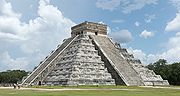
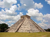
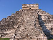 Dominating the main platform of Chichén is the Temple of Kukulkan
(the Maya name for Quetzalcoatl
), often referred to as "El Castillo" (the castle). This step pyramid
, slightly more than 29 meters high, consists of a series of square terraces, each slightly more than 2.5 meters high, with a 6-meter-high temple at the top. The sides of the pyramid are approximately 55.3 meters at the base and rise at an angle of 53 degrees, although that varies slightly for each side. The four faces of the pyramid have protruding stairways that rise at a 45-degree angle. At the base of the balustrades of the northern staircase are carved heads of a serpent.
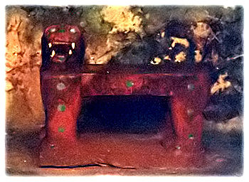
Mesoamerican cultures periodically built larger structures atop older ones, and this is one such example. In the mid 1930s, the Mexican government sponsored an excavation of El Castillo. After several false starts, they discovered a staircase under the north side of the pyramid. By digging from the top, they found another temple buried below the current one. Inside the temple chamber was a Chac Mool
statue and a throne in the shape of Jaguar, painted red and with spots made of inlaid jade. The Mexican government excavated a tunnel from the base of the north staircase, up the earlier pyramid’s stairway to the hidden temple, and opened it to tourists. In 2006, INAH closed the throne room to the public.
On the Spring and Autumn equinox, in the late afternoon, the northwest corner of the pyramid casts a series of triangular shadows against the western balustrade on the north side that evokes the appearance of a serpent wriggling down the staircase. Some have suggested the effect was an intentional design by the Maya builders to represent the feathered-serpent god Kukulcan. Archaeologists have found no evidence to support such an assertion.
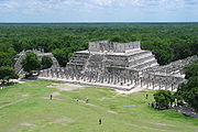
in Chichén, but the Great Ball Court about 150 metres (492.1 ft) to the north-west of the Castillo is by far the most impressive. It is the largest ball court in ancient Mesoamerica. It measures 166 by 68 m (544.6 by 223.1 ft). The imposing walls are 12 metres (39.4 ft) high, and in the center, high up on each of the long walls, are rings carved with intertwining serpents.
At the base of the high interior walls are slanted benches with sculpted panels of teams of ball players. In one panel, one of the players has been decapitated and from the wound emits seven streams of blood; six become wriggling serpents and the center becomes a winding plant.
At one end of the Great Ball Court is the North Temple, popularly called the Temple of the Bearded Man. This small masonry building has detailed bas relief carving on the inner walls, including a center figure that has carving under his chin that resembles facial hair. At the south end is another, much bigger temple, but in ruins.
Built into the east wall are the Temples of the Jaguar. The Upper Temple of the Jaguar overlooks the ball court and has an entrance guarded by two, large columns carved in the familiar feathered serpent motif. Inside there is a large mural, much destroyed, which depicts a battle scene.
In the entrance to the Lower Temple of the Jaguar, which opens behind the ball court, is another Jaguar throne, similar to the one in the inner temple of El Castillo, except that it is well worn and missing paint or other decoration. The outer columns and the walls inside the temple are covered with elaborate bas-relief carvings.
Tzompantli
is the closest to what one would find in the Mexican Plateau
. This monument, a low, flat platform, is surrounded with carved depictions of human skulls.
s consuming what appear to be human hearts.
. In its interior archaeologists discovered a collection of large cones carved out of stone, the purpose of which is unknown. This platform is placed between El Castillo and the Cenote Sagrado.
is a limestone
plain, with no rivers or streams. The region is pockmarked with natural sinkhole
s, called cenote
s, which expose the water table
to the surface. One of the most impressive of these is the Cenote Sagrado, which is 60 metres (196.9 ft) in diameter, and sheer cliffs that drop to the water table some 27 metres (88.6 ft) below.
The Cenote Sagrado was a place of pilgrimage for ancient Maya people who, according to ethnohistoric sources, would conduct sacrifices during times of drought. Archaeological investigations support this as thousands of objects have been removed from the bottom of the cenote, including material such as gold, jade
, obsidian
, shell, wood, cloth, as well as skeletons of children and men.
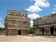
 The Temple of the Warriors complex consists of a large stepped pyramid fronted and flanked by rows of carved columns depicting warriors. This complex is analogous to Temple B at the Toltec
capital of Tula
, and indicates some form of cultural contact between the two regions. The one at Chichen Itza, however, was constructed on a larger scale. At the top of the stairway on the pyramid’s summit (and leading towards the entrance of the pyramid’s temple) is a Chac Mool
. This temple encases or entombs a former structure called The Temple of the Chac Mool. The archeological expedition and restoration of this building was done by the Carnegie Institute of Washington from 1925–1928. A key member of this restoration was Earl H. Morris who published the work from this expedition in two volumes entitled Temple of the Warriors.
To the south of the Group of a Thousand Columns is a group of three, smaller, interconnected buildings. The Temple of the Carved Columns is a small elegant building that consists of a front gallery with an inner corridor that leads to an altar with a Chac Mool. There are also numerous columns with rich, bas-relief carvings of some 40 personages. The Temple of the Small Tables which has an exterior motif of x’s and o’s. And the Palace of Ahau Balam Kauil (also known as Thompson’s Temple), a small building with two levels that has friezes depicting Jaguars (balam in Maya) as well as glyphs of the Maya god Kahuil.
 Like El Castillo, this step-pyramid temple dominates the platform, only on a smaller scale. Like its larger neighbor, it has four sides with staircases on each side. There is a temple on top, but unlike El Castillo, at the center is an opening into the pyramid which leads to a natural cave 12 metres (39.4 ft) below. Edward H. Thompson excavated this cave in the late 19th century, and because he found several skeletons and artifacts such as jade beads, he named the structure The High Priests' Temple. Archaeologists today believe neither that the structure was a tomb nor that the personages buried in it were priests.
Between the Xtoloc temple and the Ossario are several aligned structures: Platform of Venus (which is similar in design to the structure of the same name next to El Castillo), Platform of the Tombs, and a small, round structure that is unnamed. These three structures were constructed in a row extending from the Ossario. Beyond them the Ossario platform terminates in a wall, which contains an opening to a sacbe that runs several hundred feet to the Xtoloc temple.
In 2009, INAH restored a small ball court that adjoined the back wall of the Casa Colorada.
 One of the more notable structures at Chichen Itza is a complex of Terminal Classic buildings constructed in the Puuc
architectural style. The Spanish nicknamed this complex Las Monjas ("The Nuns" or "The Nunnery") but was actually a governmental palace. Just to the east is a small temple (nicknamed La Iglesia, "The Church") decorated with elaborate masks of the rain god Chaac
.
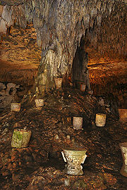 Approximately 4 km (2.5 mi) west of the Chichen Itza archaeological zone are a network of sacred caves known as Balankanche , Balamka'anche' in Modern Maya). In the caves, a large selection of ancient pottery and idols may be seen still in the positions where they were left in pre-Columbian times.
The location of the cave has been well known in modern times. Edward Thompson and Alfred Tozzer
visited it in 1905. A.S. Pearse and a team of biologists explored the cave in 1932 and 1936. E. Wyllys Andrews IV also explored the cave in the 1930s. Edwin Shook and R.E. Smith explored the cave on behalf of the Carnegie Institution
in 1954, and dug several trenches to recover potsherds and other artifacts. Shook determined that the cave had been inhabited over a long period, at least from the Preclassic to the post-conquest era.
On 15 September 1959, José Humberto Gómez, a local guide, discovered a false wall in the cave. Behind it he found an extended network of caves with significant quantities of undisturbed archaeological remains, including pottery and stone-carved censer
s, stone implements and jewelry. INAH converted the cave into an underground museum, and the objects after being catalogued were returned to their original place so visitors can see them in situ.
(with illustrations by Frederick Catherwood
). The book recounted Stephens’ visit to Yucatán and his tour of Maya cities, including Chichén Itzá. The book prompted other explorations of the city. In 1860, Desire Charnay
surveyed Chichén Itzá and took numerous photographs that he published in Cités et ruines américaines (1863).
In 1875, Augustus Le Plongeon
and his wife Alice Dixon Le Plongeon
visited Chichén, and excavated a statue of a figure on its back, knees drawn up, upper torso raised on its elbows with a plate on its stomach. Augustus Le Plongeon called it “Chaacmol” (later renamed “Chac Mool
,” which has been the term to describe all types of this statuary found in Mesoamerica). Teobert Maler and Alfred Maudslay
explored Chichén in the 1880s and both spent several weeks at the site and took extensive photographs. Maudslay published the first long-form description of Chichen Itza in his book, Biologia Centrali-Americana.
In 1894 the United States Consul to Yucatán, Edward H. Thompson
purchased the Hacienda Chichén, which included the ruins of Chichen Itza. For 30 years, Thompson explored the ancient city. His discoveries included the earliest dated carving upon a lintel in the Temple of the Initial Series and the excavation of several graves in the Ossario (High Priest’s Temple). Thompson is most famous for dredging the Cenote Sagrado (Sacred Cenote
) from 1904 to 1910, where he recovered artifacts of gold, copper and carved jade, as well as the first-ever examples of what were believed to be pre-Columbian Maya cloth and wooden weapons. Thompson shipped the bulk of the artifacts to the Peabody Museum at Harvard University
.
In 1913, the Carnegie Institution accepted the proposal of archaeologist Sylvanus G. Morley
and committed to conduct long-term archaeological research at Chichen Itza. The Mexican Revolution and the following government instability, as well as World War I, delayed the project by a decade.
In 1923, the Mexican government awarded the Carnegie Institution a 10-year permit (later extended another 10 years) to allow U.S. archaeologists to conduct extensive excavation and restoration of Chichen Itza. Carnegie researchers excavated and restored the Temple of Warriors and the Caracol, among other major buildings. At the same time, the Mexican government excavated and restored El Castillo and the Great Ball Court.
 In 1926, the Mexican government charged Edward Thompson with theft, claiming he stole the artifacts from the Cenote Sagrado and smuggled them out of the country. The government seized the Hacienda Chichén. Thompson, who was in the United States at the time, never returned to Yucatán. He wrote about his research and investigations of the Maya culture in a book People of the Serpent published in 1932. He died in New Jersey in 1935. In 1944 the Mexican Supreme Court ruled that Thompson had broken no laws and returned Chichen Itza to his heirs. The Thompsons sold the hacienda to tourism pioneer Fernando Barbachano Peon.
There have been two later expeditions to recover artifacts from the Cenote Sagrado, in 1961 and 1967. The first was sponsored by the National Geographic, and the second by private interests. Both projects were supervised by Mexico's National Institute of Anthropology and History
(INAH). INAH has conducted an ongoing effort to excavate and restore other monuments in the archaeological zone, including the Ossario, Akab D’zib, and several buildings in Chichén Viejo (Old Chichen).
In 2009, to investigate construction that predated El Castillo, Yucatec archaeologists began excavations adjacent to El Castillo under the direction of Rafael (Rach) Cobos.
, who popularized the Maya Yucatán in the public’s imagination with his book Incidents of Travel in Yucatan, inspired many to make a pilgrimage to Chichén Itzá. Even before the book was published, Benjamin Norman and Baron Emanuel von Friedrichsthal
traveled to Chichen after meeting Stephens, and both published the results of what they found. Friedrichsthal was the first to photograph Chichen Itza, using the recently invented daguerreotype
.
After Edward Thompson in 1894 purchased the Hacienda Chichén, which included Chichen Itza, he received a constant stream of visitors. In 1910 he announced his intention to construct a hotel on his property, but abandoned those plans, probably because of the Mexican Revolution.
In the early 1920s, a group of Yucatecans, led by writer/photographer Francisco Gomez Rul, began working toward expanding tourism to Yucatán. They urged Governor Felipe Carrillo Puerto to build roads to the more famous monuments, including Chichen Itza. In 1923, Governor Carrillo Puerto officially opened the highway to Chichen Itza. Gomez Rul published one of the first guidebooks to Yucatán and the ruins.
Gomez Rul's son-in-law, Fernando Barbachano Peon (a grandnephew of former Yucatán Governor Miguel Barbachano
), started Yucatán’s first official tourism business in the early 1920s. He began by meeting passengers that arrived by steamship to Progreso, the port north of Mérida, and persuading them to spend a week in Yucatán, after which they would catch the next steamship to their next destination. In his first year Barbachano Peon reportedly was only able to convince seven passengers to leave the ship and join him on a tour. In the mid-1920s Barbachano Peon persuaded Edward Thompson to sell 5 acres (20,234.3 m²) next to Chichen for a hotel. In 1930, the Mayaland Hotel opened, just north of the Hacienda Chichén, which had been taken over by the Carnegie Institution.
In 1944, Barbachano Peon purchased all of the Hacienda Chichén, including Chichen Itza, from the heirs of Edward Thompson. Around that same time the Carnegie Institution completed its work at Chichen Itza and abandoned the Hacienda Chichén, which Barbachano turned into another seasonal hotel.
In 1972, Mexico enacted the Ley Federal Sobre Monumentos y Zonas Arqueológicas, Artísticas e Históricas (Federal Law over Monuments and Archeological, Artistic and Historic Sites) that put all the nation's pre-Columbian monuments, including those at Chichen Itza, under federal ownership. There were now hundreds, if not thousands, of visitors every year to Chichen Itza, and more were expected with the development of the Cancún
resort area to the east.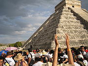 In the 1980s, Chichen Itza began to receive an influx of visitors on the day of the spring equinox. Today several thousand show up to see the light-and-shadow effect on the Temple of Kukulcan in which the feathered serpent god supposedly can be seen to crawl down the side of the pyramid. Tourists are also wondered by the acoustics at Chicen Itza. For instance a handclap in front of the staircase of the El Castillo pyramid is followed by an echo that resembles the chirp of a quetzalcoatl
as investigated by Declercq
.
Chichen Itza, a UNESCO World Heritage Site
, is the second-most visited of Mexico's archaeological sites. The archaeological site draws many visitors from the popular tourist resort of Cancún
, who make a day trip on tour buses. In 2007, Chichen Itza's El Castillo was named one of the New Seven Wonders of the World
after a worldwide vote. Despite the fact that the vote was sponsored by a commercial enterprise, and that its methodology was criticized, the vote was embraced by government and tourism officials in Mexico who project that as a result of the publicity the number of tourists expected to visit Chichen will double by 2012.
The ensuing publicity re-ignited debate in Mexico over the ownership of the site, which culminated on 29 March 2010 when the state of Yucatán purchased the land upon which the most recognized monuments rest from owner Hans Juergen Thies Barbachano.
Over the past several years, INAH, which manages the site, has been closing monuments to public access. While visitors can walk around them, they can no longer climb them or go inside their chambers. The most recent was El Castillo, which was closed after a San Diego, California, woman fell to her death in 2006.
Pre-Columbian
The pre-Columbian era incorporates all period subdivisions in the history and prehistory of the Americas before the appearance of significant European influences on the American continents, spanning the time of the original settlement in the Upper Paleolithic period to European colonization during...
archaeological site
Archaeological site
An archaeological site is a place in which evidence of past activity is preserved , and which has been, or may be, investigated using the discipline of archaeology and represents a part of the archaeological record.Beyond this, the definition and geographical extent of a 'site' can vary widely,...
built by the Maya civilization
Maya civilization
The Maya is a Mesoamerican civilization, noted for the only known fully developed written language of the pre-Columbian Americas, as well as for its art, architecture, and mathematical and astronomical systems. Initially established during the Pre-Classic period The Maya is a Mesoamerican...
located in the northern center of the Yucatán Peninsula
Yucatán Peninsula
The Yucatán Peninsula, in southeastern Mexico, separates the Caribbean Sea from the Gulf of Mexico, with the northern coastline on the Yucatán Channel...
, in the Municipality of Tinúm, Yucatán
Yucatán
Yucatán officially Estado Libre y Soberano de Yucatán is one of the 31 states which, with the Federal District, comprise the 32 Federal Entities of Mexico. It is divided in 106 municipalities and its capital city is Mérida....
state, present-day Mexico
Mexico
The United Mexican States , commonly known as Mexico , is a federal constitutional republic in North America. It is bordered on the north by the United States; on the south and west by the Pacific Ocean; on the southeast by Guatemala, Belize, and the Caribbean Sea; and on the east by the Gulf of...
.
Chichen Itza was a major focal point in the northern Maya lowlands from the Late Classic
Mesoamerican chronology
Mesoamerican chronology divides the history of pre-Columbian Mesoamerica into several periods: the Paleo-Indian , the Archaic , the Preclassic , the Classic , and the Postclassic...
through the Terminal Classic
Mesoamerican chronology
Mesoamerican chronology divides the history of pre-Columbian Mesoamerica into several periods: the Paleo-Indian , the Archaic , the Preclassic , the Classic , and the Postclassic...
and into the early portion of the Early Postclassic
Mesoamerican chronology
Mesoamerican chronology divides the history of pre-Columbian Mesoamerica into several periods: the Paleo-Indian , the Archaic , the Preclassic , the Classic , and the Postclassic...
period. The site exhibits a multitude of architectural styles, from what is called “In the Mexican Origin”, and is reminiscent of styles seen in central Mexico to the Puuc
Puuc
Puuc is the name of either a region in the Mexican state of Yucatán or a Maya architectural style prevalent in that region. The word "puuc" is derived from the Maya term for "hill". Since the Yucatán is relatively flat, this term was extended to encompass the large karstic range of hills in the...
style found among the Puuc Maya of the northern lowlands. The presence of central Mexican styles was once thought to have been representative of direct migration or even conquest from central Mexico, but most contemporary interpretations view the presence of these non-Maya styles more as the result of cultural diffusion
Cultural diffusion
In cultural anthropology and cultural geography, cultural diffusion, as first conceptualized by Alfred L. Kroeber in his influential 1940 paper Stimulus Diffusion, or trans-cultural diffusion in later reformulations, is the spread of cultural items—such as ideas, styles, religions, technologies,...
.
The ruins of Chichen Itza are federal property, and the site’s stewardship is maintained by Mexico’s Instituto Nacional de Antropología e Historia (National Institute of Anthropology and History, INAH). The land under the monuments had been privately-owned until 29 March 2010, when it was purchased by the state of Yucatán.
Name and orthography
The name is often represented as Chichén Itzá in Spanish and when translated into other languages from Spanish to show that both parts of the name are stressed on their final syllables. Other references prefer to employ a more rigorous orthography
Orthography
The orthography of a language specifies a standardized way of using a specific writing system to write the language. Where more than one writing system is used for a language, for example Kurdish, Uyghur, Serbian or Inuktitut, there can be more than one orthography...
in which the word is written according to the Maya language, using Chich'en Itzá . This form preserves the phonemic
Phoneme
In a language or dialect, a phoneme is the smallest segmental unit of sound employed to form meaningful contrasts between utterances....
distinction between ch' and ch, since the base word ch'e'en (which, however, does have a neutral tone vowel "e" in Maya and is not accented or stressed in Maya) begins with a glottalized affricate
Postalveolar ejective affricate
The palato-alveolar ejective affricate is a type of consonantal sound, used in some spoken languages. The sound is represented in the International Phonetic Alphabet with ⟨⟩. In some languages it is equivalent to a palatal ejective.-Features:...
. The word "Itzá'" has a high rise final "a" that is followed by a glottal stop
Glottal stop
The glottal stop, or more fully, the voiceless glottal plosive, is a type of consonantal sound used in many spoken languages. In English, the feature is represented, for example, by the hyphen in uh-oh! and by the apostrophe or [[ʻokina]] in Hawaii among those using a preservative pronunciation of...
(indicated by the apostrophe).
There is evidence in the Chilam Balam
Chilam Balam
The so-called Books of Chilam Balam are handwritten, chiefly 18th-century Mayan miscellanies, named after the small Yucatec towns where they were originally kept, and preserving important traditional knowledge in which indigenous Mayan and early Spanish traditions have coalesced...
books that there was another, earlier name for this city prior to the arrival of the Itza hegemony in northern Yucatán. This name is difficult to define because of the absence of a single standard of orthography, but it is represented variously as Uuc Yabnal, Uuc Hab Nal, or Uc Abnal. While most sources agree the first word means seven, there is considerable debate as to the correct translation of the rest. Among the translations suggested are “Seven Bushes,” “Seven Great Houses,” or “Seven Lines of Abnal.”
History
Cenote
A cenote is a deep natural pit, or sinkhole, characteristic of Mexico and Central America, resulting from the collapse of limestone bedrock that exposes groundwater underneath...
s, that could have provided plentiful water year round at Chichen, making it attractive for settlement. Of the two cenotes, the "Cenote Sagrado" or Sacred Cenote
Sacred Cenote
The Sacred Cenote refers to a noted cenote at the pre-Columbian Maya archaeological site of Chichen Itza, in the northern Yucatán Peninsula...
(also variously known as the Sacred Well or Well of Sacrifice), is the most famous. According to post-Conquest sources (Maya and Spanish), pre-Columbian Maya sacrificed objects and human beings into the cenote as a form of worship to the Maya rain god Chaac
Chaac
Chaac is the name of the Maya rain deity. With his lightning axe, Chaac strikes the clouds and produces thunder and rain. Chaac corresponds to Tlaloc among the Aztecs.-Rain deities and rain makers:...
. Edward Herbert Thompson
Edward Herbert Thompson
Edward Herbert Thompson was an American-born archaeologist and diplomat.-Biography:Edward H. Thompson was born in Worcester, Massachusetts. Initially inspired by the books of John Lloyd Stephens, Thompson devoted much of his career to study of the Maya civilization...
dredged the Cenote Sagrado from 1904 to 1910, and recovered artifacts of gold, jade
Jade use in Mesoamerica
Jade use in Mesoamerica was largely influenced by the conceptualization of the material as a rare and valued commodity among pre-Columbian Mesoamerican cultures, such as the Olmec, the Maya, and the various groups in the Valley of Mexico. The only source from which the indigenous cultures could...
, pottery
Pottery
Pottery is the material from which the potteryware is made, of which major types include earthenware, stoneware and porcelain. The place where such wares are made is also called a pottery . Pottery also refers to the art or craft of the potter or the manufacture of pottery...
, and incense
Incense
Incense is composed of aromatic biotic materials, which release fragrant smoke when burned. The term "incense" refers to the substance itself, rather than to the odor that it produces. It is used in religious ceremonies, ritual purification, aromatherapy, meditation, for creating a mood, and for...
, as well as human remains. A study of human remains taken from the Cenote Sagrado found that they had wounds consistent with human sacrifice.
Ascendancy
Chichen Itza rose to regional prominence towards the end of the Early ClassicMesoamerican chronology
Mesoamerican chronology divides the history of pre-Columbian Mesoamerica into several periods: the Paleo-Indian , the Archaic , the Preclassic , the Classic , and the Postclassic...
period (roughly 600 AD). It was, however, towards the end of the Late Classic
Mesoamerican chronology
Mesoamerican chronology divides the history of pre-Columbian Mesoamerica into several periods: the Paleo-Indian , the Archaic , the Preclassic , the Classic , and the Postclassic...
and into the early part of the Terminal Classic
Mesoamerican chronology
Mesoamerican chronology divides the history of pre-Columbian Mesoamerica into several periods: the Paleo-Indian , the Archaic , the Preclassic , the Classic , and the Postclassic...
that the site became a major regional capital, centralizing and dominating political, sociocultural, economic, and ideological life in the northern Maya lowlands. The ascension of Chichen Itza roughly correlates with the decline and fragmentation of the major centers of the southern Maya lowlands.
Some ethnohistoric
Ethnohistory
Ethnohistory is the study of ethnographic cultures and indigenous customs by examining historical records. It is also the study of the history of various ethnic groups that may or may not exist today....
sources claim that in about 987 a Toltec
Toltec
The Toltec culture is an archaeological Mesoamerican culture that dominated a state centered in Tula, Hidalgo in the early post-classic period of Mesoamerican chronology...
king named Topiltzin Ce Acatl Quetzalcoatl arrived here with an army from central Mexico, and (with local Maya allies) made Chichen Itza his capital, and a second Tula
Tula, Hidalgo
Tula, formally, Tula de Allende, is a town and one of the 84 municipalities of Hidalgo, in central-eastern Mexico. The municipality covers an area of 305.8 km² , and as of 2005, the municipality had a total population of 93,296, with 28,432 in the town...
. The art and architecture from this period shows an interesting mix of Maya and Toltec styles. However, the recent re-dating of Chichen Itza's decline (see below) indicates that Chichen Itza is largely a Late/Terminal Classic site, while Tula remains an Early Postclassic site (thus reversing the direction of possible influence).
Political organization
Elite
Elite refers to an exceptional or privileged group that wields considerable power within its sphere of influence...
ruling lineages. This theory was popular in the 1990s, but in recent years, the research that supported the concept of the "multepal" system has been called into question, if not discredited. The current belief trend in Maya scholarship is toward the more traditional model of the Maya kingdoms of the Classic southern lowlands.
Economy
Chichen Itza was a major economic power in the northern Maya lowlands during its apogee. Participating in the water-borne circum-peninsular trade route through its port site of Isla Cerritos, Chichen Itza was able to obtain locally unavailable resources from distant areas such as central Mexico (obsidianObsidian
Obsidian is a naturally occurring volcanic glass formed as an extrusive igneous rock.It is produced when felsic lava extruded from a volcano cools rapidly with minimum crystal growth...
) and southern Central America (gold).
Decline
According to Maya chronicles (e.g., the Book of Chilam BalamChilam Balam
The so-called Books of Chilam Balam are handwritten, chiefly 18th-century Mayan miscellanies, named after the small Yucatec towns where they were originally kept, and preserving important traditional knowledge in which indigenous Mayan and early Spanish traditions have coalesced...
of Chumayel), Hunac Ceel, ruler of Mayapan
Mayapan
Mayapan , is a Pre-Columbian Maya site a couple of kilometers south of the town of Telchaquillo in Municipality of Tecoh, approximately 40 km south-east of Mérida and 100 km west of Chichen Itza; in the state of Yucatán, Mexico...
, conquered Chichen Itza in the 13th century. Hunac Ceel supposedly prophesied his own rise to power. According to custom at the time, individuals thrown into the Cenote Sagrado were believed to have the power of prophecy if they survived. During one such ceremony, the chronicles state, there were no survivors, so Hunac Ceel leaped into the Cenote Sagrado, and when removed, prophesied his own ascension.
While there is some archaeological evidence that indicates Chichén Itzá was at one time looted and sacked, there appears to be greater evidence that it could not have been by Mayapan, at least not when Chichén Itzá was an active urban center. Archaeological data now indicates that Chichen Itza fell by around AD 1000, some two centuries before the rise of Mayapan. Ongoing research at the site of Mayapan may help resolve this chronological conundrum.
While Chichén Itzá “collapsed” (meaning elite activities ceased) it may not have been abandoned. When the Spanish arrived, they found a thriving local population, although it is not clear from Spanish sources if Maya were living in Chichen Itza or nearby. The relatively high density of population in the region was one of the factors behind the conquistadors' decision to locate a capital there (See "Spanish Arrival" below). According to post-Conquest sources, both Spanish and Maya, the Cenote Sagrado remained a place of pilgrimage.
Spanish arrival
In 1526 Spanish ConquistadorConquistador
Conquistadors were Spanish soldiers, explorers, and adventurers who brought much of the Americas under the control of Spain in the 15th to 16th centuries, following Europe's discovery of the New World by Christopher Columbus in 1492...
Francisco de Montejo
Francisco de Montejo
Francisco de Montejo y Alvarez was a Spanish conquistador in Mexico and Central America.Francisco de Montejo was born in Salamanca, Spain, in 1479 to Juan de Montejo and Catalina Alvarez de Tejeda. He left Spain in 1514, and arrived in Cuba in time to join Grijalva's expedition along the coast of...
(a veteran of the Grijalva and Cortés expeditions) successfully petitioned the King of Spain for a charter to conquer Yucatán. His first campaign in 1527, which covered much of the Yucatán peninsula, decimated his forces but ended with the establishment of a small fort at Xaman Ha'
Playa del Carmen
Playa del Carmen is a balneario resort city just south of Cancún on the coast of the Caribbean Sea, in the northeast of the Mexican state of Quintana Roo. The city is the seat of the Solidaridad municipality. In the 2010 census, the city had a population of 149,923 people and it is rapidly growing...
, south of what is today Cancún
Cancún
Cancún is a city of international tourism development certified by the UNWTO . Located on the northeast coast of Quintana Roo in southern Mexico, more than 1,700 km from Mexico City, the Project began operations in 1974 as Integrally Planned Center, a pioneer of FONATUR Cancún is a city of...
. Montejo returned to Yucatán in 1531 with reinforcements and established his main base at Campeche
Campeche
Campeche is one of the 31 states which, with the Federal District, comprise the 32 Federal Entities of Mexico. Located in Southeast Mexico, it is bordered by the states of Yucatán to the north east, Quintana Roo to the east, and Tabasco to the south west...
on the west coast. He sent his son, Francisco Montejo The Younger, in late 1532 to conquer the interior of the Yucatán Peninsula from the north. The objective from the beginning was to go to Chichén Itzá and establish a capital.
Montejo the Younger eventually arrived at Chichen Itza, which he renamed Ciudad Real. At first he encountered no resistance, and set about dividing the lands around the city and awarding them to his soldiers. The Maya became more hostile over time, and eventually they laid siege to the Spanish, cutting off their supply line to the coast, and forcing them to barricade themselves among the ruins of ancient city. Months passed, but no reinforcements arrived. Montejo the Younger attempted an all out assault against the Maya and lost 150 of his remaining forces. He was forced to abandon Chichén Itzá in 1534 under cover of darkness. By 1535, all Spanish had been driven from the Yucatán Peninsula.
Montejo eventually returned to Yucatán and, by recruiting Maya from Campeche and Champoton, built a large Indio-Spanish
Indian auxiliaries
Auxiliary Indians or indios auxiliares is the term used in old Spanish chronicles and historical texts for the indigenous peoples who were integrated into the armies of the Spanish conquerors with the purpose of supporting their advance and combat operations during the Conquest of America...
army and conquered the peninsula. The Spanish crown later issued a land grant that included Chichen Itza and by 1588 it was a working cattle ranch.
Site description
The site contains many fine stone buildings in various states of preservation, and many have been restored. The buildings are connected by a dense network of formerly paved roads, called sacbeSacbe
right|thumb|Sacbe at Dzibilchaltun in the Yucatánthumb|right|Arch at the end of the sacbé, Kabah, YucatánSacbe, plural Sacbeob, or "white ways" are raised paved roads built by the Maya civilization of pre-Columbian Mesoamerica...
ob. Archaeologists have found almost 100 sacbeob criss-crossing the site, and extending in all directions from the city.
The buildings of Chichén Itza are grouped in a series of architectonic sets, and each set was at one time separated from the other by a series of low walls. The three best known of these complexes are the Great North Platform, which includes the monuments of El Castillo, Temple of Warriors and the Great Ball Court; The Ossario Group, which includes the pyramid of the same name as well as the Temple of Xtoloc; and the Central Group, which includes the Caracol, Las Monjas, and Akab Dzib.
South of Las Monjas, in an area known as Chichén Viejo (Old Chichén) and only open to archaeologists, are several other complexes, such as the Group of the Initial Series, Group of the Lintels, and Group of the Old Castle.
El Castillo
Kukulkan
Kukulkan is the name of a Maya snake deity that also serves to designate historical persons. The depiction of the feathered serpent deity is present in other cultures of Mesoamerica. Kukulkan is closely related to the god Q'uq'umatz of the K'iche' Maya and to Quetzalcoatl of the Aztecs...
(the Maya name for Quetzalcoatl
Quetzalcoatl
Quetzalcoatl is a Mesoamerican deity whose name comes from the Nahuatl language and has the meaning of "feathered serpent". The worship of a feathered serpent deity is first documented in Teotihuacan in the first century BCE or first century CE...
), often referred to as "El Castillo" (the castle). This step pyramid
Step pyramid
Step pyramids are structures which characterized several cultures throughout history, in several locations throughout the world. These pyramids typically are large and made of several layers of stone...
, slightly more than 29 meters high, consists of a series of square terraces, each slightly more than 2.5 meters high, with a 6-meter-high temple at the top. The sides of the pyramid are approximately 55.3 meters at the base and rise at an angle of 53 degrees, although that varies slightly for each side. The four faces of the pyramid have protruding stairways that rise at a 45-degree angle. At the base of the balustrades of the northern staircase are carved heads of a serpent.
Mesoamerican cultures periodically built larger structures atop older ones, and this is one such example. In the mid 1930s, the Mexican government sponsored an excavation of El Castillo. After several false starts, they discovered a staircase under the north side of the pyramid. By digging from the top, they found another temple buried below the current one. Inside the temple chamber was a Chac Mool
Chac Mool
Chac-Mool is the name given to a type of Pre-Columbian Mesoamerican stone statue.The Chac-Mool depicts a human figure in a position of reclining with the head up and turned to one side, holding a tray over the stomach...
statue and a throne in the shape of Jaguar, painted red and with spots made of inlaid jade. The Mexican government excavated a tunnel from the base of the north staircase, up the earlier pyramid’s stairway to the hidden temple, and opened it to tourists. In 2006, INAH closed the throne room to the public.
On the Spring and Autumn equinox, in the late afternoon, the northwest corner of the pyramid casts a series of triangular shadows against the western balustrade on the north side that evokes the appearance of a serpent wriggling down the staircase. Some have suggested the effect was an intentional design by the Maya builders to represent the feathered-serpent god Kukulcan. Archaeologists have found no evidence to support such an assertion.
Great Ball Court
Archaeologists have identified several courts for playing the Mesoamerican ballgameMesoamerican ballgame
The Mesoamerican ballgame or Tlatchtli in Náhuatl was a sport with ritual associations played since 1,000 B.C. by the pre-Columbian peoples of Ancient Mexico and Central America...
in Chichén, but the Great Ball Court about 150 metres (492.1 ft) to the north-west of the Castillo is by far the most impressive. It is the largest ball court in ancient Mesoamerica. It measures 166 by 68 m (544.6 by 223.1 ft). The imposing walls are 12 metres (39.4 ft) high, and in the center, high up on each of the long walls, are rings carved with intertwining serpents.
At the base of the high interior walls are slanted benches with sculpted panels of teams of ball players. In one panel, one of the players has been decapitated and from the wound emits seven streams of blood; six become wriggling serpents and the center becomes a winding plant.
At one end of the Great Ball Court is the North Temple, popularly called the Temple of the Bearded Man. This small masonry building has detailed bas relief carving on the inner walls, including a center figure that has carving under his chin that resembles facial hair. At the south end is another, much bigger temple, but in ruins.
Built into the east wall are the Temples of the Jaguar. The Upper Temple of the Jaguar overlooks the ball court and has an entrance guarded by two, large columns carved in the familiar feathered serpent motif. Inside there is a large mural, much destroyed, which depicts a battle scene.
In the entrance to the Lower Temple of the Jaguar, which opens behind the ball court, is another Jaguar throne, similar to the one in the inner temple of El Castillo, except that it is well worn and missing paint or other decoration. The outer columns and the walls inside the temple are covered with elaborate bas-relief carvings.
Tzompantli
Tzompantli
A tzompantli or skull rack is a type of wooden rack or palisade documented in several Mesoamerican civilizations, which was used for the public display of human skulls, typically those of war captives or other sacrificial victims.-Etymology:...
is the closest to what one would find in the Mexican Plateau
Mexican Plateau
The Central Mexican Plateau, also known as the Mexican Altiplano or Altiplanicie Mexicana, is a large arid-to-semiarid plateau that occupies much of northern and central Mexico...
. This monument, a low, flat platform, is surrounded with carved depictions of human skulls.
Platform of the Eagles and the Jaguars
Next to El Castillo are a series of platforms. The Platform of the Eagles and the Jaguars is built in a combination Maya and Toltec styles. Each side has a staircase to the top. Carved into the sides are panels depicting Harpy Eagles and JaguarJaguar
The jaguar is a big cat, a feline in the Panthera genus, and is the only Panthera species found in the Americas. The jaguar is the third-largest feline after the tiger and the lion, and the largest in the Western Hemisphere. The jaguar's present range extends from Southern United States and Mexico...
s consuming what appear to be human hearts.
Platform of Venus
This platform is dedicated to the planet VenusVenus
Venus is the second planet from the Sun, orbiting it every 224.7 Earth days. The planet is named after Venus, the Roman goddess of love and beauty. After the Moon, it is the brightest natural object in the night sky, reaching an apparent magnitude of −4.6, bright enough to cast shadows...
. In its interior archaeologists discovered a collection of large cones carved out of stone, the purpose of which is unknown. This platform is placed between El Castillo and the Cenote Sagrado.
Sacbe Number One
This sacbe, which leads to the Cenote Sagrado, is the largest and most elaborate at Chichen Itza. This “white road” is 270 metres (885.8 ft) long with an average width of 9 metres (29.5 ft). It begins at a low wall a few metres from the Platform of Venus. According to archaeologists there once was an extensive building with columns at the beginning of the road.Cenote Sagrado
The Yucatán PeninsulaYucatán Peninsula
The Yucatán Peninsula, in southeastern Mexico, separates the Caribbean Sea from the Gulf of Mexico, with the northern coastline on the Yucatán Channel...
is a limestone
Limestone
Limestone is a sedimentary rock composed largely of the minerals calcite and aragonite, which are different crystal forms of calcium carbonate . Many limestones are composed from skeletal fragments of marine organisms such as coral or foraminifera....
plain, with no rivers or streams. The region is pockmarked with natural sinkhole
Sinkhole
A sinkhole, also known as a sink, shake hole, swallow hole, swallet, doline or cenote, is a natural depression or hole in the Earth's surface caused by karst processes — the chemical dissolution of carbonate rocks or suffosion processes for example in sandstone...
s, called cenote
Cenote
A cenote is a deep natural pit, or sinkhole, characteristic of Mexico and Central America, resulting from the collapse of limestone bedrock that exposes groundwater underneath...
s, which expose the water table
Water table
The water table is the level at which the submarine pressure is far from atmospheric pressure. It may be conveniently visualized as the 'surface' of the subsurface materials that are saturated with groundwater in a given vicinity. However, saturated conditions may extend above the water table as...
to the surface. One of the most impressive of these is the Cenote Sagrado, which is 60 metres (196.9 ft) in diameter, and sheer cliffs that drop to the water table some 27 metres (88.6 ft) below.
The Cenote Sagrado was a place of pilgrimage for ancient Maya people who, according to ethnohistoric sources, would conduct sacrifices during times of drought. Archaeological investigations support this as thousands of objects have been removed from the bottom of the cenote, including material such as gold, jade
Jade use in Mesoamerica
Jade use in Mesoamerica was largely influenced by the conceptualization of the material as a rare and valued commodity among pre-Columbian Mesoamerican cultures, such as the Olmec, the Maya, and the various groups in the Valley of Mexico. The only source from which the indigenous cultures could...
, obsidian
Obsidian
Obsidian is a naturally occurring volcanic glass formed as an extrusive igneous rock.It is produced when felsic lava extruded from a volcano cools rapidly with minimum crystal growth...
, shell, wood, cloth, as well as skeletons of children and men.
Temple of the Tables
To the east of El Castillo is a series of buildings, the northernmost is the Temple of the Tables. Its name comes from a series of altars at the top of the structure that are supported by small carved figures of men with upraised arms, called “atlantes.”Temple of the Warriors
Toltec
The Toltec culture is an archaeological Mesoamerican culture that dominated a state centered in Tula, Hidalgo in the early post-classic period of Mesoamerican chronology...
capital of Tula
Tula, Hidalgo
Tula, formally, Tula de Allende, is a town and one of the 84 municipalities of Hidalgo, in central-eastern Mexico. The municipality covers an area of 305.8 km² , and as of 2005, the municipality had a total population of 93,296, with 28,432 in the town...
, and indicates some form of cultural contact between the two regions. The one at Chichen Itza, however, was constructed on a larger scale. At the top of the stairway on the pyramid’s summit (and leading towards the entrance of the pyramid’s temple) is a Chac Mool
Chac Mool
Chac-Mool is the name given to a type of Pre-Columbian Mesoamerican stone statue.The Chac-Mool depicts a human figure in a position of reclining with the head up and turned to one side, holding a tray over the stomach...
. This temple encases or entombs a former structure called The Temple of the Chac Mool. The archeological expedition and restoration of this building was done by the Carnegie Institute of Washington from 1925–1928. A key member of this restoration was Earl H. Morris who published the work from this expedition in two volumes entitled Temple of the Warriors.
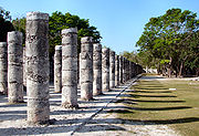
Group of a Thousand Columns
Along the south wall of the Temple of Warriors are a series of what are today exposed columns, although when the city was inhabited these would have supported an extensive roof system. The columns are in three distinct sections: an east group, that extends the lines of the front of the Temple of Warriors; a north group, which runs along the south wall of the Temple of Warriors and contains pillars with carvings of soldiers in bas-relief; and a northeast group, which apparently formed a small temple at the southeast corner of the Temple of Warriors, which contains a rectangular decorated with carvings of people or gods, as well as animals and serpents. The northeast column temple also covers a small marvel of engineering, a channel that funnels all the rainwater from the complex some 40 metres (131.2 ft) away to a rejollada, a former cenote.To the south of the Group of a Thousand Columns is a group of three, smaller, interconnected buildings. The Temple of the Carved Columns is a small elegant building that consists of a front gallery with an inner corridor that leads to an altar with a Chac Mool. There are also numerous columns with rich, bas-relief carvings of some 40 personages. The Temple of the Small Tables which has an exterior motif of x’s and o’s. And the Palace of Ahau Balam Kauil (also known as Thompson’s Temple), a small building with two levels that has friezes depicting Jaguars (balam in Maya) as well as glyphs of the Maya god Kahuil.
Steam Bath
This unique building has three parts: a waiting gallery, a water bath, and a steam chamber that operated by means of heated stones.El Mercado
This square structure anchors the southern end of the Temple of Warriors complex. It is so named for the shelf of stone that surrounds a large gallery and patio that early explorers theorized was used to display wares as in a marketplace. Today, archaeologists believe that its purpose was more ceremonial than commerce.Ossario Group
South of the North Group is a smaller platform that has many important structures, several of which appear to be oriented toward the second largest cenote at Chichen Itza, Xtoloc.Ossario
Temple of Xtoloc
Outside the Ossario Platform is this recently restored temple which overlooks the other large cenote at Chichen Itza, named after the Maya word for iguana, "Xtoloc." The temple contains a series of pilasters carved with images of people, as well as representations of plants, birds and mythological scenes.Between the Xtoloc temple and the Ossario are several aligned structures: Platform of Venus (which is similar in design to the structure of the same name next to El Castillo), Platform of the Tombs, and a small, round structure that is unnamed. These three structures were constructed in a row extending from the Ossario. Beyond them the Ossario platform terminates in a wall, which contains an opening to a sacbe that runs several hundred feet to the Xtoloc temple.
House of the Metates and House of the Mestizas
South of the Ossario, at the boundary of the platform, there are two small buildings that archaeologists believe were residences for important personages.The Casa Colorada Group
South of the Ossario Group is another small platform that has several structures that are among the oldest in the Chichen Itza archaeological zone.Casa Colorada
The Casa Colorada, which is Spanish for Red House, is one of the best preserved buildings at Chichen Itza. It also has a Maya name, Chichanchob, which according to INAH may mean "small holes." In one chamber there are extensive carved hieroglyphs that mention rulers of Chichen Itza and possibly of the nearby city of Ek Balam, and contain a Maya date inscribed which correlates to 869 a.d.e., one of the oldest such dates found in all of Chichen Itza.In 2009, INAH restored a small ball court that adjoined the back wall of the Casa Colorada.
The House of the Deer
While the Casa Colorada is in a good state of preservation, other buildings in the group, with one exception, are decrepit mounds. One building is half standing, named Casa del Venado (House of the Deer). The origin of the name is unknown, as there are no representations of deer or other animals on the building.Las Monjas
Puuc
Puuc is the name of either a region in the Mexican state of Yucatán or a Maya architectural style prevalent in that region. The word "puuc" is derived from the Maya term for "hill". Since the Yucatán is relatively flat, this term was extended to encompass the large karstic range of hills in the...
architectural style. The Spanish nicknamed this complex Las Monjas ("The Nuns" or "The Nunnery") but was actually a governmental palace. Just to the east is a small temple (nicknamed La Iglesia, "The Church") decorated with elaborate masks of the rain god Chaac
Chaac
Chaac is the name of the Maya rain deity. With his lightning axe, Chaac strikes the clouds and produces thunder and rain. Chaac corresponds to Tlaloc among the Aztecs.-Rain deities and rain makers:...
.
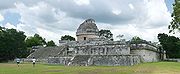
El Caracol
To the north of Las Monjas is a cockeyed, round building on a large square platform. It's nicknamed El Caracol ("the snail") because of the stone spiral staircase inside. The structure with its unusual placement on the platform and its round shape (the others are rectangular, in keeping with Maya practice), is theorized to have been a proto-observatory with doors and windows aligned to astronomical events, specifically around the path of Venus as it traverses the heavens.Akab Dzib
Located to the east of the Caracol, Akab Dzib means, in Maya, "Dark (in the "Mysterious" sense) Writing." An earlier name of the building, according to a translation of glyphs in the Casa Colorada, is Wa(k)wak Puh Ak Na, "the flat house with the excessive number of chambers,” and it was the home of the administrator of Chichén Itzá, kokom Yahawal Cho' K’ak’. INAH completed a restoration of the building in 2007. It is relatively short, only 6 metres (19.7 ft) high, and is 50 metres (164 ft) in length and 15 metres (49.2 ft) wide. The long, western-facing facade has seven doorways. The eastern facade has only four doorways, broken by a large staircase that leads to the roof. This apparently was the front of the structure, and looks out over what is today a steep, but dry, cenote. The southern end of the building has one entrance. The door opens into a small chamber and on the opposite wall is another doorway, above which on the lintel are intricately carved glyphs—the “mysterious” or “obscure” writing that gives the building its name today. Under the lintel in the door jamb is another carved panel of a seated figure surrounded by more glyphs. Inside one of the chambers, near the ceiling, is a painted hand print.Old Chichen
"Old Chichen" is the nickname for a group of structures to the south of the central site. It includes the Initial Series Group, the Phallic Temple, the Platform of the Great Turtle, the Temple of the Owls, and the Temple of the Monkeys.Other structures
Chichen Itza also has a variety of other structures densely packed in the ceremonial center of about 5 square kilometre and several outlying subsidiary sites.Caves of Balankanche
The location of the cave has been well known in modern times. Edward Thompson and Alfred Tozzer
Alfred Tozzer
Alfred Marston Tozzer was an American anthropologist, archaeologist, linguist, and educator. His principal area of interest was Mesoamerican, especially Maya, studies. He was the father of figure skating champion Joan Tozzer....
visited it in 1905. A.S. Pearse and a team of biologists explored the cave in 1932 and 1936. E. Wyllys Andrews IV also explored the cave in the 1930s. Edwin Shook and R.E. Smith explored the cave on behalf of the Carnegie Institution
Carnegie Institution for Science
The Carnegie Institution for Science is an organization in the United States established to support scientific research....
in 1954, and dug several trenches to recover potsherds and other artifacts. Shook determined that the cave had been inhabited over a long period, at least from the Preclassic to the post-conquest era.
On 15 September 1959, José Humberto Gómez, a local guide, discovered a false wall in the cave. Behind it he found an extended network of caves with significant quantities of undisturbed archaeological remains, including pottery and stone-carved censer
Censer
Censers are any type of vessels made for burning incense. These vessels vary greatly in size, form, and material of construction. They may consist of simple earthenware bowls or fire pots to intricately carved silver or gold vessels, small table top objects a few centimetres tall to as many as...
s, stone implements and jewelry. INAH converted the cave into an underground museum, and the objects after being catalogued were returned to their original place so visitors can see them in situ.
Archaeological investigations
Chichen Itza entered the popular imagination in 1843 with the book Incidents of Travel in Yucatan by John Lloyd StephensJohn Lloyd Stephens
John Lloyd Stephens was an American explorer, writer, and diplomat. Stephens was a pivotal figure in the rediscovery of Maya civilization throughout Middle America and in the planning of the Panama railroad....
(with illustrations by Frederick Catherwood
Frederick Catherwood
Frederick Catherwood was an English artist and architect, best remembered for his meticulously detailed drawings of the ruins of the Maya civilization. He explored Mesoamerica in the mid 19th century with writer John Lloyd Stephens...
). The book recounted Stephens’ visit to Yucatán and his tour of Maya cities, including Chichén Itzá. The book prompted other explorations of the city. In 1860, Desire Charnay
Désiré Charnay
Claude-Joseph Désiré Charnay was a French traveller and archaeologist notable both for his explorations of Mexico and Central America, and for the pioneering use of photography to document his discoveries....
surveyed Chichén Itzá and took numerous photographs that he published in Cités et ruines américaines (1863).
In 1875, Augustus Le Plongeon
Augustus Le Plongeon
Augustus Le Plongeon was a photographer and antiquarian who studied the pre-Columbian ruins of America, particularly those of the Maya civilization on the northern Yucatán Peninsula. While his writings contain many eccentric notions that were discredited by later researchers, Le Plongeon left a...
and his wife Alice Dixon Le Plongeon
Alice Dixon Le Plongeon
Alice Dixon Le Plongeon was an English photographer, amateur archaeologist traveller, and author. Together with her husband Augustus Le Plongeon she spent eleven years living and working in southern Mexico and Central America photographing and studying the ruined cities of the pre-Columbian Maya...
visited Chichén, and excavated a statue of a figure on its back, knees drawn up, upper torso raised on its elbows with a plate on its stomach. Augustus Le Plongeon called it “Chaacmol” (later renamed “Chac Mool
Chac Mool
Chac-Mool is the name given to a type of Pre-Columbian Mesoamerican stone statue.The Chac-Mool depicts a human figure in a position of reclining with the head up and turned to one side, holding a tray over the stomach...
,” which has been the term to describe all types of this statuary found in Mesoamerica). Teobert Maler and Alfred Maudslay
Alfred Maudslay
Alfred Percival Maudslay was a British colonial diplomat, explorer and archaeologist. He was one of the first Europeans to study Mayan ruins....
explored Chichén in the 1880s and both spent several weeks at the site and took extensive photographs. Maudslay published the first long-form description of Chichen Itza in his book, Biologia Centrali-Americana.
In 1894 the United States Consul to Yucatán, Edward H. Thompson
Edward Herbert Thompson
Edward Herbert Thompson was an American-born archaeologist and diplomat.-Biography:Edward H. Thompson was born in Worcester, Massachusetts. Initially inspired by the books of John Lloyd Stephens, Thompson devoted much of his career to study of the Maya civilization...
purchased the Hacienda Chichén, which included the ruins of Chichen Itza. For 30 years, Thompson explored the ancient city. His discoveries included the earliest dated carving upon a lintel in the Temple of the Initial Series and the excavation of several graves in the Ossario (High Priest’s Temple). Thompson is most famous for dredging the Cenote Sagrado (Sacred Cenote
Sacred Cenote
The Sacred Cenote refers to a noted cenote at the pre-Columbian Maya archaeological site of Chichen Itza, in the northern Yucatán Peninsula...
) from 1904 to 1910, where he recovered artifacts of gold, copper and carved jade, as well as the first-ever examples of what were believed to be pre-Columbian Maya cloth and wooden weapons. Thompson shipped the bulk of the artifacts to the Peabody Museum at Harvard University
Peabody Museum of Archaeology and Ethnology
The Peabody Museum of Archaeology and Ethnology is a museum affiliated with Harvard University in Cambridge, Massachusetts, USA.Founded in 1866, the Peabody Museum is one of the oldest and largest museums focusing on anthropological material, and is particularly strong in New World ethnography and...
.
In 1913, the Carnegie Institution accepted the proposal of archaeologist Sylvanus G. Morley
Sylvanus Morley
Sylvanus Griswold Morley was an American archaeologist, epigrapher, and Mayanist scholar who made significant contributions toward the study of the pre-Columbian Maya civilization in the early twentieth century....
and committed to conduct long-term archaeological research at Chichen Itza. The Mexican Revolution and the following government instability, as well as World War I, delayed the project by a decade.
In 1923, the Mexican government awarded the Carnegie Institution a 10-year permit (later extended another 10 years) to allow U.S. archaeologists to conduct extensive excavation and restoration of Chichen Itza. Carnegie researchers excavated and restored the Temple of Warriors and the Caracol, among other major buildings. At the same time, the Mexican government excavated and restored El Castillo and the Great Ball Court.
There have been two later expeditions to recover artifacts from the Cenote Sagrado, in 1961 and 1967. The first was sponsored by the National Geographic, and the second by private interests. Both projects were supervised by Mexico's National Institute of Anthropology and History
National Institute of Anthropology and History
The Instituto Nacional de Antropología e Historia is a Mexican federal government bureau established in 1939 to guarantee the research, preservation, protection, and promotion of the prehistoric, archaeological, anthropological, historical, and paleontological heritage of Mexico...
(INAH). INAH has conducted an ongoing effort to excavate and restore other monuments in the archaeological zone, including the Ossario, Akab D’zib, and several buildings in Chichén Viejo (Old Chichen).
In 2009, to investigate construction that predated El Castillo, Yucatec archaeologists began excavations adjacent to El Castillo under the direction of Rafael (Rach) Cobos.
Tourism
Tourism has been a factor at Chichen Itza for more than a century. John Lloyd StephensJohn Lloyd Stephens
John Lloyd Stephens was an American explorer, writer, and diplomat. Stephens was a pivotal figure in the rediscovery of Maya civilization throughout Middle America and in the planning of the Panama railroad....
, who popularized the Maya Yucatán in the public’s imagination with his book Incidents of Travel in Yucatan, inspired many to make a pilgrimage to Chichén Itzá. Even before the book was published, Benjamin Norman and Baron Emanuel von Friedrichsthal
Emanuel von Friedrichsthal
Emanuel von Friedrichsthal was an Austrian traveler, daguerreotypist, botanist, and amateur archaeologist, who traveled through the Balkans and in Central America and documented his findings....
traveled to Chichen after meeting Stephens, and both published the results of what they found. Friedrichsthal was the first to photograph Chichen Itza, using the recently invented daguerreotype
Daguerreotype
The daguerreotype was the first commercially successful photographic process. The image is a direct positive made in the camera on a silvered copper plate....
.
After Edward Thompson in 1894 purchased the Hacienda Chichén, which included Chichen Itza, he received a constant stream of visitors. In 1910 he announced his intention to construct a hotel on his property, but abandoned those plans, probably because of the Mexican Revolution.
In the early 1920s, a group of Yucatecans, led by writer/photographer Francisco Gomez Rul, began working toward expanding tourism to Yucatán. They urged Governor Felipe Carrillo Puerto to build roads to the more famous monuments, including Chichen Itza. In 1923, Governor Carrillo Puerto officially opened the highway to Chichen Itza. Gomez Rul published one of the first guidebooks to Yucatán and the ruins.
Gomez Rul's son-in-law, Fernando Barbachano Peon (a grandnephew of former Yucatán Governor Miguel Barbachano
Miguel Barbachano
Miguel Barbachano y Tarrazo was a liberal Yucatecan politician, who was 5 times governor of Yucatán between 1841 and 1853....
), started Yucatán’s first official tourism business in the early 1920s. He began by meeting passengers that arrived by steamship to Progreso, the port north of Mérida, and persuading them to spend a week in Yucatán, after which they would catch the next steamship to their next destination. In his first year Barbachano Peon reportedly was only able to convince seven passengers to leave the ship and join him on a tour. In the mid-1920s Barbachano Peon persuaded Edward Thompson to sell 5 acres (20,234.3 m²) next to Chichen for a hotel. In 1930, the Mayaland Hotel opened, just north of the Hacienda Chichén, which had been taken over by the Carnegie Institution.
In 1944, Barbachano Peon purchased all of the Hacienda Chichén, including Chichen Itza, from the heirs of Edward Thompson. Around that same time the Carnegie Institution completed its work at Chichen Itza and abandoned the Hacienda Chichén, which Barbachano turned into another seasonal hotel.
In 1972, Mexico enacted the Ley Federal Sobre Monumentos y Zonas Arqueológicas, Artísticas e Históricas (Federal Law over Monuments and Archeological, Artistic and Historic Sites) that put all the nation's pre-Columbian monuments, including those at Chichen Itza, under federal ownership. There were now hundreds, if not thousands, of visitors every year to Chichen Itza, and more were expected with the development of the Cancún
Cancún
Cancún is a city of international tourism development certified by the UNWTO . Located on the northeast coast of Quintana Roo in southern Mexico, more than 1,700 km from Mexico City, the Project began operations in 1974 as Integrally Planned Center, a pioneer of FONATUR Cancún is a city of...
resort area to the east.
Quetzalcoatl
Quetzalcoatl is a Mesoamerican deity whose name comes from the Nahuatl language and has the meaning of "feathered serpent". The worship of a feathered serpent deity is first documented in Teotihuacan in the first century BCE or first century CE...
as investigated by Declercq
Nico F. Declercq
Nico F. Declercq is a Physicist and Mechanical Engineer. He is a Professor with the Georgia Institute of Technology in Atlanta, Ga and Georgia Tech Lorraine in France...
.
Chichen Itza, a UNESCO World Heritage Site
World Heritage Site
A UNESCO World Heritage Site is a place that is listed by the UNESCO as of special cultural or physical significance...
, is the second-most visited of Mexico's archaeological sites. The archaeological site draws many visitors from the popular tourist resort of Cancún
Cancún
Cancún is a city of international tourism development certified by the UNWTO . Located on the northeast coast of Quintana Roo in southern Mexico, more than 1,700 km from Mexico City, the Project began operations in 1974 as Integrally Planned Center, a pioneer of FONATUR Cancún is a city of...
, who make a day trip on tour buses. In 2007, Chichen Itza's El Castillo was named one of the New Seven Wonders of the World
New Seven Wonders of the World
New7Wonders of the World was an initiative started in 2001 by the Swiss corporation New7Wonders Foundation to choose Wonders of the World from a selection of 200 existing monuments. A popularity poll was led by Canadian-Swiss Bernard Weber and organized by the New7Wonders Foundation based in...
after a worldwide vote. Despite the fact that the vote was sponsored by a commercial enterprise, and that its methodology was criticized, the vote was embraced by government and tourism officials in Mexico who project that as a result of the publicity the number of tourists expected to visit Chichen will double by 2012.
The ensuing publicity re-ignited debate in Mexico over the ownership of the site, which culminated on 29 March 2010 when the state of Yucatán purchased the land upon which the most recognized monuments rest from owner Hans Juergen Thies Barbachano.
Over the past several years, INAH, which manages the site, has been closing monuments to public access. While visitors can walk around them, they can no longer climb them or go inside their chambers. The most recent was El Castillo, which was closed after a San Diego, California, woman fell to her death in 2006.
See also
Chichen Itza in popular culture
- In the Dresden Files novel Changes, the final battle of the story takes place at Chichen Itza, wherein several buildings are destroyed due to the battle
- In the PC games Civilization IVCivilization IVSid Meier's Civilization IV is a turn-based strategy, 4X computer game released in 2005 and developed by lead designer Soren Johnson under the direction of Sid Meier and Meier's studio Firaxis Games. It is the fourth installment of the Civilization series...
and Civilization VCivilization VSid Meier's Civilization V is a turn-based strategy, 4X computer game developed by Firaxis, released on Microsoft Windows in September 2010 and on Mac OS X on November 23, 2010...
, Chichen Itza is one of the Wonders of the World that may be constructed, resulting in improved defence capabilities of the city where it's built.
Further reading
- Chichen Itza was popularized by American John Lloyd StephensJohn Lloyd StephensJohn Lloyd Stephens was an American explorer, writer, and diplomat. Stephens was a pivotal figure in the rediscovery of Maya civilization throughout Middle America and in the planning of the Panama railroad....
in Incidents of Travel in Yucatan, (two volumes, 1843) - Holmes, Archæological Studies in Ancient Cities of Mexico, (Chicago, 1895)
- Spinden, Maya Art, (Cambridge, 1912)
- Coggins & Shane, "Cenote Of Sacrifice", (U. of Texas, 1984) very scarce.
External links
- Chichen Itza on Mesoweb.com
- Chichen Itza Digital Media Archive (creative commons-licensed photos, laser scans, panoramas), with particularly detailed information on El Caracol and el Castillo, using data from a National Science FoundationNational Science FoundationThe National Science Foundation is a United States government agency that supports fundamental research and education in all the non-medical fields of science and engineering. Its medical counterpart is the National Institutes of Health...
/CyArkCyArkCyArk is a 501 nonprofit organization located in Oakland, California, United States. The company's website refers to it as a "digital archive of the world’s heritage sites for preservation and education"...
research partnership - Chichen Itza archaeologists
- UNESCO page about Chichen Itza World Heritage site
- Ancient Observatories page on Chichen Itza
- Chichen Itza reconstructed in 3D
- Archaeological documentation for Chichen Itza created by non-profit group INSIGHT and funded by the National Science FoundationNational Science FoundationThe National Science Foundation is a United States government agency that supports fundamental research and education in all the non-medical fields of science and engineering. Its medical counterpart is the National Institutes of Health...
and Chabot Space and Science CenterChabot Space and Science CenterChabot Space and Science Center, located in Oakland, California, is a hands-on center featuring interactive exhibits, a digital planetarium, a large screen theater, hands-on activities and three powerful telescopes....