

Chesterfield Canal
Encyclopedia
The Chesterfield Canal
is in the north of England
and it is known locally as 'Cuckoo Dyke'. It was opened in 1777 and ran 46 miles (74 km) from the River Trent
at West Stockwith
, Nottinghamshire
to Chesterfield
, Derbyshire
. It is currently only navigable as far as Kiveton Park
near Rotherham
, South Yorkshire
, plus an isolated section near Chesterfield.
The canal was built to export coal
, limestone
, and lead
from Derbyshire
, iron from Chesterfield, and corn, deals, timber, groceries, etc. into Derbyshire. The stone for the Palace of Westminster
was quarried in South Anston, Rotherham, and transported via the canal.
and John Varley, who estimated the cost at £94,908 17s
. Brindley presented his proposals to a meeting in Worksop on 24 August 1769. The investors asked John Grundy to carry out a second survey. He proposed a rather shorter course, from Stockwith in a straight line to Bawtry and then by Scrooby, Blyth and Carlton, to join Brindley's line at Shire Oaks. Grundy's line was 5½ miles (9 km) shorter, and the cost estimated at £71,479, 6s
. 9½d
. Although Grundy's line was considerably cheaper, it achieved this by missing Worksop
and Retford
, and the investors decided in favour of Brindley's route.
An application was made to Parliament and the Act of Parliament
received the Royal Assent
on 28 March 1771, entitled An Act for making a navigable Cut or Canal from Chesterfield, in the county of Derby, through or near Worksop and Retford, to join the River Trent, at or near Stockwith, in the county of Nottingham.
The promoters consisted of one hundred and seventy-four persons, amongst whom were the Duke of Devonshire
, the Duke of Newcastle
, Lord Scarsdale
, the Dean of York, and Sir Cecil Wray. They were incorporated by the name of The Company of Proprietors of the Canal Navigation from Chesterfield to the River Trent, and empowered to raise among themselves the sum of £100,000, in one thousand shares of £100 each, to fund the construction.
Immediately on the passing of the act, construction began under the direction of Brindley. Upon his death in September 1772, John Varley moved from Clerk of Works to resident engineer with Hugh Henshall
, Brindley's brother-in-law. Concerns were raised about John Varley's accounting and collusion in awarding contracts for construction to his relatives, and in 1773 Henshall was appointed Chief Engineer. The canal was to be built as a narrow canal, but in 1775, nine shareholders offered to fund the extra cost of making it a broad canal from Retford to Stockwith. Retford Corporation joined them, and each contributed £500. The additional cost exceeded £6000. The canal was opened throughout in 1777, but there is no record of wide-beamed boats ever using it.
As built, the canal was almost 46 miles (74 km) long, being 25 miles (40.2 km) from the Trent to Worksop with a rise of 95 feet (29 m). From Worksop to the entrance to Norwood Tunnel
it was 6.1 miles (9.8 km) with a further 145 feet (44.2 m) rise. From there to Chesterfield it was a further 13.9 miles (22.4 km) with a fall of 73 feet (22.3 m) followed by a rise of 40 feet (12.2 m). There were 65 locks in all, with two tunnels: a short 154 yard (140 m) tunnel near Gringley Beacon, and the major 2,880 yard long Norwood Tunnel. At the time of construction, Norwood Tunnel was the joint longest canal tunnel
in Britain, and it was sixth longest by the time it collapsed. The canal was a typical Brindley contour canal, following the contours to avoid costly cuttings and embankments, which resulted in a less than direct route in places.
The canal was initially fairly successful, with dividends being returned to the investors. However, the building of the Manchester, Sheffield and Lincolnshire Railway
line parallel to the canal (1849) left much of the navigation redundant, and the Worksop
to Chesterfield stretch ceased to serve commercial traffic in 1908, when problems with mining subsidence
necessitated the closure of Norwood Tunnel. The stretch between the tunnel and Worksop subsequently fell into ruin and became un-navigable, while parts of the isolated section from the tunnel to Chesterfield were infilled and redeveloped.
on the line of the Chesterfield Canal with its Western Portal in Norwood, Derbyshire
and its Eastern Portal in Kiveton, South Yorkshire
.
built for the Chesterfield Canal at Drakeholes, Nottinghamshire a location between the Norwood Tunnel and the River Trent
.
which terminated at the Chesterfield Canal near Staveley. This tunnel was 1.75 miles (2.8 km) long, its water level was one foot (30 cm) lower than that of the canal requiring the transshipment
of coal at the terminus. The boats used were loaded underground within the coalmine the tunnel served; these boats were 21 feet (6.4 m) long and 3.5 feet (1.1 m) wide.
 In 1961, the entire length of the canal was proposed for official abandonment
, but protests made meant that under the Transport Act 1968 it was classified as a cruiseway between the Trent and Worksop, while the rest was classified as remainder. Restoration
efforts began in the 1970s, with the Chesterfield Canal Society
formed in 1976, focussing initially on the route east from Norwood Tunnel
to Worksop, which presented relatively few physical obstacles to being restored to navigation.
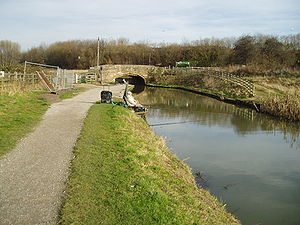
However, in practice progress was slow, and attention turned to the section west of Norwood Tunnel, where much more damage had been done to the canal bed, with it being filled in and built over in many places. However, the last five miles (8 km) of the canal, from Chesterfield to Staveley, were in good condition, and restoration began in 1987, with Tapton lock being re-opened in 1990. Derbyshire County Council acquired the section of canal between Chesterfield and Staveley and secured several large grants to begin major restoration works. Over a ten year period, four more locks and three new bridges were built, with the five-mile (8 km) section from Chesterfield being reopened to navigation in 2002, though still isolated from other waterways. A breach in the canal in early 2007 forced temporary closure of all but the top pound of the canal above Tapton Lock. The County Council are currently restoring a further section of canal at Staveley and building a new canal marina, the Staveley Town Basin which will be rewatered late 2011.
 East of Norwood, Derelict Land Grants were obtained by Rotherham and Nottinghamshire councils in 1995, and restoration between Norwood and Worksop began in earnest. In 2003, the Worksop to Norwood Tunnel stretch of the canal was reopened, with 30 restored locks, one new lock and three new bridges.
The most difficult part of the restoration project, linking the two re-opened sections, remains, with 10 miles (16 km) of canal to be restored or rebuilt, including the length of the tunnel. A significant diversion will be needed around the village of Killamarsh, where a housing estate has been built on the line of the canal. The middle section of the tunnel was lost to coal mining, and as part of the reclamation of the derelict mining area, the canal will be rebuilt in the open air, probably at a higher level with locks at each end. The eastern end of the tunnel will be retained; no firm decision has been made on the western end of the tunnel, which could be reused, or the new higher summit level extended to the west.
As a side note, in 1978 a maintenance team was dredging the bottom of the canal to remove rubbish. Later that day, they were told that a large whirlpool had formed and the canal was quickly losing water. It turned out, one of the first things removed from the canal was a large plug that had been installed to allow the canal to drain in an emergency.
along the River Rother
, to be called the Rother Link
.
This section has been affected by modern roads crossing the line with no over-bridges, and had also been lost to opencast mine working in the past. Once complete the section from the locks at Hollingwood / Staveley Works
along the valley to the north of Staveley will be reinstated, and can then be extended towards Renishaw
.
This section of the route is also part of the Trans Pennine Trail
cycle route.
The southern end of the canal in Chesterfield is being redeveloped as part of a £300 million project called Chesterfield Waterside. This will provide housing and amenities in an area which is currently derelict land. The project involves the creation of a short length of new canal to create an island in the centre of the site, navigation being restored to a length of the river, and a new basin at the southern edge of the site. Funding for the canal work is being provided by a £0.5 million grant from the East Midlands Development Agency,. The basin has been completed and was opened in October 2009, although it remains isolated from the River Rother, to which it will be connected by a lock, while a back-pumping facility will supply it with water. Outline planning permission for the whole site was granted on 15 March 2010.
Canal
Canals are man-made channels for water. There are two types of canal:#Waterways: navigable transportation canals used for carrying ships and boats shipping goods and conveying people, further subdivided into two kinds:...
is in the north of England
England
England is a country that is part of the United Kingdom. It shares land borders with Scotland to the north and Wales to the west; the Irish Sea is to the north west, the Celtic Sea to the south west, with the North Sea to the east and the English Channel to the south separating it from continental...
and it is known locally as 'Cuckoo Dyke'. It was opened in 1777 and ran 46 miles (74 km) from the River Trent
River Trent
The River Trent is one of the major rivers of England. Its source is in Staffordshire on the southern edge of Biddulph Moor. It flows through the Midlands until it joins the River Ouse at Trent Falls to form the Humber Estuary, which empties into the North Sea below Hull and Immingham.The Trent...
at West Stockwith
West Stockwith
West Stockwith is a village within the Bassetlaw district of Nottinghamshire, England.East Stockwith is a settlement close by, but within the county boundaries of Lincolnshire.-Etymology:...
, Nottinghamshire
Nottinghamshire
Nottinghamshire is a county in the East Midlands of England, bordering South Yorkshire to the north-west, Lincolnshire to the east, Leicestershire to the south, and Derbyshire to the west...
to Chesterfield
Chesterfield
Chesterfield is a market town and a borough of Derbyshire, England. It lies north of Derby, on a confluence of the rivers Rother and Hipper. Its population is 70,260 , making it Derbyshire's largest town...
, Derbyshire
Derbyshire
Derbyshire is a county in the East Midlands of England. A substantial portion of the Peak District National Park lies within Derbyshire. The northern part of Derbyshire overlaps with the Pennines, a famous chain of hills and mountains. The county contains within its boundary of approx...
. It is currently only navigable as far as Kiveton Park
Kiveton Park
Kiveton Park, informally Kiveton , is a village within the Metropolitan Borough of Rotherham, in South Yorkshire, England. Historically a part of the West Riding of Yorkshire, from the Norman conquest to 1868, Kiveton was a hamlet of the parish of Harthill-with-Woodall...
near Rotherham
Rotherham
Rotherham is a town in South Yorkshire, England. It lies on the River Don, at its confluence with the River Rother, between Sheffield and Doncaster. Rotherham, at from Sheffield City Centre, is surrounded by several smaller settlements, which together form the wider Metropolitan Borough of...
, South Yorkshire
South Yorkshire
South Yorkshire is a metropolitan county in the Yorkshire and the Humber region of England. It has a population of 1.29 million. It consists of four metropolitan boroughs: Barnsley, Doncaster, Rotherham, and City of Sheffield...
, plus an isolated section near Chesterfield.
The canal was built to export coal
Coal
Coal is a combustible black or brownish-black sedimentary rock usually occurring in rock strata in layers or veins called coal beds or coal seams. The harder forms, such as anthracite coal, can be regarded as metamorphic rock because of later exposure to elevated temperature and pressure...
, limestone
Limestone
Limestone is a sedimentary rock composed largely of the minerals calcite and aragonite, which are different crystal forms of calcium carbonate . Many limestones are composed from skeletal fragments of marine organisms such as coral or foraminifera....
, and lead
Lead
Lead is a main-group element in the carbon group with the symbol Pb and atomic number 82. Lead is a soft, malleable poor metal. It is also counted as one of the heavy metals. Metallic lead has a bluish-white color after being freshly cut, but it soon tarnishes to a dull grayish color when exposed...
from Derbyshire
Derbyshire
Derbyshire is a county in the East Midlands of England. A substantial portion of the Peak District National Park lies within Derbyshire. The northern part of Derbyshire overlaps with the Pennines, a famous chain of hills and mountains. The county contains within its boundary of approx...
, iron from Chesterfield, and corn, deals, timber, groceries, etc. into Derbyshire. The stone for the Palace of Westminster
Palace of Westminster
The Palace of Westminster, also known as the Houses of Parliament or Westminster Palace, is the meeting place of the two houses of the Parliament of the United Kingdom—the House of Lords and the House of Commons...
was quarried in South Anston, Rotherham, and transported via the canal.
Construction
The route of the canal was surveyed by James BrindleyJames Brindley
James Brindley was an English engineer. He was born in Tunstead, Derbyshire, and lived much of his life in Leek, Staffordshire, becoming one of the most notable engineers of the 18th century.-Early life:...
and John Varley, who estimated the cost at £94,908 17s
Shilling
The shilling is a unit of currency used in some current and former British Commonwealth countries. The word shilling comes from scilling, an accounting term that dates back to Anglo-Saxon times where it was deemed to be the value of a cow in Kent or a sheep elsewhere. The word is thought to derive...
. Brindley presented his proposals to a meeting in Worksop on 24 August 1769. The investors asked John Grundy to carry out a second survey. He proposed a rather shorter course, from Stockwith in a straight line to Bawtry and then by Scrooby, Blyth and Carlton, to join Brindley's line at Shire Oaks. Grundy's line was 5½ miles (9 km) shorter, and the cost estimated at £71,479, 6s
Shilling
The shilling is a unit of currency used in some current and former British Commonwealth countries. The word shilling comes from scilling, an accounting term that dates back to Anglo-Saxon times where it was deemed to be the value of a cow in Kent or a sheep elsewhere. The word is thought to derive...
. 9½d
Penny
A penny is a coin or a type of currency used in several English-speaking countries. It is often the smallest denomination within a currency system.-Etymology:...
. Although Grundy's line was considerably cheaper, it achieved this by missing Worksop
Worksop
Worksop is the largest town in the Bassetlaw district of Nottinghamshire, England on the River Ryton at the northern edge of Sherwood Forest. It is about east-south-east of the City of Sheffield and its population is estimated to be 39,800...
and Retford
Retford
Retford is a market town in Nottinghamshire in the East Midlands of England, located 31 miles from the city of Nottingham, and 23 miles west of Lincoln, in the district of Bassetlaw. The town is situated in a valley with the River Idle and the Chesterfield Canal running through the centre of the...
, and the investors decided in favour of Brindley's route.
An application was made to Parliament and the Act of Parliament
Act of Parliament
An Act of Parliament is a statute enacted as primary legislation by a national or sub-national parliament. In the Republic of Ireland the term Act of the Oireachtas is used, and in the United States the term Act of Congress is used.In Commonwealth countries, the term is used both in a narrow...
received the Royal Assent
Royal Assent
The granting of royal assent refers to the method by which any constitutional monarch formally approves and promulgates an act of his or her nation's parliament, thus making it a law...
on 28 March 1771, entitled An Act for making a navigable Cut or Canal from Chesterfield, in the county of Derby, through or near Worksop and Retford, to join the River Trent, at or near Stockwith, in the county of Nottingham.
The promoters consisted of one hundred and seventy-four persons, amongst whom were the Duke of Devonshire
Duke of Devonshire
Duke of Devonshire is a title in the peerage of England held by members of the Cavendish family. This branch of the Cavendish family has been one of the richest and most influential aristocratic families in England since the 16th century, and have been rivalled in political influence perhaps only...
, the Duke of Newcastle
Duke of Newcastle
Duke of Newcastle-upon-Tyne is a title which has been created three times in British history while the title of Duke of Newcastle-under-Lyne has been created once. The title was created for the first time in the Peerage of England in 1664 when William Cavendish, 1st Marquess of Newcastle-upon-Tyne...
, Lord Scarsdale
Viscount Scarsdale
Viscount Scarsdale, of Scarsdale in the County of Derby, is a title in the Peerage of the United Kingdom. It was created in 1911 for the prominent Conservative politician and former Viceroy of India George Curzon, 1st Baron Curzon of Kedleston, who was created Earl Curzon of Kedleston at the same...
, the Dean of York, and Sir Cecil Wray. They were incorporated by the name of The Company of Proprietors of the Canal Navigation from Chesterfield to the River Trent, and empowered to raise among themselves the sum of £100,000, in one thousand shares of £100 each, to fund the construction.
Immediately on the passing of the act, construction began under the direction of Brindley. Upon his death in September 1772, John Varley moved from Clerk of Works to resident engineer with Hugh Henshall
Hugh Henshall
Hugh Henshall was an English civil engineer, noted for his work on canals. He was born in North Staffordshire and was a student of the canal engineer James Brindley, who was also his brother-in-law.-Early life:...
, Brindley's brother-in-law. Concerns were raised about John Varley's accounting and collusion in awarding contracts for construction to his relatives, and in 1773 Henshall was appointed Chief Engineer. The canal was to be built as a narrow canal, but in 1775, nine shareholders offered to fund the extra cost of making it a broad canal from Retford to Stockwith. Retford Corporation joined them, and each contributed £500. The additional cost exceeded £6000. The canal was opened throughout in 1777, but there is no record of wide-beamed boats ever using it.
As built, the canal was almost 46 miles (74 km) long, being 25 miles (40.2 km) from the Trent to Worksop with a rise of 95 feet (29 m). From Worksop to the entrance to Norwood Tunnel
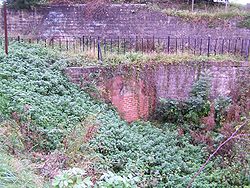
Norwood Tunnel
Norwood Tunnel was a , and brick lined canal tunnel on the line of the Chesterfield Canal with its Western Portal in Norwood, Derbyshire and its Eastern Portal in Kiveton, South Yorkshire, England.-Origins:...
it was 6.1 miles (9.8 km) with a further 145 feet (44.2 m) rise. From there to Chesterfield it was a further 13.9 miles (22.4 km) with a fall of 73 feet (22.3 m) followed by a rise of 40 feet (12.2 m). There were 65 locks in all, with two tunnels: a short 154 yard (140 m) tunnel near Gringley Beacon, and the major 2,880 yard long Norwood Tunnel. At the time of construction, Norwood Tunnel was the joint longest canal tunnel
Tunnel
A tunnel is an underground passageway, completely enclosed except for openings for egress, commonly at each end.A tunnel may be for foot or vehicular road traffic, for rail traffic, or for a canal. Some tunnels are aqueducts to supply water for consumption or for hydroelectric stations or are sewers...
in Britain, and it was sixth longest by the time it collapsed. The canal was a typical Brindley contour canal, following the contours to avoid costly cuttings and embankments, which resulted in a less than direct route in places.
The canal was initially fairly successful, with dividends being returned to the investors. However, the building of the Manchester, Sheffield and Lincolnshire Railway
Manchester, Sheffield and Lincolnshire Railway
The Manchester, Sheffield and Lincolnshire Railway was formed by amalgamation in 1847. The MS&LR changed its name to the Great Central Railway in 1897 in anticipation of the opening in 1899 of its London Extension.-Origin:...
line parallel to the canal (1849) left much of the navigation redundant, and the Worksop
Worksop
Worksop is the largest town in the Bassetlaw district of Nottinghamshire, England on the River Ryton at the northern edge of Sherwood Forest. It is about east-south-east of the City of Sheffield and its population is estimated to be 39,800...
to Chesterfield stretch ceased to serve commercial traffic in 1908, when problems with mining subsidence
Subsidence
Subsidence is the motion of a surface as it shifts downward relative to a datum such as sea-level. The opposite of subsidence is uplift, which results in an increase in elevation...
necessitated the closure of Norwood Tunnel. The stretch between the tunnel and Worksop subsequently fell into ruin and became un-navigable, while parts of the isolated section from the tunnel to Chesterfield were infilled and redeveloped.
Norwood Tunnel
Norwood Tunnel was a 2884 yards (2,637.1 m), 9.25 feet (2.8 m) and 12 feet (3.7 m), brick-lined (3 million of them) canal tunnelCanal tunnel
A canal tunnel is a tunnel for a canal. The biggest canal tunnel in the world is the Rove Tunnel in France. The oldest canal tunnel in the world is the Malpas Tunnel also in France, built in 1679. In the United States there is the Paw Paw Tunnel that opened in 1850.In some canal tunnels the towpath...
on the line of the Chesterfield Canal with its Western Portal in Norwood, Derbyshire
Derbyshire
Derbyshire is a county in the East Midlands of England. A substantial portion of the Peak District National Park lies within Derbyshire. The northern part of Derbyshire overlaps with the Pennines, a famous chain of hills and mountains. The county contains within its boundary of approx...
and its Eastern Portal in Kiveton, South Yorkshire
South Yorkshire
South Yorkshire is a metropolitan county in the Yorkshire and the Humber region of England. It has a population of 1.29 million. It consists of four metropolitan boroughs: Barnsley, Doncaster, Rotherham, and City of Sheffield...
.
Drakeholes Tunnel
Drakeholes Tunnel is a second, shorter tunnel 154 yards long also without a towpathTowpath
A towpath is a road or trail on the bank of a river, canal, or other inland waterway. The purpose of a towpath is to allow a land vehicle, beasts of burden, or a team of human pullers to tow a boat, often a barge...
built for the Chesterfield Canal at Drakeholes, Nottinghamshire a location between the Norwood Tunnel and the River Trent
River Trent
The River Trent is one of the major rivers of England. Its source is in Staffordshire on the southern edge of Biddulph Moor. It flows through the Midlands until it joins the River Ouse at Trent Falls to form the Humber Estuary, which empties into the North Sea below Hull and Immingham.The Trent...
.
Hollingwood Common Tunnel
Hollingwood Common Tunnel is a disused navigable coalmine aditAdit
An adit is an entrance to an underground mine which is horizontal or nearly horizontal, by which the mine can be entered, drained of water, and ventilated.-Construction:...
which terminated at the Chesterfield Canal near Staveley. This tunnel was 1.75 miles (2.8 km) long, its water level was one foot (30 cm) lower than that of the canal requiring the transshipment
Transshipment
Transshipment or Transhipment is the shipment of goods or containers to an intermediate destination, and then from there to yet another destination....
of coal at the terminus. The boats used were loaded underground within the coalmine the tunnel served; these boats were 21 feet (6.4 m) long and 3.5 feet (1.1 m) wide.
Restoration
Abandonment
The term abandonment has a multitude of uses, legal and extra-legal. This "signpost article" provides a guide to the various legal and quasi-legal uses of the word and includes links to articles that deal with each of the distinct concepts at greater length...
, but protests made meant that under the Transport Act 1968 it was classified as a cruiseway between the Trent and Worksop, while the rest was classified as remainder. Restoration
Waterway restoration
Waterway restoration is the activity of restoring a canal or river, including special features such as warehouse buildings, locks, boat lifts, and boats. In the United Kingdom, Canada and the United States, the focus of waterway restoration is on improving navigability, while in Australia the term...
efforts began in the 1970s, with the Chesterfield Canal Society
Chesterfield Canal Trust
The Chesterfield Canal Trust Limited is a waterway society and charitable company which campaigns for and undertakes various activities related to the Chesterfield Canal, which runs from Chesterfield in Derbyshire, England to the River Trent at West Stockwith....
formed in 1976, focussing initially on the route east from Norwood Tunnel
Norwood Tunnel
Norwood Tunnel was a , and brick lined canal tunnel on the line of the Chesterfield Canal with its Western Portal in Norwood, Derbyshire and its Eastern Portal in Kiveton, South Yorkshire, England.-Origins:...
to Worksop, which presented relatively few physical obstacles to being restored to navigation.
However, in practice progress was slow, and attention turned to the section west of Norwood Tunnel, where much more damage had been done to the canal bed, with it being filled in and built over in many places. However, the last five miles (8 km) of the canal, from Chesterfield to Staveley, were in good condition, and restoration began in 1987, with Tapton lock being re-opened in 1990. Derbyshire County Council acquired the section of canal between Chesterfield and Staveley and secured several large grants to begin major restoration works. Over a ten year period, four more locks and three new bridges were built, with the five-mile (8 km) section from Chesterfield being reopened to navigation in 2002, though still isolated from other waterways. A breach in the canal in early 2007 forced temporary closure of all but the top pound of the canal above Tapton Lock. The County Council are currently restoring a further section of canal at Staveley and building a new canal marina, the Staveley Town Basin which will be rewatered late 2011.
The most difficult part of the restoration project, linking the two re-opened sections, remains, with 10 miles (16 km) of canal to be restored or rebuilt, including the length of the tunnel. A significant diversion will be needed around the village of Killamarsh, where a housing estate has been built on the line of the canal. The middle section of the tunnel was lost to coal mining, and as part of the reclamation of the derelict mining area, the canal will be rebuilt in the open air, probably at a higher level with locks at each end. The eastern end of the tunnel will be retained; no firm decision has been made on the western end of the tunnel, which could be reused, or the new higher summit level extended to the west.
As a side note, in 1978 a maintenance team was dredging the bottom of the canal to remove rubbish. Later that day, they were told that a large whirlpool had formed and the canal was quickly losing water. It turned out, one of the first things removed from the canal was a large plug that had been installed to allow the canal to drain in an emergency.
New link to the north
Proposals are at early stages for a link north from Killamarsh to the Sheffield and South Yorkshire NavigationSheffield and South Yorkshire Navigation
The Sheffield and South Yorkshire Navigation is a system of navigable inland waterways in South Yorkshire and Lincolnshire, England....
along the River Rother
River Rother, South Yorkshire
The River Rother is a river in the northern midlands of England, after which the town of Rotherham and the Rother Valley parliamentary constituency are named. It rises near Clay Cross in Derbyshire, and flows through the centre of Chesterfield, where it feeds the Chesterfield Canal...
, to be called the Rother Link
Rother Link
The Rother Link is a planned English canal that would connect the Chesterfield Canal at Killamarsh, via the River Rother through to the Sheffield and South Yorkshire Navigation, thus creating a new cruising ring and encouraging boats to visit the Chesterfield Canal.-Proposals:The Rother Link was...
.
Development
As part of the works for the Staveley by-pass / Markham Vale Link road, the old line of the canal north of Staveley is being realigned and the new road is being built with the canal passing underneath in concrete channels.This section has been affected by modern roads crossing the line with no over-bridges, and had also been lost to opencast mine working in the past. Once complete the section from the locks at Hollingwood / Staveley Works
Staveley Coal and Iron Company
The Staveley Coal and Iron Company Limited was an industrial company based in Staveley, near Chesterfield, North Derbyshire. It exploited local ironstone quarried from land owned by the Duke of Devonshire on the outskirts of the village...
along the valley to the north of Staveley will be reinstated, and can then be extended towards Renishaw
Renishaw, Derbyshire
Renishaw is a village in the district of North East Derbyshire in England.Renishaw lies on the A6135 between the villages of Eckington and Barlborough. To the west of the village is a section of the Trans Pennine Trail long distance footpath which runs along a former railway line. Adjacent to this...
.
This section of the route is also part of the Trans Pennine Trail
Trans Pennine Trail
The Trans Pennine Trail is a long distance path running from coast to coast across northern England entirely on surfaced paths and using only gentle gradients ....
cycle route.
The southern end of the canal in Chesterfield is being redeveloped as part of a £300 million project called Chesterfield Waterside. This will provide housing and amenities in an area which is currently derelict land. The project involves the creation of a short length of new canal to create an island in the centre of the site, navigation being restored to a length of the river, and a new basin at the southern edge of the site. Funding for the canal work is being provided by a £0.5 million grant from the East Midlands Development Agency,. The basin has been completed and was opened in October 2009, although it remains isolated from the River Rother, to which it will be connected by a lock, while a back-pumping facility will supply it with water. Outline planning permission for the whole site was granted on 15 March 2010.
See also
- List of waterway societies in the United Kingdom
- List of canal tunnels in the United Kingdom
- List of canal locks in the United Kingdom
- Adelphi CanalAdelphi CanalThe Adelphi Canal was a small privately-owned canal in Duckmanton, near Chesterfield, England. It was used to transport goods from an ironworks to a wharf by the road. It is not connected to any other waterway; goods were forwarded by road to the Chesterfield Canal...
- Derby CanalDerby CanalThe Derby Canal ran from the Trent and Mersey Canal at Swarkestone to Derby and Little Eaton, and to the Erewash Canal at Sandiacre, Derbyshire, England. The canal gained its Act of Parliament in 1793 and was fully completed in 1796...
- Derby and Sandiacre Canal TrustDerby and Sandiacre Canal TrustThe Derby and Sandiacre Canal Trust is a waterway society, a charitable trust no. 1042227, registered November 21, 1994, and a registered company No...
- Chesterfield Canal TrustChesterfield Canal TrustThe Chesterfield Canal Trust Limited is a waterway society and charitable company which campaigns for and undertakes various activities related to the Chesterfield Canal, which runs from Chesterfield in Derbyshire, England to the River Trent at West Stockwith....