

Chelmer and Blackwater Navigation
Encyclopedia
The Chelmer and Blackwater Navigation is the canal
isation of the Rivers Chelmer
and Blackwater
in Essex, in the east of England. The navigation runs for 13.75 miles (22.1 km) from Springfield Basin in Chelmsford
to the sea lock at Heybridge Basin near Maldon
. It was opened in 1797, and remained under the control of the original company until 2003. It is now run by Essex Waterways Ltd, a wholly owned subsidiary of the Inland Waterways Association
.
to the sea lock at Heybridge Basin near Maldon
. It has 13 locks, including a flood lock, six bridges and drops 23 metres (75.4 feet) from the basin to the sea.
, who published his idea in a work entitled England's Improvements by Sea and Land. Maldon objected and the scheme came to nothing. In July 1733, John Hore
, who was involved in the Kennet
, Stroudwater, and the Avon Navigation at Bristol, proposed two schemes, one to make the river navigable, and another to create a new cut between Chelmsford and Maldon. Despite the projected extra costs for a canal, Hore favoured the canal scheme, as he believed there would be less objection from the millers along the river route. Maldon again objected on commercial grounds, and the scheme was dropped.
The next schemes were proposed in 1762, when the canal engineers John Smeaton
and Thomas Yeoman both carried out surveys for a possible route. Yeoman produced a second plan in 1765, and this was presented to Parliament. Yeoman had a high standing as a civil engineer, and the opponents to the scheme tried to engage a suitable engineer to counter the proposal, but many of the obvious choices, including James Brindley
, declined because they were too busy. Eventually, Ferdinando and William Stratford took on the task, but both caught ague and fever, from which Ferdinando died, while William was ill for a year but then recovered. An Act of Parliament
to authorise the plan was passed on 6 June 1766, with the stipulation that the work must be completed within 12 years, and that no work could start until 25 per cent of the capital had been raised. The scheme foundered because the required capital had not been subscribed.
Peter Muilman called a meeting in Chelmsford on 2 October 1772, to propose improvements to the river, but a subsequent meeting decided that a new cut would be a better solution. Muilman announced that this scheme would probably not require any locks, and advocated that he should build it once Robert Whitworth had surveyed it, but nothing came of this. Finally in 1792, with navigations in other parts of the country bringing increased prosperity to the towns they served, the people of Chelmsford decide to avoid the opposition of Maldon by bypassing it, and terminating the navigation at Heybridge, on the River Blackwater below Maldon. Under the direction of John Rennie Charles Wedge surveyed the route in 1792 and Matthew Hall surveyed it in 1793. The new route would increase the length of the navigation by about 2 miles (3.2 km), but this plan formed the basis of a Parliamentary Bill. Despite spirited opposition by Maldon, the bill became an Act of Parliament on 17 June 1793, creating The Company of the Proprietors of the Chelmer and Blackwater Navigation, with powers to raise £40,000 by the issuing of shares, and a further £20,000 if required. Work started soon afterwards, and although John Rennie was officially Chief Engineer
, the project was managed by Richard Coates, who had also assisted Rennie on the Ipswich and Stowmarket Navigation. The grave of Richard Coates stands in Springfield churchyard, while Rennie's original survey book for the canal has been preserved.
The port of Maldon now tried to mitigate their loss, and with advice from Benjamin Latrobe, produced a plan to improve the Blackwater through Maldon to its junction with the Chelmer at Beeleigh, which was submitted to Parliament in 1793. Realising that this would make the final cut to Heybridge redundant, the Navigation Company opposed the Bill, and it was defeated. Latrobe submitted a revised scheme in April 1795, which was also defeated. This marked the end of his engineering career in Britain, as he emigrated to America shortly afterwards. Work continued on the navigation, with the first section from Heybridge Basin to Little Baddow
opening in April 1796 and the navigation opening throughout on 3 June 1797. The final cost was around £50,000.
to the sea lock at Heybridge Basin. An additional stop lock protected the new cut from flooding at Beeleigh. Here, the navigation left the course of the River Chelmer, and joined that of the River Blackwater, before entering the final 2.5 miles (4 km) of cut to Heybridge Basin. The waters of the River Blackwater were diverted into the Chelmer, flowing over a weir between Beeleigh Lock and the stop gates. The navigation was constructed with only 2 foot (0.6096 m) of water, which was the lowest statutory draught for any of the English commercial waterways. The locks were constructed to take barges which were 60 by and each could carry around 25 tons. They were horse-drawn, and remained so until the 1960s, when diesel outboard motors were fitted. The only branch was a cut to Langford Mill, built privately by Mr Westcomb. It was well used until the 1870s, but was unused after 1881.
There were teething problems, with floods in 1797 creating shoals which prevented the passage of barges. These got steadily worse, until Rennie was called back in 1799 to address the problem. Rennie was again recalled in 1805, when the mill owners complained about leakage through the locks and requested damages. Further improvements were made, including the rebuilding of Heybridge sea lock by James Green
, and trade developed steadily. The first inland gasworks
in Britain was built in Chelmsford in 1819, using coal
brought up the navigation. Besides coal, bricks, stone, timber and general cargo was carried from Heybridge to Chelmsford, and the major cargo in the reverse direction was grain and flour. Local wharfs served the communities of Little Baddow, Boreham, Ulting and Heybridge. At its peak in the mid 19th century, the canal was carrying over 60,000 tons of cargo per year.
reached Maldon in 1848, but there was never a direct line between the two towns. Although trade declined, the impact of the railways was less significant than on many canals. Following the Second World War, the sea lock into Heybridge Basin was extended to 107 by, so that coasters carrying timber from the continent could enter the basin to transfer their cargo to barges. Traffic slowly declined until the last load of timber was delivered to Browns Yard (now Travis Perkins
) on Springfield Basin in 1972. Although commercial traffic ceased, the navigation continued to derive income from water abstraction and from the sale of wood from the willows which grow along the banks. The willow is used for making cricket bats, and the trees were first planted in the 1880s when one of the directors saw the need for alternative sources of income.
 The navigation is unusual in that it was not nationalised in 1948 when most of the other waterways in the UK
were, and remained under the control of the original Company of Proprietors of the Chelmer & Blackwater Navigation Ltd.
in 2003. Although British Waterways were approached, they declined to take over the navigation. After negotiations with the Administrator, the Inland Waterways Association
(IWA) signed a maintenance and operating agreement in November 2005 to take over responsibility for the running of the navigation through a wholly owned subsidiary
called Essex Waterways Ltd.
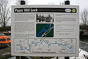
While Essex Waterways Ltd manage the navigation from day to day, it is still owned by the Company of Proprietors. The towpath from Maldon to Chelmsford has been designated as a public footpath, and is maintained in good order. Narrow boats can be hired from Paper Mill lock, and the infrastructure is being steadily upgraded. Access to the navigation from the River Blackwater is only possible at certain states of the tide, and advance booking to use the sea lock is required.
Much of the maintenance is carried out by local volunteers as well as volunteers from Waterway Recovery Group
, which is also part of the IWA. Regular working parties help to keep the waterway, including the tow path, locks and other structures well maintained, and many of the recent improvements have been undertaken by the volunteers.
Canal
Canals are man-made channels for water. There are two types of canal:#Waterways: navigable transportation canals used for carrying ships and boats shipping goods and conveying people, further subdivided into two kinds:...
isation of the Rivers Chelmer
River Chelmer
The River Chelmer is a river that flows entirely through the county of Essex, England.The source of the river is near Debden Green, a village near Thaxted. The source of the River Can is also nearby. The River Chelmer flows past Thaxted, south through the district of Uttlesford around the...
and Blackwater
River Blackwater, Essex
The River Blackwater is a river in England. It rises in the northwest of Essex as the River Pant and flows to Bocking, near Braintree, from where its name changes to the Blackwater. Its course takes it near Stisted, and then via Bradwell Juxta Coggeshall and Coggeshall and near Witham where it is...
in Essex, in the east of England. The navigation runs for 13.75 miles (22.1 km) from Springfield Basin in Chelmsford
Chelmsford
Chelmsford is the county town of Essex, England and the principal settlement of the borough of Chelmsford. It is located in the London commuter belt, approximately northeast of Charing Cross, London, and approximately the same distance from the once provincial Roman capital at Colchester...
to the sea lock at Heybridge Basin near Maldon
Maldon, Essex
Maldon is a town on the Blackwater estuary in Essex, England. It is the seat of the Maldon district and starting point of the Chelmer and Blackwater Navigation.Maldon is twinned with the Dutch town of Cuijk...
. It was opened in 1797, and remained under the control of the original company until 2003. It is now run by Essex Waterways Ltd, a wholly owned subsidiary of the Inland Waterways Association
Inland Waterways Association
The Inland Waterways Association was formed in 1946 as a registered charity in the United Kingdom to campaign for the conservation, use, maintenance, restoration and sensitive development of British Canals and river navigations....
.
Geographical Information
The navigation runs from Springfield Basin in ChelmsfordChelmsford
Chelmsford is the county town of Essex, England and the principal settlement of the borough of Chelmsford. It is located in the London commuter belt, approximately northeast of Charing Cross, London, and approximately the same distance from the once provincial Roman capital at Colchester...
to the sea lock at Heybridge Basin near Maldon
Maldon, Essex
Maldon is a town on the Blackwater estuary in Essex, England. It is the seat of the Maldon district and starting point of the Chelmer and Blackwater Navigation.Maldon is twinned with the Dutch town of Cuijk...
. It has 13 locks, including a flood lock, six bridges and drops 23 metres (75.4 feet) from the basin to the sea.
History
Prior to the actual construction of the navigation, there had been almost 120 years of proposals for such a scheme, and opposition from the port of Maldon, which anticipated that its revenues would fall if vessels could travel to Chelmsford. The first such scheme was proposed in 1677 by Andrew YarrantonAndrew Yarranton
Andrew Yarranton was an important English engineer in the 17th century who was responsible for making several rivers into navigable waterways.-Biography:...
, who published his idea in a work entitled England's Improvements by Sea and Land. Maldon objected and the scheme came to nothing. In July 1733, John Hore
John Hore
John Hore was an English navigation engineer notable for engineering the River Kennet navigation in 1718.Born in Newbury, Berkshire to a line of maltsters, worked alongside his father. When his father acquired part-ownership of the River Kennet, he also invested...
, who was involved in the Kennet
River Kennet
The Kennet is a river in the south of England, and a tributary of the River Thames. The lower reaches of the river are navigable to river craft and are known as the Kennet Navigation, which, together with the Avon Navigation, the Kennet and Avon Canal and the Thames, links the cities of Bristol...
, Stroudwater, and the Avon Navigation at Bristol, proposed two schemes, one to make the river navigable, and another to create a new cut between Chelmsford and Maldon. Despite the projected extra costs for a canal, Hore favoured the canal scheme, as he believed there would be less objection from the millers along the river route. Maldon again objected on commercial grounds, and the scheme was dropped.
The next schemes were proposed in 1762, when the canal engineers John Smeaton
John Smeaton
John Smeaton, FRS, was an English civil engineer responsible for the design of bridges, canals, harbours and lighthouses. He was also a capable mechanical engineer and an eminent physicist...
and Thomas Yeoman both carried out surveys for a possible route. Yeoman produced a second plan in 1765, and this was presented to Parliament. Yeoman had a high standing as a civil engineer, and the opponents to the scheme tried to engage a suitable engineer to counter the proposal, but many of the obvious choices, including James Brindley
James Brindley
James Brindley was an English engineer. He was born in Tunstead, Derbyshire, and lived much of his life in Leek, Staffordshire, becoming one of the most notable engineers of the 18th century.-Early life:...
, declined because they were too busy. Eventually, Ferdinando and William Stratford took on the task, but both caught ague and fever, from which Ferdinando died, while William was ill for a year but then recovered. An Act of Parliament
Act of Parliament
An Act of Parliament is a statute enacted as primary legislation by a national or sub-national parliament. In the Republic of Ireland the term Act of the Oireachtas is used, and in the United States the term Act of Congress is used.In Commonwealth countries, the term is used both in a narrow...
to authorise the plan was passed on 6 June 1766, with the stipulation that the work must be completed within 12 years, and that no work could start until 25 per cent of the capital had been raised. The scheme foundered because the required capital had not been subscribed.
Peter Muilman called a meeting in Chelmsford on 2 October 1772, to propose improvements to the river, but a subsequent meeting decided that a new cut would be a better solution. Muilman announced that this scheme would probably not require any locks, and advocated that he should build it once Robert Whitworth had surveyed it, but nothing came of this. Finally in 1792, with navigations in other parts of the country bringing increased prosperity to the towns they served, the people of Chelmsford decide to avoid the opposition of Maldon by bypassing it, and terminating the navigation at Heybridge, on the River Blackwater below Maldon. Under the direction of John Rennie Charles Wedge surveyed the route in 1792 and Matthew Hall surveyed it in 1793. The new route would increase the length of the navigation by about 2 miles (3.2 km), but this plan formed the basis of a Parliamentary Bill. Despite spirited opposition by Maldon, the bill became an Act of Parliament on 17 June 1793, creating The Company of the Proprietors of the Chelmer and Blackwater Navigation, with powers to raise £40,000 by the issuing of shares, and a further £20,000 if required. Work started soon afterwards, and although John Rennie was officially Chief Engineer
Chief Engineer
In marine transportation, the chief engineer is a licensed mariner in charge of the engineering department on a merchant vessel. "Chief engineer" is the official title of someone qualified to oversee the entire engine department; the qualification is colloquially called a "chief's...
, the project was managed by Richard Coates, who had also assisted Rennie on the Ipswich and Stowmarket Navigation. The grave of Richard Coates stands in Springfield churchyard, while Rennie's original survey book for the canal has been preserved.
The port of Maldon now tried to mitigate their loss, and with advice from Benjamin Latrobe, produced a plan to improve the Blackwater through Maldon to its junction with the Chelmer at Beeleigh, which was submitted to Parliament in 1793. Realising that this would make the final cut to Heybridge redundant, the Navigation Company opposed the Bill, and it was defeated. Latrobe submitted a revised scheme in April 1795, which was also defeated. This marked the end of his engineering career in Britain, as he emigrated to America shortly afterwards. Work continued on the navigation, with the first section from Heybridge Basin to Little Baddow
Little Baddow
Little Baddow is a large thriving village to the east of Chelmsford, Essex. The name Baddow comes from an Old English word meaning 'bad water', although this probably refers to the meadow area in Great Baddow as opposed to any water mass in Little Baddow...
opening in April 1796 and the navigation opening throughout on 3 June 1797. The final cost was around £50,000.
Operation
When completed, the length of the navigation was 13.8 miles (22.2 km). 12 locks lowered the level of the navigation by 75 feet (22.9 m) from Springfield Basin in ChelmsfordChelmsford
Chelmsford is the county town of Essex, England and the principal settlement of the borough of Chelmsford. It is located in the London commuter belt, approximately northeast of Charing Cross, London, and approximately the same distance from the once provincial Roman capital at Colchester...
to the sea lock at Heybridge Basin. An additional stop lock protected the new cut from flooding at Beeleigh. Here, the navigation left the course of the River Chelmer, and joined that of the River Blackwater, before entering the final 2.5 miles (4 km) of cut to Heybridge Basin. The waters of the River Blackwater were diverted into the Chelmer, flowing over a weir between Beeleigh Lock and the stop gates. The navigation was constructed with only 2 foot (0.6096 m) of water, which was the lowest statutory draught for any of the English commercial waterways. The locks were constructed to take barges which were 60 by and each could carry around 25 tons. They were horse-drawn, and remained so until the 1960s, when diesel outboard motors were fitted. The only branch was a cut to Langford Mill, built privately by Mr Westcomb. It was well used until the 1870s, but was unused after 1881.
There were teething problems, with floods in 1797 creating shoals which prevented the passage of barges. These got steadily worse, until Rennie was called back in 1799 to address the problem. Rennie was again recalled in 1805, when the mill owners complained about leakage through the locks and requested damages. Further improvements were made, including the rebuilding of Heybridge sea lock by James Green
James Green (engineer)
James Green was a noted civil engineer and canal engineer, who was particularly active in the South West of England, where he pioneered the building of tub boat canals, and inventive solutions for coping with hilly terrain, which included tub boat lifts and inclined planes...
, and trade developed steadily. The first inland gasworks
Gasworks
A gasworks or gas house is a factory for the manufacture of gas. The use of natural gas has made many redundant in the developed world, however they are often still used for storage.- Early gasworks :...
in Britain was built in Chelmsford in 1819, using coal
Coal
Coal is a combustible black or brownish-black sedimentary rock usually occurring in rock strata in layers or veins called coal beds or coal seams. The harder forms, such as anthracite coal, can be regarded as metamorphic rock because of later exposure to elevated temperature and pressure...
brought up the navigation. Besides coal, bricks, stone, timber and general cargo was carried from Heybridge to Chelmsford, and the major cargo in the reverse direction was grain and flour. Local wharfs served the communities of Little Baddow, Boreham, Ulting and Heybridge. At its peak in the mid 19th century, the canal was carrying over 60,000 tons of cargo per year.
Decline
The Eastern Counties Railway reached Chelmsford in 1843, and a branch line from WithamWitham-Maldon branch line
The Witham-Maldon branch line is a long closed railway line between Witham and Maldon in Essex, England which operated from 1848 until closure in 1966.-Infrastructure:...
reached Maldon in 1848, but there was never a direct line between the two towns. Although trade declined, the impact of the railways was less significant than on many canals. Following the Second World War, the sea lock into Heybridge Basin was extended to 107 by, so that coasters carrying timber from the continent could enter the basin to transfer their cargo to barges. Traffic slowly declined until the last load of timber was delivered to Browns Yard (now Travis Perkins
Travis Perkins
Travis Perkins plc is a British builders merchant based in Northampton. It is listed on the London Stock Exchange and is a constituent of the FTSE 250 Index.-History:...
) on Springfield Basin in 1972. Although commercial traffic ceased, the navigation continued to derive income from water abstraction and from the sale of wood from the willows which grow along the banks. The willow is used for making cricket bats, and the trees were first planted in the 1880s when one of the directors saw the need for alternative sources of income.
United Kingdom
The United Kingdom of Great Britain and Northern IrelandIn the United Kingdom and Dependencies, other languages have been officially recognised as legitimate autochthonous languages under the European Charter for Regional or Minority Languages...
were, and remained under the control of the original Company of Proprietors of the Chelmer & Blackwater Navigation Ltd.
The Leisure Era
Prior to the cessation of commercial traffic in 1972, pleasure craft were prohibited from using the locks, but leisure use of the navigation was encouraged after that date. However, the Navigation Company was unable to pay its way, and went into administrationAdministration (insolvency)
As a legal concept, administration is a procedure under the insolvency laws of a number of common law jurisdictions. It functions as a rescue mechanism for insolvent entities and allows them to carry on running their business. The process – an alternative to liquidation – is often known as going...
in 2003. Although British Waterways were approached, they declined to take over the navigation. After negotiations with the Administrator, the Inland Waterways Association
Inland Waterways Association
The Inland Waterways Association was formed in 1946 as a registered charity in the United Kingdom to campaign for the conservation, use, maintenance, restoration and sensitive development of British Canals and river navigations....
(IWA) signed a maintenance and operating agreement in November 2005 to take over responsibility for the running of the navigation through a wholly owned subsidiary
Subsidiary
A subsidiary company, subsidiary, or daughter company is a company that is completely or partly owned and wholly controlled by another company that owns more than half of the subsidiary's stock. The subsidiary can be a company, corporation, or limited liability company. In some cases it is a...
called Essex Waterways Ltd.
While Essex Waterways Ltd manage the navigation from day to day, it is still owned by the Company of Proprietors. The towpath from Maldon to Chelmsford has been designated as a public footpath, and is maintained in good order. Narrow boats can be hired from Paper Mill lock, and the infrastructure is being steadily upgraded. Access to the navigation from the River Blackwater is only possible at certain states of the tide, and advance booking to use the sea lock is required.
Much of the maintenance is carried out by local volunteers as well as volunteers from Waterway Recovery Group
Waterway Recovery Group
The Waterway Recovery Group , founded in 1970, is the national co-ordinating body for voluntary labour on the inland waterways of the United Kingdom.-Activities:...
, which is also part of the IWA. Regular working parties help to keep the waterway, including the tow path, locks and other structures well maintained, and many of the recent improvements have been undertaken by the volunteers.