

Channel Country
Encyclopedia
Outback
The Outback is the vast, remote, arid area of Australia, term colloquially can refer to any lands outside the main urban areas. The term "the outback" is generally used to refer to locations that are comparatively more remote than those areas named "the bush".-Overview:The outback is home to a...
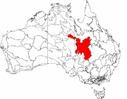
Australia located mostly in the state of Queensland
Queensland
Queensland is a state of Australia, occupying the north-eastern section of the mainland continent. It is bordered by the Northern Territory, South Australia and New South Wales to the west, south-west and south respectively. To the east, Queensland is bordered by the Coral Sea and Pacific Ocean...
but also in portions of South Australia
South Australia
South Australia is a state of Australia in the southern central part of the country. It covers some of the most arid parts of the continent; with a total land area of , it is the fourth largest of Australia's six states and two territories.South Australia shares borders with all of the mainland...
, Northern Territory
Northern Territory
The Northern Territory is a federal territory of Australia, occupying much of the centre of the mainland continent, as well as the central northern regions...
and New South Wales
New South Wales
New South Wales is a state of :Australia, located in the east of the country. It is bordered by Queensland, Victoria and South Australia to the north, south and west respectively. To the east, the state is bordered by the Tasman Sea, which forms part of the Pacific Ocean. New South Wales...
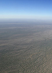
. The name comes from the numerous intertwined rivulets
Braided river
A braided river is one of a number of channel types and has a channel that consists of a network of small channels separated by small and often temporary islands called braid bars or, in British usage, aits or eyots. Braided streams occur in rivers with high slope and/or large sediment load...
that cross the region, which cover 150,000 km². The Channel Country is situated over the Cooper
Cooper Basin
The Cooper Basin is a sedimentary geological basin in Australia. The basin is located mainly in the north-east part of South Australia and extends into south-west Queensland. It is named after the Cooper Creek which is an ephemeral river that runs into Lake Eyre. Part of the Cooper Basin is...
and Eromanga
Eromanga Basin
The Eromanga Basin is a large Mesozoic sedimentary basin in central and northern Australia. It covers parts of Queensland, the Northern Territory, South Australia, and New South Wales, and is a major component of the Great Artesian Basin...
geological basins and the Lake Eyre Basin
Lake Eyre Basin
The Lake Eyre basin is a drainage basin that covers just under one-sixth of all Australia. The Lake Eyre Basin is the largest endorheic basin in Australia and amongst the largest in the world, covering about 1,200,000 square kilometres, including much of inland Queensland, large portions of South...
drainage basin. Further to the east is the less arid Maranoa
Maranoa, Queensland
The Maranoa is the name given to an area of southern Queensland. Some refer to the Maranoa as the Western Downs. The Maranoa is an eastern part of the larger, mostly arid South West region of Queensland...
district.
Birdsville
Birdsville, Queensland
-External links:*...
and Windorah
Windorah, Queensland
Windorah is one of three towns in the Barcoo in south-west Queensland, Australia. It is named after the local Aboriginal word for "Big Fish". At the 2006 census, Windorah had a population of 158....
are the most prominent towns in the area. Other settlements include Betoota
Betoota, Queensland
Betoota is a small town in Diamantina Shire, in the Channel Country of far south west Queensland, Australia which has a seasonal population; the last permanent resident, Sigmund Remienko, died in 2004. Betoota is situated on a gibber plain, 170 kilometres east of Birdsville and 227 kilometres west...
and Bedourie
Bedourie, Queensland
Bedourie is a small town located in the Channel Country of western Queensland, Australia, lying on Eyre Creek. It is located 1600 kilometres west of the state capital, Brisbane, and 200 kilometres north of Birdsville. At the 2006 census, Bedourie and the surrounding area had a population of 142...
. Haddon Corner
Haddon Corner
Haddon Corner is the north-eastern corner of the state of South Australia, where it meets with the border of Queensland. The point is located in the outback Channel Country district....
is also located in the Channel Country.
The Channel Country features an arid landscape with a series of ancient flood plains from rivers which only flow intermittently. The principal rivers are Georgina River
Georgina River
The Georgina River is the north-westernmost of the three major rivers of the Channel Country in western Queensland that flow in extremely wet years into Lake Eyre.-Geography:...
, Cooper Creek
Cooper Creek
Cooper Creek is one of the most famous and yet least visited rivers in Australia. It is sometimes known as the Barcoo River from one of its tributaries and is one of three major Queensland river systems that flow into the Lake Eyre Basin...
and the Diamantina River
Diamantina River
The Diamantina River is a river in south west Queensland and the far north of South Australia. Rising north-west of Longreach in the Swords Range, it flows in a south-westerly direction through central Queensland and the Channel Country to form the Warburton River at its confluence with the...
. When there is sufficient rainfall in their catchment area these rivers flow into Lake Eyre
Lake Eyre
Lake Eyre is the lowest point in Australia, at approximately below sea level, and, on the rare occasions that it fills, it is the largest lake in Australia and 18th largest in the world...
, South Australia
South Australia
South Australia is a state of Australia in the southern central part of the country. It covers some of the most arid parts of the continent; with a total land area of , it is the fourth largest of Australia's six states and two territories.South Australia shares borders with all of the mainland...
. In most years the flood waters are absorbed into the earth or evaporate, however. One of the most significant rainfall events occurred in 2010 when a monsoonal low from ex-Cyclone Olga created a period of exceptional rainfall.
The primary land use is cattle
Cattle
Cattle are the most common type of large domesticated ungulates. They are a prominent modern member of the subfamily Bovinae, are the most widespread species of the genus Bos, and are most commonly classified collectively as Bos primigenius...
grazing which has replaced sheep grazing. It is estimated that in the Queensland section alone there are between half to one million head of cattle. The area's towns and cattle stations are serviced by a mail run that is operated by West Wing Aviation which delivers goods and passengers as well as mail.
The Channel Country is the location for a majority of Min Min light
Min Min light
Min Min Light is the name given to an unusual light formation that has been reported numerous times in eastern Australia. The lights have been reported from as far south as Brewarrina in western New South Wales, to as far north as Boulia in northern Queensland...
sightings. It is also home to at least two important bird areas, Lake Yamma Yamma
Lake Yamma Yamma
Lake Yamma Yamma is an ephemeral lake on the Cooper Creek system in the arid Channel Country of south-western Queensland, Australia. The lake, which is sometimes called Lake Mackillop, is the largest inland ephemeral lake in Queensland.-Description:...
and the Lake Machattie Area
Lake Machattie Area
The Lake Machattie Area is a 909 km2 tract of land comprising Lakes Machattie, Mipia and Koolivoo, with the surrounding Georgina River and Eyre Creek floodplains, in the arid Channel Country of western Queensland, Australia...
.
Bioregion
The Interim Biogeographic Regionalisation for AustraliaInterim Biogeographic Regionalisation for Australia
The Interim Biogeographic Regionalisation for Australia is a biogeographic regionalisation of Australia developed by the Australian Government's Department of the Environment, Water, Heritage and the Arts...
Channel Country Bioregion covers a larger area, extending into South Australia, the Northern Territory and New South Wales and includes the town of Innamincka
Innamincka, South Australia
Innamincka is a tiny settlement in north-east South Australia. It is 1065 km northeast of Adelaide and 459 km from Lyndhurst up the Strzelecki Track. It is situated on the banks of Cooper Creek in the state's Channel Country, and surrounded by the Strzelecki, Tirari and Sturt Stony...
.