
Chandra Taal
Encyclopedia
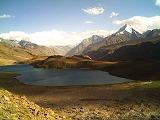
Chandra Taal or Chandra Tal, is situated at an altitude of about 4300 metres (14,107.6 ft) in the Himalayas
. Mountains of scree overlook the lake on one side, and a magnificent cirque
presents a view on the other. The name of the lake originates from its crescent shape. Situated in the Spiti part of the Lahul and Spiti
district of Himachal Pradesh
(India
), Chandra Taal is a popular destination for trekkers and campers. The lake is accessible on foot from Batal as well as from Kunzum Pass
from late May to early October. There is also a motorable road from Batal which is 14 km (8.7 mi) away from Chandra Taal, but before August, its condition can be bad. The road from Kunzum Pass is accessible only on foot, and it is about 8 km (5 mi) from Chandra Taal. Suraj Tal is also accessible Chandra Taal, 30 km (18.6 mi) away. Vast meadows on the banks of the lake are the camping sites. During springtime, these meadows are carpeted with hundreds of kinds of wildflowers.
The most surprising thing about this lake is that there is no visible source of this lake but there is a visible outlet of this lake which means that water to this lake comes from underground.
The lake is situated on the Samudra Tapu plateau, which overlooks the Chandra River.
Himalayas
The Himalaya Range or Himalaya Mountains Sanskrit: Devanagari: हिमालय, literally "abode of snow"), usually called the Himalayas or Himalaya for short, is a mountain range in Asia, separating the Indian subcontinent from the Tibetan Plateau...
. Mountains of scree overlook the lake on one side, and a magnificent cirque
Cirque (landform)
thumb|250 px|Two cirques with semi-permanent snowpatches in [[Abisko National Park]], [[Sweden]].A cirque or corrie is an amphitheatre-like valley head, formed at the head of a valley glacier by erosion...
presents a view on the other. The name of the lake originates from its crescent shape. Situated in the Spiti part of the Lahul and Spiti
Lahul and Spiti
The district of Lahaul-Spiti in the Indian state of Himachal Pradesh consists of the two formerly separate districts of Lahaul and Spiti. The present administrative centre is Keylong in Lahaul...
district of Himachal Pradesh
Himachal Pradesh
Himachal Pradesh is a state in Northern India. It is spread over , and is bordered by the Indian states of Jammu and Kashmir on the north, Punjab on the west and south-west, Haryana and Uttar Pradesh on the south, Uttarakhand on the south-east and by the Tibet Autonomous Region on the east...
(India
India
India , officially the Republic of India , is a country in South Asia. It is the seventh-largest country by geographical area, the second-most populous country with over 1.2 billion people, and the most populous democracy in the world...
), Chandra Taal is a popular destination for trekkers and campers. The lake is accessible on foot from Batal as well as from Kunzum Pass
Kunzum Pass
Kunzum Pass Kunzum Pass Kunzum Pass (Tibetan: Kunzum La, (el. ), is a high mountain pass on the eastern Kunzum Range of the Himalayas some from Manali. It connects the Kullu Valley and Lahul Valley with the Spiti Valley of Himachal Pradesh, India....
from late May to early October. There is also a motorable road from Batal which is 14 km (8.7 mi) away from Chandra Taal, but before August, its condition can be bad. The road from Kunzum Pass is accessible only on foot, and it is about 8 km (5 mi) from Chandra Taal. Suraj Tal is also accessible Chandra Taal, 30 km (18.6 mi) away. Vast meadows on the banks of the lake are the camping sites. During springtime, these meadows are carpeted with hundreds of kinds of wildflowers.
The most surprising thing about this lake is that there is no visible source of this lake but there is a visible outlet of this lake which means that water to this lake comes from underground.
The lake is situated on the Samudra Tapu plateau, which overlooks the Chandra River.