

Cetina
Encyclopedia
Cetina is a river
in southern Croatia
. It has a length of 101 km (62.8 mi) and its basin covers an area of 1463 square kilometre. Cetina descends from an altitude of 385 m at its source to the sea level when it flows into the Adriatic Sea
. It is the most water-rich river in Dalmatia.
 Cetina has its source in the northwestern slopes of Dinara
. Rising from a spring at Milasevo near a small village called Cetina
, located 7 km north from Vrlika
, it flows a distance of 105 km to the Adriatic Sea
. A large artificial lake begins near Vrlika, the Peruća Lake
, which was created by a dam some 25 km downstream. Cetina then passes into the lower portion of the Sinj
karst
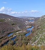
field, through the city of Sinj. After that it runs eastward, through the city of Trilj and then back westward around the Mosor
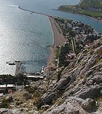
mountain, before flowing into the Adriatic in the city of Omiš
.
Apart from its visible basin, the Cetina also receives a lot of water from the west Bosnian karst field via underground routes. Its lower course begins from the Gubavica Falls (49 m a.s.l.) near the village of Zadvarje
(20 km from Omiš). Here it leaves its canyon and flows into a valley which has nevertheless retained something of the appearance of a canyon.
The latter portion of Cetina and its relatively large drop in altitude was used to build several substantial hydroelectric power plants. Its water is also bottled as Cetina.
The total drainage area of the catchment is around 12,000 km2, and the annual discharge is around 105 m2s–1 as a consequence of a mean annual rainfall of 1380 mm.
Bounded to the east by the Dinaric Alps
, which rise to an altitude of 2000 m, and to the northwest by mountain Svilaja
, the majority of the catchment drains calcareous
rocks of Cretaceous
age, predominantly limestone
. Rocks of Triassic
and Jurassic
age also crop out in the catchment and include dolomitic limestone and flysch
. The underlying karst
geology controls relief with a series of structurally aligned basin
s separated by high ridge
s.
have always functioned as a principal trade route between the Croatian coast and hinterland. Strategically, it has been pivotal to the development, not only of the Balkans, but also of significant parts of Europe.
 The earliest evidence for agricultural activity is from the Early Neolithic
in the upper part of the valley. In the Early Bronze Age
the Cetina Culture, a geographically pervasive group with contacts throughout the Adriatic basin, became dominant. Extensive mound fields are recorded on the lower valley slopes at several locations around Cetina, Vrlika
and Bajagić
. As in other parts of Europe, the river appears to have been the focus of the intentional deposition of artifacts throughout prehistory. This is particularly true at the confluence of the Cetina and Ruda
rivers at Trilj
.
The area is intimately associated with the heartland of the Delmatae and the area's strategic importance is emphasised by the citing of the legionary
fortress at Tilurium
(Gardun
), just above today's city of Trilj
, which guards the entrance to the valley from the south and the approach to the provincial capital at Salona
.
During the early medieval period, toponymic evidence suggests that the Cetina Valley and perhaps the river itself became a frontier between Slavic and Late Roman power. The area around Sinj
eventually emerged as a centre of Slavic power and ultimately established itself as a heartland of the Early Croatian State, especially in the areas of its upper flow.
During later periods the area was highly contests and passed between a number of regional and local powers before conquest by the Ottoman Empire
during the early 16th century. After this it retained a frontier role between Ottoman Empire and Republic of Venice until the reconquest of the area 150 years later.
River
A river is a natural watercourse, usually freshwater, flowing towards an ocean, a lake, a sea, or another river. In a few cases, a river simply flows into the ground or dries up completely before reaching another body of water. Small rivers may also be called by several other names, including...
in southern Croatia
Croatia
Croatia , officially the Republic of Croatia , is a unitary democratic parliamentary republic in Europe at the crossroads of the Mitteleuropa, the Balkans, and the Mediterranean. Its capital and largest city is Zagreb. The country is divided into 20 counties and the city of Zagreb. Croatia covers ...
. It has a length of 101 km (62.8 mi) and its basin covers an area of 1463 square kilometre. Cetina descends from an altitude of 385 m at its source to the sea level when it flows into the Adriatic Sea
Adriatic Sea
The Adriatic Sea is a body of water separating the Italian Peninsula from the Balkan peninsula, and the system of the Apennine Mountains from that of the Dinaric Alps and adjacent ranges...
. It is the most water-rich river in Dalmatia.
Geography and geology
Dinara
Dinara is a mountain located on the border of Croatia and Bosnia and Herzegovina. One of its summits, also called Dinara, is the highest point in Croatia at 1,831 m and a prominence of 728 m.-Etymology:...
. Rising from a spring at Milasevo near a small village called Cetina
Cetina (Civljane)
Cetina is a small village a part of Civljane municipality in Šibenik-Knin County, Croatia, with 123 inhabitants.Located in inland Dalmatia, north from the town of Vrlika, on the route between towns of Knin and Vrlika, Cetina village spread on 50.98 km2, on the field near the spring of river...
, located 7 km north from Vrlika
Vrlika
Vrlika is a small town and municipality in inland Dalmatia, Croatia. The closest large towns are Sinj, Knin, and Drniš. The town of Vrlika has a population of 959, while the municipality has a population of 2,705 . There are 2,670 Croatian speakers, 16 Serbian speakers and 19 speakers of other...
, it flows a distance of 105 km to the Adriatic Sea
Adriatic Sea
The Adriatic Sea is a body of water separating the Italian Peninsula from the Balkan peninsula, and the system of the Apennine Mountains from that of the Dinaric Alps and adjacent ranges...
. A large artificial lake begins near Vrlika, the Peruća Lake
Peruca Lake
Lake Peruća or Peruča is the second artificial lake in Croatia after Lake Dubrava. It is located in the Split-Dalmatia county.-Location:...
, which was created by a dam some 25 km downstream. Cetina then passes into the lower portion of the Sinj
Sinj
Sinj is a town in the continental part of Split-Dalmatia County, Croatia. The town itself has a population of 11,448, while the population of the administrative municipality which includes surrounding villages is 24,832 ....
karst
KARST
Kilometer-square Area Radio Synthesis Telescope is a Chinese telescope project to which FAST is a forerunner. KARST is a set of large spherical reflectors on karst landforms, which are bowlshaped limestone sinkholes named after the Kras region in Slovenia and Northern Italy. It will consist of...
field, through the city of Sinj. After that it runs eastward, through the city of Trilj and then back westward around the Mosor
Mosor
Mosor is a mountain range in Croatia located near the town of Split on the Adriatic coast. It belongs to Dinaric Alps, and it stretches from the pass of Klis in the northwest to the Cetina River in the southeast....
mountain, before flowing into the Adriatic in the city of Omiš
Omiš
Omiš is a town and port in the Dalmatia region of Croatia, and is a municipality in the Split-Dalmatia County. The town is situated approximately south-east of Croatia's second largest city, Split. Its location is where the emerald-green Cetina River meets the Adriatic Sea...
.
Apart from its visible basin, the Cetina also receives a lot of water from the west Bosnian karst field via underground routes. Its lower course begins from the Gubavica Falls (49 m a.s.l.) near the village of Zadvarje
Zadvarje
Zadvarje is a village and a municipality in the Split-Dalmatia County, Croatia. It has a population of 277 , 97% of which are Croats. The only settlement in Zadvarje municipality is Zadvarje itself....
(20 km from Omiš). Here it leaves its canyon and flows into a valley which has nevertheless retained something of the appearance of a canyon.
The latter portion of Cetina and its relatively large drop in altitude was used to build several substantial hydroelectric power plants. Its water is also bottled as Cetina.
The total drainage area of the catchment is around 12,000 km2, and the annual discharge is around 105 m2s–1 as a consequence of a mean annual rainfall of 1380 mm.
Bounded to the east by the Dinaric Alps
Dinaric Alps
The Dinaric Alps or Dinarides form a mountain chain in Southern Europe, spanning areas of Slovenia, Croatia, Bosnia and Herzegovina, Serbia, Kosovo, Albania and Montenegro....
, which rise to an altitude of 2000 m, and to the northwest by mountain Svilaja
Svilaja
Svilaja is a mountain range in Croatia, located in inland of Dalmatian Zagora.It belongs to Dinaric Alps, and it stretches from the town of Sinj northwest to the Petrovo field, approximate 30 km in length....
, the majority of the catchment drains calcareous
Calcareous
Calcareous is an adjective meaning mostly or partly composed of calcium carbonate, in other words, containing lime or being chalky. The term is used in a wide variety of scientific disciplines.-In zoology:...
rocks of Cretaceous
Cretaceous
The Cretaceous , derived from the Latin "creta" , usually abbreviated K for its German translation Kreide , is a geologic period and system from circa to million years ago. In the geologic timescale, the Cretaceous follows the Jurassic period and is followed by the Paleogene period of the...
age, predominantly limestone
Limestone
Limestone is a sedimentary rock composed largely of the minerals calcite and aragonite, which are different crystal forms of calcium carbonate . Many limestones are composed from skeletal fragments of marine organisms such as coral or foraminifera....
. Rocks of Triassic
Triassic
The Triassic is a geologic period and system that extends from about 250 to 200 Mya . As the first period of the Mesozoic Era, the Triassic follows the Permian and is followed by the Jurassic. Both the start and end of the Triassic are marked by major extinction events...
and Jurassic
Jurassic
The Jurassic is a geologic period and system that extends from about Mya to Mya, that is, from the end of the Triassic to the beginning of the Cretaceous. The Jurassic constitutes the middle period of the Mesozoic era, also known as the age of reptiles. The start of the period is marked by...
age also crop out in the catchment and include dolomitic limestone and flysch
Flysch
Flysch is a sequence of sedimentary rocks that is deposited in a deep marine facies in the foreland basin of a developing orogen. Flysch is typically deposited during an early stage of the orogenesis. When the orogen evolves the foreland basin becomes shallower and molasse is deposited on top of...
. The underlying karst
KARST
Kilometer-square Area Radio Synthesis Telescope is a Chinese telescope project to which FAST is a forerunner. KARST is a set of large spherical reflectors on karst landforms, which are bowlshaped limestone sinkholes named after the Kras region in Slovenia and Northern Italy. It will consist of...
geology controls relief with a series of structurally aligned basin
Depression (geology)
A depression in geology is a landform sunken or depressed below the surrounding area. Depressions may be formed by various mechanisms.Structural or tectonic related:...
s separated by high ridge
Ridge
A ridge is a geological feature consisting of a chain of mountains or hills that form a continuous elevated crest for some distance. Ridges are usually termed hills or mountains as well, depending on size. There are several main types of ridges:...
s.
History and archaeology
The Cetina Valley and the narrow passage at KlisKlis
Klis is a village located around a mountain fortress bearing the same name. It is located in central Dalmatia, Croatia, located just northeast of Solin and Split near the eponymous mountain pass...
have always functioned as a principal trade route between the Croatian coast and hinterland. Strategically, it has been pivotal to the development, not only of the Balkans, but also of significant parts of Europe.
Neolithic
The Neolithic Age, Era, or Period, or New Stone Age, was a period in the development of human technology, beginning about 9500 BC in some parts of the Middle East, and later in other parts of the world. It is traditionally considered as the last part of the Stone Age...
in the upper part of the valley. In the Early Bronze Age
Bronze Age
The Bronze Age is a period characterized by the use of copper and its alloy bronze as the chief hard materials in the manufacture of some implements and weapons. Chronologically, it stands between the Stone Age and Iron Age...
the Cetina Culture, a geographically pervasive group with contacts throughout the Adriatic basin, became dominant. Extensive mound fields are recorded on the lower valley slopes at several locations around Cetina, Vrlika
Vrlika
Vrlika is a small town and municipality in inland Dalmatia, Croatia. The closest large towns are Sinj, Knin, and Drniš. The town of Vrlika has a population of 959, while the municipality has a population of 2,705 . There are 2,670 Croatian speakers, 16 Serbian speakers and 19 speakers of other...
and Bajagić
Bajagić, Croatia
Bajagić is a village in Sinj municipality, Split-Dalmatia County, Croatia. Population is 565 ....
. As in other parts of Europe, the river appears to have been the focus of the intentional deposition of artifacts throughout prehistory. This is particularly true at the confluence of the Cetina and Ruda
Ruda
Ruda may refer to:* Ruda, worshipped among the North Arabian tribes of pre-Islamic Arabia* Ruda, Sweden* Ruda, Italy* Ruda, a village in Ghelari Commune, Hunedoara County, Romania* Ruda, a village in Budeşti Commune, Vâlcea County, Romania...
rivers at Trilj
Trilj
Trilj is a municipality and town in inland Dalmatia, Croatia. It is located southeast of Sinj and northeast of Split. The total population of the municipality is 9,417, with 2,110 in Trilj itself and the rest in small villages...
.
The area is intimately associated with the heartland of the Delmatae and the area's strategic importance is emphasised by the citing of the legionary
Legionary
The Roman legionary was a professional soldier of the Roman army after the Marian reforms of 107 BC. Legionaries had to be Roman citizens under the age of 45. They enlisted in a legion for twenty-five years of service, a change from the early practice of enlisting only for a campaign...
fortress at Tilurium
Tilurium
Tilurium was an Illyrian fortified settlement of the Delmatae.Tilurium was the location a Roman cohort in the territory of the Delmatae. The site is now located on the hill of Gardun near Trilj.-External links:*...
(Gardun
Gardun
Gardun is a village at the top of the hill of Gardun, just 1 km south of Trilj.In the 1997, excavations of the remains of legionary fortress of Tilurium started on the southern outskirts of the village....
), just above today's city of Trilj
Trilj
Trilj is a municipality and town in inland Dalmatia, Croatia. It is located southeast of Sinj and northeast of Split. The total population of the municipality is 9,417, with 2,110 in Trilj itself and the rest in small villages...
, which guards the entrance to the valley from the south and the approach to the provincial capital at Salona
Salona
Salona was an ancient Illyrian Delmati city in the first millennium BC. The Greeks had set up an emporion there. After the conquest by the Romans, Salona became the capital of the Roman province of Dalmatia...
.
During the early medieval period, toponymic evidence suggests that the Cetina Valley and perhaps the river itself became a frontier between Slavic and Late Roman power. The area around Sinj
Sinj
Sinj is a town in the continental part of Split-Dalmatia County, Croatia. The town itself has a population of 11,448, while the population of the administrative municipality which includes surrounding villages is 24,832 ....
eventually emerged as a centre of Slavic power and ultimately established itself as a heartland of the Early Croatian State, especially in the areas of its upper flow.
During later periods the area was highly contests and passed between a number of regional and local powers before conquest by the Ottoman Empire
Ottoman Empire
The Ottoman EmpireIt was usually referred to as the "Ottoman Empire", the "Turkish Empire", the "Ottoman Caliphate" or more commonly "Turkey" by its contemporaries...
during the early 16th century. After this it retained a frontier role between Ottoman Empire and Republic of Venice until the reconquest of the area 150 years later.
External links
- OmisInfo.com, Cetina River
- Omis-Croatia.com, Pictures of River Cetine
- River Cetina canyon picture @activeholidays-croatia.com