

Cerro Grande Fire
Encyclopedia
New Mexico
New Mexico is a state located in the southwest and western regions of the United States. New Mexico is also usually considered one of the Mountain States. With a population density of 16 per square mile, New Mexico is the sixth-most sparsely inhabited U.S...
, United States of America that occurred in May 2000. The fire started as a controlled burn
Controlled burn
Controlled or prescribed burning, also known as hazard reduction burning or Swailing is a technique sometimes used in forest management, farming, prairie restoration or greenhouse gas abatement. Fire is a natural part of both forest and grassland ecology and controlled fire can be a tool for...
, and became uncontrolled owing to high winds and drought
Drought
A drought is an extended period of months or years when a region notes a deficiency in its water supply. Generally, this occurs when a region receives consistently below average precipitation. It can have a substantial impact on the ecosystem and agriculture of the affected region...
conditions. Over 400 families in the town of Los Alamos, New Mexico
Los Alamos, New Mexico
Los Alamos is a townsite and census-designated place in Los Alamos County, New Mexico, United States, built upon four mesas of the Pajarito Plateau and the adjoining White Rock Canyon. The population of the CDP was 12,019 at the 2010 Census. The townsite or "the hill" is one part of town while...
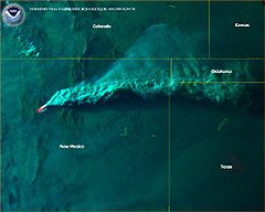
lost their homes in the resulting 48,000 acre (190 km²) fire. Structures at Los Alamos National Laboratory
Los Alamos National Laboratory
Los Alamos National Laboratory is a United States Department of Energy national laboratory, managed and operated by Los Alamos National Security , located in Los Alamos, New Mexico...
were also destroyed or damaged, although without loss or destruction of any of the special nuclear material
Special nuclear material
Special nuclear material is a term used by the Nuclear Regulatory Commission of the United States to classify fissile materials. The NRC divides special nuclear material into three main categories, according to the risk and potential for its direct use in a clandestine nuclear weapon or for its...
housed there. Amazingly, there was no loss of human life. The US General Accounting Office
Government Accountability Office
The Government Accountability Office is the audit, evaluation, and investigative arm of the United States Congress. It is located in the legislative branch of the United States government.-History:...
estimated total damages at one billion US Dollars
United States dollar
The United States dollar , also referred to as the American dollar, is the official currency of the United States of America. It is divided into 100 smaller units called cents or pennies....
.
Prelude
Although wildfireWildfire
A wildfire is any uncontrolled fire in combustible vegetation that occurs in the countryside or a wilderness area. Other names such as brush fire, bushfire, forest fire, desert fire, grass fire, hill fire, squirrel fire, vegetation fire, veldfire, and wilkjjofire may be used to describe the same...
is a natural part of the ecosystem
Ecosystem
An ecosystem is a biological environment consisting of all the organisms living in a particular area, as well as all the nonliving , physical components of the environment with which the organisms interact, such as air, soil, water and sunlight....
of western forests, fire suppression began to be widespread in the late 19th century just as land-use patterns (e.g. intensive grazing
Grazing
Grazing generally describes a type of feeding, in which a herbivore feeds on plants , and also on other multicellular autotrophs...
) limited the cover which had formerly sustained and been sustained by low-intensity ground fires. High-density stands of small trees and thick underbrush permitted a natural periodic ground fire to leap into a high-intensity crown fire. There followed a century of fire suppression, during which large fires occurred on the Pajarito Plateau
Pajarito Plateau
The Pajarito Plateau is a volcanic plateau in north central New Mexico, United States. The plateau, part of the Jemez Mountains, is bounded on the west by the Valles Caldera and on the east by the White Rock Canyon of the Rio Grande...
approximately every twenty years: an 1896 fire, several fires in the 1920s, a fire in 1946, the 1954 Water Canyon Fire
Water Canyon Fire
The Water Canyon Fire of 1954 was a wildfire in the eastern edge of the Jemez Mountains and the Santa Fe National Forest which burned approximately 3,000 to 6,000 acres . The fire started on June 5, 1954 when the burning of trash and construction debris in upper Water Canyon got out of control...
, the 1977 La Mesa Fire
La Mesa Fire
The La Mesa Fire was a wildfire on the Pajarito Plateau of New Mexico, USA, that was human-caused on the afternoon of June 16, 1977. Before it was contained one week later, the fire burned 15,444 acres of Bandelier National Monument and part of Los Alamos National Laboratory, where it reached...
, and the 1996 Dome Fire
Dome Fire
The Dome Fire was a destructive wildfire in the Jemez Mountains in the northern portion of the U.S. state of New Mexico. Devastating portions of the Santa Fe National Forest and Bandelier National Monument, the fire exploded on April 26, 1996, starting from an improperly extinguished campfire and...
.
The 1977 La Mesa Fire served as a wake-up call: it burned 15,000 acres (60 km²) in Bandelier National Monument
Bandelier National Monument
Bandelier National Monument is a National Monument preserving the homes of the Ancestral Pueblo People. It is named after Swiss anthropologist Adolph Bandelier, who researched the cultures of the area. Bandelier was designated a National Monument on February 11, 1916, and most of its backcountry...
, but accelerated a change in attitudes within the National Park Service
National Park Service
The National Park Service is the U.S. federal agency that manages all national parks, many national monuments, and other conservation and historical properties with various title designations...
toward managing fire. On Bandelier National Monument firebreak
Firebreak
A firebreak is a gap in vegetation or other combustible material that acts as a barrier to slow or stop the progress of a bushfire or wildfire. A firebreak may occur naturally where there is a lack of vegetation or "fuel", such as a river, lake or canyon...
s were improved as were fuel breaks, and in some areas trees were thinned. The 1996 Dome Fire burned 16500 acres (67 km²) in nine days and threatened the southern section of Los Alamos National Laboratory. The Dome fire was spectacular, with flame lengths of hundreds of feet, and underscored the problems of passivity and neglect. The Interagency Wildfire Management Team was formed by representatives of Los Alamos National Laboratory, Los Alamos County, Bandelier National Monument, Santa Fe National Forest
Santa Fe National Forest
The Santa Fe National Forest is a protected national forest in northern New Mexico in the Southwestern United States. It was established in 1915 and covers 1,567,181 acres . Elevations range from 5,300 feet to 13,103 feet at the summit of Truchas Peak, located within the Pecos Wilderness...
, State of New Mexico, and Pueblo agencies.
No amount of planning could control the weather, which provided abnormally high precipitation in the early to mid-1990s followed by several years of severe drought. The consequence of these effects was that by 2000, conditions were nearly ideal for a major forest fire on the plateau. Deadfall in the forest had a moisture content lower than that of well-cured firewood
Firewood
Firewood is any wood-like material that is gathered and used for fuel. Generally, firewood is not highly processed and is in some sort of recognizable log or branch form....
. The heavy rains and snows of the mid-1990s had produced luxuriant undergrowth, while the onset of drought toward the end of the decade had dried it out and made it flammable. The stage was set for exactly what happened at Cerro Grande.
Origin
The fire originated as a controlled burnControlled burn
Controlled or prescribed burning, also known as hazard reduction burning or Swailing is a technique sometimes used in forest management, farming, prairie restoration or greenhouse gas abatement. Fire is a natural part of both forest and grassland ecology and controlled fire can be a tool for...
that was part of the 10-year Bandelier National Monument
Bandelier National Monument
Bandelier National Monument is a National Monument preserving the homes of the Ancestral Pueblo People. It is named after Swiss anthropologist Adolph Bandelier, who researched the cultures of the area. Bandelier was designated a National Monument on February 11, 1916, and most of its backcountry...
plan for reducing fire hazard within the monument. The starting point was high on Cerro Grande, a 10,200-foot (3110 m) summit
Summit (topography)
In topography, a summit is a point on a surface that is higher in elevation than all points immediately adjacent to it. Mathematically, a summit is a local maximum in elevation...
on the rim of the Valles Caldera not far north of New Mexico State Road 4
New Mexico State Road 4
New Mexico State Road 4 is a state highway in New Mexico, United States of America. It is significant as the main access route connecting the remote town of Los Alamos, Los Alamos National Laboratory, and Bandelier National Monument to other, more major highways in New Mexico...
, the main highway through Los Alamos County. Like many mountains in the Jemez
Jemez Mountains
The Jemez Mountains are a volcanic group of mountains in New Mexico, United States. The highest point in the range is Chicoma Mountain at an elevation of 11,561 feet . The town of Los Alamos and Los Alamos National Laboratory adjoin the eastern side of the range while the town of Jemez Springs...
, Cerro Grande was mainly covered with coniferous forest
Forest
A forest, also referred to as a wood or the woods, is an area with a high density of trees. As with cities, depending where you are in the world, what is considered a forest may vary significantly in size and have various classification according to how and what of the forest is composed...
, composed largely of ponderosa pine
Ponderosa Pine
Pinus ponderosa, commonly known as the Ponderosa Pine, Bull Pine, Blackjack Pine, or Western Yellow Pine, is a widespread and variable pine native to western North America. It was first described by David Douglas in 1826, from eastern Washington near present-day Spokane...
and aspen
Aspen
Populus section Populus, of the Populus genus, includes the aspen trees and the white poplar Populus alba. The five typical aspens are all native to cold regions with cool summers, in the north of the Northern Hemisphere, extending south at high altitudes in the mountains. The White Poplar, by...
trees, with a characteristic rincon (meadow)
Rincon (meadow)
A rincón is a grass meadow. The term is in wide use in English in the southwest United States, where it refers specifically to a sloping meadow on the south facing upper slopes of a forested mountain...
on its southern slopes near the summit. This grassy area also represented the headwaters of Frijoles Creek (Rito de los Frijoles), which flows southeast into Frijoles Canyon and on to the Rio Grande
Rio Grande
The Rio Grande is a river that flows from southwestern Colorado in the United States to the Gulf of Mexico. Along the way it forms part of the Mexico – United States border. Its length varies as its course changes...
, passing en route the main tourist areas at Bandelier. The plan for the burn (see the NPS summary below) called for initial ignition ("Phase 1") to be in the rincon, followed by flanking fires ("Phase 2") along the slightly higher country east and west of Frijoles Creek. Ignition of the Phase 1 burn was scheduled for May 4, 2000.
In the aftermath of the disaster, Bandelier officials came under intense criticism for this plan, and particularly, for proceeding with it in the face of what appeared to be powerful contraindications. The main point of contention was wind. The Jemez Mountains are prone to strong winds in the spring that frequently exceed 50 miles per hour (80 km/h). Critics insisted that the likelihood of such winds while the controlled burn was in progress was so great, and the risk
Risk
Risk is the potential that a chosen action or activity will lead to a loss . The notion implies that a choice having an influence on the outcome exists . Potential losses themselves may also be called "risks"...
of resulting loss of control so severe, that the burn should never have been attempted at that time of year. At the same time, Bandelier officials faced a most disagreeable dilemma. Proceeding with the burn risked disaster if control was lost, as indeed happened; but failure to do the burn might also be disastrous, because the entire southern slope of Cerro Grande was tinder-dry and ready to ignite catastrophically in the event of a lightning
Lightning
Lightning is an atmospheric electrostatic discharge accompanied by thunder, which typically occurs during thunderstorms, and sometimes during volcanic eruptions or dust storms...
strike (hardly unusual in the Jemez in the spring) or human carelessness with fire. The same winds that militated against starting the controlled burn might then drive the uncontrolled fire toward Los Alamos, with terrible consequences. In any case, the controlled burn was indeed initiated on May 4, and things rapidly got out of hand.
Timeline
- 4 May 2000 Prescribed burn was begun in the late evening.
- 5 May 2000 Control lines were burned through on east side during late morning. Wildland fire declared in early afternoon and a Type 3 incident command established for fire suppressionWildland fire suppressionWildfire suppression refers to the firefighting tactics used to suppress wildfires. Firefighting efforts in wildland areas requires different techniques, equipment, and training from the more familiar structure fire fighting found in populated areas...
. - 6 May 2000 Fire line constructed using pre-existing control lines.
- 7 May 2000 Fire behavior became increasing erratic with spotting by noon.
- 8 May 2000 A Type 1 incident management team assumed command in the early morning. Los Alamos National LaboratoryLos Alamos National LaboratoryLos Alamos National Laboratory is a United States Department of Energy national laboratory, managed and operated by Los Alamos National Security , located in Los Alamos, New Mexico...
closed until further notice. - 10 May 2000 The town of Los Alamos was evacuated at noon. That evening, 235 homes in Los Alamos were destroyed.
- 11 May 2000 The nearby community of White RockWhite Rock, New MexicoWhite Rock is a census-designated place in Los Alamos County, New Mexico, United States. The population was 6,045 at the 2000 census. It is largely a bedroom community for employees of Los Alamos National Laboratory and their families...
was evacuated shortly after midnight, including many evacuees from Los Alamos. - 15 May 2000 Evacuation order was lifted.
- 18 May 2000 Los Alamos residents were allowed to return.
- 22 May 2000 Los Alamos National LaboratoryLos Alamos National LaboratoryLos Alamos National Laboratory is a United States Department of Energy national laboratory, managed and operated by Los Alamos National Security , located in Los Alamos, New Mexico...
began phased reopening. - 6 June 2000 Cerro Grande fire was declared contained.
- 20 July 2000 Cerro Grande fire was declared extinguished.
Flash floods
A particular concern was the possibility of floodFlood
A flood is an overflow of an expanse of water that submerges land. The EU Floods directive defines a flood as a temporary covering by water of land not normally covered by water...
ing in areas downstream of the burned zone. The town of Los Alamos, the national laboratory, and the lower parts of the burned area are all situated on the Pajarito Plateau
Pajarito Plateau
The Pajarito Plateau is a volcanic plateau in north central New Mexico, United States. The plateau, part of the Jemez Mountains, is bounded on the west by the Valles Caldera and on the east by the White Rock Canyon of the Rio Grande...
, an area of extensive canyon
Canyon
A canyon or gorge is a deep ravine between cliffs often carved from the landscape by a river. Rivers have a natural tendency to reach a baseline elevation, which is the same elevation as the body of water it will eventually drain into. This forms a canyon. Most canyons were formed by a process of...
s and mesa
Mesa
A mesa or table mountain is an elevated area of land with a flat top and sides that are usually steep cliffs. It takes its name from its characteristic table-top shape....
s in which surface runoff
Surface runoff
Surface runoff is the water flow that occurs when soil is infiltrated to full capacity and excess water from rain, meltwater, or other sources flows over the land. This is a major component of the water cycle. Runoff that occurs on surfaces before reaching a channel is also called a nonpoint source...
tends to concentrate in the canyon bottoms. This tendency was exacerbated in Cerro Grande's aftermath by the fact that the soil
Soil
Soil is a natural body consisting of layers of mineral constituents of variable thicknesses, which differ from the parent materials in their morphological, physical, chemical, and mineralogical characteristics...
in the burned areas had become hydrophobic
Hydrophobic soil
Hydrophobic soil - soil that is hydrophobic - causes water to collect on the soil surface rather than infiltrate into the ground. Wild fires generally cause soils to be hydrophobic temporarily, which increases water repellency, surface runoff and erosion in post-burn sites...
, raising the specter of drastically increased water flow in the stream
Stream
A stream is a body of water with a current, confined within a bed and stream banks. Depending on its locale or certain characteristics, a stream may be referred to as a branch, brook, beck, burn, creek, "crick", gill , kill, lick, rill, river, syke, bayou, rivulet, streamage, wash, run or...
s in the canyons that the existing streambeds may not have been able to handle. This concern, coupled with the prospect of monsoon
Monsoon
Monsoon is traditionally defined as a seasonal reversing wind accompanied by corresponding changes in precipitation, but is now used to describe seasonal changes in atmospheric circulation and precipitation associated with the asymmetric heating of land and sea...
rains that typically begin in about July in the area, made it urgent to deal with the possibility of flooding.
The highest priority for flood management involved the Los Alamos Critical Experiments Facility (LACEF), a remote site for conducting research in nuclear criticality
Critical mass
A critical mass is the smallest amount of fissile material needed for a sustained nuclear chain reaction. The critical mass of a fissionable material depends upon its nuclear properties A critical mass is the smallest amount of fissile material needed for a sustained nuclear chain reaction. The...
safety that housed substantial quantities of special nuclear material
Special nuclear material
Special nuclear material is a term used by the Nuclear Regulatory Commission of the United States to classify fissile materials. The NRC divides special nuclear material into three main categories, according to the risk and potential for its direct use in a clandestine nuclear weapon or for its...
. The LACEF laboratories
Laboratory
A laboratory is a facility that provides controlled conditions in which scientific research, experiments, and measurement may be performed. The title of laboratory is also used for certain other facilities where the processes or equipment used are similar to those in scientific laboratories...
were in the bottom of Pajarito Canyon. To protect LACEF, a large, temporary "dry dam
Dry dam
A dry dam is a dam constructed for the purpose of flood control. Dry dams typically contain no gates or turbines, and are intended to allow the channel to flow freely during normal conditions...
" was constructed in the canyon upstream of LACEF to temporarily contain flash flood
Flash flood
A flash flood is a rapid flooding of geomorphic low-lying areas—washes, rivers, dry lakes and basins. It may be caused by heavy rain associated with a storm, hurricane, or tropical storm or meltwater from ice or snow flowing over ice sheets or snowfields...
s that might result if an intense thunderstorm
Thunderstorm
A thunderstorm, also known as an electrical storm, a lightning storm, thundershower or simply a storm is a form of weather characterized by the presence of lightning and its acoustic effect on the Earth's atmosphere known as thunder. The meteorologically assigned cloud type associated with the...
happened to rain heavily on the terrain drained by Pajarito Canyon. Runoff was monitored at multiple stations in the headwater streams above Pajarito Canyon.
In the event, the monsoon of the summer of 2000 was not particularly intense, and damage from flooding was generally minimal. No severe flooding occurred in Pajarito Canyon before vegetation upstream had recovered sufficiently, over several years, to retain runoff, and the dry dam eventually was removed. Severe flooding did occur in upper Pueblo Canyon, significantly damaging Diamond Drive, one of the town's arterial roads.
Erosion
Although flash floods were fortuitously minimal, erosion nonetheless was substantial, and many miles of the 57-mile network of trails maintained by Los Alamos County were severely damaged. Canyon bottoms in particular were clogged with fallen trees and boulders washed down from above. Erosion might have been far worse, had there not been timely intervention.A Burned Area Emergency Rehabilitation Team (BAER) was assigned to assess the damage and to implement a rehabilitation
Land rehabilitation
Land rehabilitation is the process of returning the land in a given area to some degree of its former state, after some process has resulted in its damage...
plan to reduce further natural resource damage. During July 2000, approximately 7000 hydromulching and hydroseeding flights by Air Tractor
Air Tractor
Air Tractor Inc. is a United States aircraft manufacturer based in Olney, Texas. Leland Snow founded the company in 1978 in order to manufacture a new agricultural aircraft derived from the S-2B aircraft . Designated Model AT-300 Air Tractor, the new aircraft first flew in 1973...
s were carried out on 1,600 acres (6.5 km²) of the burned area to reduce erosion and speed revegetation. A local trail work organization, Volunteer Task Force, devoted many thousands of hours to rebuilding trails and planting trees. Local school children made many thousands of "seed balls", which they broadcast in the burned areas to accelerate regrowth of the vegetation. To control erosion mechanically, Los Alamos County work crews laid thousands of trees across slopes, and chipped other trees.
Damage to buildings
The presence of Los Alamos National LaboratoryLos Alamos National Laboratory
Los Alamos National Laboratory is a United States Department of Energy national laboratory, managed and operated by Los Alamos National Security , located in Los Alamos, New Mexico...
in and downstream of the burned area posed several unusual problems in remediation, beyond the ones resulting directly from destruction of some of the institution's buildings by fire.
Other problems arose from soot
Soot
Soot is a general term that refers to impure carbon particles resulting from the incomplete combustion of a hydrocarbon. It is more properly restricted to the product of the gas-phase combustion process but is commonly extended to include the residual pyrolyzed fuel particles such as cenospheres,...
generated by the fire, which seeped into buildings, shorting out electrical equipment and clogging HEPA
HEPA
High-Efficiency Particulate Air or HEPA is a type of air filter. Filters that are awarded the HEPA accolade are used in various locations, whether in medical facilities, automotive vehicles, airplanes, home filters, or wherever very pure air is sought. The filter must satisfy certain standards of...
filters necessary to the operation of clean rooms at some of the laboratories. Resolving these problems took several years in some cases.
Meanwhile, the Federal Emergency Management Agency
Federal Emergency Management Agency
The Federal Emergency Management Agency is an agency of the United States Department of Homeland Security, initially created by Presidential Reorganization Plan No. 1 of 1978 and implemented by two Executive Orders...
(FEMA) mobilized to provide relief to the residents of Los Alamos who had been burned out of their homes. A compound of portable building
Portable building
A portable building, or demountable building , is a building designed and built to be movable rather than permanently located. A common modern design is sometimes called a modular building, but portable buildings can be different in that they are more often used temporarily and taken away later....
s ("trailers"), known locally as FEMAville, was constructed on undeveloped land near the county rodeo grounds on North Mesa, providing housing for hundreds of displaced residents. Some residents complained about the timeliness and thoroughness of the FEMA response. The trailers became available only in late June 2000, after municipal utilities were completed and the trailers were delivered and hooked up to the utilities. By 2006 all the trailers were removed and most of the displaced residents were settled into new homes, although reconstruction of houses in the burned area continues . In 2007 the former FEMAville site was proposed as a full service RV park.
Adjacent communities
Santa Clara Canyon, home to Puye Cliff DwellingsPuye Cliff Dwellings
The Puye Cliff Dwellings are the ruins of an abandoned pueblo, located in Santa Clara Canyon on Santa Clara Pueblo land near Española, New Mexico. The site was declared a National Historic Landmark in 1966.-Ancient pueblo dwellings:...
, was devastated by Cerro Grande. The people of Santa Clara Pueblo who formerly earned income through tourism now operate the Big Rock Casino in Española, New Mexico
Española, New Mexico
Española also known as Espanola , is a city primarily in Rio Arriba County, New Mexico, in the United States. A portion of the central and eastern section of the city is in Santa Fe County. Española was founded in 1880 as a railroad village, incorporated as a city in 1925. The city is situated in...
. On June 20, 2000, residents of Isleta and Sandia Pueblo hired four environmental engineers to permanently work with the Cerro Grande Wild Fire aftermath. A forty-member forestry crew with members from the Eight Northern Pueblos
Eight Northern Pueblos
The Eight Northern Pueblos of New Mexico are Taos, Picuris, Santa Clara, San Juan, San Ildefonso, Nambé, Pojoaque, and Tesuque.Taos and Picuris are Tiwa-speaking pueblos; the rest speak Tewa. Tiwa and Tewa are closely related languages of the Kiowa Tanoan language family...
has built 3,000 small dams (to minimize pollution of Santa Clara Creek), and planted one million trees on 3,500 acres (14 km²).
Future
A re-examination of forest fire prevention techniques was already in progress at the time of the Cerro Grande Fire and received added impetus from the damage the fire inflicted. The far larger Rodeo-Chediski fireRodeo-Chediski fire
The Rodeo–Chediski Fire was a wildfire that burned in east-central Arizona beginning on June 18, 2002, and was not controlled until July 7. It was the worst forest fire in Arizona's recorded history until June 14th, 2011 when the Wallow Fire surpassed Rodeo-Chediski as the largest fire in Arizona...
in Arizona
Arizona
Arizona ; is a state located in the southwestern region of the United States. It is also part of the western United States and the mountain west. The capital and largest city is Phoenix...
, as well as several other fires in the western United States in 2002, completed the process of bringing forest fires into political focus, leading to the establishment of the Healthy Forests Initiative
Healthy Forests Initiative
The Healthy Forests Initiative , officially the Healthy Forests Restoration Act of 2003 , is a law originally proposed by President George W. Bush in response to the widespread forest fires during the summer of 2002...
in 2003. This initiative remains controversial, and its applicability to the relatively sparse forests of the Jemez Mountains
Jemez Mountains
The Jemez Mountains are a volcanic group of mountains in New Mexico, United States. The highest point in the range is Chicoma Mountain at an elevation of 11,561 feet . The town of Los Alamos and Los Alamos National Laboratory adjoin the eastern side of the range while the town of Jemez Springs...
that were consumed in the Cerro Grande Fire is unclear. It is certainly clear, however, that significant thinning
Thinning
Thinning is a term used in agricultural sciences to mean the removal of some plants, or parts of plants, to make room for the growth of others.- Forestry :...
of the coniferous forest
Temperate coniferous forests
Temperate coniferous forest is a terrestrial biome found in temperate regions of the world with warm summers and cool winters and adequate rainfall to sustain a forest. In most temperate coniferous forests, evergreen conifers predominate, while some are a mix of conifers and broadleaf evergreen...
of the Jemez has occurred in the years following Cerro Grande.
The local community has also taken many steps to prevent and protect against future wildfires. Steps include removing vegetation around buildings to increase defensible space; replacing roof and sheathing materials (eg, cedar shakes) with less flammable materials; and continued thinning and reduction of fuels in unburned wooded areas in and around town, particularly in the canyons below populated mesas.
A new book on the Cerro Grande Fire has been published in the summer of 2010. Inferno by Committee gives a detailed history of the fire and what went wrong. The book is written by a professional fire fighter.
See also
- 1954 Water Canyon FireWater Canyon FireThe Water Canyon Fire of 1954 was a wildfire in the eastern edge of the Jemez Mountains and the Santa Fe National Forest which burned approximately 3,000 to 6,000 acres . The fire started on June 5, 1954 when the burning of trash and construction debris in upper Water Canyon got out of control...
- 1977 La Mesa FireLa Mesa FireThe La Mesa Fire was a wildfire on the Pajarito Plateau of New Mexico, USA, that was human-caused on the afternoon of June 16, 1977. Before it was contained one week later, the fire burned 15,444 acres of Bandelier National Monument and part of Los Alamos National Laboratory, where it reached...
- 1996 Dome FireDome FireThe Dome Fire was a destructive wildfire in the Jemez Mountains in the northern portion of the U.S. state of New Mexico. Devastating portions of the Santa Fe National Forest and Bandelier National Monument, the fire exploded on April 26, 1996, starting from an improperly extinguished campfire and...
- 1998 Oso Complex FireOso Complex FireThe Oso Complex Fire started June 20, 1998 and burned 5,185 acres in the Santa Fe National Forest in the Jemez Mountains, including more than 1,200 acres of Santa Clara Pueblo land. The fire came within 8 miles of Los Alamos, New Mexico and was contained by July 6, 1998, aided by rain...
- 2011 Las Conchas FireLas Conchas FireThe Las Conchas Fire was a 2011 wildfire in New Mexico, USA. The fire started in Santa Fe National Forest and burned more than 150,000 acres, threatening Los Alamos National Laboratory and the town of Los Alamos...
- List of forest fires