

Cavehill
Encyclopedia
Cavehill, historically known as Ben Madigan (from ), is a basalt
ic hill overlooking the city of Belfast
in Northern Ireland
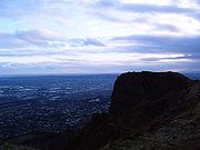
. It forms part of the southeastern border of the Antrim Plateau. It is distinguished by its famous 'Napoleon's Nose', a basaltic outcrop which resembles the profile of the famous emperor Napoleon and is said to have inspired the famous novel Gulliver's Travels
. Cavehill is also the name of an electoral ward in Belfast.
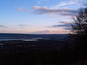
All of Belfast can be seen from its peak, as can the Isle of Man
and Scotland
on clear days. Like Arthur's Seat
in Edinburgh
, it lies just a few miles from the centre of a major city.
estate, which has as its focal point the imposing 19th-century Scottish baronial castle. The castle was designed by Charles Lanyon
and constructed by the Marquess of Donegall
in 1872 in the Deer Park. The slopes of Cavehill were originally used as farmland but, from the 1880s, a major planting exercise was undertaken, producing the now familiar deciduous and coniferous woodland landscape. Belfast Castle estate was given to Belfast city by the 8th Earl of Shaftesbury
in 1934.
for iron-mining.
Adjacent to the lowest cave is 'The Devil's Punchbowl', also sometimes called 'The Devil's Cauldron', a site where ancient Celt
ic farmers corralled their cattle. This consists mainly of a steep hill, mainly of rocks and boulders, and is considered dangerous to amateurs.
or ring fort. It is protected on one side by a precipice and on the others by a single ditch, 10 feet (3 m) in depth and 25 feet (7.6 m) in width; a vallum
of large dimensions. The enclosed area is nearly level. The flat top of the fort is 150 feet (45.7 m) from north to south, and 180 feet (54.9 m) from east to west.
It is believed that the fort's inhabitants used the caves to store white foods for the winter and may have served as a refuge during times of attack.
 The hill was known in the original Gaelic as Beann Mheadagáin (meaning "Madigan's hill"), after one of two Kings of Ulaid
: Matudán mac Muiredaig
, who ruled from 839 to 857 A.D., or a later king, Matudán mac Áeda (reigned 937-950 A.D.). The later king's grandson, Eochaid mac Ardgail, was killed at the battle of Crew Hill in 1004, in which the Men of Ulster were defeated by their old enemies, the Cenél nEógain
. It is from him that McArt's fort derived its name.
The residential neighbourhood at the foot of Cave Hill's entrance is derivatively known as Ben Madigan, with street names to match, and is a wealthy semi-outer city, semi-suburban area. The name 'Ben Madigan' can also be found attached to buildings, schools etc. close to the area, e.g. the Belfast Royal Academy
has the Ben Madigan Preparatory School on the Antrim Road.
United Irishmen Theobald Wolfe Tone
and Henry Joy McCracken
allegedly met at Cavehill in 1795 to take an oath to launch the rebellion of 1798
. McCracken was captured on Cavehill in 1798.
The crowning stone Giant's Chair of the O'Neill clan was apparently sited on Cavehill summit until 1896 and gave its name to the nearby Throne Hospital. The Cavehill Throne was destroyed by loyalists in December 1896 after a reference was made to it in an article in the nationalist paper 'Shan Van Bocht'. Parts of it may be available to view at the Ulster Museum.
During World War II
, a bomb dropped prematurely during a German bombing raid on Belfast exploded, causing a large crater near the grounds of Belfast Castle. It is understood that RAF Bomber Command was situated on Cavehill in the early years of WWII before relocating to Castle Archdale in Fermanagh. Hence the German bomb may have been intentional.
On June 1, 1944, an American Air Force B-17 bomber crashed into Cavehill during heavy fog, killing all ten crew instantly. The incident inspired Richard Attenborough
's film, Closing the Ring
. Some scenes of the film were shot on Cavehill.
basalt lava flows, from 65 million years ago. This is underlain by Cretaceous
—145 million years—Ulster White Limestone and below this is Jurassic
—200 million years—Waterloo Mudstone Formation, more commonly known as Lias clay.
Limestone was mined on the southern flanks of Cavehill in Victorian times and transported to Belfast docks by way of a horse-worked railway along the Limestone Road. The railroad was abandoned in the 1890s. Two small hamlets—Daddystown and Mammystown—were built on either side of the railway track in the early 1820s as dwellings for quarry workers. Some of the local avenues and streets bear the name 'Waterloo', in reference to their geological origins.
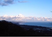
and Belfast Castle are magnets for locals and tourists alike. In the 18th century the townfolk of Belfast flocked there on Easter Monday for the Cavehill fete, near a spring known as the 'Volunteers' Well'. The summits offers stunning views southwards over Belfast City and Lough towards the Mourne Mountains, Scrabo Tower
and Slieve Croob. On a clear day, the eastern prospect reveals views of Carrickfergus
, the Mull of Galloway
in Scotland and the Isle of Man
.
Basalt
Basalt is a common extrusive volcanic rock. It is usually grey to black and fine-grained due to rapid cooling of lava at the surface of a planet. It may be porphyritic containing larger crystals in a fine matrix, or vesicular, or frothy scoria. Unweathered basalt is black or grey...
ic hill overlooking the city of Belfast
Belfast
Belfast is the capital of and largest city in Northern Ireland. By population, it is the 14th biggest city in the United Kingdom and second biggest on the island of Ireland . It is the seat of the devolved government and legislative Northern Ireland Assembly...
in Northern Ireland
Northern Ireland
Northern Ireland is one of the four countries of the United Kingdom. Situated in the north-east of the island of Ireland, it shares a border with the Republic of Ireland to the south and west...
. It forms part of the southeastern border of the Antrim Plateau. It is distinguished by its famous 'Napoleon's Nose', a basaltic outcrop which resembles the profile of the famous emperor Napoleon and is said to have inspired the famous novel Gulliver's Travels
Gulliver's Travels
Travels into Several Remote Nations of the World, in Four Parts. By Lemuel Gulliver, First a Surgeon, and then a Captain of Several Ships, better known simply as Gulliver's Travels , is a novel by Anglo-Irish writer and clergyman Jonathan Swift that is both a satire on human nature and a parody of...
. Cavehill is also the name of an electoral ward in Belfast.
All of Belfast can be seen from its peak, as can the Isle of Man
Isle of Man
The Isle of Man , otherwise known simply as Mann , is a self-governing British Crown Dependency, located in the Irish Sea between the islands of Great Britain and Ireland, within the British Isles. The head of state is Queen Elizabeth II, who holds the title of Lord of Mann. The Lord of Mann is...
and Scotland
Scotland
Scotland is a country that is part of the United Kingdom. Occupying the northern third of the island of Great Britain, it shares a border with England to the south and is bounded by the North Sea to the east, the Atlantic Ocean to the north and west, and the North Channel and Irish Sea to the...
on clear days. Like Arthur's Seat
Arthur's Seat, Edinburgh
Arthur's Seat is the main peak of the group of hills which form most of Holyrood Park, described by Robert Louis Stevenson as "a hill for magnitude, a mountain in virtue of its bold design". It is situated in the centre of the city of Edinburgh, about a mile to the east of Edinburgh Castle...
in Edinburgh
Edinburgh
Edinburgh is the capital city of Scotland, the second largest city in Scotland, and the eighth most populous in the United Kingdom. The City of Edinburgh Council governs one of Scotland's 32 local government council areas. The council area includes urban Edinburgh and a rural area...
, it lies just a few miles from the centre of a major city.
Overview
Cavehill rises to almost 370 metres (1200 ft) above sea level. Most of its lower east side lies on the Belfast CastleBelfast Castle
Belfast Castle is set on the slopes of Cavehill Country Park, Belfast, Northern Ireland in a prominent position above sea level. Its location provides unobstructed views of the city of Belfast and Belfast Lough.-History:...
estate, which has as its focal point the imposing 19th-century Scottish baronial castle. The castle was designed by Charles Lanyon
Charles Lanyon
Sir Charles Lanyon DL, JP was an English architect of the 19th century. His work is most closely associated with Belfast, Northern Ireland.-Biography:Lanyon was born in Eastbourne, Sussex in 1813...
and constructed by the Marquess of Donegall
Marquess of Donegall
Marquess of Donegall is a title in the Peerage of Ireland held by the head of the Chichester family, originally from Devon, England. Sir John Chichester sat as a Member of Parliament and was High Sheriff of Devon in 1557. One of his sons, Sir Arthur Chichester, was Lord Deputy of Ireland from 1604...
in 1872 in the Deer Park. The slopes of Cavehill were originally used as farmland but, from the 1880s, a major planting exercise was undertaken, producing the now familiar deciduous and coniferous woodland landscape. Belfast Castle estate was given to Belfast city by the 8th Earl of Shaftesbury
Anthony Ashley-Cooper, 8th Earl of Shaftesbury
Anthony Ashley-Cooper, 8th Earl of Shaftesbury , styled Lord Ashley between 1851 and 1885, was a British peer, the son of the 7th Earl of Shaftesbury....
in 1934.
The caves
There are three large caves. The lowest is 21 feet (6.4 m) long, 18 feet (5.5 m) wide and varies from 7 to 10 feet (3 m) in height. Above this is another cave; 10 feet (3 m) long, 7 feet (2.1 m) wide and 6 feet (1.8 m) in height. Above this is the third major cave, said to be divided into 2 unequal parts, each of which is more extensive than the larger of the other caves, but the ascent is notoriously dangerous and thus few venture to it.The caves are man-made, and it is postulated that they were originally excavatedEarthworks (engineering)
Earthworks are engineering works created through the moving or processing of quantities of soil or unformed rock.- Civil engineering use :Typical earthworks include roads, railway beds, causeways, dams, levees, canals, and berms...
for iron-mining.
Adjacent to the lowest cave is 'The Devil's Punchbowl', also sometimes called 'The Devil's Cauldron', a site where ancient Celt
Celt
The Celts were a diverse group of tribal societies in Iron Age and Roman-era Europe who spoke Celtic languages.The earliest archaeological culture commonly accepted as Celtic, or rather Proto-Celtic, was the central European Hallstatt culture , named for the rich grave finds in Hallstatt, Austria....
ic farmers corralled their cattle. This consists mainly of a steep hill, mainly of rocks and boulders, and is considered dangerous to amateurs.
McArt's Fort
This fort, on the summit of the hill, is an example of an old ráthRingfort
Ringforts are circular fortified settlements that were mostly built during the Iron Age , although some were built as late as the Early Middle Ages . They are found in Northern Europe, especially in Ireland...
or ring fort. It is protected on one side by a precipice and on the others by a single ditch, 10 feet (3 m) in depth and 25 feet (7.6 m) in width; a vallum
Vallum
Vallum is a term applied either to the whole or a portion of the fortifications of a Roman camp. The vallum usually comprised an earthen or turf rampart with a wooden palisade on top, with a deep outer ditch...
of large dimensions. The enclosed area is nearly level. The flat top of the fort is 150 feet (45.7 m) from north to south, and 180 feet (54.9 m) from east to west.
It is believed that the fort's inhabitants used the caves to store white foods for the winter and may have served as a refuge during times of attack.
History
Ulaid
The Ulaid or Ulaidh were a people of early Ireland who gave their name to the modern province of Ulster...
: Matudán mac Muiredaig
Matudán mac Muiredaig
Matudán mac Muiredaig was a Dal Fiatach king of Ulaid, which is now Ulster, Ireland. He was the son of Muiredach mac Eochada , the previous king. He ruled from 839-857.-Biography:His father had been killed by his own brother Áed...
, who ruled from 839 to 857 A.D., or a later king, Matudán mac Áeda (reigned 937-950 A.D.). The later king's grandson, Eochaid mac Ardgail, was killed at the battle of Crew Hill in 1004, in which the Men of Ulster were defeated by their old enemies, the Cenél nEógain
Cenél nEógain
Cenél nEóġain is the name of the "kindred" or descendants of Eógan mac Néill , son of Niall Noígiallach who founded the kingdom of Tír Eoghain in the 5th century...
. It is from him that McArt's fort derived its name.
The residential neighbourhood at the foot of Cave Hill's entrance is derivatively known as Ben Madigan, with street names to match, and is a wealthy semi-outer city, semi-suburban area. The name 'Ben Madigan' can also be found attached to buildings, schools etc. close to the area, e.g. the Belfast Royal Academy
Belfast Royal Academy
The Belfast Royal Academy is the oldest school in the city of Belfast, Northern Ireland. It is a co-educational, non-denominational voluntary grammar school situated in north Belfast. The Academy is one of eight Northern Irish schools whose Headmaster is a member of the Headmasters' and...
has the Ben Madigan Preparatory School on the Antrim Road.
United Irishmen Theobald Wolfe Tone
Theobald Wolfe Tone
Theobald Wolfe Tone or Wolfe Tone , was a leading Irish revolutionary figure and one of the founding members of the United Irishmen and is regarded as the father of Irish Republicanism. He was captured by British forces at Lough Swilly in Donegal and taken prisoner...
and Henry Joy McCracken
Henry Joy McCracken
Henry Joy McCracken was an Irish industrialist and a founding member of the Society of the United Irishmen.-History:...
allegedly met at Cavehill in 1795 to take an oath to launch the rebellion of 1798
Irish Rebellion of 1798
The Irish Rebellion of 1798 , also known as the United Irishmen Rebellion , was an uprising in 1798, lasting several months, against British rule in Ireland...
. McCracken was captured on Cavehill in 1798.
The crowning stone Giant's Chair of the O'Neill clan was apparently sited on Cavehill summit until 1896 and gave its name to the nearby Throne Hospital. The Cavehill Throne was destroyed by loyalists in December 1896 after a reference was made to it in an article in the nationalist paper 'Shan Van Bocht'. Parts of it may be available to view at the Ulster Museum.
During World War II
World War II
World War II, or the Second World War , was a global conflict lasting from 1939 to 1945, involving most of the world's nations—including all of the great powers—eventually forming two opposing military alliances: the Allies and the Axis...
, a bomb dropped prematurely during a German bombing raid on Belfast exploded, causing a large crater near the grounds of Belfast Castle. It is understood that RAF Bomber Command was situated on Cavehill in the early years of WWII before relocating to Castle Archdale in Fermanagh. Hence the German bomb may have been intentional.
On June 1, 1944, an American Air Force B-17 bomber crashed into Cavehill during heavy fog, killing all ten crew instantly. The incident inspired Richard Attenborough
Richard Attenborough
Richard Samuel Attenborough, Baron Attenborough , CBE is a British actor, director, producer and entrepreneur. As director and producer he won two Academy Awards for the 1982 film Gandhi...
's film, Closing the Ring
Closing the Ring
Closing the Ring is a film directed by Richard Attenborough and starring Shirley MacLaine, Christopher Plummer, Mischa Barton, Stephen Amell, Neve Campbell, Pete Postlethwaite, and Brenda Fricker....
. Some scenes of the film were shot on Cavehill.
Geology
The hill owes it characteristic shape to TertiaryTertiary
The Tertiary is a deprecated term for a geologic period 65 million to 2.6 million years ago. The Tertiary covered the time span between the superseded Secondary period and the Quaternary...
basalt lava flows, from 65 million years ago. This is underlain by Cretaceous
Cretaceous
The Cretaceous , derived from the Latin "creta" , usually abbreviated K for its German translation Kreide , is a geologic period and system from circa to million years ago. In the geologic timescale, the Cretaceous follows the Jurassic period and is followed by the Paleogene period of the...
—145 million years—Ulster White Limestone and below this is Jurassic
Jurassic
The Jurassic is a geologic period and system that extends from about Mya to Mya, that is, from the end of the Triassic to the beginning of the Cretaceous. The Jurassic constitutes the middle period of the Mesozoic era, also known as the age of reptiles. The start of the period is marked by...
—200 million years—Waterloo Mudstone Formation, more commonly known as Lias clay.
Limestone was mined on the southern flanks of Cavehill in Victorian times and transported to Belfast docks by way of a horse-worked railway along the Limestone Road. The railroad was abandoned in the 1890s. Two small hamlets—Daddystown and Mammystown—were built on either side of the railway track in the early 1820s as dwellings for quarry workers. Some of the local avenues and streets bear the name 'Waterloo', in reference to their geological origins.
Tourism and recreation
Cavehill Country Park, Belfast ZooBelfast Zoo
Belfast Zoological Gardens is a zoo in Belfast, Northern Ireland. It is located in a relatively secluded location on the northeastern slope of Cavehill, overlooking Belfast's Antrim Road, resulting in a uniquely tranquil environment for the animals that the zoo is frequently praised for.-About the...
and Belfast Castle are magnets for locals and tourists alike. In the 18th century the townfolk of Belfast flocked there on Easter Monday for the Cavehill fete, near a spring known as the 'Volunteers' Well'. The summits offers stunning views southwards over Belfast City and Lough towards the Mourne Mountains, Scrabo Tower
Scrabo Tower
Scrabo Tower is located to the west of Newtownards in County Down, Northern Ireland.The landmark, which is visible from most of north Down, was built on a volcanic plug above the town in 1857 as a memorial to Charles Stewart, 3rd Marquess of Londonderry who was one of the Duke of Wellington's...
and Slieve Croob. On a clear day, the eastern prospect reveals views of Carrickfergus
Carrickfergus
Carrickfergus , known locally and colloquially as "Carrick", is a large town in County Antrim, Northern Ireland. It is located on the north shore of Belfast Lough, from Belfast. The town had a population of 27,201 at the 2001 Census and takes its name from Fergus Mór mac Eirc, the 6th century king...
, the Mull of Galloway
Mull of Galloway
The Mull of Galloway is the southernmost point of Scotland. It is situated in Wigtownshire, Dumfries and Galloway.A lighthouse is positioned at the point . Built in 1830 by engineer Robert Stevenson, the white-painted round tower is high...
in Scotland and the Isle of Man
Isle of Man
The Isle of Man , otherwise known simply as Mann , is a self-governing British Crown Dependency, located in the Irish Sea between the islands of Great Britain and Ireland, within the British Isles. The head of state is Queen Elizabeth II, who holds the title of Lord of Mann. The Lord of Mann is...
.