
Catalina Highway
Encyclopedia
The Catalina Highway, officially the General Hitchcock Highway, is the popular name for a Forest Highway
and scenic route
located in Pima County
in southern Arizona
. Also known as the Sky Island Scenic Byway, the Mount Lemmon Highway and Arizona Forest Highway 39, the Catalina Highway is the only paved roadway providing access to the resort village of Summerhaven
as well as various recreational and scientific facilities located near the summit of Mount Lemmon
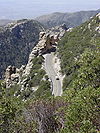
. Ascending from the desert floor in Tucson to near the summit of Mount Lemmon, the short highway gains over 6000 ft (1.8 km), showcasing a variety of climates ranging from lowland desert to alpine forests
. The name sky island
comes from the analogy of these mountains being like islands of forest in a sea of desert. It is designated as a scenic byway by the National Scenic Byways Program. and an Arizona Scenic Road by the Federal Highway Administration
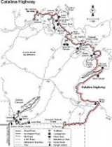
 The Catalina Highway begins at its intersection with Tanque Verde Road in northeast Tucson, traversing the unincorporated community of Tanque Verde
before crossing into the Coronado National Forest
. At this point, the roadway officially becomes the General Hitchcock Highway (Arizona Forest Highway 39), although many maps reflect the common usage of "Catalina Highway" to refer to the entire roadway.
From the boundary with the National Forest, the highway takes a winding route through the Santa Catalina Mountains
. Due to the rapid gain in elevation there are numerous switchbacks, but the road follows a generally northward direction until reaching Forest Road 9 and Rose Canyon Lake
, after which it begins traveling in a generally northwestern direction to the village of Summerhaven.
The final segment of the road, sometimes signed as Ski Run Road, heads east to the Mount Lemmon Ski Valley
and ultimately approaches its final terminus near the summit of Mount Lemmon.
 Construction on the Catalina Highway began in 1933, owing in large part to the efforts of Frank Harris Hitchcock, former Postmaster General of the United States. Desirous to create a route to the popular destinations at the summit of Mount Lemmon, Hitchcock spearheaded the effort to bring together the funds and resources to construct an improved road to Summerhaven and nearby facilities. As a part of the effort, a federal prison camp was established at the foot of the mountains specifically to supply labor for the construction of the highway. During the events of World War II
, the camp was converted into an internment camp
named the Catalina Honor Camp, and the internees were forced to work on construction of the roadway. One of the Japanese-American prisoners at the camp, Gordon Hirabayashi
, was later honored in 1999 when the remains of the Honor Camp were converted into the Gordon Hirabayashi Recreation Area.
The highway would not be completed until 1950, 17 years after it began. Hitchcock, who had passed away in 1935, was memorialized when the highway was named after him upon its completion.
The original paved road was narrow, in places had little or no shoulder, featured an impressive array of vertical drop-offs near the road, and was bumpy along most of its length due to years of patchwork repairs. It was long regarded as "one of the most dangerous roads in Pima County." Though this moniker was not entirely accurate or deserved, there were certainly sections that could be distressing for anyone who disliked heights. In 1988, the Federal Lands Highway program began a series of seven projects aimed at significantly improving the roadway, with the assistance of the US Forest Service and Pima County. The projects were aimed at improving the quality of the roadway and increasing safety for travelers, while minimizing the impact on the visual aspects and natural beauty of the surrounding mountains. The final project was completed in 2007, at a cost of $15 million, and the road is now an altogether pleasant experience, being much wider and featuring adequate shoulders, passing areas, and extensive guard rails.
The roadway was awarded with the Arizona Engineering Excellence Grand Award for Context Sensitive Design in 2005 for minimizing damage to existing terrain and pinnacles and careful preservation of the delicate environment.
 The Catalina Highway provides the only paved access to attractions on Mount Lemmon and the Santa Catalina Mountains, and has become a popular destination for tourism in the region. According to the Federal Highway Administration, the Catalina Highway is traveled over by more than one million visitors every year. Among the many recreational opportunities in the Coronado National Forest, through which the highway travels, are numerous campgrounds
and picnic sites, hiking trails, and scenic views. The Mount Lemmon Ski Valley, located at the summit of the highway, operates a ski slope during the winter months and remains open during the summer, offering summer "sky rides" on the ski lift. It is billed as the southernmost ski resort in the continental United States.
In addition to the numerous recreational activities the highway offers access to, the highway's status as a Scenic Drive is a draw in and of itself. The Forest Service describes the drive as a biological and ecological tour from Mexico
to Canada
in only 27 miles. Over the length of the drive, visitors will encounter saguaro
cacti, mesquite
trees, and cholla
plants of the Sonoran Desert
, pass through stands of oak
, juniper
, and pinyon pine
, enter pine
forests and then finally stands of fir
and aspen
on the cooler, north-facing slopes at the end of the highway.
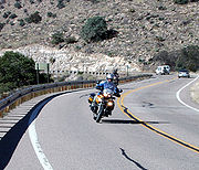
The scenic vistas afforded along the highway, along with the terrain, make it a common destination for leisure travel and motorcycling. The route is also popular with bicycling enthusiasts, providing a significant challenge of skill. Local cycling organizations regularly organize rides consisting of 200 or more riders along the highway to the summit of the mountain.
October 2010 saw the inaugural running of the Mount Lemmon Marathon
which saw nearly 800 participants finish the race from near the start of the highway up to Summerhaven.
.
Forest Highway
Forest Highways or Forest Routes are a category of roads within United States National Forests. They are built to connect the national forests to the existing state highway systems, and to provide improved access to recreational and logging areas....
and scenic route
Scenic route
A scenic route, tourist road, tourist route, theme route, or scenic byway is a specially designated road or waterway that travels through an area of natural or cultural beauty...
located in Pima County
Pima County, Arizona
-2010:Whereas according to the 2010 U.S. Census Bureau:*74.3% White*3.5% Black*3.3% Native American*2.6% Asian*0.2% Native Hawaiian or Pacific Islander*3.7% Two or more races*12.4% Other races*34.6% Hispanic or Latino -2000:...
in southern Arizona
Arizona
Arizona ; is a state located in the southwestern region of the United States. It is also part of the western United States and the mountain west. The capital and largest city is Phoenix...
. Also known as the Sky Island Scenic Byway, the Mount Lemmon Highway and Arizona Forest Highway 39, the Catalina Highway is the only paved roadway providing access to the resort village of Summerhaven
Summerhaven, Arizona
Summerhaven is a small Census-designated place on Mount Lemmon in the Santa Catalina Mountains north of Tucson in Pima County, Arizona, United States. Summerhaven sits at an elevation of approximately 8,200 feet...
as well as various recreational and scientific facilities located near the summit of Mount Lemmon
Mount Lemmon
Mount Lemmon is in the Santa Catalina Mountains located in the Coronado National Forest north of Tucson, Arizona, United States. It is above sea-level, and receives approximately 180 inches of snow annually. Mount Lemmon was named in honor of botanist Sarah Lemmon, who trekked to the top of...
. Ascending from the desert floor in Tucson to near the summit of Mount Lemmon, the short highway gains over 6000 ft (1.8 km), showcasing a variety of climates ranging from lowland desert to alpine forests
Alpine climate
Alpine climate is the average weather for a region above the tree line. This climate is also referred to as mountain climate or highland climate....
. The name sky island
Sky island
Sky islands are mountains that are isolated by surrounding lowlands of a dramatically different environment, a situation which, in combination with the altitudinal zonation of ecosystems, has significant implications for natural habitats. Endemism, vertical migration, and relict populations are...
comes from the analogy of these mountains being like islands of forest in a sea of desert. It is designated as a scenic byway by the National Scenic Byways Program. and an Arizona Scenic Road by the Federal Highway Administration
Federal Highway Administration
The Federal Highway Administration is a division of the United States Department of Transportation that specializes in highway transportation. The agency's major activities are grouped into two "programs," the Federal-aid Highway Program and the Federal Lands Highway Program...
Route description
Tanque Verde, Arizona
Tanque Verde is a suburban census-designated place in Pima County, Arizona, United States, northeast of Tucson. The population was 16,195 at the 2000 census.- History :...
before crossing into the Coronado National Forest
Coronado National Forest
The Coronado National Forest includes an area of about 1.78 million acres spread throughout mountain ranges in southeastern Arizona and southwestern New Mexico....
. At this point, the roadway officially becomes the General Hitchcock Highway (Arizona Forest Highway 39), although many maps reflect the common usage of "Catalina Highway" to refer to the entire roadway.
From the boundary with the National Forest, the highway takes a winding route through the Santa Catalina Mountains
Santa Catalina Mountains
The Santa Catalina Mountains, commonly referred to as the Catalina Mountains, are located north, and northeast of Tucson, Arizona, United States, on Tucson's north perimeter. The mountain range is the most prominent in the Tucson area, with the highest average elevation...
. Due to the rapid gain in elevation there are numerous switchbacks, but the road follows a generally northward direction until reaching Forest Road 9 and Rose Canyon Lake
Rose Canyon Lake
Rose Canyon Lake is located northeast of Tucson, Arizona.-External links:***...
, after which it begins traveling in a generally northwestern direction to the village of Summerhaven.
The final segment of the road, sometimes signed as Ski Run Road, heads east to the Mount Lemmon Ski Valley
Mount Lemmon Ski Valley
Mount Lemmon Ski Valley is a recreational ski area in the U.S. state of Arizona, and the southernmost ski destination in the continental United States. Mount Lemmon Ski Valley is located on the slopes of Mount Lemmon in the Santa Catalina Mountains just north of Tucson, Arizona. It is part of the...
and ultimately approaches its final terminus near the summit of Mount Lemmon.
History
World War II
World War II, or the Second World War , was a global conflict lasting from 1939 to 1945, involving most of the world's nations—including all of the great powers—eventually forming two opposing military alliances: the Allies and the Axis...
, the camp was converted into an internment camp
Japanese American internment
Japanese-American internment was the relocation and internment by the United States government in 1942 of approximately 110,000 Japanese Americans and Japanese who lived along the Pacific coast of the United States to camps called "War Relocation Camps," in the wake of Imperial Japan's attack on...
named the Catalina Honor Camp, and the internees were forced to work on construction of the roadway. One of the Japanese-American prisoners at the camp, Gordon Hirabayashi
Gordon Hirabayashi
Gordon Kiyoshi Hirabayashi is an American sociologist , best known for his principled resistance to the Japanese American internment during World War II, and the court case which bears his name, Hirabayashi v. United States.-Biography:Hirabayashi was born in Seattle to a Christian family who were...
, was later honored in 1999 when the remains of the Honor Camp were converted into the Gordon Hirabayashi Recreation Area.
The highway would not be completed until 1950, 17 years after it began. Hitchcock, who had passed away in 1935, was memorialized when the highway was named after him upon its completion.
The original paved road was narrow, in places had little or no shoulder, featured an impressive array of vertical drop-offs near the road, and was bumpy along most of its length due to years of patchwork repairs. It was long regarded as "one of the most dangerous roads in Pima County." Though this moniker was not entirely accurate or deserved, there were certainly sections that could be distressing for anyone who disliked heights. In 1988, the Federal Lands Highway program began a series of seven projects aimed at significantly improving the roadway, with the assistance of the US Forest Service and Pima County. The projects were aimed at improving the quality of the roadway and increasing safety for travelers, while minimizing the impact on the visual aspects and natural beauty of the surrounding mountains. The final project was completed in 2007, at a cost of $15 million, and the road is now an altogether pleasant experience, being much wider and featuring adequate shoulders, passing areas, and extensive guard rails.
The roadway was awarded with the Arizona Engineering Excellence Grand Award for Context Sensitive Design in 2005 for minimizing damage to existing terrain and pinnacles and careful preservation of the delicate environment.
Tourism
Camping
Camping is an outdoor recreational activity. The participants leave urban areas, their home region, or civilization and enjoy nature while spending one or several nights outdoors, usually at a campsite. Camping may involve the use of a tent, caravan, motorhome, cabin, a primitive structure, or no...
and picnic sites, hiking trails, and scenic views. The Mount Lemmon Ski Valley, located at the summit of the highway, operates a ski slope during the winter months and remains open during the summer, offering summer "sky rides" on the ski lift. It is billed as the southernmost ski resort in the continental United States.
In addition to the numerous recreational activities the highway offers access to, the highway's status as a Scenic Drive is a draw in and of itself. The Forest Service describes the drive as a biological and ecological tour from Mexico
Mexico
The United Mexican States , commonly known as Mexico , is a federal constitutional republic in North America. It is bordered on the north by the United States; on the south and west by the Pacific Ocean; on the southeast by Guatemala, Belize, and the Caribbean Sea; and on the east by the Gulf of...
to Canada
Canada
Canada is a North American country consisting of ten provinces and three territories. Located in the northern part of the continent, it extends from the Atlantic Ocean in the east to the Pacific Ocean in the west, and northward into the Arctic Ocean...
in only 27 miles. Over the length of the drive, visitors will encounter saguaro
Saguaro
The saguaro is a large, tree-sized cactus species in the monotypic genus Carnegiea. It is native to the Sonoran Desert in the U.S. state of Arizona, the Mexican state of Sonora, a small part of Baja California in the San Felipe Desert and an extremely small area of California, U.S...
cacti, mesquite
Mesquite
Mesquite is a leguminous plant of the Prosopis genus found in northern Mexico through the Sonoran Desert and Chihuahuan Deserts, and up into the Southwestern United States as far north as southern Kansas, west to the Colorado Desert in California,and east to the eastern fifth of Texas, where...
trees, and cholla
Opuntia
Opuntia, also known as nopales or paddle cactus , is a genus in the cactus family, Cactaceae.Currently, only prickly pears are included in this genus of about 200 species distributed throughout most of the Americas. Chollas are now separated into the genus Cylindropuntia, which some still consider...
plants of the Sonoran Desert
Sonoran Desert
The Sonoran Desert is a North American desert which straddles part of the United States-Mexico border and covers large parts of the U.S. states of Arizona and California and the northwest Mexican states of Sonora, Baja California, and Baja California Sur. It is one of the largest and hottest...
, pass through stands of oak
Oak
An oak is a tree or shrub in the genus Quercus , of which about 600 species exist. "Oak" may also appear in the names of species in related genera, notably Lithocarpus...
, juniper
Juniper
Junipers are coniferous plants in the genus Juniperus of the cypress family Cupressaceae. Depending on taxonomic viewpoint, there are between 50-67 species of juniper, widely distributed throughout the northern hemisphere, from the Arctic, south to tropical Africa in the Old World, and to the...
, and pinyon pine
Pinyon pine
The pinyon pine group grows in the southwestern United States and in Mexico. The trees yield edible pinyon nuts, which were a staple of the Native Americans, and are still widely eaten...
, enter pine
Pine
Pines are trees in the genus Pinus ,in the family Pinaceae. They make up the monotypic subfamily Pinoideae. There are about 115 species of pine, although different authorities accept between 105 and 125 species.-Etymology:...
forests and then finally stands of fir
Fir
Firs are a genus of 48–55 species of evergreen conifers in the family Pinaceae. They are found through much of North and Central America, Europe, Asia, and North Africa, occurring in mountains over most of the range...
and aspen
Aspen
Populus section Populus, of the Populus genus, includes the aspen trees and the white poplar Populus alba. The five typical aspens are all native to cold regions with cool summers, in the north of the Northern Hemisphere, extending south at high altitudes in the mountains. The White Poplar, by...
on the cooler, north-facing slopes at the end of the highway.
The scenic vistas afforded along the highway, along with the terrain, make it a common destination for leisure travel and motorcycling. The route is also popular with bicycling enthusiasts, providing a significant challenge of skill. Local cycling organizations regularly organize rides consisting of 200 or more riders along the highway to the summit of the mountain.
October 2010 saw the inaugural running of the Mount Lemmon Marathon
Mount Lemmon Marathon
The Mount Lemmon Marathon is an annual marathon that takes place in the Santa Catalina Mountains near the city of Tucson, Arizona, United States. The race starts near the desert floor and ends at the village of Summerhaven near the top of Mount Lemmon. It is noted for the entire course being...
which saw nearly 800 participants finish the race from near the start of the highway up to Summerhaven.
Major intersections
The entire route is located in Pima CountyPima County, Arizona
-2010:Whereas according to the 2010 U.S. Census Bureau:*74.3% White*3.5% Black*3.3% Native American*2.6% Asian*0.2% Native Hawaiian or Pacific Islander*3.7% Two or more races*12.4% Other races*34.6% Hispanic or Latino -2000:...
.
| Location | Mile | Destination | Notes |
|---|---|---|---|
| Tucson Tucson, Arizona Tucson is a city in and the county seat of Pima County, Arizona, United States. The city is located 118 miles southeast of Phoenix and 60 miles north of the U.S.-Mexico border. The 2010 United States Census puts the city's population at 520,116 with a metropolitan area population at 1,020,200... |
0 | Tanque Verde Road | Terminus |
| Harrison Road | |||
| Prince Road | |||
| Houghton Road | |||
| Snyder Road | |||
| 27 | Dead end near Mt. Lemmon | Terminus |