

Castleguard Cave
Encyclopedia
Castleguard Cave is a limestone cave
located at the north end of Banff National Park
in the Rocky Mountains
of Canada
. With 20,357m of surveyed passages (as of 2007), it is Canada's longest cave, and its fifth deepest at 384m. Castleguard Cave ascends gently from its entrance and terminates beneath the Columbia Icefield
.
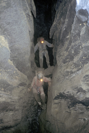
This attention is due in part to its magnificent, remote mountain setting. Its location within a protected area in a national park prohibits motorized ground access, and the risk of flooding in its entrance has limited most explorations to mid or late winter, so cavers must access it via a 20 km (12 mi) alpine ski with towed sleds, or by helicopter. This feeling of remoteness is compounded by the cave's linear layout and its single entrance. The classic trip, from the entrance to the Ice Plug by the shortest route, traverses 9 km (6 mi) of cave passage. Cavers often are underground for four or five days, staying at two underground camps.
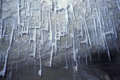
Most northern caves are not well decorated with cave formations, but Castleguard Cave has some sections with good flowstone
and stalactite
s, and is known for its nest of exceedingly rare cubic cave pearls and extensive displays of flagged soda straw
s. The back passages of Castleguard Cave are the only ones in the world that end in plugs of glacial ice pushed into the cave from the sole of a surface icefield.
It has been suggested that the cave was a refuge for the isopods and other life found in its pools during periods of glaciation. One unique species, the amphipod Stygobromus Canadensis, was identified in 1977.
 Castleguard Cave lies within the Cathedral Formation limestone, except the headward complex which is in the overlying Stephen Formation shaley limestones. Their gently-dipping bedding (about 5 degrees) is reflected in the near-horizontal aspect of the cave. Although the entrance and headwater sections are more complex, the central portion of the cave consists of a single main passage alternating between long sections of vadose
(rift or canyon) passages linked by shorter phreatic
(tubular) sections. Much of the cave is dry, excepting the entrance series which floods unpredictably in summer.
Castleguard Cave has had a long genesis. The accessible, explored portion of the cave, sometimes referred to as Castleguard 1, is a long-abandoned drain. Studies of pollen
found within cave sediments suggest that these cave passages were fully developed and dewatered at least 1M years before present. It is postulated that an underlying cave, Castleguard 2, carries the present-day glacial drainage, resurging at Big Springs. A third cave system, Castleguard 3, collects surface melt from Castleguard Meadows at right-angles to the main cave, joining it somewhere prior to the Big Springs resurgence. Castleguard 3 has been proven by dye tracing
and has not been entered to any significant degree by cavers.
and is under the jurisdiction of Parks Canada
. The entrance has been gated and access has been restricted since the 1970s. Local cavers have worked with Parks Canada to ensure that permits are available to qualified parties upon application.
 Undoubtedly the cave was known to natives throughout prehistory, but the first recorded visit was by Cecil Smith, an outfitter rounding up stray horses during a guided trip to Castleguard Meadows in 1921. Smith's client happened to be the head of the U.S. Geological Survey, and three years later the cave entrance was revisited and photographed as part of an article on the Columbia Icefield
for National Geographic magazine
.
Sporadic local visitations likely continued for many years, but the first formal investigations were in the summer of 1967 by members of the Karst Research Group (from McMaster University
in Hamilton, Ontario
) led by Dr. Derek Ford, following up on a tip from a local outdoorsman. KRG teams penetrated past the cave's first obstacle, an 8m drop, and explored the main trunk passage. After Peter Thompson and Mike Boon were trapped in the cave by sudden flooding near the entrance, explorations were limited to mid or late winter, with attendant difficulties. The Ice Plug, the 'end' of the cave, was discovered by Mike Boon during a controversial solo trip in the winter of 1970. Soon thereafter cavers helped produce The Longest Cave, a National Film Board production, during which some side passages were explored.
Explorations slowed somewhat following national park access restrictions, but picked up again in the 1980s when most of the major side passages (including Boulevard du Quebec and extensions to Thompson's Terror) were explored by Canadian and international teams, bringing Castleguard Cave to a length exceeding 20 kilometres. Such explorations continue today, but with diminishing returns as the major leads have all been checked.
In 2005, a Norwegian group spent three days bolt-climbing the '200-foot aven', a vertical shaft going straight up from the cave level about halfway in, slightly inside of the site known as 'Camp One'. The measured height was 68 metres to the floor of the top chamber. Somewhat to the disappointment of the explorers the chamber narrows to an impassable crack; however, in caving first impressions are not always authoritative and there is still some hope of further penetration in that area.
A Canadian-supported team from the UK dived the sump at Boon's Blunder in 2009 and 2010, reaching substantial dry phreatic passage, after a dive of 845m. Exploration of these passages is expected early 2012.
Concurrent with exploration was the survey
, or mapping, of the cave. Data was held at a number of sources, and doubts about completeness or consistency of standards led to a remapping project coordinated by Steve Worthington and supported by cave radio location work by Ian Drummond. But the prospects of hand-drafting a map seven metres long were daunting, and production was delayed until the arrival of computer technology. After further work on verification, addition of passage detail and survey of various unchecked leads, a final map in digital format was produced late in 2005 and is updated whenever new mapping occurs.
Cave
A cave or cavern is a natural underground space large enough for a human to enter. The term applies to natural cavities some part of which is in total darkness. The word cave also includes smaller spaces like rock shelters, sea caves, and grottos.Speleology is the science of exploration and study...
located at the north end of Banff National Park
Banff National Park
Banff National Park is Canada's oldest national park, established in 1885 in the Rocky Mountains. The park, located 110–180 kilometres west of Calgary in the province of Alberta, encompasses of mountainous terrain, with numerous glaciers and ice fields, dense coniferous forest, and alpine...
in the Rocky Mountains
Rocky Mountains
The Rocky Mountains are a major mountain range in western North America. The Rocky Mountains stretch more than from the northernmost part of British Columbia, in western Canada, to New Mexico, in the southwestern United States...
of Canada
Canada
Canada is a North American country consisting of ten provinces and three territories. Located in the northern part of the continent, it extends from the Atlantic Ocean in the east to the Pacific Ocean in the west, and northward into the Arctic Ocean...
. With 20,357m of surveyed passages (as of 2007), it is Canada's longest cave, and its fifth deepest at 384m. Castleguard Cave ascends gently from its entrance and terminates beneath the Columbia Icefield
Columbia Icefield
The Columbia Icefield is an icefield located in the Canadian Rockies, astride the Continental Divide of North America. The icefield lies partly in the northwestern tip of Banff National Park and the southern end of Jasper National Park. It is about 325 km² in area, 100 to 365 metres in depth and...
.
General information
Castleguard Cave is modest in size compared to other great caves of the world, but nevertheless is well known amongst cavers and speleologists internationally. It is the subject of a film and a coffee-table book, and is mentioned in most cave reference books in print.This attention is due in part to its magnificent, remote mountain setting. Its location within a protected area in a national park prohibits motorized ground access, and the risk of flooding in its entrance has limited most explorations to mid or late winter, so cavers must access it via a 20 km (12 mi) alpine ski with towed sleds, or by helicopter. This feeling of remoteness is compounded by the cave's linear layout and its single entrance. The classic trip, from the entrance to the Ice Plug by the shortest route, traverses 9 km (6 mi) of cave passage. Cavers often are underground for four or five days, staying at two underground camps.
Most northern caves are not well decorated with cave formations, but Castleguard Cave has some sections with good flowstone
Flowstone
Flowstones are composed of sheetlike deposits of calcite formed where water flows down the walls or along the floors of a cave. They are typically found in "solution", or limestone caves, where they are the most common speleothem. However, they may form in any type of cave where water enters that...
and stalactite
Stalactite
A stalactite , "to drip", and meaning "that which drips") is a type of speleothem that hangs from the ceiling of limestone caves. It is a type of dripstone...
s, and is known for its nest of exceedingly rare cubic cave pearls and extensive displays of flagged soda straw
Soda straw
A soda straw is a speleothem in the form of a hollow mineral tube. They grow in places where water leaches slowly through cracks in rock, such as on the roofs of caves...
s. The back passages of Castleguard Cave are the only ones in the world that end in plugs of glacial ice pushed into the cave from the sole of a surface icefield.
It has been suggested that the cave was a refuge for the isopods and other life found in its pools during periods of glaciation. One unique species, the amphipod Stygobromus Canadensis, was identified in 1977.
Cave setting and form
Vadose zone
The vadose zone, also termed the unsaturated zone, is the portion of Earth between the land surface and the top of the phreatic zone i.e. the position at which the groundwater is at atmospheric pressure . Hence the vadose zone extends from the top of the ground surface to the water table...
(rift or canyon) passages linked by shorter phreatic
Phreatic
The term phreatic is used in Earth sciences to refer to matters relating to ground water below the water table . The term 'phreatic surface' indicates the location where the pore water pressure is under atmospheric conditions...
(tubular) sections. Much of the cave is dry, excepting the entrance series which floods unpredictably in summer.
Castleguard Cave has had a long genesis. The accessible, explored portion of the cave, sometimes referred to as Castleguard 1, is a long-abandoned drain. Studies of pollen
Pollen
Pollen is a fine to coarse powder containing the microgametophytes of seed plants, which produce the male gametes . Pollen grains have a hard coat that protects the sperm cells during the process of their movement from the stamens to the pistil of flowering plants or from the male cone to the...
found within cave sediments suggest that these cave passages were fully developed and dewatered at least 1M years before present. It is postulated that an underlying cave, Castleguard 2, carries the present-day glacial drainage, resurging at Big Springs. A third cave system, Castleguard 3, collects surface melt from Castleguard Meadows at right-angles to the main cave, joining it somewhere prior to the Big Springs resurgence. Castleguard 3 has been proven by dye tracing
Dye tracing
Dye tracing is tracking and tracing various flows using dye added to the liquid in question. The purpose of tracking may be an analysis of the flow itself, of the transport of something by the flow of the objects that convey the flow...
and has not been entered to any significant degree by cavers.
Access
Castleguard Cave lies within Banff National ParkBanff National Park
Banff National Park is Canada's oldest national park, established in 1885 in the Rocky Mountains. The park, located 110–180 kilometres west of Calgary in the province of Alberta, encompasses of mountainous terrain, with numerous glaciers and ice fields, dense coniferous forest, and alpine...
and is under the jurisdiction of Parks Canada
Parks Canada
Parks Canada , also known as the Parks Canada Agency , is an agency of the Government of Canada mandated to protect and present nationally significant natural and cultural heritage, and foster public understanding, appreciation, and enjoyment in ways that ensure their ecological and commemorative...
. The entrance has been gated and access has been restricted since the 1970s. Local cavers have worked with Parks Canada to ensure that permits are available to qualified parties upon application.
Discovery and exploration
Columbia Icefield
The Columbia Icefield is an icefield located in the Canadian Rockies, astride the Continental Divide of North America. The icefield lies partly in the northwestern tip of Banff National Park and the southern end of Jasper National Park. It is about 325 km² in area, 100 to 365 metres in depth and...
for National Geographic magazine
National Geographic Magazine
National Geographic, formerly the National Geographic Magazine, is the official journal of the National Geographic Society. It published its first issue in 1888, just nine months after the Society itself was founded...
.
Sporadic local visitations likely continued for many years, but the first formal investigations were in the summer of 1967 by members of the Karst Research Group (from McMaster University
McMaster University
McMaster University is a public research university whose main campus is located in Hamilton, Ontario, Canada. The main campus is located on of land in the residential neighbourhood of Westdale, adjacent to Hamilton's Royal Botanical Gardens...
in Hamilton, Ontario
Hamilton, Ontario
Hamilton is a port city in the Canadian province of Ontario. Conceived by George Hamilton when he purchased the Durand farm shortly after the War of 1812, Hamilton has become the centre of a densely populated and industrialized region at the west end of Lake Ontario known as the Golden Horseshoe...
) led by Dr. Derek Ford, following up on a tip from a local outdoorsman. KRG teams penetrated past the cave's first obstacle, an 8m drop, and explored the main trunk passage. After Peter Thompson and Mike Boon were trapped in the cave by sudden flooding near the entrance, explorations were limited to mid or late winter, with attendant difficulties. The Ice Plug, the 'end' of the cave, was discovered by Mike Boon during a controversial solo trip in the winter of 1970. Soon thereafter cavers helped produce The Longest Cave, a National Film Board production, during which some side passages were explored.
Explorations slowed somewhat following national park access restrictions, but picked up again in the 1980s when most of the major side passages (including Boulevard du Quebec and extensions to Thompson's Terror) were explored by Canadian and international teams, bringing Castleguard Cave to a length exceeding 20 kilometres. Such explorations continue today, but with diminishing returns as the major leads have all been checked.
In 2005, a Norwegian group spent three days bolt-climbing the '200-foot aven', a vertical shaft going straight up from the cave level about halfway in, slightly inside of the site known as 'Camp One'. The measured height was 68 metres to the floor of the top chamber. Somewhat to the disappointment of the explorers the chamber narrows to an impassable crack; however, in caving first impressions are not always authoritative and there is still some hope of further penetration in that area.
A Canadian-supported team from the UK dived the sump at Boon's Blunder in 2009 and 2010, reaching substantial dry phreatic passage, after a dive of 845m. Exploration of these passages is expected early 2012.
Concurrent with exploration was the survey
Cave survey
A cave survey is a map of all or part of a cave system, which may be produced to meet differing standards of accuracy depending on the cave conditions and equipment available underground. Cave surveying and cartography, i.e. the creation of an accurate, detailed map, is one of the most common...
, or mapping, of the cave. Data was held at a number of sources, and doubts about completeness or consistency of standards led to a remapping project coordinated by Steve Worthington and supported by cave radio location work by Ian Drummond. But the prospects of hand-drafting a map seven metres long were daunting, and production was delayed until the arrival of computer technology. After further work on verification, addition of passage detail and survey of various unchecked leads, a final map in digital format was produced late in 2005 and is updated whenever new mapping occurs.