

Carn Euny
Encyclopedia
Sancreed
Sancreed is a village and civil parish in Cornwall, United Kingdom. The village is situated approximately three miles from Penzance....
, on the Penwith
Penwith
Penwith was a local government district in Cornwall, England, United Kingdom, whose council was based in Penzance. The district covered all of the Penwith peninsula, the toe-like promontory of land at the western end of Cornwall and which included an area of land to the east that fell outside the...
peninsula in Cornwall
Cornwall
Cornwall is a unitary authority and ceremonial county of England, within the United Kingdom. It is bordered to the north and west by the Celtic Sea, to the south by the English Channel, and to the east by the county of Devon, over the River Tamar. Cornwall has a population of , and covers an area of...
, United Kingdom
United Kingdom
The United Kingdom of Great Britain and Northern IrelandIn the United Kingdom and Dependencies, other languages have been officially recognised as legitimate autochthonous languages under the European Charter for Regional or Minority Languages...
with considerable evidence of both Iron Age
Iron Age
The Iron Age is the archaeological period generally occurring after the Bronze Age, marked by the prevalent use of iron. The early period of the age is characterized by the widespread use of iron or steel. The adoption of such material coincided with other changes in society, including differing...
and post-Iron Age settlement. Excavations on this site have shown that there was activity at Carn Euny as early as the Neolithic period. There is evidence that shows that the first timber huts in this site were built around 200 BC, but by the 1st century before Christ, these timber huts had been replaced by stone huts. The remains of these stone huts are still visible today.
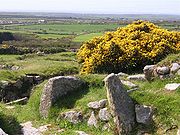
Carn Euny is best known for the well-preserved state of the large fogou
Fogou
A fogou or fougou is an underground, dry-stone structure found on Iron Age or Romano-British defended settlement sites in Cornwall. Fogous have similarities with souterrains or earth-houses of northern Europe and particularly Scotland including the Orkney Islands...
, an underground passageway, which is more than 65 feet (20 metres) long. This fogou runs just below the surface of the ground and is roofed with massive stone slabs. Although the exact purpose of these fogous is still a mystery, possibilities include storage, habitation, or ritual. The site was abandoned late in the Roman
Roman Britain
Roman Britain was the part of the island of Great Britain controlled by the Roman Empire from AD 43 until ca. AD 410.The Romans referred to the imperial province as Britannia, which eventually comprised all of the island of Great Britain south of the fluid frontier with Caledonia...
period.
Location

Cornwall
Cornwall is a unitary authority and ceremonial county of England, within the United Kingdom. It is bordered to the north and west by the Celtic Sea, to the south by the English Channel, and to the east by the county of Devon, over the River Tamar. Cornwall has a population of , and covers an area of...
in the Penwith
Penwith
Penwith was a local government district in Cornwall, England, United Kingdom, whose council was based in Penzance. The district covered all of the Penwith peninsula, the toe-like promontory of land at the western end of Cornwall and which included an area of land to the east that fell outside the...
District, near the village of Sancreed
Sancreed
Sancreed is a village and civil parish in Cornwall, United Kingdom. The village is situated approximately three miles from Penzance....
. The archaeological site can be accessed at any time and the admission is free. Parking can be found in the nearby hamlet of Brane. Another Iron Age settlement is the nearby Chysauster
Chysauster Ancient Village
Chysauster Ancient Village is a late Iron Age and Romano-British village of courtyard houses in Cornwall, England, United Kingdom, which is currently in the care of English Heritage...
. Carn Euny is managed by the Cornwall Heritage Trust on behalf of English Heritage
English Heritage
English Heritage . is an executive non-departmental public body of the British Government sponsored by the Department for Culture, Media and Sport...
.
Construction
Traces of human activity in Carn Euny have been detected from the early NeolithicNeolithic
The Neolithic Age, Era, or Period, or New Stone Age, was a period in the development of human technology, beginning about 9500 BC in some parts of the Middle East, and later in other parts of the world. It is traditionally considered as the last part of the Stone Age...
period. The first settlement of wooden huts was around 200 BC. In the 1st century BC these were replaced by stone huts, the remains of which are still visible. At this time, the people of Carn Euny lived from agriculture
Agriculture
Agriculture is the cultivation of animals, plants, fungi and other life forms for food, fiber, and other products used to sustain life. Agriculture was the key implement in the rise of sedentary human civilization, whereby farming of domesticated species created food surpluses that nurtured the...
, livestock
Livestock
Livestock refers to one or more domesticated animals raised in an agricultural setting to produce commodities such as food, fiber and labor. The term "livestock" as used in this article does not include poultry or farmed fish; however the inclusion of these, especially poultry, within the meaning...
, trade
Trade
Trade is the transfer of ownership of goods and services from one person or entity to another. Trade is sometimes loosely called commerce or financial transaction or barter. A network that allows trade is called a market. The original form of trade was barter, the direct exchange of goods and...
, and perhaps tin mining
Tin mining in Britain
Tin mining in Britain took place from prehistoric times until the 20th century. Mention of tin mining in Britain was made by many Classical writers. As South-West Britain was one of the few parts of England to escape glaciation, tin ore was readily available on the surface...
. The houses were of a type with enclosed courtyards. The most important structure of the site is certainly the fogou
Fogou
A fogou or fougou is an underground, dry-stone structure found on Iron Age or Romano-British defended settlement sites in Cornwall. Fogous have similarities with souterrains or earth-houses of northern Europe and particularly Scotland including the Orkney Islands...
(Cornish
Cornish language
Cornish is a Brythonic Celtic language and a recognised minority language of the United Kingdom. Along with Welsh and Breton, it is directly descended from the ancient British language spoken throughout much of Britain before the English language came to dominate...
for cave), a man-made underground passage which is covered with massive stone slabs. Fogous can be found in other places in the UK and Ireland, and are known more generally as souterrain
Souterrain
Souterrain is a name given by archaeologists to a type of underground structure associated mainly with the Atlantic Iron Age. These structures appear to have been brought northwards from Gaul during the late Iron Age. Regional names include earth houses, fogous and Pictish houses...
s. Their purpose is unclear. The fogou of Carn Euny is in particularly good condition and consists of a 20 m long corridor, with a side passage that leads to a round stone chamber with a collapsed roof, and a small tunnel which may be a second entrance.
Excavations
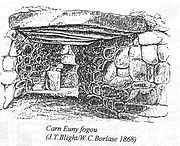
William Copeland Borlase
William Copeland Borlase FSA was an antiquarian and Liberal politician who sat in the House of Commons from 1880 until 1887 when he was ruined by bankruptcy and scandal....
examined the archaeological site and exposed the fogou. The graphic artist John Thomas Blight
John Thomas Blight
John Thomas Blight FSA was a Cornish archaeological artist born near Redruth in Cornwall.His father, Robert, a teacher, moved the family to Penzance and introduced his sons to the study of nature, antiquities and folk lore. John Blight was a natural draughtsman...
made corresponding engravings for the excavation report. During the 1920s Dr. Favell and Canon Taylor discovered the foundation walls of the houses with courtyards. Between 1964 and 1972 extensive excavations were carried out, in which nine hut foundations were discovered. The fogou and the circular chamber were investigated and restored. Four main occupation phases between the 5th Century BC and the 4th Century AD were found.
Chapel Euny Well
West of the settlement are a pair of ancient wells. One is mentioned in The Legendary Lore of the Holy Wells of England of 1893 where William BorlaseWilliam Borlase
William Borlase , Cornish antiquary, geologist and naturalist, was born at Pendeen in Cornwall, of an ancient family . From 1722 he was Rector of Ludgvan and died there in 1772.-Life and works:...
states (writing in the 1750s):
"I happened luckily to be at this well upon the last day of the year, on which, according to vulgar opinion, it exerts its principal and most salutary powers. Two women were here, who came from a neighbouring parish, and were busily employed in bathing a child. They both assured me that people who had a mind to receive any benefit from St. Euny's Well must come and wash upon the three first Wednesdays in May. Children suffering from mesenteric disease should be dipped three times in Chapel Uny widderschynnesIt is also referred to as St. Eurinus' or Uny's Well and may be confused with Saint Euny's Well at Carn BreaWiddershinsWiddershins means to take a course opposite the apparent motion of the sun, to go counterclockwise or lefthandwise, or to circle an object by always keeping it on the left...
, and widderschynnes dragged three times round the well."
Carn Brea
Carn Brea is a civil parish and hilltop site in Cornwall, United Kingdom. The hilltop site is situated approximately one mile southwest of Redruth.-Neolithic settlement:...
.