
Candlewood Lake
Encyclopedia
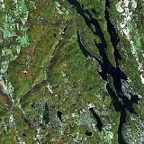
Candlewood Lake, 8.4 sq mi (21.8 km²), is located in Fairfield
and Litchfield
counties of western Connecticut
, in the northeastern United States
. It is the largest lake in Connecticut. The lake is bordered by five towns: Brookfield
, Danbury
, New Fairfield
, New Milford
, and Sherman
.
dam
south of the Rocky River
's junction with the Housatonic River
. Similar to a giant battery, its main purpose is to store water during periods of low electrical demand for power generation when demand is high. Excess electricity from the valley's hydro-system is used to pump water up a hillside into the lake from the nearby Housatonic River during spring, and overnight hours in summer. The water is then allowed to flow back down into the river when extra electricity is needed in the grid, often during the region's mid-to-late summer heat waves. Power is generated by turbines that are spun by the water flowing into the river while pumping is done by reversing the impellers.
Candlewood Lake was created in the 1920s. Inhabitants were relocated, but many of the buildings were left standing and some farming equipment was left behind. The roads were not torn up before the valley was flooded. Scuba divers can investigate buildings from that era, following the roads underwater, and discover artifacts from that era. Some of the notable underwater finds are model Ts, plane wreckage from small craft that have hit the lake since then, and covered bridges from that era.
The lake is around 40 feet (12.2 m) deep in most places, with some deeper areas that are 80 feet (24.4 m). There is a 45 mi/h daytime speed limit for boats and a 25 mi/h nighttime speed limit from 1/2 hour after sunset to 1/2 hour before sunrise. A 6 mi/h speed limit is in effect within 100 feet of shore, dock, moored vessels, and other places that the power company has marked as hazardous.
and Eurasian milfoil
in shallower areas. Because of the silt kicked up by boats and the problem with water weeds and algae, the visibility in the lake is from 5 to 20 feet (6.1 m).
The level of the lake usually is lowered by 10 feet (3 m) over the winter in an attempt to freeze weeds. Attempts have been made to trim them with mechanical cutters on barges; this has had limited success. In December 2006, the Connecticut Department of Environmental Protection
, working with members of the U.S. Environmental Protection Agency treated Candlewood Lake for its eelgrass and algae issues with an organic phosphate; the initial results appeared promising. However, the full effect of the treatment, and subsequent additional treatments will not be realized for several more years.
Within weeks, an army of 50 surveyors swarmed into the valley, and lawyers were hired to process the deeds transferring land held by some families since before the American Revolution into the hands of CL&P. The utility had the power of eminent domain and so the farmers sold their land -- $2,356 for 53 acres (214,483.6 m²), $3,000 for 34 acres (137,593.2 m²), $100 for 3 acres (12,140.6 m²).
Starting in late July 1926, nearly 1400 men labored to create Connecticut's largest body of water. About 500 men from Maine and Canada hand-felled 4500 acres (18.2 km²) of woodland, burning the lumber in massive bonfires - reminiscent of Indian campfires that once burned in the valley centuries earlier. Several dams were built. The largest, at the north end of the valley, measured 952 feet (290.2 m) wide and 100 feet (30.5 m) high upon completion.
On February 25, 1928, the first pumping operation began pouring water into the valley from the Housatonic. Engineers had planned on the Rocky River and its tributaries filling the valley one-fourth of the way, with the generating plant pumping the remaining three-fourths of the water out of the Housatonic. The valley filled quickly; on September 29, 1928, the water reached an elevation of 429 feet (130.8 m) above sea level, and Candlewood Lake was considered complete.
Even before the lake's filling was completed, it became apparent it would draw summer vacationers from as far away as New York City. Land prices on what would become the shoreline had already jumped to $1,000 an acre; summer developments sprang up almost immediately.
Although it was almost called Lake Danbury, the new body of water ultimately got its name from New Milford's Candlewood Mountain - which was named after the Candlewood tree, whose sapling branches were sometimes used as candles by early settlers.
To this day Candlewood Lake serves as a relaxing getaway for city folk and a year-round home for others. Common activities for lake-goers include swimming and boating. Candlewood Lake is also home to "Chicken Rock", which is a large rock from which people jump into the water.

Fairfield County, Connecticut
Fairfield County is a county located in the southwestern corner of the U.S. state of Connecticut. The county population is 916,829 according to the 2010 Census. There are currently 1,465 people per square mile in the county. It is the most populous county in the State of Connecticut and contains...
and Litchfield
Litchfield County, Connecticut
Litchfield County is a county located in the northwestern corner of the U.S. state of Connecticut. Litchfield County has the lowest population density of any county in Connecticut but is geographically the state's largest county. As of 2010 the population was 189,927...
counties of western Connecticut
Connecticut
Connecticut is a state in the New England region of the northeastern United States. It is bordered by Rhode Island to the east, Massachusetts to the north, and the state of New York to the west and the south .Connecticut is named for the Connecticut River, the major U.S. river that approximately...
, in the northeastern United States
United States
The United States of America is a federal constitutional republic comprising fifty states and a federal district...
. It is the largest lake in Connecticut. The lake is bordered by five towns: Brookfield
Brookfield, Connecticut
Brookfield is a town located in northern Fairfield County, Connecticut, United States. The population was 16,452 at the 2010 census. First settled in 1710 by John Muirwood and several other colonial founders who bartered for the land From the Wyantenuck Nation Under the Sachem Waramaugs who lived...
, Danbury
Danbury, Connecticut
Danbury is a city in northern Fairfield County, Connecticut, United States. It had population at the 2010 census of 80,893. Danbury is the fourth largest city in Fairfield County and is the seventh largest city in Connecticut....
, New Fairfield
New Fairfield, Connecticut
New Fairfield is a town in Fairfield County, Connecticut, United States. The population was 13,881 at the 2010 census. The town is considered part of the greater New York Metropolitan Area and lies approximately from New York City...
, New Milford
New Milford, Connecticut
New Milford is a town in southern Litchfield County, Connecticut, United States north of Danbury, on the Housatonic River. It is the largest town in the state in terms of land area at nearly . The population was 28,671 according to the Census Bureau's 2006 estimates...
, and Sherman
Sherman, Connecticut
Sherman is the northernmost and least populous town of Fairfield County, Connecticut, United States. The population was 3,581 at the 2010 census. The town is named for New Haven's Founding Father, Roger Sherman....
.
Hydroelectric dam
Candlewood Lake was formed behind a hydroelectricHydroelectricity
Hydroelectricity is the term referring to electricity generated by hydropower; the production of electrical power through the use of the gravitational force of falling or flowing water. It is the most widely used form of renewable energy...
dam
Dam
A dam is a barrier that impounds water or underground streams. Dams generally serve the primary purpose of retaining water, while other structures such as floodgates or levees are used to manage or prevent water flow into specific land regions. Hydropower and pumped-storage hydroelectricity are...
south of the Rocky River
Rocky River (Connecticut)
The Rocky River is very short and small tributary of the Housatonic River in the U.S. state of Connecticut. It flows into the Housatonic River from the west just upstream from New Milford at...
's junction with the Housatonic River
Housatonic River
The Housatonic River is a river, approximately long, in western Massachusetts and western Connecticut in the United States. It flows south to southeast, and drains about of southwestern New England into Long Island Sound...
. Similar to a giant battery, its main purpose is to store water during periods of low electrical demand for power generation when demand is high. Excess electricity from the valley's hydro-system is used to pump water up a hillside into the lake from the nearby Housatonic River during spring, and overnight hours in summer. The water is then allowed to flow back down into the river when extra electricity is needed in the grid, often during the region's mid-to-late summer heat waves. Power is generated by turbines that are spun by the water flowing into the river while pumping is done by reversing the impellers.
Candlewood Lake was created in the 1920s. Inhabitants were relocated, but many of the buildings were left standing and some farming equipment was left behind. The roads were not torn up before the valley was flooded. Scuba divers can investigate buildings from that era, following the roads underwater, and discover artifacts from that era. Some of the notable underwater finds are model Ts, plane wreckage from small craft that have hit the lake since then, and covered bridges from that era.
Popular recreation area
The lake is used year-round, although tourists primarily come during the summer months for fishing, boating, and golfing. Along its approximately 60-mile (97 km) shoreline are five-star tourist resorts and recreational facilities, including golf courses, beaches, and marinas.The lake is around 40 feet (12.2 m) deep in most places, with some deeper areas that are 80 feet (24.4 m). There is a 45 mi/h daytime speed limit for boats and a 25 mi/h nighttime speed limit from 1/2 hour after sunset to 1/2 hour before sunrise. A 6 mi/h speed limit is in effect within 100 feet of shore, dock, moored vessels, and other places that the power company has marked as hazardous.
Environmental problems
The lake has an ongoing problem with the growth of eelgrassVallisneria
Vallisneria is a genus of freshwater aquatic plant, commonly called eelgrass, tape grass or vallis. The genus has 6-10 species that are widely distributed, but do not grow in colder regions....
and Eurasian milfoil
Myriophyllum
Myriophyllum is a genus of about 69 species of freshwater aquatic plants, with a cosmopolitan distribution. The center of diversity for Myriophyllum is Australia with 43 recognized species...
in shallower areas. Because of the silt kicked up by boats and the problem with water weeds and algae, the visibility in the lake is from 5 to 20 feet (6.1 m).
The level of the lake usually is lowered by 10 feet (3 m) over the winter in an attempt to freeze weeds. Attempts have been made to trim them with mechanical cutters on barges; this has had limited success. In December 2006, the Connecticut Department of Environmental Protection
Connecticut Department of Environmental Protection
The Connecticut Department of Energy and Environmental Protection is a state agency of Connecticut. The department oversees the natural resources and environment of the state, as well as regulating public utilities and energy policy...
, working with members of the U.S. Environmental Protection Agency treated Candlewood Lake for its eelgrass and algae issues with an organic phosphate; the initial results appeared promising. However, the full effect of the treatment, and subsequent additional treatments will not be realized for several more years.
History
On July 15, 1926, Connecticut Light and Power Company's board of directors approved a plan that would be unique: the first large-scale operation of pumped storage facilities in the US. By creating the lake and pumping it full of water from the Housatonic River, then letting the water pour down an immense pipe, called a penstock, and into a turbine, the utility could produce electricity.Within weeks, an army of 50 surveyors swarmed into the valley, and lawyers were hired to process the deeds transferring land held by some families since before the American Revolution into the hands of CL&P. The utility had the power of eminent domain and so the farmers sold their land -- $2,356 for 53 acres (214,483.6 m²), $3,000 for 34 acres (137,593.2 m²), $100 for 3 acres (12,140.6 m²).
Starting in late July 1926, nearly 1400 men labored to create Connecticut's largest body of water. About 500 men from Maine and Canada hand-felled 4500 acres (18.2 km²) of woodland, burning the lumber in massive bonfires - reminiscent of Indian campfires that once burned in the valley centuries earlier. Several dams were built. The largest, at the north end of the valley, measured 952 feet (290.2 m) wide and 100 feet (30.5 m) high upon completion.
On February 25, 1928, the first pumping operation began pouring water into the valley from the Housatonic. Engineers had planned on the Rocky River and its tributaries filling the valley one-fourth of the way, with the generating plant pumping the remaining three-fourths of the water out of the Housatonic. The valley filled quickly; on September 29, 1928, the water reached an elevation of 429 feet (130.8 m) above sea level, and Candlewood Lake was considered complete.
Even before the lake's filling was completed, it became apparent it would draw summer vacationers from as far away as New York City. Land prices on what would become the shoreline had already jumped to $1,000 an acre; summer developments sprang up almost immediately.
Although it was almost called Lake Danbury, the new body of water ultimately got its name from New Milford's Candlewood Mountain - which was named after the Candlewood tree, whose sapling branches were sometimes used as candles by early settlers.
To this day Candlewood Lake serves as a relaxing getaway for city folk and a year-round home for others. Common activities for lake-goers include swimming and boating. Candlewood Lake is also home to "Chicken Rock", which is a large rock from which people jump into the water.
Recent events
On the morning of Saturday, July 19, 2008, two men were killed, and a local firefighter was critically injured when the 24 feet (7.3 m) power boat they were operating while they were intoxicated collided with an 18 feet (5.5 m) Triton fishing boat. Neither of the Triton's passengers sustained life-threatening injuries; however the passing of two local men and the injuries to the third left local government officials scrambling to examine existing regulations needed to enforce alcohol laws while boaters are on the lake.Islands
- Green Island
- Deer Island
- Cedar Island
- Oak Island
- Rock Island
- Pine Island
- Thistle Island