

Canals of Amsterdam
Encyclopedia
Amsterdam
, capital of the Netherlands, has been called the "Venice of the North
" for its more than one hundred kilometres of canal
s, about 90 island
s and 1,500 bridge
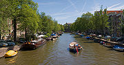
s. The three main canal
s, Herengracht, Prinsengracht, and Keizersgracht, dug in the 17th century during the Dutch Golden Age
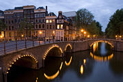
, form concentric belts around the city, known as the grachtengordel. Alongside the main canals are 1550 monumental buildings
. The 17th-century canal ring area, including the Prinsengracht, Keizersgracht, Herengracht and Jordaan, are put on the UNESCO World Heritage List.
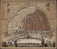 Much of the Amsterdam canal system is the successful outcome of city planning. In the early part of the 17th century, with immigration
at a height, a comprehensive plan was put together, calling for four main, concentric half-circles of canals with their ends resting on the IJ
bay. Known as the "grachtengordel", three of the canals are mostly for residential development (Herengracht or ‘’Patricians' Canal’’; Keizersgracht or ‘’Emperor's Canal’’; and Prinsengracht or ‘’Prince's Canal’’), and a fourth, outer canal, Singelgracht, for purposes of defense and water management. The plan also envisaged interconnecting canals along radii; a set of parallel canals in the Jordaan
quarter (primarily for the transportation of goods, for example, beer); the conversion of an existing, inner perimeter canal (Singel) from a defensive purpose to residential and commercial development; and more than one hundred bridges. The defensive purpose of the Nassau/Stadhouderskade was served by moat and earthen dikes
, with gates at transit points but otherwise no masonry superstructure
s.
Construction proceeded from west to east, across the breadth of the layout, like a gigantic windshield wiper as the historian Geert Mak
calls it – not from the center outwards as a popular myth has it. Construction of the north-western sector was started in 1613 and was finished around 1625. After 1664, building in the southern sector was started, although slowly because of an economic depression. The eastern part of the concentric canal plan, covering the area between the Amstel
river and the IJ bay, was not implemented for a long time. In the following centuries, the land went mostly for park, the Botanical garden, old age homes, theaters and other public facilities – and for waterways without much plan. Several parts of the city and of the urban area
are polder
s, recognisable by their postfix
-meer meaning 'lake', such as Aalsmeer
, Bijlmermeer
, Haarlemmermeer
, and Watergraafsmeer
.
around the city from 1480 until 1585, when Amsterdam expanded beyond Singel. The canal runs from the IJ
bay, near Central Station
, to the Muntplein
square, where it meets the Amstel
river. It is now the inner-most canal in Amsterdam's semicircular ring of canals. The canal should not be confused with Singelgracht canal, which became the outer limit of the city during the Dutch Golden Age
in the 17th Century.
who governed the city in the 16th and 17th century. The most fashionable part is called the Golden Bend, with many double wide mansions, inner gardens and coach houses on Keizersgracht.
 Keizersgracht (literal English
translation: Emperor's Canal) is the second and widest of the three major canals in the city centre of Amsterdam, in between Herengracht and Prinsengracht. It is named after Maximilian I, Holy Roman Emperor
.
 Prinsengracht (Prince's Canal) is the fourth and the longest of the main canals in Amsterdam. It is named after the Prince of Orange
. Most of the canal houses along it were built during the Dutch Golden Age
of the United Provinces
. The bridges over this canal don't connect with the streets in the Jordaan
.
Interesting sights along Prinsengracht include the Noorderkerk (Northern Church), the Noordermarkt
(Northern Market), Anne Frank House
, the Westerkerk
(Western Church, Amsterdam's tallest church) with the Homomonument
(Gay Monument), which actually faces Keizersgracht.
. The painter Rembrandt and philosopher Spinoza
lived here. In 2006 it was voted one of the most beautiful streets in Amsterdam by readers of Het Parool
, a local daily newspaper.
Zwanenburgwal flows from Sint Antoniessluis sluice gate (between the streets Sint Antoniesbreestraat
and Jodenbreestraat
) to the Amstel
river. The canal was originally named Verversgracht ("dyers' canal"), after the textile industry that once dominated this part of town. Dyed textiles were hung to dry along the canal.
and is part of the canal belt connecting the Singel, Herengracht, Keizergracht and Prinsengracht and marks the northern border of the canal belt. The canal served as a site for ships returning from Asia
with spices and silks, therefore Brouwersgracht had many warehouses and storage depots for the ships inventories. Breweries
were also prevalent in the area due to the access to fresh water shipments. Today the warehouses are now apartments, some of the most expensive in Amsterdam. Houseboats also are seen in the canal. Brouwersgracht was voted the most beautiful street in Amsterdam by readers of Het Parool
, a local daily newspaper.
to the Amstel
River on the edge of the medieval city. The east side became populated in the 17th century and has a few grand mansions, like the Trippenhuis, now housing the KNAW
. Kloveniersburgwal was popular with administrators at the Dutch East India Company
, being close to its nerve center on Oude Hoogstraat and its warehouse.
, north-east of the City Center. The canals are lined with modern interpretations of classic Amsterdam canal houses, which were designed by 19 young Dutch architects. Each house is 4.5 meters wide and 4 or 5 stories tall, but the designs are totally unique and are often featured in Amsterdam travel guides despite being off the beaten path of most tourists. Nine ornate metal bridges, designed by artist couple Guy Rombouts and Monika Droste, cross the canals for pedestrians and cyclists.
Amsterdam
Amsterdam is the largest city and the capital of the Netherlands. The current position of Amsterdam as capital city of the Kingdom of the Netherlands is governed by the constitution of August 24, 1815 and its successors. Amsterdam has a population of 783,364 within city limits, an urban population...
, capital of the Netherlands, has been called the "Venice of the North
Venice of the North
The term Venice of the North refers to various cities in northern Europe that contain canals, comparing them to Venice, Italy, which is renowned for its canals .* Saint Petersburg* Amsterdam* Bruges* Stockholm* Copenhagen* Hamburg...
" for its more than one hundred kilometres of canal
Canal
Canals are man-made channels for water. There are two types of canal:#Waterways: navigable transportation canals used for carrying ships and boats shipping goods and conveying people, further subdivided into two kinds:...
s, about 90 island
Island
An island or isle is any piece of sub-continental land that is surrounded by water. Very small islands such as emergent land features on atolls can be called islets, cays or keys. An island in a river or lake may be called an eyot , or holm...
s and 1,500 bridge
Bridge
A bridge is a structure built to span physical obstacles such as a body of water, valley, or road, for the purpose of providing passage over the obstacle...
s. The three main canal
Canal
Canals are man-made channels for water. There are two types of canal:#Waterways: navigable transportation canals used for carrying ships and boats shipping goods and conveying people, further subdivided into two kinds:...
s, Herengracht, Prinsengracht, and Keizersgracht, dug in the 17th century during the Dutch Golden Age
Dutch Golden Age
The Golden Age was a period in Dutch history, roughly spanning the 17th century, in which Dutch trade, science, military and art were among the most acclaimed in the world. The first half is characterised by the Eighty Years' War till 1648...
, form concentric belts around the city, known as the grachtengordel. Alongside the main canals are 1550 monumental buildings
Monument
A monument is a type of structure either explicitly created to commemorate a person or important event or which has become important to a social group as a part of their remembrance of historic times or cultural heritage, or simply as an example of historic architecture...
. The 17th-century canal ring area, including the Prinsengracht, Keizersgracht, Herengracht and Jordaan, are put on the UNESCO World Heritage List.
History
Immigration
Immigration is the act of foreigners passing or coming into a country for the purpose of permanent residence...
at a height, a comprehensive plan was put together, calling for four main, concentric half-circles of canals with their ends resting on the IJ
IJ (bay)
The IJ is a river, formerly a bay, in the Dutch province of North Holland. It is known for being Amsterdam's waterfront. The name derives from the generic Germanic term for "water" and is similar to other Aa/Ee names for bodies of water. In Dutch, the name consists of the digraph ij, which is...
bay. Known as the "grachtengordel", three of the canals are mostly for residential development (Herengracht or ‘’Patricians' Canal’’; Keizersgracht or ‘’Emperor's Canal’’; and Prinsengracht or ‘’Prince's Canal’’), and a fourth, outer canal, Singelgracht, for purposes of defense and water management. The plan also envisaged interconnecting canals along radii; a set of parallel canals in the Jordaan
Jordaan
The Jordaan is a district of the city of Amsterdam in the Netherlands. The area is bordered by the Lijnbaansgracht canal to the west, the Prinsengracht to the east, the Brouwersgracht to the north and the Leidsegracht to the south...
quarter (primarily for the transportation of goods, for example, beer); the conversion of an existing, inner perimeter canal (Singel) from a defensive purpose to residential and commercial development; and more than one hundred bridges. The defensive purpose of the Nassau/Stadhouderskade was served by moat and earthen dikes
Earthworks (engineering)
Earthworks are engineering works created through the moving or processing of quantities of soil or unformed rock.- Civil engineering use :Typical earthworks include roads, railway beds, causeways, dams, levees, canals, and berms...
, with gates at transit points but otherwise no masonry superstructure
Superstructure
A superstructure is an upward extension of an existing structure above a baseline. This term is applied to various kinds of physical structures such as buildings, bridges, or ships...
s.
Construction proceeded from west to east, across the breadth of the layout, like a gigantic windshield wiper as the historian Geert Mak
Geert Mak
Geert Mak is a Dutch journalist and a non-fiction writer in the field of history. His ten books about Amsterdam, Netherlands and Europe have earned him great popularity. His best-known work, In Europe, a combination of a travelogue through the continent of Europe and a history of the 20th century,...
calls it – not from the center outwards as a popular myth has it. Construction of the north-western sector was started in 1613 and was finished around 1625. After 1664, building in the southern sector was started, although slowly because of an economic depression. The eastern part of the concentric canal plan, covering the area between the Amstel
Amstel
The Amstel is a river in the Netherlands which runs through the city of Amsterdam. The river's name is derived from Aeme stelle, old Dutch for "area abounding with water"....
river and the IJ bay, was not implemented for a long time. In the following centuries, the land went mostly for park, the Botanical garden, old age homes, theaters and other public facilities – and for waterways without much plan. Several parts of the city and of the urban area
Urban area
An urban area is characterized by higher population density and vast human features in comparison to areas surrounding it. Urban areas may be cities, towns or conurbations, but the term is not commonly extended to rural settlements such as villages and hamlets.Urban areas are created and further...
are polder
Polder
A polder is a low-lying tract of land enclosed by embankments known as dikes, that forms an artificial hydrological entity, meaning it has no connection with outside water other than through manually-operated devices...
s, recognisable by their postfix
Suffix
In linguistics, a suffix is an affix which is placed after the stem of a word. Common examples are case endings, which indicate the grammatical case of nouns or adjectives, and verb endings, which form the conjugation of verbs...
-meer meaning 'lake', such as Aalsmeer
Aalsmeer
Aalsmeer is a municipality and a town in the Netherlands, in the province of North Holland. Its name is derived from the Dutch for eel and lake . Aalsmeer is bordered by the Westeinderplassen lake, the largest open water of the Randstad, and the Ringvaart Canal...
, Bijlmermeer
Bijlmermeer
The Bijlmermeer or colloquially Bijlmer is one of the neighbourhoods that form the Amsterdam Zuidoost borough of Amsterdam, Netherlands. To many people, the Bijlmer designation is used to refer to Amsterdam Zuidoost and Diemen Zuid as a pars pro toto...
, Haarlemmermeer
Haarlemmermeer
Haarlemmermeer is a municipality in the Netherlands, in the province of North Holland. It is a polder, consisting of land reclaimed from water, and the name Haarlemmermeer means Haarlem's Lake, still referring to the body of water from which the region was reclaimed in the 19th century.Its main...
, and Watergraafsmeer
Watergraafsmeer
The Watergraafsmeer is a polder in The Netherlands. It was reclaimed in 1629. In the 17th and 18th centuries, there were many buitenplaatsen in the Watergraafsmeer, though nowadays only one, Frankendael, remains....
.
Singel
Singel encircled the medieval city of Amsterdam. It served as a moatMoat
A moat is a deep, broad ditch, either dry or filled with water, that surrounds a castle, other building or town, historically to provide it with a preliminary line of defence. In some places moats evolved into more extensive water defences, including natural or artificial lakes, dams and sluices...
around the city from 1480 until 1585, when Amsterdam expanded beyond Singel. The canal runs from the IJ
IJ (bay)
The IJ is a river, formerly a bay, in the Dutch province of North Holland. It is known for being Amsterdam's waterfront. The name derives from the generic Germanic term for "water" and is similar to other Aa/Ee names for bodies of water. In Dutch, the name consists of the digraph ij, which is...
bay, near Central Station
Amsterdam Centraal
' is the central station of Amsterdam. It is one of the main railway hubs of the Netherlands and is used by 250,000 passengers a day, excluding transferring passengers. It is also the starting point of Amsterdam Metro lines 51, 53, and 54. The station building of Amsterdam Centraal was designed by...
, to the Muntplein
Muntplein (Amsterdam)
The Muntplein is a square in the centre of Amsterdam. The square is in fact a bridge — the widest bridge in Amsterdam — which crosses the Singel canal at the point where it flows into the Amstel river...
square, where it meets the Amstel
Amstel
The Amstel is a river in the Netherlands which runs through the city of Amsterdam. The river's name is derived from Aeme stelle, old Dutch for "area abounding with water"....
river. It is now the inner-most canal in Amsterdam's semicircular ring of canals. The canal should not be confused with Singelgracht canal, which became the outer limit of the city during the Dutch Golden Age
Dutch Golden Age
The Golden Age was a period in Dutch history, roughly spanning the 17th century, in which Dutch trade, science, military and art were among the most acclaimed in the world. The first half is characterised by the Eighty Years' War till 1648...
in the 17th Century.
Herengracht
Herengracht (Patricians' Canal or Lord's Canal) is the first of the three major canals in the city centre of Amsterdam. The canal is named after the heren regeerdersRegenten
In the 16th, 17th and 18th centuries, the regenten were the rulers of the Dutch Republic, the leaders of the Dutch cities or the heads of organisations . Though not formally a hereditary "class", they were de facto "patricians", comparable to that ancient Roman class...
who governed the city in the 16th and 17th century. The most fashionable part is called the Golden Bend, with many double wide mansions, inner gardens and coach houses on Keizersgracht.
Keizersgracht
English language
English is a West Germanic language that arose in the Anglo-Saxon kingdoms of England and spread into what was to become south-east Scotland under the influence of the Anglian medieval kingdom of Northumbria...
translation: Emperor's Canal) is the second and widest of the three major canals in the city centre of Amsterdam, in between Herengracht and Prinsengracht. It is named after Maximilian I, Holy Roman Emperor
Maximilian I, Holy Roman Emperor
Maximilian I , the son of Frederick III, Holy Roman Emperor and Eleanor of Portugal, was King of the Romans from 1486 and Holy Roman Emperor from 1493 until his death, though he was never in fact crowned by the Pope, the journey to Rome always being too risky...
.
Prinsengracht
William the Silent
William I, Prince of Orange , also widely known as William the Silent , or simply William of Orange , was the main leader of the Dutch revolt against the Spanish that set off the Eighty Years' War and resulted in the formal independence of the United Provinces in 1648. He was born in the House of...
. Most of the canal houses along it were built during the Dutch Golden Age
Dutch Golden Age
The Golden Age was a period in Dutch history, roughly spanning the 17th century, in which Dutch trade, science, military and art were among the most acclaimed in the world. The first half is characterised by the Eighty Years' War till 1648...
of the United Provinces
Dutch Republic
The Dutch Republic — officially known as the Republic of the Seven United Netherlands , the Republic of the United Netherlands, or the Republic of the Seven United Provinces — was a republic in Europe existing from 1581 to 1795, preceding the Batavian Republic and ultimately...
. The bridges over this canal don't connect with the streets in the Jordaan
Jordaan
The Jordaan is a district of the city of Amsterdam in the Netherlands. The area is bordered by the Lijnbaansgracht canal to the west, the Prinsengracht to the east, the Brouwersgracht to the north and the Leidsegracht to the south...
.
Interesting sights along Prinsengracht include the Noorderkerk (Northern Church), the Noordermarkt
Noordermarkt
The Noordermarkt is a square in the Jordaan neighborhood of Amsterdam, The Netherlands.The square is lined by cafés and restaurants. Markets are held on the square every Monday. On Saturdays, a popular organic farmer's market is held on the square...
(Northern Market), Anne Frank House
Anne Frank House
The Anne Frank House on Prinsengracht canal in Amsterdam, the Netherlands, is a museum dedicated to Jewish wartime diarist Anne Frank, who hid from Nazi persecution with her family and four other people in hidden rooms at the rear of the building...
, the Westerkerk
Westerkerk
The Westerkerk is a church of the Protestant Church in the Netherlands denomination in Amsterdam, built in 1620-1631 after a design by Hendrick de Keyser. It is next to Amsterdam's Jordaan district, on the bank of the Prinsengracht canal....
(Western Church, Amsterdam's tallest church) with the Homomonument
Homomonument
The Homomonument is a memorial in the centre of Amsterdam, the capital of the Netherlands. It commemorates all gay men and lesbians who have been subjected to persecution because of their homosexuality...
(Gay Monument), which actually faces Keizersgracht.
Zwanenburgwal
Zwanenburgwal is a canal and street in the center of AmsterdamAmsterdam
Amsterdam is the largest city and the capital of the Netherlands. The current position of Amsterdam as capital city of the Kingdom of the Netherlands is governed by the constitution of August 24, 1815 and its successors. Amsterdam has a population of 783,364 within city limits, an urban population...
. The painter Rembrandt and philosopher Spinoza
Baruch Spinoza
Baruch de Spinoza and later Benedict de Spinoza was a Dutch Jewish philosopher. Revealing considerable scientific aptitude, the breadth and importance of Spinoza's work was not fully realized until years after his death...
lived here. In 2006 it was voted one of the most beautiful streets in Amsterdam by readers of Het Parool
Het Parool
Het Parool is an Amsterdam-based daily newspaper. It was founded as a resistance paper during World War II by Frans Van Heuven Goedhart and Jaap Nunes Vaz...
, a local daily newspaper.
Zwanenburgwal flows from Sint Antoniessluis sluice gate (between the streets Sint Antoniesbreestraat
Sint Antoniesbreestraat
The Sint Antoniesbreestraat is a street in the centre of Amsterdam, The Netherlands. The street runs south from Nieuwmarkt square to the Sint Antoniesluis sluice gates....
and Jodenbreestraat
Jodenbreestraat
The Jodenbreestraat is a street in the centre of Amsterdam, The Netherlands. The street runs from the Sint Antoniesluis sluice gates to the Mr. Visserplein traffic circle...
) to the Amstel
Amstel
The Amstel is a river in the Netherlands which runs through the city of Amsterdam. The river's name is derived from Aeme stelle, old Dutch for "area abounding with water"....
river. The canal was originally named Verversgracht ("dyers' canal"), after the textile industry that once dominated this part of town. Dyed textiles were hung to dry along the canal.
Brouwersgracht
Brouwersgracht is a canal in the city centre of AmsterdamAmsterdam
Amsterdam is the largest city and the capital of the Netherlands. The current position of Amsterdam as capital city of the Kingdom of the Netherlands is governed by the constitution of August 24, 1815 and its successors. Amsterdam has a population of 783,364 within city limits, an urban population...
and is part of the canal belt connecting the Singel, Herengracht, Keizergracht and Prinsengracht and marks the northern border of the canal belt. The canal served as a site for ships returning from Asia
Asia
Asia is the world's largest and most populous continent, located primarily in the eastern and northern hemispheres. It covers 8.7% of the Earth's total surface area and with approximately 3.879 billion people, it hosts 60% of the world's current human population...
with spices and silks, therefore Brouwersgracht had many warehouses and storage depots for the ships inventories. Breweries
Brewery
A brewery is a dedicated building for the making of beer, though beer can be made at home, and has been for much of beer's history. A company which makes beer is called either a brewery or a brewing company....
were also prevalent in the area due to the access to fresh water shipments. Today the warehouses are now apartments, some of the most expensive in Amsterdam. Houseboats also are seen in the canal. Brouwersgracht was voted the most beautiful street in Amsterdam by readers of Het Parool
Het Parool
Het Parool is an Amsterdam-based daily newspaper. It was founded as a resistance paper during World War II by Frans Van Heuven Goedhart and Jaap Nunes Vaz...
, a local daily newspaper.
Kloveniersburgwal
Kloveniersburgwal is a canal running south from NieuwmarktNieuwmarkt
Nieuwmarkt is a square in the centre of the Dutch capital Amsterdam. The surrounding area is known as the Nieuwmarktbuurt ....
to the Amstel
Amstel
The Amstel is a river in the Netherlands which runs through the city of Amsterdam. The river's name is derived from Aeme stelle, old Dutch for "area abounding with water"....
River on the edge of the medieval city. The east side became populated in the 17th century and has a few grand mansions, like the Trippenhuis, now housing the KNAW
Royal Netherlands Academy of Arts and Sciences
The Royal Netherlands Academy of Arts and Sciences is an organisation dedicated to the advancement of science and literature in the Netherlands...
. Kloveniersburgwal was popular with administrators at the Dutch East India Company
Dutch East India Company
The Dutch East India Company was a chartered company established in 1602, when the States-General of the Netherlands granted it a 21-year monopoly to carry out colonial activities in Asia...
, being close to its nerve center on Oude Hoogstraat and its warehouse.
Brantasgracht, Lamonggracht, Majanggracht and Seranggracht
These four canals are the newest in Amsterdam, constructed on Java Island in 1995, a manmade island in the IJ HarborIJ (bay)
The IJ is a river, formerly a bay, in the Dutch province of North Holland. It is known for being Amsterdam's waterfront. The name derives from the generic Germanic term for "water" and is similar to other Aa/Ee names for bodies of water. In Dutch, the name consists of the digraph ij, which is...
, north-east of the City Center. The canals are lined with modern interpretations of classic Amsterdam canal houses, which were designed by 19 young Dutch architects. Each house is 4.5 meters wide and 4 or 5 stories tall, but the designs are totally unique and are often featured in Amsterdam travel guides despite being off the beaten path of most tourists. Nine ornate metal bridges, designed by artist couple Guy Rombouts and Monika Droste, cross the canals for pedestrians and cyclists.
Trivia
- In Dutch political debates, the Amsterdam grachtengordel (concentric ring of canals) is often raised as a symbol of pretentious intellectualism.
- Since the construction of the canals, there have been plans to connect the north of Amsterdam (Amsterdam-NoordAmsterdam-NoordAmsterdam-Noord is an autonomous stadsdeel of Amsterdam. The area is located north of the IJ, the body of water which separates it from central Amsterdam and the rest of the city.-Transport:...
) to the city center. In 1999, a plan was made to complete the existing canal circle in the North. Plans to gentrify this area are still under development, but the plan to complete the canals in the north has not yet been incorporated.