

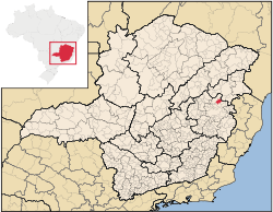
Campanário, Minas Gerais
Encyclopedia
Minas Gerais
Minas Gerais is one of the 26 states of Brazil, of which it is the second most populous, the third richest, and the fourth largest in area. Minas Gerais is the Brazilian state with the largest number of Presidents of Brazil, the current one, Dilma Rousseff, being one of them. The capital is the...
. Its population as of 2007 was 3,592 people living in a total area of 441 km². The city belongs to the meso-region of Vale do Rio Doce and to the micro-region of Governador Valadares
Governador Valadares
Governador Valadares is a Brazilian city in the state of Minas Gerais. In 2006, its population was 260,405 inhabitants.It is an economical center of the middle Valley of the Rio Doce, making a significant influence on the east and northeast of Minas Gerais and local authorities of the state of the...
. It became a municipality in 1943.
Location
The city center of Campanário is located at an elevation of 268 meters on the important federal highway BR-116 between Governador ValadaresGovernador Valadares
Governador Valadares is a Brazilian city in the state of Minas Gerais. In 2006, its population was 260,405 inhabitants.It is an economical center of the middle Valley of the Rio Doce, making a significant influence on the east and northeast of Minas Gerais and local authorities of the state of the...
and Teófilo Otoni
Teófilo Otoni
Téofilo Otoni is a city in northeast Minas Gerais state, Brazil. The population of the municipality was 126,895 in 2007 and the area is 3,253.4 km².-Origin of the name:...
. Neighboring municipalities are: Itambacuri
Itambacuri
Itambacuri is a Brazilian city located in the state of Minas Gerais. As of 2004 its population is estimated to be 23,424. Itambacuri contains its own airport, referred to as the 'Itambacuri airport'.-References:...
(W and N), Frei Gaspar
Frei Gaspar
Frei Gaspar is a Brazilian municipality located in the northeast of the state of Minas Gerais. Its population as of 2007 was estimated to be 6,343 people living in a total area of 628 km². The city belongs to the mesoregion of Vale do Mucuri and to the microregion of Teófilo Otoni. It became a...
(NE), Pescador
Pescador
Pescador is a town and municipality in the state of Minas Gerais in the Southeast region of Brazil.-References:...
(E), Jampruca
Jampruca
Jampruca is a town and municipality in the state of Minas Gerais in the Southeast region of Brazil.-References:...
(S).
Distances
- Belo HorizonteBelo HorizonteBelo Horizonte is the capital of and largest city in the state of Minas Gerais, located in the southeastern region of Brazil. It is the third largest metropolitan area in the country...
: 420 km (south on BR-116 to Governador Valadares, then southwest on BR-341) - Governador ValadaresGovernador ValadaresGovernador Valadares is a Brazilian city in the state of Minas Gerais. In 2006, its population was 260,405 inhabitants.It is an economical center of the middle Valley of the Rio Doce, making a significant influence on the east and northeast of Minas Gerais and local authorities of the state of the...
: 73 km south on BR-116 - Teófilo OtoniTeófilo OtoniTéofilo Otoni is a city in northeast Minas Gerais state, Brazil. The population of the municipality was 126,895 in 2007 and the area is 3,253.4 km².-Origin of the name:...
: 55 km north on BR-116 - ItambacuriItambacuriItambacuri is a Brazilian city located in the state of Minas Gerais. As of 2004 its population is estimated to be 23,424. Itambacuri contains its own airport, referred to as the 'Itambacuri airport'.-References:...
: 30 km north on BR-116 - PescadorPescadorPescador is a town and municipality in the state of Minas Gerais in the Southeast region of Brazil.-References:...
: 21 southeast on MG-311
Economic activities
Services and agriculture are the main economic activities. The GDP in 2005 was approximately R$15 million, with 9 million reais from services, 1 million reais from industry, and 4 million reais from agriculture. There were 190 rural producers on 19,000 hectares of land (2006). Approximately 450 persons were occupied in agriculture. The main crops are sugarcane, beans, and corn. There were 23,000 head of cattle, of which 3,700 were milk cows (2006). Only 25 of the rural properties had tractors in 2006.There were no banks (2007) In the vehicle fleet there were 161 automobiles, 10 trucks, 12 pickup trucks, 4 buses, and 70 motorcycles (2007).
Health and education
In the health sector there were 2 health clinics (2005). Educational needs of 1,100 students were met by 3 primary schools, 1 middle school, and 1 pre-primary school.- Municipal Human Development IndexHuman Development IndexThe Human Development Index is a composite statistic used to rank countries by level of "human development" and separate "very high human development", "high human development", "medium human development", and "low human development" countries...
: 0.668 (2000) - State ranking: 682 out of 853 municipalities as of 2000
- National ranking: 3,500 out of 5,138 municipalities as of 2000
- Literacy rate: 76%
- Life expectancy: 63 (average of males and females)
- Percentage of children under 5 years old in the population: 10.59 (all data below are from 2000)
- Percentage of adolescents in the population (10 to 19 years old): 22.32
- Percentage of old people in the population (60 years or more): 10.42
- Degree of urbanization: 70.96
- Percentage of urban homes connected to sewage system: 66.90
In 2000 the per capita monthly income of R$133.00 was below the state average of R$276.00 and below the national average of R$297.00. Poços de Caldas
Poços de Caldas
Poços de Caldas is a city and municipality in south-western Minas Gerais state, Brazil, in the microregion of the same name. Its estimated population in 2009 was 151,449 inhabitants...
had the highest per capita monthly income in 2000 with R$435.00. The lowest was Setubinha
Setubinha
Setubinha is a municipality in the northeast of the Brazilian state of Minas Gerais. As of 2007 the population was 10,834 in a total area of 536 km². The elevation is 729 metres. It is part of the IBGE statistical microregion of Teófilo Otoni...
with R$73.00.
The highest ranking municipality in Minas Gerais in 2000 was Poços de Caldas
Poços de Caldas
Poços de Caldas is a city and municipality in south-western Minas Gerais state, Brazil, in the microregion of the same name. Its estimated population in 2009 was 151,449 inhabitants...
with 0.841, while the lowest was Setubinha
Setubinha
Setubinha is a municipality in the northeast of the Brazilian state of Minas Gerais. As of 2007 the population was 10,834 in a total area of 536 km². The elevation is 729 metres. It is part of the IBGE statistical microregion of Teófilo Otoni...
with 0.568. Nationally the highest was São Caetano do Sul
São Caetano do Sul
São Caetano do Sul is a city in São Paulo state in Brazil, located in the Greater São Paulo Metropolitan Area. It is the city with the highest per capita income in Brazil and it also has the highest Human Development Index .-Geography:São Caetano do Sul is located on a plateau that is part of the...
in São Paulo with 0.919, while the lowest was Setubinha. In more recent statistics (considering 5,507 municipalities) Manari in the state of Pernambuco
Pernambuco
Pernambuco is a state of Brazil, located in the Northeast region of the country. To the north are the states of Paraíba and Ceará, to the west is Piauí, to the south are Alagoas and Bahia, and to the east is the Atlantic Ocean. There are about of beaches, some of the most beautiful in the...
has the lowest rating in the country—0,467—putting it in last place.
See also
- List of municipalities in Minas Gerais