
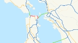
California State Route 480
Encyclopedia
State Route 480 was a state highway
in San Francisco, California
, United States
, consisting of the elevated double-decker Embarcadero Freeway (also known as the Embarcadero Skyway), the partly elevated Doyle Drive approach to the Golden Gate Bridge
and the proposed and unbuilt section in between. The unbuilt section from Doyle Drive to Van Ness Ave. was to have been called the Golden Gate Freeway and the Embarcadero Freeway as originally planned would have extended from Van Ness Ave. along the north side of Bay Street and then along the Embarcadero to the San Francisco-Oakland Bay Bridge
.
The Embarcadero Freeway, which had only been constructed from Broadway along the Embarcadero to the San Francisco Oakland Bay Bridge, was demolished after the 1989 Loma Prieta earthquake
, and Doyle Drive is now part of U.S. Route 101. SR 480 was Interstate 480, an auxiliary route of the Interstate Highway System
, from 1955 to 1965.
.svg.png)
 Legislative Route 224 was defined in 1947 to connect U.S. Route 101 (pre-1964 Legislative Route 2) at the intersection of Lombard Street
and Van Ness Avenue with U.S. Route 40 and U.S. Route 50 (pre-1964 Legislative Route 68) at the west end of the San Francisco – Oakland Bay Bridge (near the Transbay Terminal). Its alignment was roughly along Lombard Street and the Embarcadero.
Legislative Route 224, as well as Route 2 (US 101) from Route 224 west to the junction with State Route 1 near the Golden Gate Bridge
, was added to the Interstate Highway System
on September 15, 1955. This included the 1936 Doyle Drive, an early freeway built to access the Golden Gate Bridge
. After some discussion, the number Interstate 480 was assigned on November 10, 1958. (Interstate 280
, as originally planned, ran south from the west end of I-480 along SR 1, through the MacArthur Tunnel
and Golden Gate Park
, to join its present alignment in Daly City.)
In the original 1955 plan, it was planned to extend the Central Freeway
as a double decked structure between Van Ness Ave. and Polk Street north to Clay Street, then as a single deck depressed freeway north to Broadway, where it would have tunneled under Russian Hill to connect with Interstate 480.
The first section of the Embarcadero Freeway, from the Bay Bridge approach (Interstate 80) north to Broadway, opened in 1959. As a consequence of the freeway revolt
, the San Francisco Board of Supervisors
passed Resolution 45-59 in January 1959, opposing certain freeways including the remainder of I-480. The freeway revolt continued after a new freeway plan was proposed in 1964, with a major protest on May 17, 1964—200,000 people rallied in Golden Gate Park
against any more new freeways. Poet Kenneth Rexroth
spoke at the rally (among others) and folk singer Malvina Reynolds
sang (she was most famous for her song "Little Boxes
" attacking urban sprawl
, which she sang at the anti-freeway rally).
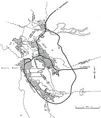
The proposed unbuilt section as replanned in 1964 would have extended not from from the Lombard St. exit of Doyle Drive along Lombard St. as originally planned in 1955, but from the Marina Blvd. exit of Doyle Drive, through the Marina Green
and then along the north side of Fort Mason
, then along the north side of Bay Street to the Embarcadero and south along the Embarcadero to connect with the former Embarcadero Freeway. The section between the Golden Gate Bridge (including an upgraded Doyle Drive) and Van Ness Ave. would have been named the Golden Gate Freeway; the rest of the freeway to the east of Van Ness Ave. would have been the extended originally planned full length of the Embarcadero Freeway, originally planned to extend from Van Ness Ave. to the San Francisco-Oakland Bay Bridge–going east first down the north side of Bay Street, then going southeast curving around the base of Telegraph Hill
and meeting at Broadway the former end of the actually constructed section of the Embarcadero Freeway.
In the 1964 renumbering
, Route 480 was designated for the full route of I-480, including the US 101 concurrency
. The route was deleted from the Interstate Highway System in January 1968, with Interstate 280
being rerouted north of Daly City at the same time. The short piece of former I-480 from the junction with new I-280 (previously State Route 87) south to the Bay Bridge approach became part of I-280 (to allow I-280 to meet I-80), now named the Southern Embarcadero Freeway. These changes were made to the state highway system in 1968; Route 480 was truncated only slightly, with the 5.47 miles (8.80 km) from I-280 to SR 1 remaining, though downgraded to State Route 480; this extension of I-280 south (the Junipero Serra Freeway) is considered the southern terminus of Junipero Serra Boulevard.
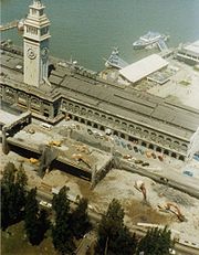 In the 1980s, opposition to the Embarcadero freeway resurfaced in proposals to tear down the freeway. On November 5, 1985, the San Francisco Board of Supervisors voted to tear down the Embarcadero Freeway. The proposal was put to the voters in 1987, and soundly defeated. The October 17, 1989 Loma Prieta earthquake significantly damaged the structure, causing it to be closed to traffic. CalTrans planned to retrofit and retain the two-decker freeway. Various groups in and outside the City supported the CalTrans plan, but there was a significant opinion within the City in favor of removing the freeway structure. Then Mayor Art Agnos proposed demolishing the freeway in favor of a boulevard with an underpass at the Ferry Building to allow for a large plaza.
Opposition to demolishing the freeway mounted again, with over 20,000 signatures gathered to again create a ballot measure. The strongest opposition came from Chinatown and other neighborhoods North of downtown. Merchants in Chinatown had suffered a dramatic decline in business in the months immediately following the earthquake and feared that if the freeway was not reopened they would not recover. Agnos continued to negotiate with federal and state officials to win enough funding to make the demolition practical, and the opposition quieted. Demolition began on February 27, 1991. That year Agnos was defeated for re-election as Chinatown switched its support away from him.
On June 16, 2006, the Port of San Francisco
unveiled a monument to Mayor Agnos honoring his vision and courage, noting: Legislative changes that year deleted Route 480 from the state highway system; the northwest section was transferred to U.S. Route 101. The only piece of the Embarcadero Freeway to remain was the beginning of the ramp from the Bay Bridge to Fremont Street, including a short ramp stub that formerly carried traffic to the freeway (Interstate 280
after 1968). This part was rebuilt as a part of the Bay Bridge retrofit project. (I-280 was never finished to that interchange
, though its legislative definition still takes it there.)
Prior to the earthquake, the Embarcadero Freeway carried approximately 70,000 vehicles daily in the vicinity of the Ferry Building. Another 40,000 vehicles/day used associated ramps at Main and Beale Sts.
In 2003, Caltrans began work on a retrofitting project to replace the western approach to the Bay Bridge. This retrofitting is part of a larger, $6 billion project to upgrade the aging Bay Bridge to modern earthquake standards, which includes replacing the entire eastern span. The entire project is scheduled to be complete in 2013, and the west approach was completed in 2009. In late 2005, Caltrans began the demolition of the original west approach after traffic was routed onto a temporary bypass structure. As a result of this retrofitting project, all old parts of the approach have been replaced, removing the final remains of the Embarcadero Freeway.
s, including Magnum Force
, Freebie and the Bean
, Bullitt
, Serial
, Superman IV: The Quest for Peace
, The Lineup
, Time After Time
, Innerspace
, and Koyaanisqatsi
. On television, the freeway was seen in such shows such as Full House
(in several overhead screen shots) and The Streets of San Francisco
. For a sequence at the beginning of the 2007 film Zodiac
, which takes place in the late 1960s and early '70s, the now-demolished freeway was digitally added behind a shot of the Ferry Building. In 1985, four years before its destruction, James Bond
(played for the last time by Roger Moore
) drove along the freeway in A View to a Kill
as he followed his ally Stacey Sutton
(Tanya Roberts
) during his quest to eliminate the villainous Max Zorin
(Christopher Walken
).
 The following is an exit list of the former Embarcadero Freeway prior to the Loma Prieta earthquake
and subsequent demolition.
The entire route was in San Francisco.
State highway
State highway, state road or state route can refer to one of three related concepts, two of them related to a state or provincial government in a country that is divided into states or provinces :#A...
in San Francisco, California
California
California is a state located on the West Coast of the United States. It is by far the most populous U.S. state, and the third-largest by land area...
, United States
United States
The United States of America is a federal constitutional republic comprising fifty states and a federal district...
, consisting of the elevated double-decker Embarcadero Freeway (also known as the Embarcadero Skyway), the partly elevated Doyle Drive approach to the Golden Gate Bridge
Golden Gate Bridge
The Golden Gate Bridge is a suspension bridge spanning the Golden Gate, the opening of the San Francisco Bay into the Pacific Ocean. As part of both U.S. Route 101 and California State Route 1, the structure links the city of San Francisco, on the northern tip of the San Francisco Peninsula, to...
and the proposed and unbuilt section in between. The unbuilt section from Doyle Drive to Van Ness Ave. was to have been called the Golden Gate Freeway and the Embarcadero Freeway as originally planned would have extended from Van Ness Ave. along the north side of Bay Street and then along the Embarcadero to the San Francisco-Oakland Bay Bridge
San Francisco-Oakland Bay Bridge
The San Francisco – Oakland Bay Bridge is a pair of bridges spanning San Francisco Bay of California, in the United States. Forming part of Interstate 80 and of the direct road route between San Francisco and Oakland, it carries approximately 270,000 vehicles per day on its two decks...
.
The Embarcadero Freeway, which had only been constructed from Broadway along the Embarcadero to the San Francisco Oakland Bay Bridge, was demolished after the 1989 Loma Prieta earthquake
Loma Prieta earthquake
The Loma Prieta earthquake, also known as the Quake of '89 and the World Series Earthquake, was a major earthquake that struck the San Francisco Bay Area of California on October 17, 1989, at 5:04 p.m. local time...
, and Doyle Drive is now part of U.S. Route 101. SR 480 was Interstate 480, an auxiliary route of the Interstate Highway System
Interstate Highway System
The Dwight D. Eisenhower National System of Interstate and Defense Highways, , is a network of limited-access roads including freeways, highways, and expressways forming part of the National Highway System of the United States of America...
, from 1955 to 1965.
History
Lombard Street (San Francisco)
Lombard Street is an east–west street in San Francisco, California. It is famous for having a steep, one-block section that consists of eight tight hairpin turns.-Route description:...
and Van Ness Avenue with U.S. Route 40 and U.S. Route 50 (pre-1964 Legislative Route 68) at the west end of the San Francisco – Oakland Bay Bridge (near the Transbay Terminal). Its alignment was roughly along Lombard Street and the Embarcadero.
Legislative Route 224, as well as Route 2 (US 101) from Route 224 west to the junction with State Route 1 near the Golden Gate Bridge
Golden Gate Bridge
The Golden Gate Bridge is a suspension bridge spanning the Golden Gate, the opening of the San Francisco Bay into the Pacific Ocean. As part of both U.S. Route 101 and California State Route 1, the structure links the city of San Francisco, on the northern tip of the San Francisco Peninsula, to...
, was added to the Interstate Highway System
Interstate Highway System
The Dwight D. Eisenhower National System of Interstate and Defense Highways, , is a network of limited-access roads including freeways, highways, and expressways forming part of the National Highway System of the United States of America...
on September 15, 1955. This included the 1936 Doyle Drive, an early freeway built to access the Golden Gate Bridge
Golden Gate Bridge
The Golden Gate Bridge is a suspension bridge spanning the Golden Gate, the opening of the San Francisco Bay into the Pacific Ocean. As part of both U.S. Route 101 and California State Route 1, the structure links the city of San Francisco, on the northern tip of the San Francisco Peninsula, to...
. After some discussion, the number Interstate 480 was assigned on November 10, 1958. (Interstate 280
Interstate 280 (California)
Interstate 280 is a 57-mile long north–south Interstate Highway in the San Francisco Bay Area of Northern California. It connects San Jose and San Francisco, running along just to the west of the cities of San Francisco Peninsula for most of its route.I-280 from its northern end at King...
, as originally planned, ran south from the west end of I-480 along SR 1, through the MacArthur Tunnel
MacArthur Tunnel
The MacArthur Tunnel, formally known as the General Douglas MacArthur Tunnel, is a highway tunnel located on the grounds of The Presidio of San Francisco in San Francisco, California...
and Golden Gate Park
Golden Gate Park
Golden Gate Park, located in San Francisco, California, is a large urban park consisting of of public grounds. Configured as a rectangle, it is similar in shape but 20% larger than Central Park in New York, to which it is often compared. It is over three miles long east to west, and about half a...
, to join its present alignment in Daly City.)
In the original 1955 plan, it was planned to extend the Central Freeway
Central Freeway
The Central Freeway is a roughly one-mile elevated freeway in San Francisco, California, United States, connecting the Bayshore/James Lick Freeway with the Hayes Valley neighborhood. Most of the freeway is part of US 101, which exits at Mission Street on the way to the Golden Gate Bridge...
as a double decked structure between Van Ness Ave. and Polk Street north to Clay Street, then as a single deck depressed freeway north to Broadway, where it would have tunneled under Russian Hill to connect with Interstate 480.
The first section of the Embarcadero Freeway, from the Bay Bridge approach (Interstate 80) north to Broadway, opened in 1959. As a consequence of the freeway revolt
Freeway and expressway revolts
Many freeway revolts took place in developed countries during the 1960s and 1970s, in response to plans for the construction of new freeways, a significant number of which were abandoned or significantly scaled back due to widespread public opposition; especially of those whose neighborhoods would...
, the San Francisco Board of Supervisors
San Francisco Board of Supervisors
The San Francisco Board of Supervisors is the legislative body within the government of the City and County of San Francisco, California, United States.-Government and politics:...
passed Resolution 45-59 in January 1959, opposing certain freeways including the remainder of I-480. The freeway revolt continued after a new freeway plan was proposed in 1964, with a major protest on May 17, 1964—200,000 people rallied in Golden Gate Park
Golden Gate Park
Golden Gate Park, located in San Francisco, California, is a large urban park consisting of of public grounds. Configured as a rectangle, it is similar in shape but 20% larger than Central Park in New York, to which it is often compared. It is over three miles long east to west, and about half a...
against any more new freeways. Poet Kenneth Rexroth
Kenneth Rexroth
Kenneth Rexroth was an American poet, translator and critical essayist. He is regarded as a central figure in the San Francisco Renaissance, and paved the groundwork for the movement...
spoke at the rally (among others) and folk singer Malvina Reynolds
Malvina Reynolds
Malvina Reynolds was an American folk/blues singer-songwriter and political activist, best known for her song-writing, particularly the songs "Little Boxes" and "Morningtown Ride".-Early life:...
sang (she was most famous for her song "Little Boxes
Little Boxes
"Little Boxes" is a song written by Malvina Reynolds in 1962, which became a hit for her friend Pete Seeger in 1963.The song is a political satire about the development of suburbia and associated conformist middle-class attitudes...
" attacking urban sprawl
Urban sprawl
Urban sprawl, also known as suburban sprawl, is a multifaceted concept, which includes the spreading outwards of a city and its suburbs to its outskirts to low-density and auto-dependent development on rural land, high segregation of uses Urban sprawl, also known as suburban sprawl, is a...
, which she sang at the anti-freeway rally).
The proposed unbuilt section as replanned in 1964 would have extended not from from the Lombard St. exit of Doyle Drive along Lombard St. as originally planned in 1955, but from the Marina Blvd. exit of Doyle Drive, through the Marina Green
Marina Green
The Marina Green in San Francisco, California, is a expanse of grass between Fort Mason and the Presidio. It is adjacent to San Francisco Bay, and this location provides good views of the Golden Gate Bridge, Angel Island, Alcatraz Island, and parts of Marin County. Houses built mostly in the 1920s...
and then along the north side of Fort Mason
Fort Mason
Fort Mason, once known as San Francisco Port of Embarkation, US Army, in San Francisco, California, is a former United States Army post located in the northern Marina District, alongside San Francisco Bay. Fort Mason served as an Army post for more than 100 years, initially as a coastal defense...
, then along the north side of Bay Street to the Embarcadero and south along the Embarcadero to connect with the former Embarcadero Freeway. The section between the Golden Gate Bridge (including an upgraded Doyle Drive) and Van Ness Ave. would have been named the Golden Gate Freeway; the rest of the freeway to the east of Van Ness Ave. would have been the extended originally planned full length of the Embarcadero Freeway, originally planned to extend from Van Ness Ave. to the San Francisco-Oakland Bay Bridge–going east first down the north side of Bay Street, then going southeast curving around the base of Telegraph Hill
Telegraph Hill, San Francisco
Telegraph Hill refers to a neighborhood in San Francisco, California. It is one of San Francisco's 44 hills, and one of its original "Seven Hills."-Location:...
and meeting at Broadway the former end of the actually constructed section of the Embarcadero Freeway.
In the 1964 renumbering
1964 state highway renumbering (California)
In 1963 and 1964, the California Division of Highways implemented a major renumbering of its state highways. The majority of sign routes — those marked for the public — kept their numbers; the main changes were to the legislative routes, which had their numbers changed to match the sign routes...
, Route 480 was designated for the full route of I-480, including the US 101 concurrency
Concurrency (road)
A concurrency, overlap, or coincidence in a road network is an instance of one physical road bearing two or more different highway, motorway, or other route numbers...
. The route was deleted from the Interstate Highway System in January 1968, with Interstate 280
Interstate 280 (California)
Interstate 280 is a 57-mile long north–south Interstate Highway in the San Francisco Bay Area of Northern California. It connects San Jose and San Francisco, running along just to the west of the cities of San Francisco Peninsula for most of its route.I-280 from its northern end at King...
being rerouted north of Daly City at the same time. The short piece of former I-480 from the junction with new I-280 (previously State Route 87) south to the Bay Bridge approach became part of I-280 (to allow I-280 to meet I-80), now named the Southern Embarcadero Freeway. These changes were made to the state highway system in 1968; Route 480 was truncated only slightly, with the 5.47 miles (8.80 km) from I-280 to SR 1 remaining, though downgraded to State Route 480; this extension of I-280 south (the Junipero Serra Freeway) is considered the southern terminus of Junipero Serra Boulevard.
Demise
Opposition to demolishing the freeway mounted again, with over 20,000 signatures gathered to again create a ballot measure. The strongest opposition came from Chinatown and other neighborhoods North of downtown. Merchants in Chinatown had suffered a dramatic decline in business in the months immediately following the earthquake and feared that if the freeway was not reopened they would not recover. Agnos continued to negotiate with federal and state officials to win enough funding to make the demolition practical, and the opposition quieted. Demolition began on February 27, 1991. That year Agnos was defeated for re-election as Chinatown switched its support away from him.
On June 16, 2006, the Port of San Francisco
Port of San Francisco
The Port of San Francisco lies on the western edge of the San Francisco Bay near the Golden Gate. It has been called one of the three great natural harbors in the world, but it took two long centuries for navigators from Spain and England to find the anchorage originally called Yerba Buena...
unveiled a monument to Mayor Agnos honoring his vision and courage, noting: Legislative changes that year deleted Route 480 from the state highway system; the northwest section was transferred to U.S. Route 101. The only piece of the Embarcadero Freeway to remain was the beginning of the ramp from the Bay Bridge to Fremont Street, including a short ramp stub that formerly carried traffic to the freeway (Interstate 280
Interstate 280 (California)
Interstate 280 is a 57-mile long north–south Interstate Highway in the San Francisco Bay Area of Northern California. It connects San Jose and San Francisco, running along just to the west of the cities of San Francisco Peninsula for most of its route.I-280 from its northern end at King...
after 1968). This part was rebuilt as a part of the Bay Bridge retrofit project. (I-280 was never finished to that interchange
Interchange (road)
In the field of road transport, an interchange is a road junction that typically uses grade separation, and one or more ramps, to permit traffic on at least one highway to pass through the junction without directly crossing any other traffic stream. It differs from a standard intersection, at which...
, though its legislative definition still takes it there.)
Prior to the earthquake, the Embarcadero Freeway carried approximately 70,000 vehicles daily in the vicinity of the Ferry Building. Another 40,000 vehicles/day used associated ramps at Main and Beale Sts.
In 2003, Caltrans began work on a retrofitting project to replace the western approach to the Bay Bridge. This retrofitting is part of a larger, $6 billion project to upgrade the aging Bay Bridge to modern earthquake standards, which includes replacing the entire eastern span. The entire project is scheduled to be complete in 2013, and the west approach was completed in 2009. In late 2005, Caltrans began the demolition of the original west approach after traffic was routed onto a temporary bypass structure. As a result of this retrofitting project, all old parts of the approach have been replaced, removing the final remains of the Embarcadero Freeway.
Popular culture
The Embarcadero Freeway was featured in several filmFilm
A film, also called a movie or motion picture, is a series of still or moving images. It is produced by recording photographic images with cameras, or by creating images using animation techniques or visual effects...
s, including Magnum Force
Magnum Force
Magnum Force is a 1973 American police thriller film and the second to feature Clint Eastwood as maverick cop Harry Callahan after the 1971 film Dirty Harry. Ted Post, who also directed Eastwood in TV's Rawhide and the feature film Hang 'Em High, directed the second film in the Dirty Harry series...
, Freebie and the Bean
Freebie and The Bean
Freebie and The Bean is a 1974 action-comedy film about two San Francisco police detectives who have one goal in life, bringing down a local hijacking boss. The picture, a precursor to the buddy cop film genre popularized a decade later, stars James Caan, Alan Arkin, Loretta Swit and Valerie...
, Bullitt
Bullitt
Bullitt is a 1968 American police procedural film starring Steve McQueen, Jacqueline Bisset and Robert Vaughn. It was directed by Peter Yates and distributed by Warner Bros. The story was adapted for the screen by Alan Trustman and Harry Kleiner, based on the 1963 novel Mute Witness by Robert L....
, Serial
Serial (1980 film)
Serial is a comedy film from 1980 produced by Paramount Pictures. The screenplay, by Rich Eustis and Michael Elias, is drawn from the novel The Serial: A Year in the Life of Marin County by Cyra McFadden, published in 1977...
, Superman IV: The Quest for Peace
Superman IV: The Quest for Peace
Superman IV: The Quest for Peace is a 1987 superhero film directed by Sidney J. Furie. It is the fourth film in the Superman film series and the last installment to star Christopher Reeve as the Man of Steel. It is the first film in the series not to be produced by Alexander and Ilya Salkind, but...
, The Lineup
The Lineup (film)
The Lineup is a 1958 American film version of the police procedural series that ran on CBS radio from 1950 through 1953 and on CBS television from 1954 through 1960, directed by Don Siegel...
, Time After Time
Time After Time (1979 film)
Time After Time is a 1979 American fantasy film written and directed by Nicholas Meyer. His screenplay is based largely on a novel by Karl Alexander and a story by Steve Hayes. It concerns British author H. G...
, Innerspace
Innerspace
Innerspace is a 1987 science fiction comedy film directed by Joe Dante and produced by Michael Finnell. Steven Spielberg served as executive producer. The film was inspired by the classic 1966 science fiction film Fantastic Voyage. It stars Dennis Quaid, Martin Short, Meg Ryan, Robert Picardo and...
, and Koyaanisqatsi
Koyaanisqatsi
Koyaanisqatsi also known as Koyaanisqatsi: Life Out of Balance, is a 1982 film directed by Godfrey Reggio with music composed by Philip Glass and cinematography by Ron Fricke....
. On television, the freeway was seen in such shows such as Full House
Full House
Full House is an American sitcom television series. Set in San Francisco, the show chronicles widowed father Danny Tanner, who, after the death of his wife, enlists his best friend Joey Gladstone and his brother-in-law Jesse Katsopolis to help raise his three daughters, D.J., Stephanie, and...
(in several overhead screen shots) and The Streets of San Francisco
The Streets of San Francisco
The Streets of San Francisco is a 1970s television police drama filmed on location in San Francisco, California, and produced by Quinn Martin Productions, with the first season produced in association with Warner Bros...
. For a sequence at the beginning of the 2007 film Zodiac
Zodiac (film)
Zodiac is a 2007 American mystery-thriller film directed by David Fincher and based on Robert Graysmith's non-fiction book of the same name. The Paramount Pictures and Warner Bros...
, which takes place in the late 1960s and early '70s, the now-demolished freeway was digitally added behind a shot of the Ferry Building. In 1985, four years before its destruction, James Bond
James Bond
James Bond, code name 007, is a fictional character created in 1953 by writer Ian Fleming, who featured him in twelve novels and two short story collections. There have been a six other authors who wrote authorised Bond novels or novelizations after Fleming's death in 1964: Kingsley Amis,...
(played for the last time by Roger Moore
Roger Moore
Sir Roger George Moore KBE , is an English actor, perhaps best known for portraying British secret agent James Bond in seven films from 1973 to 1985. He also portrayed Simon Templar in the long-running British television series The Saint.-Early life:Moore was born in Stockwell, London...
) drove along the freeway in A View to a Kill
A View to a Kill
A View to a Kill is the fourteenth spy film of the James Bond series, and the seventh and last to star Roger Moore as the fictional MI6 agent James Bond. Although the title is adapted from Ian Fleming's short story "From a View to a Kill", the film is the fourth Bond film after The Spy Who Loved...
as he followed his ally Stacey Sutton
Stacey Sutton
Stacey Sutton is a fictional character in the James Bond film A View to a Kill. She is played by actress Tanya Roberts.-Biography:Sutton was the granddaughter of an oil tycoon in California. After her grandfather's death, Sutton oil was taken over by billionaire Max Zorin, who gave Sutton a cheque...
(Tanya Roberts
Tanya Roberts
Tanya Roberts is an American actress best known for her roles in Charlie's Angels, The Beastmaster, A View to a Kill, Sheena and That '70s Show. Roberts was groomed as a Hollywood sex symbol during the early 1980s.- Early life :Blum was born in The Bronx, New York City, of Irish and Jewish descent...
) during his quest to eliminate the villainous Max Zorin
Max Zorin
Max Zorin is a fictional character and the main antagonist in the James Bond film A View to a Kill. He was portrayed by Academy Award winner Christopher Walken...
(Christopher Walken
Christopher Walken
Christopher Walken is an American stage and screen actor. He has appeared in more than 100 movies and television shows, including Joe Dirt, Annie Hall, The Deer Hunter, The Prophecy trilogy, The Dogs of War, Sleepy Hollow, Brainstorm, The Dead Zone, A View to a Kill, At Close Range, King of New...
).
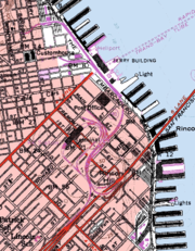
Exit list
Loma Prieta earthquake
The Loma Prieta earthquake, also known as the Quake of '89 and the World Series Earthquake, was a major earthquake that struck the San Francisco Bay Area of California on October 17, 1989, at 5:04 p.m. local time...
and subsequent demolition.
The entire route was in San Francisco.
| Destinations | Notes |
|---|---|
| Southbound exit and northbound entrance | |
| Southbound exit and northbound entrance | |
| Main Street | Northbound exit |
| Beale Street | Southbound entrance |
| Washington Street | Northbound exit |
| Clay Street | Southbound entrance |
| Broadway, Battery Street | Northbound exit |
| Broadway, Sansome Street | Southbound entrance |
| Gap in SR 480 | |
| Marina Blvd | Continuation beyond U.S. 101 |
| Northbound exit and southbound entrance | |
External links
- San Francisco ChronicleSan Francisco Chroniclethumb|right|upright|The Chronicle Building following the [[1906 San Francisco earthquake|1906 earthquake]] and fireThe San Francisco Chronicle is a newspaper serving primarily the San Francisco Bay Area of the U.S. state of California, but distributed throughout Northern and Central California,...
photo of the freeway from 1987 - Congress for the New Urbanism History of Embarcadero
- California Highways (www.cahighways.org) San Francisco-Bay Area Freeway Development (Part 1—The City of San Francisco)
- YouTube - 1984 drive on the San Francisco Embarcadero Freeway (5:29)
- Map of Golden Gate Freeway route alternatives from 1965